
Monroe County is a county in the Commonwealth of Pennsylvania. It is located in Northeastern Pennsylvania. As of the 2020 census, the population was 168,327. Its county seat is Stroudsburg. The county was formed from sections of Northampton and Pike counties on April 1, 1836.

Paradise Township is a township in Monroe County, Pennsylvania in the Pocono Mountains. The population was 2,898 at the 2020 census.

Pennsylvania Route 940 is a 43.2-mile-long (69.5 km) Pennsylvania highway located in the Pocono Mountains. It runs from PA 309 in Hazleton east to PA 191 in Paradise Valley. Large segments of PA 940 are located in densely forested areas. The route heads northeast through Luzerne County from Hazleton, passing through Freeland and coming to an interchange with Interstate 80 (I-80) in White Haven. From here, PA 940 turns east and runs a short distance north of I-80, coming to an interchange with both I-80 and I-476 in northern Carbon County. The route continues through Monroe County and passes through Pocono Pines before it has an interchange with I-380. PA 940 passes through Mount Pocono prior to continuing to its eastern terminus.

Pennsylvania Route 191 is a 111.54 mi (179.51 km)-long state highway in the U.S. state of Pennsylvania. The route, a major non-freeway corridor connecting the Lehigh Valley to the Pocono Mountains in eastern Pennsylvania, is designated from U.S. Route 22 in Brodhead near the city of Bethlehem to the New York state line over the Delaware River at Hancock, New York.

Pennsylvania Route 115 (PA 115) is a 35.7-mile-long (57.5 km) north–south state highway in eastern Pennsylvania. It stretches from U.S. Route 209 (US 209) in Brodheadsville, Monroe County, northwest to Interstate 81 (I-81) and PA 309 near Wilkes-Barre in Luzerne County. PA 115 passes through rural areas along its route, intersecting PA 903 in Tunkhannock Township, I-80 and PA 940 in Tobyhanna Township, and I-476 in Bear Creek Township. The road serves as a connector between the Pocono Mountains and the Wyoming Valley.

Pennsylvania Route 715 (PA 715) is a 17.7-mile-long (28.5 km) north–south state route located entirely in Monroe County, Pennsylvania. Its southern terminus is at U.S. Route 209 (US 209) in the Chestnuthill Township hamlet of Brodheadsville. The northern terminus is at PA 191 in the Paradise Township hamlet of Henryville. PA 715 also intersects Interstate 80 (I-80) in Tannersville at Exit 299. The route is a two-lane undivided road running through forested areas of the Pocono Mountains. The road was paved between 1930 and the 1940s. PA 715 was designated to its present alignment in 1963.
Schrader Creek is a tributary of Towanda Creek in Sullivan County and Bradford County, in Pennsylvania, in the United States. It is approximately 23.4 miles (37.7 km) long and flows through Fox Township in Sullivan County and Leroy Township, Franklin Township, and Monroe Township in Bradford County.
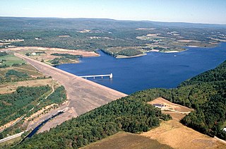
Beltzville State Park is a 2,972.39-acre (1,202.88 ha) Pennsylvania state park in Franklin and Towamensing townships, Carbon County, Pennsylvania in the United States. The park opened in 1972, and was developed around the U.S. Army Corps of Engineers flood control project Beltzville Dam on Pohopoco Creek. The village of Big Creek Valley was vacated in 1966 to make way for Beltzville Lake. Beltzville Lake is a 951.5 acres (385.1 ha) with 19.8 miles (31.9 km) of shoreline. Beltzville State Park is 5 miles (8.0 km) east of Lehighton just off U.S. Route 209. The park is at an elevation of 633 feet (193 m).

Nescopeck State Park is a Pennsylvania state park on 3,550 acres (1,437 ha) in Butler and Dennison Townships, Luzerne County, Pennsylvania. The park is one of the newest state parks in Pennsylvania. In the early 1970s, the state acquired 164 properties which made up the park. The park's Environmental Education Center is one of its newest additions; it opened in April 2005. Nescopeck Creek runs through the valley between Mount Yeager and Nescopeck Mountain. The park is near Interstate 80 just off Pennsylvania Route 309.

Lackawanna State Park is a 1,445-acre (585 ha) Pennsylvania state park in Benton and North Abington Townships, Lackawanna County, Pennsylvania in the United States. Lake Lackawanna, a 198-acre (80 ha) man-made lake, is the central focus of recreation at the park. Lackawanna State Park is located near Dalton on Pennsylvania Route 524 just off exit 199 of Interstate 81.

Pennsylvania Route 196 is a state highway in the Pocono Mountains of Pennsylvania with a length of 25.7 miles (41.4 km). It runs from PA 611 and PA 940 in Mount Pocono in Monroe County north to PA 296 in Varden in Wayne County. The route is a two-lane undivided road that runs through rural areas. PA 196 intersects PA 423 near Tobyhanna State Park before entering Wayne County, where it crosses PA 507 in Angels and passes through Sterling. The route forms a concurrency with PA 191 and has a junction with PA 590 in Hamlin. Upon splitting from PA 191, PA 196 continues north to its end at PA 296.

Pennsylvania Route 314 is an 7.26-mile (11.68 km) state highway located in Monroe County, Pennsylvania. The western terminus is at PA 940 in Pocono Summit. The eastern terminus is at PA 715 in Pocono Township. The route is a two-lane undivided road that passes through forested areas of the Pocono Mountains. In Swiftwater, PA 314 has a short concurrency with PA 611. The road between Pocono Summit and U.S. Route 611 in Swiftwater was designated as PA 15 in 1927 and became PA 115 a year later. PA 940 replaced the PA 115 designation on this stretch in 1935. PA 314 was designated to its current alignment in 1964, replacing this section of PA 940 which was rerouted to the north.

Pennsylvania Route 390 is a 25.3-mile-long (40.7 km) state highway located in Monroe and Pike counties in Pennsylvania. The southern terminus is at PA 940 in Paradise Township. The northern terminus is at PA 507 in Tafton View. The route is a two-lane undivided road that runs through forested areas in the Pocono Mountains. PA 390 begins at PA 940 west of Paradise Valley and heads northeast. The route runs concurrent with PA 191 between Cresco and Mountainhome before it splits and intersects PA 447 in Canadensis. PA 390 passes through Skytop before it crosses the county line and runs through Promised Land State Park. The route has an interchange with Interstate 84 (I-84) before passing through Tafton and ending at PA 507 near Lake Wallenpaupack.

U.S. Route 209 (US 209) is a 211.74-mile (340.76 km) long U.S. Highway in the states of Pennsylvania and New York. Although the route is a spur of US 9, US 209 never intersects US 9, coming within five miles of the route and making the short connection via New York State Route 199 (NY 199). The southern terminus of the route is at Pennsylvania Route 147 (PA 147) in Millersburg, Pennsylvania. The northern terminus is at US 9W north of Kingston in Ulster, New York, where the road continues east as NY 199.

Blakeslee is an unincorporated community in Tobyhanna Township in Monroe County, Pennsylvania, United States. Blakeslee is located at the intersection of Pennsylvania Route 115 and Pennsylvania Route 940.
Snydersville is an unincorporated community in Hamilton Township in Monroe County, Pennsylvania, United States. Snydersville is located at the intersection of U.S. Route 209 Business, Rimrock Road, Pensyl Creek Road, and Middle Easton Belmont Pike.
Sciota is an unincorporated community in Hamilton Township in Monroe County, Pennsylvania, United States. Sciota is located near the interchange between the southern terminus of U.S. Route 209 Business and U.S. Route 209.

Scotrun is an unincorporated community in Pocono Township in Monroe County, Pennsylvania, United States. Scotrun is located in the Pocono Mountains along Pennsylvania Route 611, north of Tannersville and south of Mount Pocono. Popular attractions in Scotrun include the Great Wolf Lodge - Pocono Mountains and the Four Seasons Campground.
Reeders is an unincorporated community in Jackson Township in Monroe County, Pennsylvania, United States. Reeders is located at the intersection of Pennsylvania Route 715 and Reeders Run Road.

Hoffman is an unincorporated community located within Monroe Township in Middlesex County, in the U.S. state of New Jersey. The settlement is located at the site of a former railroad station on the Freehold and Jamesburg Agricultural Railroad. Today, most of the area is made up of homes and housing developments along Hoffman Station Road and Gravel Hill-Spotswood Road. Forestland and the Manalapan Brook valley make up the remainder of the area.


