Pollux Peak

Last updated
Pollux Peak
Pollux and Castor Peaks.jpg
Northwest aspect of Pollux (left) and Castor (right)
Highest point
Elevation 11,063 ft (3,372 m) [1]
Prominence 1,223 ft (373 m) [1]
Parent peak Land Mountain (11,270 ft) [2]
Isolation 4.76 mi (7.66 km) [2]
Coordinates 44°39′58″N109°55′45″W / 44.6662377°N 109.9292862°W / 44.6662377; -109.9292862 [3]
Naming
Etymology Pollux
Geography
USA Wyoming relief location map.svg
Red triangle with thick white border.svg
Pollux Peak
Location in Wyoming
Usa edcp relief location map.png
Red triangle with thick white border.svg
Pollux Peak
Pollux Peak (the United States)
Location Yellowstone National Park
Park County, Wyoming, U.S.
Parent range Absaroka Range
Rocky Mountains
Topo map USGS Pollux Peak
Climbing
Easiest route class 3 scrambling [2]

Pollux Peak is an 11,063-foot-elevation (3,372-meter) mountain summit located in Yellowstone National Park, in Park County, Wyoming, United States. [3]

Contents

Description

The peak is situated in the northeast quadrant of Yellowstone National Park and is the fourth-highest peak within the park. [4] It is part of the Absaroka Range, which is a subset of the Rocky Mountains. Neighbors include Castor Peak 1.4 miles (2.3 km) to the southwest, and Saddle Mountain 4.1 miles (6.6 km) to the northwest on the opposite side of the Lamar River Valley. Topographic relief is significant as the northwest aspect rises over 3,300 feet (1,000 meters) above Lamar River in approximately 1.5 mile. Pollux Peak is named for Pollux, the twin half-brother of Castor according to Greek mythology, and these two gods were considered protectors of travelers, of which there are many in Yellowstone Park. [5] The mountain's name, which was officially adopted in 1930 by the United States Board on Geographic Names, [6] was in use before 1899 when Henry Gannett published it in A Dictionary of Altitudes in the United States. [7]

Climate

According to the Köppen climate classification system, Pollux Peak is located in a subarctic climate zone with long, cold, snowy winters, and cool to warm summers. [8] Winter temperatures can drop below −10 °F with wind chill factors below −30 °F. Precipitation runoff from the mountain drains into tributaries of the Lamar River.

Aerial view of Pollux Peak, south-southwest aspect Pollux looking Northeast August 4, 2019 (crop).jpg
Aerial view of Pollux Peak, south-southwest aspect

See also

Related Research Articles

<span class="mw-page-title-main">Dome Mountain (Wyoming)</span> Mountain in Wyoming, United States

Dome Mountain, elevation 9,903 feet (3,018 m), is a mountain peak in the southern section of the Gallatin Range in Yellowstone National Park, in the U.S. state of Wyoming.

<span class="mw-page-title-main">Three Rivers Peak</span> Mountain in Wyoming, United States

Three Rivers Peak is a 9,958-foot (3,035 m) mountain summit in the southern section of the Gallatin Range in Yellowstone National Park, in the U.S. state of Wyoming.

<span class="mw-page-title-main">Hoyt Peak</span> Summit in Yellowstone National Park, Wyoming

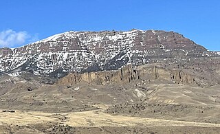
Hoyt Peak is a 10,506 feet (3,202 m) summit located on the shared border of Yellowstone National Park and North Absaroka Wilderness, in Park County, Wyoming.

<span class="mw-page-title-main">Sunshine Mountain</span> Mountain in the state of Colorado

Sunshine Mountain is a 12,930-foot-elevation (3,940-meter) mountain summit located in San Miguel County, in Colorado, United States. It is situated nine miles southwest of the community of Telluride, in the Lizard Head Wilderness, on land managed by Uncompahgre National Forest. It is part of the San Juan Mountains which is a subset of the Rocky Mountains. Sunshine Mountain is situated 24 miles west of the Continental Divide, 2.75 miles east of Wilson Peak, and 1.8 mile northeast of Lizard Head, the nearest higher neighbor. Topographic relief is significant as the west aspect rises 2,700 feet above Bilk Creek in approximately one mile. The mountain is composed of rock of the San Juan Formation overlaying Telluride Conglomerate, in turn overlaying Mancos Shale. The mountain's name, which has been officially adopted by the United States Board on Geographic Names, was in use before 1899 when Henry Gannett published it in A Dictionary of Altitudes in the United States.

<span class="mw-page-title-main">Potosi Peak</span> Mountain in Colorado, United States

Potosi Peak is a 13,786-foot-elevation (4,202-meter) mountain summit located in Ouray County of Colorado, United States. It is situated five miles southwest of the community of Ouray, on land managed by Uncompahgre National Forest. It is part of the Sneffels Range which is a subset of the San Juan Mountains, which in turn is part of the Rocky Mountains. It is situated west of the Continental Divide, 2.2 miles south of Whitehouse Mountain, and 2.5 miles southeast of Mount Sneffels. Potosi ranks as the 113th-highest peak in Colorado, and the fourth-highest in the Sneffels Range. Recreation enthusiasts heading for Yankee Boy Basin traverse below the southern base of the mountain. Topographic relief is significant as the southeast aspect rises 4,000 feet above the Camp Bird Mine in approximately 1.5 mile. The mining activity in the immediate area produced significant amounts of gold and silver. "Potosi" in Quechuan language translates to "great wealth.". The mountain's name, which has been officially adopted by the United States Board on Geographic Names, was in use before 1899 when Henry Gannett published it in A Dictionary of Altitudes in the United States.

<span class="mw-page-title-main">Stony Mountain (Colorado)</span> Mountain in the state of Colorado

Stony Mountain is a 12,698-foot-elevation (3,870-meter) mountain summit located in Ouray County of southwest Colorado, United States. It is situated five miles southwest of the community of Ouray, on land managed by Uncompahgre National Forest. It is part of the Sneffels Range which is a subset of the San Juan Mountains, which in turn is part of the Rocky Mountains. It is situated west of the Continental Divide, 1.3 miles southwest of Potosi Peak, and 1.15 miles northeast of parent Mount Emma. Yankee Boy Basin is surrounded by Stony Mountain, Gilpin Peak, Mount Sneffels, Cirque Mountain, and Teakettle Mountain. Topographic relief is significant as the east aspect rises 2,000 feet above Sneffels Creek in less than one mile. The mountain's name, which has been officially adopted by the United States Board on Geographic Names, was in use before 1899 when Henry Gannett published it in A Dictionary of Altitudes in the United States.

<span class="mw-page-title-main">Wildhorse Peak</span> Mountain in the state of Colorado

Wildhorse Peak is a 13,266-foot-elevation (4,043-meter) mountain summit located in Ouray County, of Colorado, United States. It is situated five miles east of the community of Ouray, in the Uncompahgre Wilderness, on land managed by Uncompahgre National Forest. It is part of the San Juan Mountains which are a subset of the Rocky Mountains, and is situated west of the Continental Divide. Neighbors include Darley Mountain 2.2 miles to the south, and Abrams Mountain five miles to the southwest. This distinctive peak abruptly rises 1,000 feet above the alpine tundra of American Flats, and topographic relief is significant as the northwest aspect rises 1,600 feet above Wildhorse Creek in less than one mile. The peak can be seen from Montrose and Highway 550. The first ascent of the summit was made August 25, 1899, by Eli Stanton, F. H. Stanton, and William Killen. The mountain's name, which has been officially adopted by the United States Board on Geographic Names, was in use in 1906 when Henry Gannett published it in A Gazetteer of Colorado.

<span class="mw-page-title-main">Lookout Peak (Colorado)</span> Mountain in the state of Colorado

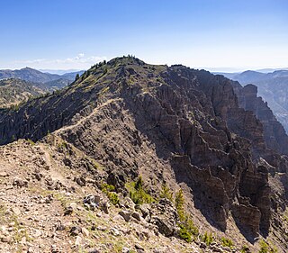
Lookout Peak is a 13,661-foot-elevation (4,164-meter) mountain summit located on the shared boundary of San Juan County with San Miguel County, in southwest Colorado, United States. It is situated three miles east of the community of Ophir, and one mile immediately north of Ophir Pass, on land managed by San Juan National Forest and Uncompahgre National Forest. Lookout Peak is part of the San Juan Mountains which are a subset of the Rocky Mountains, and is west of the Continental Divide. It ranks as the 166th-highest peak in Colorado, and topographic relief is significant as the west aspect rises 3,000 feet in approximately one mile. Neighbors include Silver Mountain three miles to the west-northwest, Wasatch Mountain two miles north-northwest, and Golden Horn five miles south-southwest. The mountain's name, which has been officially adopted by the United States Board on Geographic Names, was in use in 1899 when Henry Gannett published it in A Dictionary of Altitudes in the United States, and in 1906 when he published it in A Gazetteer of Colorado.

<span class="mw-page-title-main">Amphitheater Mountain (Wyoming)</span> Mountain in the state of Wyoming

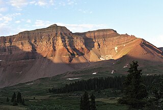
Amphitheater Mountain is a prominent 11,042-foot-elevation (3,366-meter) mountain summit located in Park County, Wyoming, United States.

<span class="mw-page-title-main">Republic Mountain</span> Mountain in the American state of Wyoming

Republic Mountain is a 10,162-foot-elevation (3,097-meter) mountain summit located in Park County, Wyoming, United States.

<span class="mw-page-title-main">Cutoff Mountain</span> Mountain in the American state of Montana

Cutoff Mountain is a 10,695-foot (3,260-metre) mountain summit located in Park County, Montana.

<span class="mw-page-title-main">Saddle Mountain (Wyoming)</span> Mountain in the state of Wyoming

Saddle Mountain is a 10,670-foot-elevation (3,250-meter) mountain summit located in Yellowstone National Park, in Park County, Wyoming, United States.

<span class="mw-page-title-main">Top Notch Peak</span>

Top Notch Peak is a 10,245-foot-elevation (3,123 meter) mountain summit located in Yellowstone National Park, in Park County, Wyoming, United States.

<span class="mw-page-title-main">Silvertip Peak (Wyoming)</span> Mountain in the American state of Wyoming

Silvertip Peak is a 10,645-foot-elevation (3,245-meter) mountain summit located in Park County, Wyoming, United States.

<span class="mw-page-title-main">Hoodoo Peak (Wyoming)</span> Mountain in the American state of Wyoming

Hoodoo Peak is a 10,571-foot-elevation (3,222-meter) mountain summit located in Park County, Wyoming, United States.

<span class="mw-page-title-main">Heavenly Twins (Montana)</span> Double summit mountain in the state of Montana

Heavenly Twins is a 9,282-foot elevation (2,829 m) double summit mountain located in Ravalli County, Montana.

<span class="mw-page-title-main">Babcock Peak</span> Mountain in the American state of Colorado

Babcock Peak is a 13,161-foot-elevation (4,011-meter) mountain summit in La Plata County, Colorado.

<span class="mw-page-title-main">Grizzly Peak (Dolores/San Juan Counties, Colorado)</span> Mountain in the state of Colorado

Grizzly Peak is a 13,738-foot-elevation (4,187-meter) mountain summit on the boundary shared by Dolores County and San Juan County, in Colorado, United States.

<span class="mw-page-title-main">Henrys Fork Peak</span>

Henrys Fork Peak is a 13,260-foot elevation (4,042 m) mountain summit located on the common border that Duchesne County shares with Summit County in the U.S. state of Utah.

<span class="mw-page-title-main">Jim Mountain</span>

Jim Mountain is a 10,430-foot-elevation (3,179-meter) summit in Park County, Wyoming, United States.

References

  1. 1 2 "Pollux Peak, Wyoming". Peakbagger.com. Retrieved 2021-11-12.
  2. 1 2 3 "Pollux Peak - 11,063' WY". listsofjohn.com. Retrieved 2021-11-12.
  3. 1 2 "Pollux Peak". Geographic Names Information System . United States Geological Survey, United States Department of the Interior . Retrieved 2021-11-12.
  4. Pollux Peak, Peakvisor.com
  5. By Paul Rubinstein, Lee H. Whittlesey, Mike Stevens, 2000, The Guide to Yellowstone Waterfalls and Their Discovery, Westcliffe Publishers, ISBN   9781565793514, page 242.
  6. Decisions of the United States Geographic Board, Place Names, Yellowstone National Park, Wyo. May 7, 1930. page 19.
  7. Henry Gannett, A Dictionary of Altitudes in the United States, 1899, US Government Printing Office, page 773.
  8. Peel, M. C.; Finlayson, B. L.; McMahon, T. A. (2007). "Updated world map of the Köppen−Geiger climate classification". Hydrol. Earth Syst. Sci. 11 (5): 1633. Bibcode:2007HESS...11.1633P. doi: 10.5194/hess-11-1633-2007 . ISSN   1027-5606. S2CID   9654551.