New Haven is a city in New Haven County, Connecticut, United States. It is located on New Haven Harbor on the northern shore of Long Island Sound and is part of the New York City metropolitan area. With a population of 135,081 as determined by the 2020 U.S. census, New Haven is the third largest city in Connecticut after Bridgeport and Stamford, the largest city in the South Central Connecticut Planning Region, and the principal municipality of Greater New Haven, which had a total population of 864,835 in 2020. Prior to 1960, it was the county seat of New Haven County until the county governments were abolished that year.
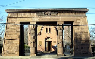
Grove Street Cemetery or Grove Street Burial Ground is a cemetery in New Haven, Connecticut, that is surrounded by the Yale University campus. It was organized in 1796 as the New Haven Burying Ground and incorporated in October 1797 to replace the crowded burial ground on the New Haven Green. The first private, nonprofit cemetery in the world, it was one of the earliest burial grounds to have a planned layout, with plots permanently owned by individual families, a structured arrangement of ornamental plantings, and paved and named streets and avenues. By introducing ideas like permanent memorials and the sanctity of the deceased body, the cemetery became "a real turning point... a whole redefinition of how people viewed death and dying", according to historian Peter Dobkin Hall. Many notable Yale and New Haven luminaries are buried in the Grove Street Cemetery, including 14 Yale presidents; nevertheless, it was not restricted to members of the upper class, and was open to all.

The New Haven Green is a 16-acre (65,000 m2) privately owned park and recreation area located in the downtown district of the city of New Haven, Connecticut, United States. It comprises the central square of the nine-square settlement plan of the original Puritan colonists in New Haven, and was designed and surveyed by colonist John Brockett. Today the Green is bordered by the modern paved roads of College, Chapel, Church, and Elm streets. Temple Street bisects the Green into upper (northwest) and lower (southeast) halves.

Downtown New Haven is the neighborhood located in the heart of the city of New Haven, Connecticut. It is made up of the original nine squares laid out in 1638 to form New Haven, including the New Haven Green, and the immediate surrounding central business district, as well as a significant portion of the Yale University campus. The area includes many restaurants, cafes, theaters and stores. Downtown is bordered by Wooster Square to the east, Long Wharf to the southeast, the Hill neighborhood to the south, the Dwight neighborhood to the west, the Dixwell neighborhood to the northwest, the Prospect Hill area to the north, and East Rock to the northeast.

Westville is a neighborhood of the city of New Haven, Connecticut. The area is positively reviewed for its walkability, diverse population, and livability. It is more expensive than the average American city, has lower crime rates, and graduates children from high school at rates above the national average.
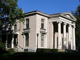
Hillhouse Avenue is a street in New Haven, Connecticut, famous for its many nineteenth century mansions, including the president's house at Yale University. Both Charles Dickens and Mark Twain have described it as "the most beautiful street in America." Much of the avenue is included in the Hillhouse Avenue Historic District, which extends to include houses on adjacent streets.

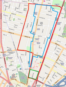
Edgewood Historic District is a historic district located in the west-central portion of New Haven, Connecticut. It was listed on the National Register of Historic Places in 1986. A predominantly residential area roughly bisected by Edgewood Avenue, a broad boulevard which features a large central esplanade and forms the principal east-west artery through the heart of the district. The area includes 232 contributing buildings, 4 other contributing structures, and 1 contributing object. Most of these were built between about 1888 and 1900, and represent the city's first neighborhood planned under the tenets of the City Beautiful movement. They are generally either Queen Anne or Colonial Revival in style, and are set on larger lots.

Whitneyville is a neighborhood in the southeastern portion of the town of Hamden, Connecticut. It started in the early nineteenth century as a factory town for workers in Eli Whitney's gun factory. Around the turn of the twentieth century, it evolved into a trolley suburb of New Haven. Today it is primarily residential, with a mixture of single-family homes and small apartment and condominium buildings. There is some commercial development centered around the intersection of Whitney and Putnam avenues.

The Howard Avenue Historic District is a 32-acre (13 ha) historic district in The Hill neighborhood of the city of New Haven, Connecticut. Extending along Howard Avenue between Minor Street and Interstate 95, it contains an unusually high concentration of well-preserved late 19th-century middle class vernacular architecture, reflecting the area's growth at that time. It was listed on the National Register of Historic Places in 1985.
The Prospect Hill Historic District is an irregularly-shaped 185-acre (75 ha) historic district in New Haven, Connecticut. The district encompasses most of the residential portion of the Prospect Hill neighborhood.

The Whitney Avenue Historic District is a historic district in the East Rock neighborhood of New Haven, Connecticut. It is a 203-acre (82 ha) district which included 1,084 contributing buildings when it was listed on the National Register of Historic Places in 1989.

The Winchester Repeating Arms Company Historic District is a historic district in New Haven, Connecticut that was listed on the National Register of Historic Places in 1988. It includes 867 properties, which "include 858 major structures and 131 notable outbuildings." Of these structures, 876 are buildings deemed to contribute to the historical and/or architectural significance of the area, and most of these are residential. However the center of the district is "dominated" by the 75-acre (30 ha) tract of the former Winchester Repeating Arms Company, which contains industrial buildings.

This is a list of National Register of Historic Places listings in New Haven, Connecticut.
Beaver Hills is a neighborhood in the city of New Haven, Connecticut. The older, east central portion of the neighborhood is listed on the National Register of Historic Places as the Beaver Hills Historic District. The southwest portion is a state historic district called the Fairlawn-Nettleton Historic District.

The Beaver Hills Historic District is a 97-acre (39 ha) historic district in the Beaver Hills neighborhood of New Haven, Connecticut. It was listed on the National Register of Historic Places in 1986. In 1986, it included 235 contributing buildings.

Newington Junction is a section of the town of Newington, Connecticut. It is centered at the intersection of Willard Avenue and West Hill Road in the northwestern part of the town, in the area generally just south of the Hartford city line. The name of the area refers to the railroad junction where the railroad line from New Haven meets with the railroad line from Bristol and Waterbury. The development of Newington Junction as a result of the railroad was instrumental in the separation of the town of Newington from its mother town of Wethersfield.
The city of New Haven, Connecticut has many distinct neighborhoods. In addition to Downtown, centered on the central business district and the Green, are the following neighborhoods: the west central neighborhoods of Dixwell and Dwight; the southern neighborhoods of The Hill, historic water-front City Point, and the harborside district of Long Wharf; the western neighborhoods of Edgewood, West River, Westville, Amity, and West Rock; East Rock, Cedar Hill, Prospect Hill, and Newhallville in the northern side of town; the east central neighborhoods of Mill River and Wooster Square, an Italian-American neighborhood; Fair Haven, an immigrant community located between the Mill and Quinnipiac rivers; Quinnipiac Meadows and Fair Haven Heights across the Quinnipiac River; and facing the eastern side of the harbor, The Annex and East Shore.
Whitney Avenue is a principal arterial connecting Downtown New Haven with the town center of Hamden in the U.S. state of Connecticut. Most of the road within the city of New Haven is included in the Whitney Avenue Historic District, which is listed on the National Register of Historic Places. The designation begins at Grove Street in the northern part of Downtown New Haven and extends through the town of Hamden up to the Cheshire town line. North of Dixwell Avenue in Hamden Center, the road is a state highway and designated as part of Route 10. From the New Haven town line to Dixwell Avenue, the road is state-maintained with an unsigned designation of State Road 707. Within New Haven, Whitney Avenue is a town road. The J route of Connecticut Transit New Haven, which connects New Haven to Waterbury, runs along Whitney Avenue.
J. Frederick Kelly (1888–1947) was an American architect who has designed significant houses. Kelly was regarded as the leading architectural historian in Connecticut.

Science Hill is an area of the Yale University campus primarily devoted to physical and biological sciences. It is located in the Prospect Hill neighborhood of New Haven, Connecticut.