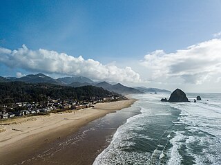
Cannon Beach is a city in Clatsop County, Oregon, United States. The population was 1,690 at the 2010 census. Cannon Beach is a popular coastal tourist destination in Oregon, famous for Haystack Rock, a 235 ft (72 m) sea stack that juts out along the Pacific Coast. In 2013, National Geographic listed Cannon Beach as "one of the world’s 100 most beautiful places."

Lincoln City is a city in Lincoln County on the Oregon Coast between Tillamook and Newport. It is named after the county, which was named in honor of former U.S. President Abraham Lincoln. The population was 7,930 at the 2010 Census. During the solar eclipse of August 21, 2017, this city was the first in the path of totality to view a total solar eclipse.

Yachats is a small coastal city in Lincoln County, Oregon, United States. According to Oregon Geographic Names, the name comes from the Siletz language and means "dark water at the foot of the mountain". There is a range of differing etymologies, however. William Bright says the name comes from the Alsea placename yáx̣ayky. At the 2010 census, the city's population was 690. In 2007, Budget Travel magazine named Yachats one of the "Ten Coolest Small Towns of the U.S.A.", and Yachats was chosen among the top 10 U.S. up-and-coming vacation destinations by Virtualtourist. In 2011, Arthur Frommer, founder of Frommer's Travel Guides, listed Yachats number seven among his ten favorite vacation destinations in the world.

Multnomah Falls is a waterfall located on Multnomah Creek in the Columbia River Gorge, east of Troutdale, between Corbett and Dodson, Oregon, United States. The waterfall is accessible from the Historic Columbia River Highway and Interstate 84. Spanning two tiers on basalt cliffs, it is the tallest waterfall in the state of Oregon at 620 ft (189 m) in height.

The Oregon Coast is a coastal region of the U.S. state of Oregon. It is bordered by the Pacific Ocean to its west and the Oregon Coast Range to the east, and stretches approximately 362 miles (583 km) from the California state border in the south to the Columbia River in the north. The region is not a specific geological, environmental, or political entity, and includes the Columbia River Estuary.

Cape Blanco is a prominent headland on the Pacific Ocean coast of southwestern Oregon in the United States, forming the westernmost point in the state. Cape Blanco extends further west than any point of land in the contiguous United States except portions of the Olympic Peninsula in Washington, including Cape Alava, the true westernmost point. The cape is part of Cape Blanco State Park and is the location of the Cape Blanco Light, first lit in 1870.

U.S. Route 101 (US 101), is a major north–south U.S. Highway in Oregon that runs through the state along the coastline near the Pacific Ocean. It runs from the California border, south of Brookings, to the Washington state line on the Columbia River, between Astoria, Oregon, and Megler, Washington.
Agness is an unincorporated community in Curry County, Oregon, United States. It is near the confluence of two Wild and Scenic rivers—the Lower Rogue and the Illinois. Agness post office was established October 16, 1897. It was named after Agnes, the daughter of the first postmaster, and subsequently misspelled. The Agness area is popular for fishing and hiking. Agness is in the Rogue River–Siskiyou National Forest and was threatened by the Biscuit Fire in 2002.

Agate Beach is an unincorporated community in Lincoln County, Oregon, United States. Agate Beach is named for the agates that are found on the beaches of the Pacific Ocean between Newport and Yaquina Head. Agate Beach post office was established in 1912 and closed in 1971.

Kernville is an unincorporated community in Lincoln County, Oregon, United States. It is located near the intersection of U.S. Route 101 and Oregon Route 229, where the Siletz River enters Siletz Bay. There are two communities, known as "old" and "new" Kernville, in close proximity. Old Kernville is considered a ghost town.

Otter Rock is an unincorporated community in Lincoln County, Oregon, United States. It is located on U.S. Route 101 along the Oregon Coast. Otter Rock is 5.4 miles south of Depoe Bay and 8 miles north of Newport, Oregon. Otter Rock takes its name from a rock located about 1⁄2 mile (0.8 km) offshore and 3.25 miles (5.23 km) north of Yaquina Head where sea otters formerly lived.

The Cummins Creek Wilderness is a 9,300-acre (3,800 ha) wilderness area in the Siuslaw National Forest within the Oregon Coast. It is one of three wilderness areas created in the Siuslaw in 1984, along with Drift Creek and Rock Creek. It is "dedicated to preserve in a wilderness state, the last remaining virgin stands of Sitka spruce, western hemlock and Douglas-fir, in Oregon's coast lands." Cummins Creek and nearby Cummins Ridge are named for F.L. Cummins, an early homesteader.

Gardiner is an unincorporated community and census-designated place in Douglas County, Oregon, United States, across the Umpqua River from Reedsport. It is located on U.S. Route 101. As of the 2010 census, it had a population of 248.

Oregon Islands National Wildlife Refuge is a U.S. National Wildlife Refuge off the southwestern Oregon Coast. It is one of six National Wildlife Refuges comprising the Oregon Coast National Wildlife Refuge Complex. The Oregon Islands provides wilderness protection to 1,853 small islands, rocks, and reefs plus two headlands, totaling 371 acres (150 ha) spanning 1,083 acres (438 ha) of Oregon's coastline from the Oregon–California border to Tillamook Head. There are sites in six of the seven coastal counties of Oregon. From north to south they are Clatsop, Tillamook, Lincoln, Lane, Coos, and Curry counties.

Cape Perpetua is a large forested headland projecting into the Pacific Ocean on the central Oregon Coast in Lincoln County, Oregon. The land is managed by the United States Forest Service as part of the Siuslaw National Forest.

Manhattan Beach State Recreation Site is a state park in the U.S. state of Oregon. Administered by the Oregon Parks and Recreation Department, the park is open to the public and is fee-free. Amenities at the park, which is 2 miles (3 km) north of Rockaway Beach along U.S. Route 101, include picnicking, fishing, and a Pacific Ocean beach.

Arizona Beach State Recreation Site is a 68-acre (28 ha) Oregon state park in Curry County, Oregon, in the United States. The beach is at an average elevation of 7 feet (2 m). Public recreational facilities at Arizona Beach State Recreation Site include a parking lot for beach access, observation areas for viewing marine mammals and birds and tables for picnicking. The park is open year-round.
Siltcoos is an unincorporated community in Lane County, Oregon, United States. It is about 13 miles (21 km) south of Florence on the east shore of Siltcoos Lake.
Oretown is an unincorporated community in Tillamook County, Oregon, United States. It is along U.S. Route 101 about 4 miles (6 km) north of Neskowin and south of Nestucca Bay.
Brian Booth State Park is a coastal recreational area located near Seal Rock, Oregon. It consists of two major portions: Ona Beach State Park and Beaver Creek State Natural Area. The park has beach access, kayaking, and hiking trails. The park is 886.32 acres and has an annual attendance of 247,772 people. Ona is known as a Chinook Jargon word for razor clam.


