Newport, Oregon

Last updated

Newport, Oregon
City of Newport
Newport.jpg
Port of Newport and Yaquina Bay Bridge (U.S. Route 101)
Motto: 
"The Friendliest"
Lincoln County Oregon Incorporated and Unincorporated areas Newport Highlighted.svg
Location of Newport in Lincoln County, Oregon (left) and in Oregon (right)
Coordinates: 44°36′N124°3′W / 44.600°N 124.050°W / 44.600; -124.050
Country United States
State Oregon
County Lincoln
Incorporated 1882
Government
   Mayor Jan Kaplan [1]
Area
[2]
  Total11.72 sq mi (30.35 km2)
  Land9.98 sq mi (25.84 km2)
  Water1.74 sq mi (4.52 km2)
Elevation
134 ft (40.8 m)
Population
 (2020) [3]
  Total10,256
  Density1,028.07/sq mi (396.96/km2)
Time zone UTC-8 (PST)
  Summer (DST) UTC-7 (PDT)
ZIP Codes
97365-97366
Area code 541
FIPS code 41-52450
GNIS feature ID1124669 [4]
Website City of Newport

Newport is a city in Lincoln County, Oregon, United States. It was incorporated in 1882, though the name dates back to the establishment of a post office in 1868. Newport was named for Newport, Rhode Island. [5] As of the 2010 census, the city had a total population of 9,989, an increase of nearly 5% over its 2000 population; as of 2019, it had an estimated population of 10,853. [6]

Contents

The area was originally home to the Yacona tribe, whose history can be traced back at least 3000 years. White settlers began homesteading the area in 1864. The town was named by Sam Case, who also became the first postmaster. [7]

Newport has been the county seat of Lincoln County since 1952, when voters approved a measure to move the center of government from nearby Toledo to Newport. [8] It is also home of the Oregon Coast Aquarium, Hatfield Marine Science Center, Nye Beach, Yaquina Head Light, Yaquina Bay Light, Newport Sea Lion Docks, Pacific Maritime Heritage Center, and Rogue Ales. The city is the western terminus of U.S. Route 20, a cross-country highway that originates in Boston and is the longest road in the United States.

Geography

According to the U.S. Census Bureau, the city has a total area of 10.59 square miles (27.43 km2), of which 9.05 square miles (23.44 km2) is land [6] and 1.54 square miles (3.99 km2) is water. [9] It is located 3,365 miles (5,415.44 km²) west of Boston, Massachusetts on road signs for US-20.

Climate

Newport has mild, wet weather throughout the year with the heaviest precipitation falling during the winter months. The city averages 0.4 afternoons annually with maximum temperatures equalling or exceeding 90 °F or 32.2 °C and 29 mornings with minimum temperatures of 32 °F or 0 °C or lower. [10] Historic extreme temperatures have varied between 1 °F (−17.2 °C) in winter and 100 °F (37.8 °C) in summer. [10]

The average annual precipitation between 1961 and 1990 was 70.99 inches (1,803 mm), [10] with the wettest period being from July 1968 to June 1969 with 102.15 inches (2,594.6 mm) and the driest, like most of Oregon, from July 1976 to June 1977 with 38.94 inches (989.1 mm). There are an average of 187 days a year with precipitation equalling or exceeding 0.01 inches or 0.3 millimetres. [10] Average annual snowfall is only 1.57 in (4.0 cm). [10]

In October 1962, wind gusts at Newport reached 138 miles per hour (222 km/h) before the wind gauge stopped working. This occurred during the Columbus Day Windstorm, which the National Weather Service has named one of Oregon's top 10 weather events of the 20th century. [11]

Another top-10 event affecting Newport occurred in December 1964, when a rainstorm caused severe flooding in many parts of the state. The Weather Service rated the storm among the most severe in western Oregon since the 1870s. About 21 inches (530 mm) of rain fell on Newport. This was almost twice the normal amount expected in December and set a new record for the city. [11]

Also in the Weather Bureau's top-10 list for Oregon are the snowstorms of January 1950. Newport saw a total of about 6 in (15 cm) fall during the month, four times its normal annual snowfall. [11]

Climate data for Newport, Oregon (1991–2020 normals, extremes 1893–2012)
MonthJanFebMarAprMayJunJulAugSepOctNovDecYear
Record high °F (°C)77
(25)
77
(25)
80
(27)
81
(27)
82
(28)
90
(32)
84
(29)
88
(31)
91
(33)
94
(34)
85
(29)
73
(23)
94
(34)
Mean maximum °F (°C)60.7
(15.9)
64.6
(18.1)
65.2
(18.4)
65.8
(18.8)
69.7
(20.9)
68.7
(20.4)
70.0
(21.1)
71.8
(22.1)
76.8
(24.9)
74.9
(23.8)
64.5
(18.1)
59.8
(15.4)
80.5
(26.9)
Mean daily maximum °F (°C)50.3
(10.2)
51.6
(10.9)
52.8
(11.6)
54.3
(12.4)
58.1
(14.5)
61.2
(16.2)
63.5
(17.5)
64.1
(17.8)
63.6
(17.6)
59.6
(15.3)
53.7
(12.1)
50.3
(10.2)
56.9
(13.9)
Mean daily minimum °F (°C)39.3
(4.1)
39.2
(4.0)
39.2
(4.0)
41.2
(5.1)
45.9
(7.7)
48.8
(9.3)
51.2
(10.7)
52.2
(11.2)
48.9
(9.4)
45.1
(7.3)
41.7
(5.4)
39.2
(4.0)
44.3
(6.9)
Mean minimum °F (°C)29.6
(−1.3)
29.5
(−1.4)
31.9
(−0.1)
34.3
(1.3)
38.6
(3.7)
43.9
(6.6)
46.0
(7.8)
46.7
(8.2)
43.0
(6.1)
37.4
(3.0)
32.6
(0.3)
29.6
(−1.3)
25.1
(−3.8)
Record low °F (°C)10
(−12)
12
(−11)
21
(−6)
20
(−7)
28
(−2)
25
(−4)
33
(1)
32
(0)
31
(−1)
25
(−4)
18
(−8)
6
(−14)
6
(−14)
Average precipitation inches (mm)10.33
(262)
8.38
(213)
6.82
(173)
5.53
(140)
2.96
(75)
2.16
(55)
0.59
(15)
0.74
(19)
2.33
(59)
5.56
(141)
10.24
(260)
11.63
(295)
67.27
(1,707)
Average snowfall inches (cm)0.0
(0.0)
0.0
(0.0)
0.0
(0.0)
0.0
(0.0)
0.0
(0.0)
0.0
(0.0)
0.0
(0.0)
0.0
(0.0)
0.0
(0.0)
0.0
(0.0)
0.0
(0.0)
0.1
(0.25)
0.1
(0.25)
Average precipitation days (≥ 0.01 in)20.416.620.916.613.310.85.15.57.315.219.520.0171.2
Average snowy days (≥ 0.1 in)0.00.10.00.00.00.00.00.00.00.00.00.10.2
Average relative humidity (%)82838381818281828181838382
Mean daily sunshine hours 4.04.05.57.48.49.410.710.49.05.34.44.26.9
Mean daily daylight hours 9.310.512.013.514.815.515.214.012.510.99.68.912.2
Average ultraviolet index 3233445443223
Source 1: NOAA [12] [13]
Source 2: Weather Atlas (UV and humidity) [14]

Demographics

Historical population
CensusPop.Note
1880 52
1890 121132.7%
1900 256111.6%
1910 721181.6%
1920 98035.9%
1930 1,53056.1%
1940 2,01932.0%
1950 3,24160.5%
1960 5,34464.9%
1970 5,188−2.9%
1980 7,51944.9%
1990 8,43712.2%
2000 9,53213.0%
2010 9,9894.8%
2020 10,2562.7%
Sources: [15] [16] [17] [18] [19] [3]

2020 census

As of the 2020 census, there were 10,256 people, and 4,559 households in the city. [20] The population density was about 1,028 people per square mile. The racial makeup of the city was 80.9% White, 1.0% African American, 1.8% Native American, 1.7% Asian, 0.0% Pacific Islander, and 5.8% two or more races. Hispanic or Latino of any race were 15.8% of the population. [20]

There were 4,559 households, and the average household size was 2.2 persons. [20]

Around 16.6% of people living in Newport were under 18, with a further 4.1% of people under 5. 27.6% of the population were older than 65. The gender makeup for Newport was 51.9% female and 48.9% male. [20]

The median household income was $52,897, and the per capita income was $30,060. 14.1% of the population were in poverty. [20]

2010 census

As of the census [21] of 2010, there were 9,989 people, 4,354 households, and 2,479 families living in the city. The population density was about 1,104 inhabitants per square mile (426.3/km2). There were 5,540 housing units at an average density of about 612 per square mile (236.3/km2). The racial makeup of the city was 84.1% White, 0.6% African American, 2.1% Native American, 1.6% Asian, 0.2% Pacific Islander, 7.5% from other races, and 3.9% from two or more races. Hispanic or Latino of any race were 15.3% of the population.

There were 4,354 households, of which about 25% had children under the age of 18 living with them, 41% were married couples living together, 11% had a female householder with no husband present, 5% had a male householder with no wife present, and 43% were non-families. About 35% of all households were made up of individuals, and about 15% had someone living alone who was 65 years of age or older. The average household size was about 2.2 and the average family size was about 2.8.

The median age in the city was about 43 years. About 20% of residents were under the age of 18, 8% were between the ages of 18 and 24, 24% were from 25 to 44, 29% were from 45 to 64, and 19% were 65 years of age or older. The gender makeup of the city was 49.1% male and 50.9% female.

Economy

Harbor in Yaquina Bay, Newport Newport harbor (OR).jpg
Harbor in Yaquina Bay, Newport

In August 2011, the National Oceanic and Atmospheric Administration moved its base for research ships from Seattle to Newport. The base boasts about 110 marine officers and a total of 175 employees. It bases four ships, including the NOAAS Bell M. Shimada and the NOAAS Rainier, and it provides support for up to two itinerant vessels. [22] NOAA has personnel at the Hatfield Marine Science Center which support the fisheries science centers for Alaska and the Northwest. The ships join the R/V Oceanus and R/V Elakha research vessels based at the center.

Newport is home to the largest fishing fleet on the Oregon Coast.

Education

Lincoln County voters established Oregon Coast Community College in 1987, in which year the college held its first classes. [23] The public schools in Newport are part of the Lincoln County School District, and include Newport High School, Newport Preparatory Academy, Newport Intermediate School, and Sam Case Primary School.

Newport is also home to the Hatfield Marine Science Center, operated by Oregon State University in collaboration with state and federal agencies. The center conducts research and educational programs associated with the marine environment and serves as a primary field station for the university's College of Oceanic and Atmospheric Sciences. [24]

Government

Newport is a charter city (also called a home rule city) and has a council-manager form of government. The city council consists of a Mayor who chairs the meetings, and 6 councilors. The mayor and city council served staggered terms, between two and four years. Live and archived video of city council and committee meetings is available anytime on at https://newportoregon.gov/citygov/comm/cc.asp

Media

Radio stations

Newport has several locally based stations:

Newspaper

The Lincoln County Leader is published once a week

Sister city

Newport has one sister city: [25]

Notable people

Newport bayfront as seen in the mid-1910s Cc-newport-bayfront-c1915.jpg
Newport bayfront as seen in the mid-1910s

See also

Yaquina Bay Light Yaquina Bay Lighthouse, 2022.jpg
Yaquina Bay Light

Related Research Articles

<span class="mw-page-title-main">Lincoln County, Oregon</span> County in Oregon, United States

Lincoln County is one of the 36 counties in the U.S. state of Oregon. As of the 2020 census, its population was 50,395. The county seat is Newport. The county is named for Abraham Lincoln, 16th president of the United States.

<span class="mw-page-title-main">Logan County, Illinois</span> County in Illinois, United States

Logan County is a county located in the U.S. state of Illinois. According to the 2020 census, it had a population of 27,987. Its county seat is Lincoln.

<span class="mw-page-title-main">Coquille, Oregon</span> City in Oregon, United States

Coquille is a city in, and the county seat of, Coos County, Oregon, United States. The population was 4,015 at the 2020 census. The primary economic base is the timber industry. The city derives its name from the Coquille Native American tribe.

<span class="mw-page-title-main">North Bend, Oregon</span> City in Oregon, United States

North Bend is a city in Coos County, Oregon, United States with a population of 9,695 as of the 2010 census. North Bend is surrounded on three sides by Coos Bay, an S-shaped water inlet and estuary where the Coos River enters Coos Bay and borders the city of Coos Bay to the south. North Bend became an incorporated city in 1903.

<span class="mw-page-title-main">Gold Beach, Oregon</span> City in Oregon, United States

Gold Beach is a city in and the county seat of Curry County, Oregon, United States, on the Oregon Coast. The population was 2,241 at the 2020 census.

<span class="mw-page-title-main">Harbor, Oregon</span> Unincorporated community in the state of Oregon, United States

Harbor is an unincorporated community in Curry County, Oregon, United States. It is located across the Chetco River from the city of Brookings. For statistical purposes, the United States Census Bureau has defined Harbor as a census-designated place (CDP). The census definition of the area may not precisely correspond to local understanding of the area with the same name. The population of the CDP was 2,391 at the 2010 census.

<span class="mw-page-title-main">Drain, Oregon</span> City in Oregon, United States

Drain is a city in Douglas County, Oregon, United States. The population was 1,151 at the 2010 census. Drain is named after town founder and politician Charles J. Drain, who donated 60 acres (24 ha) of nearby land to the Oregon and California Railroad in 1871.

<span class="mw-page-title-main">Monument, Oregon</span> City in Oregon, United States

Monument is a city in Grant County, Oregon, United States. The population was 128 at the 2010 census. It is located near the confluence of the North and Middle Forks of the John Day River. Its post office was established in 1874 and named for a nearby mountain or rock formation.

<span class="mw-page-title-main">Lowell, Oregon</span> City in Oregon, United States

Lowell is a city in Lane County, in the U.S. state of Oregon. As of the 2010 census, the city population was 1,045. The city is on the north shore of Dexter Reservoir on the Middle Fork Willamette River. The most used route to Lowell is along Lowell Bridge, a covered bridge that crosses the reservoir from Oregon Route 58.

<span class="mw-page-title-main">Lincoln Beach, Oregon</span> Unincorporated community in the state of Oregon, United States

Lincoln Beach is a census-designated place (CDP) in Lincoln County, Oregon, United States. It includes the unincorporated communities of Lincoln Beach and Gleneden Beach. The total population was 2,045 at the 2010 census.

<span class="mw-page-title-main">Lincoln City, Oregon</span> City in Oregon, United States

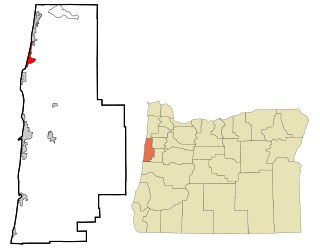
Lincoln City is a city in Lincoln County on the Oregon Coast of the United States, between Tillamook to the north and Newport to the south. It is named after the county, which was named in honor of former U.S. President Abraham Lincoln. The population was 9,815 at the 2020 Census.

<span class="mw-page-title-main">Toledo, Oregon</span> City in Oregon, United States

Toledo is a city located on the Yaquina River and along U.S. Route 20 in Lincoln County, in the U.S. state of Oregon. The population was 3,465 at the 2010 census. The city was a 2009 All-America City Award finalist.

<span class="mw-page-title-main">Waldport, Oregon</span> City in Oregon, United States

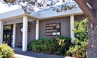
Waldport is a city in Lincoln County, Oregon, United States. The population was 2,033 at the 2010 census. The city is located on the Alsea River and Alsea Bay, 15 miles (24 km) south of Newport and 8 miles (13 km) north of Yachats.

<span class="mw-page-title-main">Yachats, Oregon</span> City in Oregon, United States

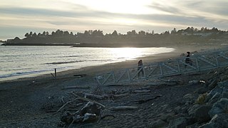
Yachats is a small coastal city in the southernmost area of Lincoln County, Oregon, United States. According to Oregon Geographic Names, the name comes from the Siletz language and means "dark water at the foot of the mountain". There is a range of differing etymologies. William Bright says the name comes from the Alsea placename yáx̣ayky. At the 2020 census, the city's population was 994.

<span class="mw-page-title-main">Tillamook, Oregon</span> City in Oregon, United States

The city of Tillamook is the county seat of Tillamook County, Oregon, United States. The city is located on the southeast end of Tillamook Bay on the Pacific Ocean. The population was 5,231 at the 2020 census.

<span class="mw-page-title-main">Fayetteville, Tennessee</span> City in Tennessee, United States

Fayetteville is a city and the county seat of Lincoln County, Tennessee, United States. The population was 6,994 at the 2000 census, and 6,827 at the 2010 census. A census estimate from 2018 showed 7,017.

<span class="mw-page-title-main">Kemmerer, Wyoming</span> City in Wyoming, United States

Kemmerer is the largest city in and the county seat of Lincoln County, Wyoming, United States. Its population was 2,415 at the 2020 census.

<span class="mw-page-title-main">Yaquina River</span> River in Oregon, United States

The Yaquina River is a stream, 59 miles (95 km) long, on the Pacific coast of the U.S. state of Oregon. It drains an area of the Central Oregon Coast Range west of the Willamette Valley near Newport.

<span class="mw-page-title-main">Yaquina Bay</span> Small bay partially within Newport, Oregon, United States

Yaquina Bay is a coastal estuarine community found in Newport, Oregon. Yaquina Bay is a semi-enclosed body of water, approximately 8 km2 (3.2 mi2) in area, with free connection to the Pacific Ocean, but also diluted with freshwater from the Yaquina River land drainage. The Bay is traversed by the Yaquina Bay Bridge.

<i>T.M. Richardson</i>

T.M. Richardson was a steamboat built in 1888 at Oneatta, Oregon, which served on Yaquina Bay and on the Yaquina River from 1888 to 1908. This vessel was commonly known as the Richardson or the T.M.

References

  1. "City Government" . Retrieved November 21, 2023.
  2. "ArcGIS REST Services Directory". United States Census Bureau. Retrieved October 12, 2022.
  3. 1 2 "Census Population API". United States Census Bureau. Retrieved October 12, 2022.
  4. "US Board on Geographic Names". United States Geological Survey. October 25, 2007. Retrieved January 31, 2008.
  5. Gilden, Jennifer (1999). "Oregon's changing coastal fishing communities".
  6. 1 2 "Newport (city), Oregon". State & County QuickFacts. U.S. Census Bureau. Archived from the original on August 9, 2014. Retrieved June 27, 2014.
  7. "Newport".
  8. "Find a County". National Association of Counties. Retrieved June 7, 2011.
  9. "US Gazetteer files 2010". United States Census Bureau. Archived from the original on January 25, 2012. Retrieved December 21, 2012.
  10. 1 2 3 4 5 Taylor, George H.; Hannan, Chris (1999). The Climate of Oregon: From Rain Forest to Desert. Corvallis: Oregon State University Press. p. 131. ISBN   0-87071-468-6.
  11. 1 2 3 "Oregon's Top 10 Weather Events of 1900s". National Weather Service. Retrieved March 3, 2015.
  12. "NOAA NCEI U.S. Climate Normals Quick Access". National Oceanic and Atmospheric Administration . Retrieved November 13, 2021.
  13. "NOAA Online Weather Data – NWS Portland". National Weather Service. Retrieved December 30, 2022.
  14. "Climate and monthly weather forecast Newport, OR" . Retrieved August 16, 2022.
  15. "Population-Oregon" (PDF). U.S. Census 1910. U.S. Census Bureau. Retrieved November 22, 2013.
  16. "Population-Oregon" (PDF). 15th Census of the United States. U.S. Census Bureau. Retrieved November 27, 2013.
  17. "Number of Inhabitants: Oregon" (PDF). 18th Census of the United States. U.S. Census Bureau. Retrieved November 22, 2013.
  18. "Oregon: Population and Housing Unit Counts" (PDF). U.S. Census Bureau. Retrieved November 22, 2013.
  19. "U.S. Census website". United States Census Bureau. Retrieved January 31, 2008.
  20. 1 2 3 4 5 "Quick Facts, Newport, Oregon". census.gov. Retrieved March 28, 2023.
  21. "U.S. Census website". United States Census Bureau . Retrieved December 21, 2012.
  22. "NOAA Picks Newport For Research Base". KPTV. August 4, 2009. Retrieved August 4, 2009.[ permanent dead link ]
  23. "College History". Oregon Coast Community College. Archived from the original on October 30, 2012. Retrieved June 27, 2014.
  24. "About Newport".
  25. "Mombetsu, Newport's Sister City". newportoregon.gov. City of Newport. Retrieved April 25, 2021.