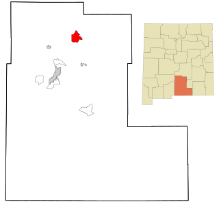
Mescalero is a census-designated place (CDP) in Otero County, New Mexico, United States, located on the Mescalero Apache Reservation. The population was 1,338 at the 2010 census.

Sanostee is a census-designated place (CDP) in San Juan County, New Mexico, United States. The population was 429 at the 2000 census. It is part of the Farmington Metropolitan Statistical Area.
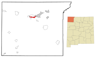
Upper Fruitland is a census-designated place (CDP) in San Juan County, New Mexico, United States. The population was 1,664 at the 2000 census. It is part of the Farmington Metropolitan Statistical Area.

San Felipe Pueblo is a census-designated place (CDP) in Sandoval County, New Mexico, United States, and is located 10 miles (16 km) north of Bernalillo. As of the 2000 census, the CDP population was 2,080. It is part of the Albuquerque Metropolitan Statistical Area.

Ranchos de Taos is a census-designated place (CDP) in Taos County, New Mexico. The population was 2,390 at the time of the 2000 census.
Lincoln Beach is a census-designated place (CDP) in Lincoln County, Oregon, United States. It includes the unincorporated communities of Lincoln Beach and Gleneden Beach. The total population was 2,045 at the 2010 census.

Rose Lodge is a census-designated place (CDP) and unincorporated community in Lincoln County, Oregon, United States, along the 45th parallel. The population was 1,894 at the 2010 census.

Cashtown is a census-designated place in Franklin Township, Adams County, Pennsylvania, United States. The community was part of the Cashtown-McKnightstown CDP, until it was split into two separate CDPs for the 2010 census. As of 2020, the population of Cashtown was 453.
Shindler is an unincorporated community and census-designated place (CDP) in Lincoln County, South Dakota, United States. The population was 607 at the 2020 census.

Juliustown is an unincorporated community and census-designated place (CDP) located within Springfield Township, in Burlington County, in the U.S. state of New Jersey, that was established as part of the 2010 United States census. As of the 2010 Census, the CDP's population was 429.

Caln is a census-designated place (CDP) in Caln Township, Chester County, Pennsylvania, United States. The population was 1,519 at the 2010 census. It is located east of the city of Coatesville and lies west of Philadelphia.

Lincoln University is a census-designated place (CDP) in Lower Oxford Township, Chester County, Pennsylvania, United States. It is located just off campus to Lincoln University, approximately four miles (6.4 km) northeast of the borough of Oxford. The CDP is located near U.S. Route 1. As of the 2010 census, the population was 1,726 residents.
Middle Mesa is a census-designated place (CDP) in San Juan County, New Mexico, United States. It was first listed as a CDP following the 2010 census, replacing the Young Place CDP. At the 2010 census, Young Place had a population of 187.
Cranford is a census-designated place (CDP) comprising the downtown part of Cranford Township, Union County, in the U.S. state of New Jersey. It was first listed as a CDP prior to the 2020 census with a population of population was 2,032.
Paa-Ko is a census-designated place (CDP) in Bernalillo County, New Mexico, United States, built around the Paa-Ko Ridge Golf Club. It was first listed as a CDP prior to the 2020 census.
Angustura is an unincorporated community and census-designated place (CDP) in San Juan County, New Mexico, United States. It was first listed as a CDP prior to the 2020 census.
Center Point is an unincorporated community and census-designated place (CDP) in San Juan County, New Mexico, United States. It was first listed as a CDP prior to the 2020 census.
Crouch Mesa is an unincorporated community and census-designated place (CDP) in San Juan County, New Mexico, United States. It was first listed as a CDP prior to the 2020 census.
Turley is an unincorporated community and census-designated place (CDP) in San Juan County, New Mexico, United States. It was first listed as a CDP prior to the 2020 census.
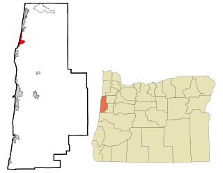
Bayshore is an unincorporated community and census-designated place (CDP) in Lincoln County, Oregon, United States. It was first listed as a CDP prior to the 2020 census.


