
The Yaquina River is a stream, 59 miles (95 km) long, on the Pacific coast of the U.S. state of Oregon. It drains an area of the Central Oregon Coast Range west of the Willamette Valley near Newport.
The Salmon River flows from the Central Oregon Coast Range to the Pacific Ocean coast of northwest Oregon in the United States. About 24 miles (39 km) long, it begins and ends in Lincoln County but also flows briefly through western Polk and southern Tillamook counties. Much of its course lies within the Siuslaw National Forest.
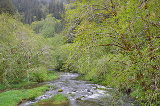
The Nestucca River flows for about 57 miles (92 km) through forests near the Pacific coast of northwest Oregon in the United States. It drains a timber-producing area of the Northern Oregon Coast Range west of Portland.

Agate Beach is an unincorporated community in Lincoln County, Oregon, United States. Agate Beach is named for the agates that are found on the beaches of the Pacific Ocean between Newport and Yaquina Head. Agate Beach post office was established in 1912 and closed in 1971.

Seal Rock is an unincorporated coastal community in Lincoln County, Oregon, United States, between Newport and Waldport on U.S. Route 101.

Chitwood is an unincorporated community in Lincoln County, Oregon, United States. Chitwood lies on U.S. Route 20 between Toledo to the west and Eddyville to the east. The Yaquina River flows through Chitwood.

Service Creek is an unincorporated community in Wheeler County, in the U.S. state of Oregon. Service Creek lies on Oregon Route 19 near its intersection with Oregon Route 207. It is also near the mouth of a stream, Service Creek, formerly Sarvis Creek, that empties into the John Day River.

Beverly Beach is an unincorporated community in Lincoln County in the U.S. state of Oregon. It is located on U.S. Route 101 on the Oregon Coast, north of Yaquina Head and south of Beverly Beach State Park.

Rice Hill is an unincorporated community in Douglas County, Oregon, United States. It is located about 10 miles (16 km) north of Oakland on Interstate 5.

Wilkesboro is an unincorporated community in Washington County, Oregon, United States. It is located on Oregon Route 6, one mile east of Banks.

Blakeley is an unincorporated historic community in Umatilla County, Oregon, United States between Pendleton and Milton-Freewater. It is just north of Oregon Route 11 on Wildhorse Creek. Blakeley was once a station on the Union Pacific Railroad. The station was first named "Eastland" after Robert E. Eastland, who received a patent on land nearby in 1880. The name was later changed to honor William M. Blakley, an Oregon state representative from 1902–1906, and a wheat grower in the area. The elevation is 1417 ft above sea level.
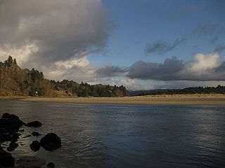
Yaquina, at one time a thriving port called Yaquina City, is an unincorporated community in Lincoln County, in the U.S. state of Oregon. It is near the mouth of the Yaquina River, on the east side of Yaquina Bay, and is a 3-to-4-mile drive from Newport. The Oregon Press Association, which became the Oregon Newspaper Publishers Association, was founded in Yaquina City in 1887.
Manhattan Beach is an unincorporated community in Tillamook County, Oregon, United States. It lies about a mile north of Rockaway Beach along U.S. Route 101. Manhattan Beach State Recreation Site is nearby.
McLeod is an unincorporated community in Jackson County, Oregon, United States. It lies at the confluence of Big Butte Creek with the Rogue River just downstream of Lost Creek Lake. It is along Oregon Route 234 between Shady Cove and Prospect. The community was named after its 1910 settler William R. McLeod.

Elk City is an unincorporated city in Lincoln County, in the U.S. state of Oregon. Lying along the Yaquina River east of Newport, it is on Elk City Road off U.S. Route 20 at Toledo. Elk City lies at the confluence of Big Elk Creek with the river, about 23 miles (37 km) upstream from the Yaquina river mouth. Ocean tides affect the water levels this far upriver.

The Chitwood Bridge is a covered bridge in Lincoln County in the U.S. state of Oregon. The bridge carries Chitwood Road, off U.S. Route 20, over the Yaquina River at Chitwood. The structure was added to the National Register of Historic Places in 1979.
Deadwood Creek is a tributary of Lake Creek in the Siuslaw River basin in Lane County in the U.S. state of Oregon. Beginning near Taylor Butte in the Central Oregon Coast Range, it meanders generally southwest through the Siuslaw National Forest to meet the larger creek at the rural community of Deadwood. This is 5 miles (8 km) from Lake Creek's confluence with the river near Swisshome and 34 miles (55 km) by water from the Siuslaw River's mouth on the Pacific Ocean at Florence.
Hemlock is an unincorporated community in Tillamook County, in the U.S. state of Oregon. It lies along U.S. Route 101 about 3 miles (5 km) north of Beaver. Beaver Creek, a tributary of the Nestucca River, flows through Hemlock.
Watseco is an unincorporated community in Tillamook County, Oregon, United States. It is near two other unincorporated communities in Tillamook County, Barview and Twin Rocks. The three communities are all along a 3-mile (5 km) stretch of U.S. Route 101 between the cities of Rockaway Beach and Garibaldi.
Bitter Lick is an unincorporated community in Jackson County, Oregon, United States. It lies at the confluence of Bitter Lick Creek and Elk Creek, northwest of the ghost town of Persist. Bitter Lick is in the northern part of the county, north of Lost Creek Lake, a reservoir on the Rogue River.


