
Lincoln County is one of the 36 counties in the U.S. state of Oregon. As of the 2020 census, its population was 50,395. The county seat is Newport. The county is named for Abraham Lincoln, 16th president of the United States.

Bayshore Gardens is a census-designated place (CDP) and planned community in Manatee County, Florida, United States. The population was 16,323 at the 2010 census. It is part of the Bradenton–Sarasota–Venice Metropolitan Statistical Area.
Lincoln Beach is a census-designated place (CDP) in Lincoln County, Oregon, United States. It includes the unincorporated communities of Lincoln Beach and Gleneden Beach. The total population was 2,045 at the 2010 census.
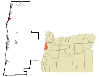
Waldport is a city in Lincoln County, Oregon, United States. The population was 2,033 at the 2010 census. The city is located on the Alsea River and Alsea Bay, 15 miles (24 km) south of Newport and 8 miles (13 km) north of Yachats.

Yachats is a small coastal city in the southernmost area of Lincoln County, Oregon, United States. According to Oregon Geographic Names, the name comes from the Siletz language and means "dark water at the foot of the mountain". There is a range of differing etymologies, however. William Bright says the name comes from the Alsea placename yáx̣ayky. At the 2010 census, the city's population was 690. In 2007, Budget Travel magazine named Yachats one of the "Ten Coolest Small Towns of the U.S.A.", and Yachats was chosen among the top 10 U.S. up-and-coming vacation destinations by Virtualtourist. In 2015, Arthur Frommer, founder of Frommer's Travel Guides, listed Yachats number eight among his ten favorite vacation destinations in the world.

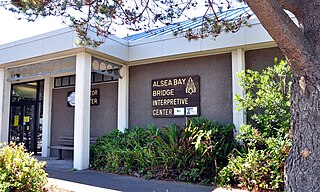
The Alsea River flows 48.5 miles (78.1 km) from Alsea, an unincorporated community in the coastal mountains of the U.S. state of Oregon, to the Pacific Ocean near the city of Waldport. It begins at the confluence of the North Fork Alsea River and the South Fork Alsea River and ends in Alsea Bay, a wide estuary at Waldport. The river flows generally west-northwest in a winding course through the mountains of southern Benton and Lincoln counties, passing near the unincorporated community of Tidewater and through the Siuslaw National Forest. Its drainage basin extends into Lane County, along the headwaters of the South Fork Alsea River.

Dollar Bay is a census-designated place (CDP) in Houghton County, Michigan, United States. The population was 1,082 at the 2010 census.
Pompton Plains is a census-designated place (CDP) comprising the majority of Pequannock Township, Morris County, New Jersey, United States. It is in the valley of the Pompton River, which forms the eastern border of the community, the township, and Morris County. Across the river to the east is Wayne Township in Passaic County, and across the river to the northeast is the borough of Pompton Lakes. Neighboring communities in Morris County are Riverdale to the north, Kinnelon to the west, Lincoln Park to the southwest, and the remainder of Pequannock Township to the south.

Bainbridge is an unincorporated community and census-designated place (CDP) in Conoy Township, Lancaster County, Pennsylvania, United States, with a ZIP code of 17502. Bainbridge is located along Pennsylvania Route 441. As of the 2010 census the population was 1,355.
Shindler is an unincorporated community and census-designated place (CDP) in Lincoln County, South Dakota, United States. The population was 607 at the 2020 census.

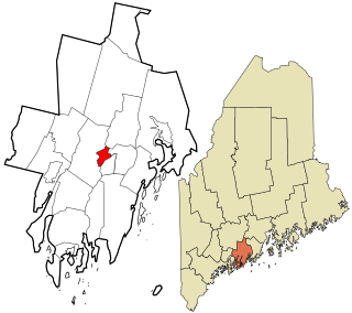
Damariscotta is a census-designated place (CDP) comprising the main village of the town of Damariscotta in Lincoln County, Maine, United States. The population was 1,142 at the 2010 census, out of 2,218 in the entire town. In the 2000 census, the village was part of the Damariscotta-Newcastle CDP.
Newcastle is a census-designated place (CDP) comprising the main village of the town of Newcastle in Lincoln County, Maine, United States. The population was 667 at the 2010 census, out of 1,752 in the entire town. In the 2000 census, the village was part of the Damariscotta-Newcastle CDP.
Fort Loudon (CDP) is an unincorporated community and census-designated place (CDP) in Peters Township, Franklin County, Pennsylvania, United States. As of the 2010 census the population was 886.
Soudersburg is an unincorporated community and census-designated place (CDP) in East Lampeter and Leacock townships in Lancaster County, Pennsylvania, United States. As of the 2010 census the population was 540.
White Haven is an unincorporated community and census-designated place (CDP) in Lincoln County, Montana, United States. The population was 577 at the 2010 census.
Nogal is a census-designated place and unincorporated community in Lincoln County, New Mexico, United States. Its population was 96 as of the 2010 census. Nogal has a post office with ZIP code 88341, which opened on November 9, 1880.
Cranford is a census-designated place (CDP) comprising the downtown part of Cranford Township, Union County, New Jersey, United States. It was first listed as a CDP prior to the 2010 census.
Saunders Lake is an unincorporated community and census-designated place (CDP) in Coos County, Oregon, United States. It was first listed as a CDP prior to the 2020 census.
San Marine is an unincorporated community and census-designated place (CDP) in Lincoln County, Oregon, United States. It was first listed as a CDP prior to the 2020 census.
Swift Bird is a census-designated place (CDP) on the Cheyenne River Indian Reservation in Dewey County, South Dakota, United States. It was first listed as a CDP prior to the 2020 census. The population of the CDP was 117 at the 2020 census.


