Special routes of U.S. Route 601

Last updated
US 601.svg
U.S. Route 601
Highway system

A total of at least five special routes of U.S. Route 601 have existed, one of which has been deleted.

Contents

Special routes

Orangeburg truck route

Truck plate.svg

US 601.svg

U.S. Highway 601 Truck

Location Orangeburg, South Carolina
Length5.2 mi [1] (8.4 km)

U.S. Route 601 Truck (US 601 Truck) is a truck route to direct truck traffic to avoid downtown Oranbeburg. The highway travels concurrently with South Carolina Highway 4 (SC 4) on Stonewall Jackson Boulevard, then with US 21/US 178 on Joe S. Jeffords Highway/Whittaker Parkway/Chestnut Street. [1]

The entire route is in Orangeburg County.

Locationmi [1] kmDestinationsNotes
Orangeburg 0.00.0US 301.svgUS 601.svgSouth Carolina 4.svg US 301 / US 601 / SC 4 west (John C. Calhoun Drive) Allendale, Hampton Southern end of SC 4 concurrency; southern terminus
1.93.1Business plate.svgNo image wide.svg
US 21.svgUS 21.svg US 21 Bus. north / US 21 south (Rowesville Road) Rowesville, Branchville, Walterboro, Savannah, Methodist Oaks
Northern end of SC 4 concurrency; southern end of US 21 concurrency; southern terminus of US 21 Bus.; eastern terminus of SC 4
Wilkinson Heights 2.03.2No image.svgBusiness plate.svgNo image.svgNo image wide.svg
US 178.svgUS 178.svg US 178 Bus. west (Charleston Highway) / US 178 east Charleston, Southern Methodist College
Southern end of US 178 concurrency; eastern terminus of US 178
3.35.3US 301.svg US 301 (Five Chop Road) Orangeburg, Santee
4.47.1South Carolina 33.svg SC 33 (Russell Street) Orangeburg, Cameron
Orangeburg 5.28.4Business plate.svgNo image wide.svg
US 21.svgUS 601.svg US 21 Bus. south / US 601 south (Magnolia Street) Orangeburg
US 21.svgUS 178.svg US 21 north / US 178 west (Chestnut Street) North
US 601.svgI-26.svgHospital sign.svg US 601 north (Magnolia Street) to I-26  St. Matthews, Columbia
Northern end of US 21 and US 178 concurrencies; northern terminus of US 21 Bus.; US 601 north provides access to Regional Medical Center.
1.000 mi = 1.609 km; 1.000 km = 0.621 mi

Camden truck route

Truck plate.svg

US 601.svg

U.S. Highway 601 Truck

Location Camden, South Carolina
Length3.980 mi [2] (6.405 km)

U.S. Route 601 Truck (US 601 Truck) is a 3.980-mile (6.405 km) truck route for truck traffic to avoid downtown Camden. The highway is in complete concurrency with US 521 Truck on Springdale Drive and Boykin Road. [3]

The entire route is in Camden, Kershaw County.

mikmDestinationsNotes
0.0000.000No image wide.svgNo image wide.svgNo image.svgTruck plate.svgNo image.svg
US 1.svgUS 601.svgUS 521.svg US 1 / US 601 / US 521 Truck south (West DeKalb Street)
Southern end of US 521 truck concurrency
3.5005.633South Carolina 97.svg SC 97 (Liberty Hill Road)
3.9806.405US 521.svgUS 601.svg US 521 / US 601 (Kershaw Road)Northern end of US 521 Truck concurrency; northern terminus of US 521 Truck and US 601 Truck
1.000 mi = 1.609 km; 1.000 km = 0.621 mi

Kershaw business loop

Business plate.svg

US 601.svg

U.S. Highway 601 Business

Location Kershaw, South Carolina
Length0.760 mi [4] (1.223 km)

U.S. Route 601 Business (US 601 Bus.) is a business route of US 601 that follows the original mainline of US 601 along Hampton Street. The highway is completely concurrent with US 521 Bus. [5]

The entire route is in Kershaw, Lancaster County.

mi [4] kmDestinationsNotes
0.0000.000US 521.svgUS 601.svg US 521 / US 601 (Hampton Street) – Carolina Motorsports ParkSouthern end of US 521 Bus. concurrency; southern terminus of US 521 Bus. and US 601 Bus.
0.4800.772South Carolina 341.svg SC 341 south (Marion Street) Bethune Northern terminus of SC 341
0.7601.223Hilton Street (US 521 Truck south / US 601 / SC 157 Truck / SC 341 Truck) Jefferson, Pageland Northern end of US 521 Bus. concurrency; northern terminus of US 521 Truck and US 601 Bus.
1.000 mi = 1.609 km; 1.000 km = 0.621 mi

Dobson business loop

Business plate.svg

US 601.svg

U.S. Highway 601 Business

Location Dobson, North Carolina
Length4.1 mi [6] (6.6 km)
Existed1970–present

U.S. Route 601 Business, established in 1970, is a 4.1-mile (6.6 km) business loop that follows the original mainline route through downtown Dobson, via Main Street. [7] [8]

The entire route is in Surry County.

Locationmi [6] kmDestinationsNotes
Dobson 0.00.0US 601.svg US 601  Mount Airy, Yadkinville
4.16.6US 601.svg US 601  Mount Airy, Yadkinville
1.000 mi = 1.609 km; 1.000 km = 0.621 mi

Former special routes

Concord business loop

Business plate.svg

US 601.svg

U.S. Highway 601 Business

Location Concord, North Carolina
Length5.2 mi [9] (8.4 km)
Existed1965–1997

U.S. Route 601 Business was established in October 1965 and followed the original route through downtown Concord, via Church and Union Streets and in concurrency with NC 73. In July 1997, the business loop was decommissioned [7] [8] [10]

Related Research Articles

U.S. Route 601 (US 601) is a north–south United States highway that runs for 316.3 miles (509.0 km) from U.S. Route 321, near Tarboro, South Carolina, to U.S. Route 52, in Mount Airy, North Carolina. In North Carolina, it is one of the main north-south corridors connecting the cities of Salisbury, Mocksville, and Mount Airy.

South Carolina Highway 160

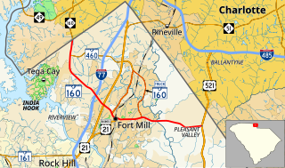
South Carolina Highway 160 (SC 160) is a 11.040-mile (17.767 km) primary state highway in the U.S. state of South Carolina. It travels from North Carolina state line, through Fort Mill, ending in Indian Land.

South Carolina Highway 9

South Carolina Highway 9 (SC 9) is a 259.570-mile (418 km) major state highway in the U.S. state of South Carolina. The highway travels from Cherry Grove Beach to the North Carolina state line upstate. The highway is currently the longest state highway in South Carolina. It is signed as a north–south highway, even though it travels in an east–west direction.

South Carolina Highway 6

South Carolina Highway 6 (SC 6) is a 116.092-mile (186.832 km) state highway in the U.S. state of South Carolina. It extends from US 76 in Ballentine to US 52/SC 6 Truck in Moncks Corner. It uniquely links all three of the major hydropower projects in South Carolina: Lake Murray, Lake Marion, and Lake Moultrie.

South Carolina Highway 34

South Carolina Highway 34 (SC 34) is a 185.930-mile (299.225 km) primary state highway in the U.S. state of South Carolina. As one of the longer state highways, it traverses the state east-west from Greenwood to Dillon, connecting the cities of Newberry, Winnsboro, Camden, Bishopville and Darlington.

Several special routes of U.S. Route 1 exist, from Florida to Maine. In order from south to north, separated by type, these special routes are as follows.

U.S. Route 76 in South Carolina

U.S. Route 76 (US 76) is an east–west U.S. highway in the U.S. state of South Carolina. Being one of the longest highways in the state, it connects the cities of Anderson, Columbia, Sumter and Florence.

U.S. Route 301 in South Carolina

U.S. Route 301 (US 301) is a 189.704-mile (305.299 km) U.S. Highway that travels north–south from the Savannah River southwest of Allendale to Hamer approaching the South of the Border roadside attraction complex.

Several special routes of U.S. Route 52 exist, from North Dakota to South Carolina. In order from northwest to southeast, they are as follows.

South Carolina Highway 151

South Carolina Highway 151 (SC 151) is a 52.850-mile (85.054 km) primary state highway in the U.S. state of South Carolina. Known as "the road to the beach" by many residents of the Charlotte metropolitan area due to it being the most direct route to the Grand Strand, it connects the Charlotte metropolitan area to Darlington, Florence, and the aforementioned Grand Strand.

South Carolina Highway 4

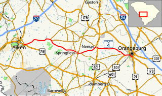
South Carolina Highway 4 (SC 4) is a 54.430-mile-long (87.597 km) state highway in the southern part of the U.S. state of South Carolina. The highway connects Aiken and Orangeburg, via Springfield and Neeses.

Several special routes of U.S. Route 29 exist. In order from south to north they are as follows.

Several special routes of U.S. Route 25 exist. In order from south to north they are as follows.

South Carolina Highway 47 Highway in South Carolina

South Carolina Highway 47 (SC 47) is a 5.740-mile (9.238 km) primary state highway in the U.S. state of South Carolina. It serves to connect the town of Elloree with U.S. Route 301 (US 301).

Several special routes of U.S. Route 21 exist. In order from south to north they are as follows.

Several special routes of U.S. Route 701 exist, from South Carolina to North Carolina. In order from south to north, separated by type, they are as follows.

South Carolina Highway 97

South Carolina Highway 97 (SC 97) is a 89.800-mile (144.519 km) state highway in the U.S. state of South Carolina. The highway connects Camden, Great Falls, Chester, and Hickory Grove.

Four special routes of U.S. Route 521 exist, and two others have existed in the past. In order from south to north they are as follows.

South Carolina Highway 157

South Carolina Highway 157 (SC 157) is a 10.210-mile-long (16.431 km) state highway in the Sandhills region of the U.S. state of South Carolina. Though it physically travels west to east, it is signed as a north–south highway. Its southern terminus is at SC 346 about two miles (3.2 km) west of Catarrh. Its northern terminus is at SC 341 in Kershaw. This is also the southern terminus of SC 157 Truck and SC 341 Truck.

South Carolina Highway 341 Highway in South Carolina

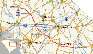
South Carolina Highway 341 (SC 341) is a 93.870-mile (151.069 km) state highway that travels through the northeastern part of the U.S. state of South Carolina. It travels diagonally from the southeast to northwest from SC 41 and SC 51 in Johnsonville to U.S. Route 521 Business and US 601 Bus. in Kershaw.

References

  1. 1 2 3 Google (December 13, 2020). "Overview map of US 601 Truck (Orangeburg, South Carolina)" (Map). Google Maps . Google. Retrieved December 13, 2020.
  2. "Highway Logmile Report". South Carolina Department of Transportation. Retrieved December 13, 2020.
  3. Google (January 26, 2013). "Overview map of US 601 Truck (Camden, South Carolina)" (Map). Google Maps. Google. Retrieved January 26, 2013.
  4. 1 2 "Highway Logmile Report". South Carolina Department of Transportation. Retrieved December 13, 2020.
  5. Google (January 26, 2013). "Overview map of US 601 Bus. (Kershaw, South Carolina)" (Map). Google Maps. Google. Retrieved January 26, 2013.
  6. 1 2 Google (February 16, 2011). "US 601 Bus - Dobson" (Map). Google Maps . Google. Retrieved February 16, 2011.
  7. 1 2 "US 601 Route Change (1965-10-08)" (PDF). North Carolina Department of Transportation. October 8, 1965. Retrieved January 27, 2013.
  8. 1 2 "NCRoads.com: U.S. 601" . Retrieved January 28, 2013.[ unreliable source ]
  9. Google (January 27, 2013). "US 601 Business - Concord, NC" (Map). Google Maps . Google. Retrieved January 27, 2013.
  10. "US 601 Route Change (1997-07-25)" (PDF). North Carolina Department of Transportation. July 25, 1997. Retrieved January 27, 2013.