
Yellow Medicine County is a county in the state of Minnesota. Its eastern border is formed by the Minnesota River. As of the 2020 census, the population was 9,528. Its county seat is Granite Falls.

Cottonwood County is a county in the U.S. state of Minnesota. As of the 2020 census, the population was 11,517. Its county seat is Windom.
Swede Prairie Township is a township in Yellow Medicine County, Minnesota, United States. The population was 162 at the 2000 census.

This is a list of sites in Minnesota which are included in the National Register of Historic Places. There are more than 1,700 properties and historic districts listed on the NRHP; each of Minnesota's 87 counties has at least 2 listings. Twenty-two sites are also National Historic Landmarks.
Purcell & Elmslie (P&E) was the most widely know iteration of a progressive American architectural practice. P&E was the second most commissioned firm of the Prairie School, after Frank Lloyd Wright. The firm in all iterations was active from 1907 to 1921, with their most famous work being done between 1913 and 1921.

Minnehaha Grange, No. 398 was organized on December 23, 1873, with members from Edina Mills, Richfield Mills, St. Louis Park, and Hopkins. The National Grange of the Order of Patrons of Husbandry, commonly known as the Grange, is an organization dedicated to the principles of "progressive agriculture" for the "social fraternity of the farmers". The organization was founded in 1867 by Oliver Hudson Kelley in Elk River, Sherburne County, Minnesota and quickly spread across the country. The fraternity tackled issues such as railroad prices, and providing education to farmers.

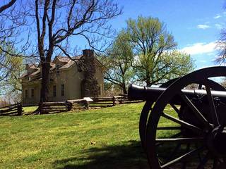
The Andrew John Volstead House is the historic house in Granite Falls, Minnesota, of ten-term United States Congressman Andrew Volstead (1860–1947). It is now managed as a museum and the organizational headquarters of the Granite Falls Historical Society. Volstead became nationally synonymous with Prohibition in 1919 when, as chairman of the House Judiciary Committee, he was obliged to author the Volstead Act, enabling enforcement of the recently ratified Eighteenth Amendment. Volstead was a moderate progressive who coauthored the Capper–Volstead Act in 1922, which legalized agricultural cooperatives.

This is a list of the National Register of Historic Places listings in Dakota County, Minnesota. It is intended to be a complete list of the properties and districts on the National Register of Historic Places in Dakota County, Minnesota, United States. Dakota County is located in the southeastern part of the U.S. state of Minnesota, bounded on the northeast side by the Upper Mississippi River and on the northwest by the Minnesota River. The locations of National Register properties and districts for which the latitude and longitude coordinates are included below, may be seen in an online map.

This is a list of the National Register of Historic Places listings in Carver County, Minnesota. It is intended to be a complete list of the properties and districts on the National Register of Historic Places in Carver County, Minnesota, United States. The locations of National Register properties and districts for which the latitude and longitude coordinates are included below, may be seen in an online map.

This is a list of the National Register of Historic Places listings in Le Sueur County, Minnesota. It is intended to be a complete list of the properties and districts on the National Register of Historic Places in Le Sueur County, Minnesota, United States. The locations of National Register properties and districts for which the latitude and longitude coordinates are included below, may be seen in an online map.

This is a list of the National Register of Historic Places listings in Wright County, Minnesota. It is intended to be a complete list of the properties and districts on the National Register of Historic Places in Wright County, Minnesota, United States. The locations of National Register properties and districts for which the latitude and longitude coordinates are included below, may be seen in an online map.

This is a list of the National Register of Historic Places listings in Todd County, Minnesota. It is intended to be a complete list of the properties and districts on the National Register of Historic Places in Todd County, Minnesota, United States. The locations of National Register properties and districts for which the latitude and longitude coordinates are included below, may be seen in an online map.

This is a list of the National Register of Historic Places listings in Steele County, Minnesota. It is intended to be a complete list of the properties and districts on the National Register of Historic Places in Steele County, Minnesota, United States. The locations of National Register properties and districts for which the latitude and longitude coordinates are included below, may be seen in an online map.
The Prairie Grove Battlefield State Park is a state park located in Prairie Grove, Arkansas. It memorializes the Battle of Prairie Grove, fought on December 7, 1862, during the American Civil War. The battle secured U.S. Army control of northwestern Arkansas.

The Grange Hall in Somerset Township, Jackson County, Illinois, is the historic meeting place of Somerset Township's chapter of The Grange. Built in 1912, the building was Somerset Grange #1553's second meeting hall; the first building was built in 1876 and burned down in 1909. The red brick building was built by contractor W. A. Pitman in the Commercial style. The Grange Hall served as a meeting place for local farmers to discuss agricultural affairs and propose farm policy to legislators. The National Farmers Union's newspaper, the Union Farmer, was published from the Somerset Grange Hall until 1914. The building also served as a local social center and hosted township elections, club meetings, and community events. The hall was rehabilitated in 1988; it still serves as a township polling place.
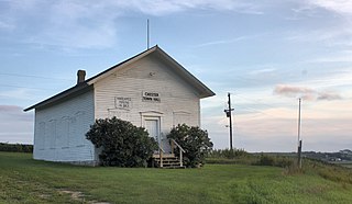
The Bear Valley Grange Hall is a historic meeting hall in Chester Township, Minnesota, United States. It was built in 1874 for the exclusive use of a local chapter of the National Grange of the Order of Patrons of Husbandry, an early farmers' advocacy group and fraternal organization. The chapter folded in the 1880s and the building has been used since as the Chester Town Hall. It was listed on the National Register of Historic Places in 1989 for having local significance in the theme of social history. It was nominated for being the only surviving Grange hall in Wabasha County—and one of only a few in Minnesota—and a rare example of a purpose-built Grange hall, as most chapters met in existing spaces like schools.

Crescent Grange Hall #512 is a former meeting hall of the Grange agricultural society in Linwood Township, Minnesota, United States. It was built from 1881 to 1882 by a chapter of the State Grange of Minnesota, the first state-level subdivision of the National Grange. It was listed on the National Register of Historic Places in 1979 for its local significance in the themes of agriculture and social history. It was nominated for being a well preserved example of an early meeting hall built by a subordinate Grange.

This is a list of the National Register of Historic Places listings in Lac qui Parle County, Minnesota. It is intended to be a complete list of the properties and districts on the National Register of Historic Places in Lac qui Parle County, Minnesota, United States. The locations of National Register properties and districts for which the latitude and longitude coordinates are included below, may be seen in an online map.
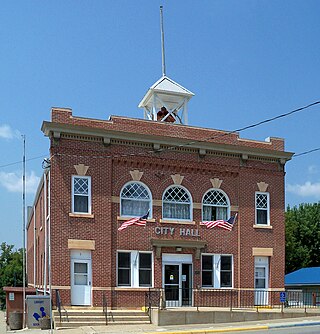
Kimball City Hall is the seat of local government for Kimball, Minnesota, United States. It was built in 1908 when the community was still a village known as Kimball Prairie. When it first opened the hall housed offices for local government, professionals, and the telephone utility, as well as a public library and a municipal theater. The building was listed on the National Register of Historic Places in 1982 as Kimball Prairie Village Hall for its local significance in the theme of politics/government. It was nominated for embodying the importance the community placed on local government and public services in the early 20th century.

The Drammen Farmers' Club is a meeting hall built in 1921 by a purely social club to host events for a sparsely populated agricultural community in Drammen Township, Lincoln County, Minnesota, United States. After long service as a local community center, it was listed on the National Register of Historic Places in 1980 and became the town hall for the township.


