Big River, California | |
---|---|
Coordinates: 34°8′2″N114°22′11″W / 34.13389°N 114.36972°W | |
Country | United States |
State | California |
County | San Bernardino |
Area | |
• Total | 11.35 sq mi (29.40 km2) |
• Land | 10.83 sq mi (28.05 km2) |
• Water | 0.52 sq mi (1.34 km2) 4.60% |
Elevation | 436 ft (133 m) |
Population (2020) | |
• Total | 1,084 |
• Density | 100.08/sq mi (38.64/km2) |
Time zone | UTC-8 (PST) |
• Summer (DST) | UTC-7 (PDT) |
ZIP code | 92242 |
Area codes | 442/760 |
FIPS code | 06-06635 |
GNIS feature ID | 1866999 |
Big River is a census-designated place (CDP) in San Bernardino County, California, United States. The population was 1,084 at the 2020 census, down from 1,327 at the 2010 census.
Big River is located on the west bank of the Colorado River at 34°8′2″N114°22′11″W / 34.13389°N 114.36972°W (34.134021, -114.369782). [2]
According to the United States Census Bureau, the CDP has a total area of 11.4 square miles (30 km2). 10.8 square miles (28 km2) of it is land and 0.5 square miles (1.3 km2) of it (4.60%) is water.
Parks in Big River are administered by the Big River Community Service District [3]
Census | Pop. | Note | %± |
---|---|---|---|
2000 | 1,266 | — | |
2010 | 1,327 | 4.8% | |
2020 | 1,084 | −18.3% | |
U.S. Decennial Census [4] |
At the 2010 census Big River had a population of 1,327. The population density was 116.9 inhabitants per square mile (45.1/km2). The racial makeup of Big River was 1,137 (85.7%) White (79.5% Non-Hispanic White), [5] 14 (1.1%) African American, 50 (3.8%) Native American, 2 (0.2%) Asian, 0 (0.0%) Pacific Islander, 54 (4.1%) from other races, and 70 (5.3%) from two or more races. Hispanic or Latino of any race were 160 people (12.1%). [6]
The whole population lived in households, no one lived in non-institutionalized group quarters and no one was institutionalized.
There were 640 households, 116 (18.1%) had children under the age of 18 living in them, 268 (41.9%) were opposite-sex married couples living together, 67 (10.5%) had a female householder with no husband present, 38 (5.9%) had a male householder with no wife present. There were 44 (6.9%) unmarried opposite-sex partnerships, and 9 (1.4%) same-sex married couples or partnerships. 216 households (33.8%) were one person and 134 (20.9%) had someone living alone who was 65 or older. The average household size was 2.07. There were 373 families (58.3% of households); the average family size was 2.56.
The age distribution was 192 people (14.5%) under the age of 18, 68 people (5.1%) aged 18 to 24, 174 people (13.1%) aged 25 to 44, 429 people (32.3%) aged 45 to 64, and 464 people (35.0%) who were 65 or older. The median age was 54.9 years. For every 100 females, there were 100.8 males. For every 100 females age 18 and over, there were 98.4 males.
There were 1,064 housing units at an average density of 93.7 per square mile, of the occupied units 509 (79.5%) were owner-occupied and 131 (20.5%) were rented. The homeowner vacancy rate was 3.8%; the rental vacancy rate was 34.1%. 1,009 people (76.0% of the population) lived in owner-occupied housing units and 318 people (24.0%) lived in rental housing units.
According to the 2010 United States Census, Big River had a median household income of $29,063, with 11.8% of the population living below the federal poverty line. [7]
At the 2000 census there were 1,266 people, 570 households, and 369 families in the CDP. The population density was 116.0 inhabitants per square mile (44.8/km2). There were 1,053 housing units at an average density of 96.5 per square mile (37.3/km2). The racial makeup of the CDP was 84.9% White, 2.5% African American, 2.5% Native American, 1.0% Asian, 6.3% from other races, and 2.8% from two or more races. Hispanic or Latino of any race were 9.6%. [8]
Of the 570 households 17.2% had children under the age of 18 living with them, 51.8% were married couples living together, 8.8% had a female householder with no husband present, and 35.1% were non-families. 27.7% of households were one person and 15.8% were one person aged 65 or older. The average household size was 2.22 and the average family size was 2.66.
The age distribution was 19.3% under the age of 18, 4.1% from 18 to 24, 18.6% from 25 to 44, 26.4% from 45 to 64, and 31.7% 65 or older. The median age was 53 years. For every 100 females, there were 91.5 males. For every 100 females age 18 and over, there were 91.7 males.
The median household income was $23,488 and the median family income was $26,250. Males had a median income of $25,000 versus $20,125 for females. The per capita income for the CDP was $13,862. About 13.1% of families and 18.5% of the population were below the poverty line, including 26.3% of those under age 18 and 8.6% of those age 65 or over.
In the California State Legislature, Big River is in the 18th Senate District , represented by Democrat Steve Padilla, and in the 36th Assembly District , represented by Democrat Eduardo Garcia. [9]
In the United States House of Representatives, Big River is in California's 25th congressional district , represented by Democrat Raul Ruiz. [10]
Beluga is a census-designated place (CDP) in Kenai Peninsula Borough, Alaska, United States. The population was 20 at the 2010 census, down from 32 in 2000.
Tobin is a census-designated place (CDP) in Plumas County, California, United States. The population was 12 at the 2010 census, up from 11 at the 2000 census.
Gold River is a census-designated place (CDP) in Sacramento County, California. The population was 7,812 at the 2010 census, down from 8,023 at the 2000 census. Gold River is part of the Sacramento–Arden-Arcade–Roseville Metropolitan Statistical Area. With a median family income of $141,399 according to U.S Census Bureau in 2021, Gold River is the highest-income place in Sacramento County.
East Oakdale is an unincorporated census-designated place (CDP) on the Stanislaus River, located east of the city of Oakdale in Stanislaus County, California.
Vero Beach South is a census-designated place (CDP) in Indian River County, Florida, United States. The population was 23,092 at the 2010 census. It is part of the Sebastian–Vero Beach Metropolitan Statistical Area.
Quinnesec is an unincorporated community in Dickinson County in the U.S. state of Michigan. It is a census-designated place (CDP) for statistical purposes and has no legally recognized status as a municipality. The population was 1,083 at the 2020 census. It is part of the Iron Mountain, MI–WI Micropolitan Statistical Area.
Cedar Hill is an unincorporated community and census-designated place (CDP) in northwest Jefferson County, Missouri, United States. The population was 1,721 at the 2010 census.
Lemay is a census-designated place (CDP) in south St. Louis County, Missouri, United States. The population was 16,645 at the 2010 census.
St. Xavier is an unincorporated community and census-designated place (CDP) in Big Horn County, Montana, United States. The CDP population was 83 at the 2010 census.
Shark River Hills is an unincorporated community and census-designated place (CDP) within Neptune Township, in Monmouth County, in the U.S. state of New Jersey. As of the 2010 United States Census, the CDP's population was 3,697.
Flanders is a hamlet and a census-designated place (CDP) in Suffolk County, New York, United States. The population was 4,472 at the 2010 census. It is the location of the Big Duck.
Big Beaver is a borough in northern Beaver County, Pennsylvania, United States. The population was 1,852 at the 2020 census. It is a part of the Pittsburgh metropolitan area. The area was originally incorporated as Big Beaver Township in 1802, and was reincorporated as a borough in 1958.
East Berwick is a census-designated place (CDP) in Salem Township, Luzerne County, Pennsylvania, United States. The population was 2,007 at the 2010 census.
Lake Morton-Berrydale is a census-designated place (CDP) in King County, Washington, United States. The population was 10,474 at the 2020 census.
Norfolk is a hamlet in St. Lawrence County, New York, United States. The population was 1,327 at the 2010 census.
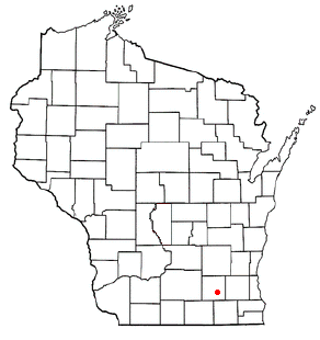
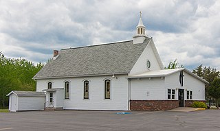
Hebron is a census-designated place (CDP) in the town of Hebron, Jefferson County, Wisconsin, United States. The population was 209 at the 2020 census. It is located on the Bark River.
Fort Kent is a census-designated place (CDP) that comprises the main village in the town of Fort Kent in Aroostook County, Maine, United States. In 2010, Fort Kent's population was 2,488 of 4,097 for the entire town.
Madawaska is a census-designated place (CDP) comprising the main village within the town of Madawaska in Aroostook County, Maine, United States. The population of the CDP was 2,967 at the 2010 census, out of a population of 4,035 for the entire town.
Milo is a census-designated place (CDP) in the town of Milo in Piscataquis County, Maine, United States. The population was 1,898 at the 2000 census.
Skowhegan is a census-designated place (CDP) in the town of Skowhegan in Somerset County, Maine, United States. The population was 6,404 at the 2020 census.