Clayton, Alabama

Last updated

Clayton, Alabama
Clayton Alabama Courthouse Square.JPG
Courthouse Square and Confederate Monument in Clayton
Flag of Clayton, Alabama.png
Barbour County Alabama Incorporated and Unincorporated areas Clayton Highlighted 0115376.svg
Location of Clayton in Barbour County, Alabama.
Coordinates: 31°52′39″N85°26′56″W / 31.87750°N 85.44889°W / 31.87750; -85.44889
Country United States
State Alabama
County Barbour
Area
[1]
  Total6.78 sq mi (17.55 km2)
  Land6.78 sq mi (17.55 km2)
  Water0.00 sq mi (0.00 km2)
Elevation
591 ft (180 m)
Population
 (2020)
  Total2,265
  Density334.27/sq mi (129.06/km2)
Time zone UTC-6 (Central (CST))
  Summer (DST) UTC-5 (CDT)
ZIP code
36016
Area code 334
FIPS code 01-15376
GNIS feature ID0116206

Clayton is a town in and the county seat of Barbour County, Alabama, United States. The population was 3,008 at the 2010 census, [2] up from 1,475 in 2000. [3]

Contents

History

Clayton has been the county seat since 1834, two years after the creation of Barbour County. Clayton is located geographically in the center of the county. The town was located at the headwaters of the Pea and Choctawhatchee rivers on the historic road from Hobdy's Bridge over the Pea River to Eufaula on the Chattahoochee River. By 1818, there were a few settlers in the area around Clayton, but settlement began in earnest around 1823. The town was named for Augustin S. Clayton, a Georgia jurist and congressman. Clayton became the county seat of Barbour County in 1833 and was laid out on a central courthouse square plan. The first Circuit Court was held in Clayton on September 23, 1833. The Clayton post office was established in September 1835 with John F. Keener as postmaster. Clayton, with a population of 200, was incorporated on December 21, 1841, by the Alabama Legislature. Its first mayor, after incorporation, was John Jackson.

Clayton has a rich heritage with four properties listed on the National Register of Historic Places. It is also known for its Whiskey Bottle Tombstone, which was featured in Ripley's Believe It or Not! . [4]

Governor George Wallace was born in nearby Clio and began his legal and political career in Clayton. In March 1956, Wallace attended at the Clayton football stadium the first public meeting of the Barbour County White Citizens' Council, with an estimated 4,500 persons attending the white supremacist rally, "the largest rally in the history of the county seat." [5]

Geography

Clayton is located at 31°52'39.014" North, 85°26'56.486" West (31.877504, -85.449024). [6]

According to the U.S. Census Bureau, the town has a total area of 6.7 square miles (17.3 km2), all land. [2]

Climate

The climate in this area is characterized by hot, humid summers and generally mild to cool winters. According to the Köppen Climate Classification system, Clayton has a humid subtropical climate, abbreviated "Cfa" on climate maps. [7]

Climate data for Clayton, Alabama, 1991–2020 normals, extremes 1956–present
MonthJanFebMarAprMayJunJulAugSepOctNovDecYear
Record high °F (°C)82
(28)
84
(29)
88
(31)
94
(34)
98
(37)
101
(38)
104
(40)
105
(41)
102
(39)
99
(37)
92
(33)
84
(29)
105
(41)
Mean maximum °F (°C)74.0
(23.3)
77.6
(25.3)
83.0
(28.3)
86.2
(30.1)
92.7
(33.7)
95.4
(35.2)
97.3
(36.3)
97.0
(36.1)
94.3
(34.6)
88.3
(31.3)
81.9
(27.7)
75.8
(24.3)
98.3
(36.8)
Mean daily maximum °F (°C)58.3
(14.6)
62.5
(16.9)
69.8
(21.0)
76.5
(24.7)
84.0
(28.9)
88.8
(31.6)
91.3
(32.9)
90.4
(32.4)
86.1
(30.1)
77.9
(25.5)
68.3
(20.2)
60.3
(15.7)
76.2
(24.5)
Daily mean °F (°C)47.7
(8.7)
51.3
(10.7)
57.9
(14.4)
64.4
(18.0)
72.4
(22.4)
78.8
(26.0)
81.3
(27.4)
80.7
(27.1)
76.1
(24.5)
66.7
(19.3)
56.5
(13.6)
50.1
(10.1)
65.3
(18.5)
Mean daily minimum °F (°C)37.0
(2.8)
40.1
(4.5)
46.0
(7.8)
52.4
(11.3)
60.9
(16.1)
68.8
(20.4)
71.4
(21.9)
71.1
(21.7)
66.1
(18.9)
55.4
(13.0)
44.6
(7.0)
39.8
(4.3)
54.5
(12.5)
Mean minimum °F (°C)18.6
(−7.4)
23.4
(−4.8)
27.7
(−2.4)
36.6
(2.6)
44.9
(7.2)
59.0
(15.0)
65.2
(18.4)
62.7
(17.1)
52.5
(11.4)
37.7
(3.2)
27.2
(−2.7)
23.5
(−4.7)
16.7
(−8.5)
Record low °F (°C)−6
(−21)
11
(−12)
13
(−11)
27
(−3)
32
(0)
48
(9)
57
(14)
56
(13)
42
(6)
28
(−2)
17
(−8)
−5
(−21)
−6
(−21)
Average precipitation inches (mm)4.55
(116)
5.23
(133)
5.21
(132)
4.98
(126)
3.70
(94)
4.94
(125)
6.03
(153)
4.54
(115)
3.68
(93)
3.33
(85)
3.83
(97)
5.62
(143)
55.64
(1,412)
Average snowfall inches (cm)0.2
(0.51)
0.0
(0.0)
0.0
(0.0)
0.0
(0.0)
0.0
(0.0)
0.0
(0.0)
0.0
(0.0)
0.0
(0.0)
0.0
(0.0)
0.0
(0.0)
0.0
(0.0)
0.3
(0.76)
0.5
(1.27)
Average precipitation days (≥ 0.01 in)7.88.47.26.55.99.910.09.06.24.35.47.888.4
Average snowy days (≥ 0.1 in)0.40.10.00.00.00.00.00.00.00.00.00.10.6
Source 1: NOAA [8]
Source 2: National Weather Service [9]

Demographics

Historical population
CensusPop.Note
1850 400
1880 761
1890 99731.0%
1900 9980.1%
1910 1,13013.2%
1920 989−12.5%
1930 1,71773.6%
1940 1,8135.6%
1950 1,583−12.7%
1960 1,313−17.1%
1970 1,62623.8%
1980 1,589−2.3%
1990 1,564−1.6%
2000 1,475−5.7%
2010 3,008103.9%
2020 2,265−24.7%
U.S. Decennial Census [10]
2013 Estimate [11]

2020 census

Clayton racial composition [12]
RaceNum.Perc.
White (non-Hispanic)77934.39%
Black or African American (non-Hispanic)1,41362.38%
Asian 20.09%
Other/Mixed 351.55%
Hispanic or Latino 361.59%

As of the 2020 United States census, there were 2,265 people, 569 households, and 359 families residing in the town.

2010 census

As of the census [13] of 2010, there were 3,008 people, 552 households, and 349 families residing in the town. The population density was 450 inhabitants per square mile (170/km2). There were 649 housing units at an average density of 96.8 per square mile (37.4/km2). The racial makeup of the town was 63.8% Black or African American, 35.8% White, 0.0% Native American, 0.0% from other races, and 0.3% from two or more races. .6% of the population were Hispanic or Latino of any race.

There were 552 households, out of which 28.8% had children under the age of 18 living with them, 31.2% were married couples living together, 27.7% had a female householder with no husband present, and 36.8% were non-families. 33.5% of all households were made up of individuals, and 13.1% had someone living alone who was 65 years of age or older. The average household size was 2.33 and the average family size was 2.95.

In the town, the population was spread out, with 11.9% under the age of 18, 11.7% from 18 to 24, 46.1% from 25 to 44, 23.3% from 45 to 64, and 7.1% who were 65 years of age or older. The median age was 34.8 years. For every 100 females, there were 317.2 males. For every 100 females age 18 and over, there were 112.5 males.

The median income for a household in the town was $23,629, and the median income for a family was $17,778. Males had a median income of $33,750 versus $26,964 for females. The per capita income for the town was $11,288. About 27.4% of families and 29.3% of the population were below the poverty line, including 30.6% of those under age 18 and 26.3% of those age 65 or over.


Education

Clayton is served by Barbour County Schools. Barbour County High School and Barbour County Primary School are located in the town of Clayton.

Notable people

Related Research Articles

<span class="mw-page-title-main">Barbour County, Alabama</span> County in Alabama, United States

Barbour County is a county in the southeastern part of the U.S. state of Alabama. As of the 2020 census, the population was 25,223. Its county seat is Clayton. Its largest city is Eufaula. Its name is in honor of James Barbour, who served as Governor of Virginia.

<span class="mw-page-title-main">Henry County, Alabama</span> County in Alabama, United States

Henry County is a county in the southeastern part of the U.S. state of Alabama. As of the 2020 census, its population was 17,146. Its county seat is Abbeville. The county was named for Patrick Henry (1736–1799), famous orator and Governor of Virginia.

<span class="mw-page-title-main">Clio, Alabama</span> City in Alabama, United States

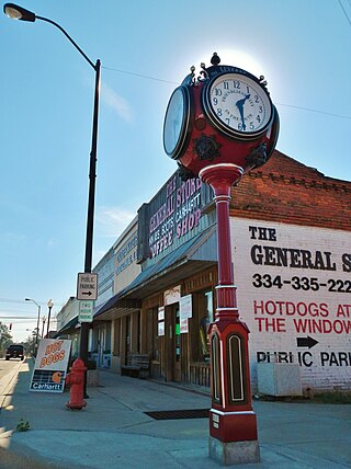
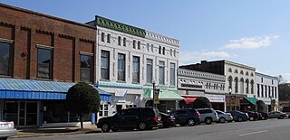
Clio is a city in Barbour County, Alabama, United States. The population was 1,399 at the 2010 census, down from 2,206 in 2000, at which time it was a town. It is the birthplace of former Alabama governor George C. Wallace, as well as Baseball Hall of Famer and former Atlanta Braves broadcaster Don Sutton.

<span class="mw-page-title-main">Eufaula, Alabama</span> City in Alabama, United States

Eufaula is the largest city in Barbour County, Alabama, United States. As of the 2010 census the city's population was 13,137.

<span class="mw-page-title-main">Louisville, Alabama</span> Town in Alabama, United States

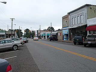
Louisville is a town in Barbour County, Alabama, United States. Originally named "Lewisville" and still pronounced as such. At the 2020 census, the population was 395.

<span class="mw-page-title-main">Midway, Alabama</span> Town in Alabama, United States

Midway is a town located in eastern Bullock County, Alabama, United States. At the 2020 census, the population was 421.

<span class="mw-page-title-main">Greenville, Alabama</span> City in Alabama, United States

Greenville is a city and the county seat of Butler County, Alabama, United States. At the 2020 census, the population was 7,374. Greenville is known as the Camellia City, wherein originated the movement to change the official Alabama state flower from the goldenrod to the camellia with legislative sponsors LaMont Glass and H.B. Taylor.

<span class="mw-page-title-main">LaFayette, Alabama</span> City in Alabama, United States

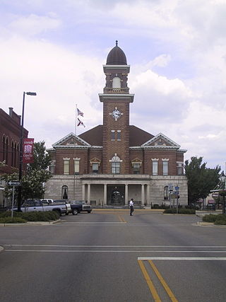
LaFayette is the county seat of Chambers County, Alabama, United States, 47 miles (76 km) northwest of Columbus, Georgia. As of the 2010 census, the population of the city was 3,003.

<span class="mw-page-title-main">Edwardsville, Alabama</span> Town in Alabama, United States

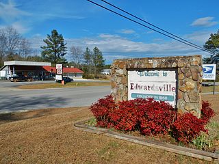
Edwardsville is a town in Cleburne County, Alabama, United States. At the 2020 census, the population was 206. From 1867 to 1906, it served as the Cleburne County Seat. In 1880 and 1890, it was the most populous community in the county. It reached its population zenith of 448 in 1900 when it fell behind Heflin, to which it also lost the county seat to six years later. It has not had more than 226 persons since 1920.

<span class="mw-page-title-main">Andalusia, Alabama</span> City in and county seat of Covington County, Alabama

Andalusia is a city in and the county seat of Covington County, Alabama, United States. At the 2020 census, the population was 8,805.

<span class="mw-page-title-main">Luverne, Alabama</span> City in Alabama, United States

Luverne is a city in and the county seat of Crenshaw County, Alabama, United States. The city describes itself as "The Friendliest City in the South", a slogan that appears on its "welcome" signs. At the 2020 census, the population was 2,765.

<span class="mw-page-title-main">Ozark, Alabama</span> City in Alabama, United States

Ozark is a city in and the county seat of Dale County, Alabama. As of the 2010 census, the population of the city was 14,907.

<span class="mw-page-title-main">Eutaw, Alabama</span> City in and county seat of Greene County, Alabama

Eutaw is a city in and the county seat of Greene County, Alabama, United States. At the 2020 census, the population was 2,937. The city was named in honor of the Battle of Eutaw Springs, the last engagement of the American Revolutionary War in the Carolinas.

<span class="mw-page-title-main">Phenix City, Alabama</span> City in Alabama, United States

Phenix City is a city in Lee and Russell counties in the U.S. state of Alabama, and the county seat of Russell County. As of the 2020 Census, the population of the city was 38,817.

<span class="mw-page-title-main">Athens, Alabama</span> City in and county seat of Limestone County, Alabama

Athens is a city in and the county seat of Limestone County, in the U.S. state of Alabama; it is included in the Huntsville-Decatur-Albertville, AL Combined Statistical Area. As of the 2020 census, the population of the city is 25,406.

<span class="mw-page-title-main">Talladega, Alabama</span> City in Alabama, United States

Talladega is the county seat of Talladega County, Alabama, United States. It was incorporated in 1835. At the 2020 census, the population was 15,861. Talladega is approximately 50 miles (80 km) east of one of the state’s largest cities, Birmingham.

<span class="mw-page-title-main">Alexander City, Alabama</span> City in Alabama, United States

Alexander City, known to locals as "Alex City", is the largest city in Tallapoosa County, Alabama, United States, with a population of 14,843 as of the 2020 census. It has been the largest community in Tallapoosa County since 1910. It is known for Lake Martin with its 750 miles (1,210 km) of wooded shoreline and 44,000 acres (18,000 ha) of water. Lake Martin stands on the Tallapoosa River and offers boating, swimming, fishing, golfing, and camping. Many neighborhoods and luxury homes are located on the lake.

<span class="mw-page-title-main">Dadeville, Alabama</span> County seat of Tallapoosa County

Dadeville is a city in and the county seat of Tallapoosa County, Alabama, United States. At the 2010 census the population was 3,230, up from 3,212 in 2000.

<span class="mw-page-title-main">Camden, Alabama</span> City in and county seat of Wilcox County, Alabama

Camden is a city in and the county seat of Wilcox County, Alabama, United States. The population was 2,020 at the 2010 census, down from 2,257 in 2000, at which time it was a town.

<span class="mw-page-title-main">Brookville, Indiana</span> Town in Indiana, United States

Brookville is a town in Brookville Township, Franklin County, Indiana, United States. The town is the county seat of and the largest community entirely within Franklin County. The population was 2,596 at the 2010 census.

References

  1. "2020 U.S. Gazetteer Files". United States Census Bureau. Retrieved October 29, 2021.
  2. 1 2 "Geographic Identifiers: 2010 Demographic Profile Data (G001): Clayton town, Alabama". U.S. Census Bureau, American Factfinder. Archived from the original on February 12, 2020. Retrieved September 16, 2013.
  3. "Fact Sheet: Clayton town, Alabama". American Fact Finder. United States Census Bureau. Archived from the original on February 16, 2020. Retrieved January 6, 2010.
  4. Small Town Historic Markers, Alabama Tourism Department, archived from the original on February 3, 2011, retrieved October 31, 2011
  5. Carter, Dan T. (1995). The politics of rage : George Wallace, the origins of the new conservatism, and the transformation of American politics. New York: Simon & Schuster. p. 85. ISBN   0-684-80916-8. OCLC   32739924.
  6. "US Gazetteer files: 2010, 2000, and 1990". United States Census Bureau. February 12, 2011. Retrieved April 23, 2011.
  7. Climate Summary for Clayton, Alabama
  8. "U.S. Climate Normals Quick Access – Station: Clayton, AL". National Oceanic and Atmospheric Administration. Retrieved March 4, 2023.
  9. "NOAA Online Weather Data – NWS Birmingham". National Weather Service. Retrieved March 4, 2023.
  10. "U.S. Decennial Census". Census.gov. Retrieved June 6, 2013.
  11. "Annual Estimates of the Resident Population: April 1, 2010 to July 1, 2013" . Retrieved June 3, 2014.
  12. "Explore Census Data". data.census.gov. Retrieved December 13, 2021.
  13. "U.S. Census website". United States Census Bureau . Retrieved July 8, 2015.

31°52′39″N85°26′56″W / 31.877504°N 85.449024°W / 31.877504; -85.449024