Dadeville, Alabama

Last updated

Dadeville, Alabama
Coming into town.jpg
Entering Downtown
Tallapoosa County Alabama Incorporated and Unincorporated areas Dadeville Highlighted 0119336.svg
Location of Dadeville in Tallapoosa County, Alabama.
Coordinates: 32°49′53″N85°45′49″W / 32.83139°N 85.76361°W / 32.83139; -85.76361
Country United States
State Alabama
County Tallapoosa
Named for Francis L. Dade
Area
[1]
  Total16.03 sq mi (41.51 km2)
  Land15.94 sq mi (41.29 km2)
  Water0.09 sq mi (0.22 km2)
Elevation
728 ft (222 m)
Population
 (2020)
  Total3,084
  Density193.46/sq mi (74.70/km2)
Time zone UTC−6 (Central (CST))
  Summer (DST) UTC−5 (CDT)
36853
36853
Area code 256
FIPS code 01-19336
GNIS feature ID0117010
Website www.cityofdadevilleal.org

Dadeville is a city in and the county seat of Tallapoosa County, Alabama, United States. [2] At the 2010 census the population was 3,230, up from 3,212 in 2000.

Contents

History

Prior to its incorporation, Dadeville was an Indian trading post and a center of commerce where commodities such as cotton, lumber, tin, asbestos, and livestock were traded. The town was surveyed by John H. Broadnax in 1836, [3] granted a charter in 1837, and first incorporated in 1858. Dadeville was named for Major Francis Langhorne Dade, [4] who was killed in 1835 by Seminole Indians in a battle of the Second Seminole War that came to be known as the "Dade Massacre". Dade had never actually visited Tallapoosa County. [3]

As a stagecoach stop on the Tennessee Road between Montgomery and Georgia, Dadeville was host to a stream of traders whose goods and livestock often crowded the square of the courthouse. [3] Dadeville lost its charter during the Civil War, and was incorporated a second time in 1878. Dadeville has been the Tallapoosa County seat since 1838. [5]

Dadeville was home to the Graefenberg Medical Institute, Alabama's first medical school, which operated from 1852 until the outbreak of the Civil War. Attempts to revive the school after the war failed, and the building burned in 1873. [6]

The completion of the Martin Dam on the Tallapoosa River in 1926 and the subsequent creation of Lake Martin had and continues to have a strong economic impact on Dadeville. [6]

On April 15, 2023, four people were killed and 32 others were injured in a mass shooting at a party. Most of the victims were teenagers. [7]

Geography

According to the U.S. Census Bureau, the city has a total area of 16.0 square miles (41 km2), all land.

The city is located in the east central part of the state along U.S. Route 280, which runs through the northern part of the city. It leads northwest 15 mi (24 km) to Alexander City and southeast 28 mi (45 km) to Opelika. Birmingham is 85 mi (137 km) northwest via US 280. Alabama State Route 49 also runs through the city from north to south, leading north 18 mi (29 km) to New Site and south 18 mi (29 km) to Reeltown.

Climate

The climate in this area is characterized by hot, humid summers and generally mild to cool winters. According to the Köppen climate classification system, Dadeville has a humid subtropical climate, abbreviated "Cfa" on climate maps. [8]

Demographics

Historical population
CensusPop.Note
1880 740
1890 87318.0%
1900 1,13630.1%
1910 1,1935.0%
1920 1,146−3.9%
1930 1,54935.2%
1940 2,02530.7%
1950 2,35416.2%
1960 2,94024.9%
1970 2,847−3.2%
1980 3,26314.6%
1990 3,2760.4%
2000 3,212−2.0%
2010 3,2300.6%
2020 3,084−4.5%
U.S. Decennial Census [9]
2013 Estimate [10]

2000 census

At the 2000 census there were 3,212 people, 1,122 households, and 813 families living in the city. The population density was 200.7 inhabitants per square mile (77.5/km2). There were 1,278 housing units at an average density of 79.9 per square mile (30.8/km2). The racial makeup of the city was 53.2% White, 45.1% Black or African American, 0.3% Native American, 0.3% Asian, 0.4% from other races, and 0.8% from two or more races. 0.8% of the population were Hispanic or Latino of any race. [11] Of the 1,122 households 34.9% had children under the age of 18 living with them, 45.2% were married couples living together, 22.9% had a female householder with no husband present, and 27.5% were non-families. 24.8% of households were one person and 10.5% were one person aged 65 or older. The average household size was 2.57 and the average family size was 3.05.

The age distribution was 25.4% under the age of 18, 8.7% from 18 to 24, 26.7% from 25 to 44, 20.5% from 45 to 64, and 18.7% 65 or older. The median age was 38 years. For every 100 females, there were 85.3 males. For every 100 females age 18 and over, there were 81.0 males.

The median household income was $25,266 and the median family income was $31,512. Males had a median income of $24,500 versus $20,781 for females. The per capita income for the city was $14,178. About 18.1% of families and 19.3% of the population were below the poverty line, including 25.6% of those under age 18 and 21.7% of those age 65 or over.

2010 census

At the 2010 census there were 3,230 people, 1,217 households, and 807 families living in the city. The population density was 201.9 inhabitants per square mile (78.0/km2). There were 1,402 housing units at an average density of 87.6 per square mile (33.8/km2). The racial makeup of the city was 50.2% White, 47.5% Black or African American, 0.3% Native American, 0.6% Asian, 0.3% from other races, and 1.1% from two or more races. 0.9% of the population were Hispanic or Latino of any race. [12] Of the 1,217 households 27.6% had children under the age of 18 living with them, 38.5% were married couples living together, 23.3% had a female householder with no husband present, and 33.7% were non-families. 30.6% of households were one person and 13.2% were one person aged 65 or older. The average household size was 2.45 and the average family size was 3.05.

The age distribution was 22.9% under the age of 18, 9.6% from 18 to 24, 23.9% from 25 to 44, 27.0% from 45 to 64, and 16.6% 65 or older. The median age was 39.9 years. For every 100 females, there were 88.4 males. For every 100 females age 18 and over, there were 94.5 males.

The median household income was $35,319 and the median family income was $38,824. Males had a median income of $32,031 versus $24,965 for females. The per capita income for the city was $15,923. About 16.9% of families and 19.4% of the population were below the poverty line, including 27.9% of those under age 18 and 15.2% of those age 65 or over.

2020 census

Dadeville racial composition [13]
RaceNum.Perc.
White (non-Hispanic)1,57351.0%
Black or African American (non-Hispanic)1,36344.2%
Native American 110.4%
Asian 100.3%
Other/Mixed 862.8%
Hispanic or Latino 411.3%

As of the 2020 United States census, there were 3,084 people, 1,044 households, and 677 families residing in the city.

Economy

Wickles is a pickle manufacturer in Dadeville.[ citation needed ]

Education

Dadeville is home to Dadeville Elementary School and Dadeville High School serving grades 7-12. [14] Anfernee Jennings and Ed Oliver are alumni.[ citation needed ]

Notable people

Related Research Articles

<span class="mw-page-title-main">Chambers County, Alabama</span> County in Alabama, United States

Chambers County is a county located in the east central portion of the U.S. state of Alabama. As of the 2020 census the population was 34,772. Its county seat is LaFayette. Its largest city is Valley. Its name is in honor of Henry H. Chambers, who served as a United States Senator from Alabama.

<span class="mw-page-title-main">Coosa County, Alabama</span> County in Alabama, United States

Coosa County is located in the east central portion of the U.S. state of Alabama. As of the 2020 census the population was 10,387. Its county seat is Rockford. Its name derives from a town of the Creek tribe and the Coosa River, which forms one of the county borders.

<span class="mw-page-title-main">Elmore County, Alabama</span> County in Alabama, United States

Elmore County is a county located in the east central portion of the U.S. state of Alabama. As of the 2020 census, the population was 87,977. Its county seat is Wetumpka. Its name is in honor of General John A. Elmore.

<span class="mw-page-title-main">Lee County, Alabama</span> County in Alabama, United States

Lee County is a county located in east central Alabama. As of the 2020 census the population was 174,241. The county seat is Opelika, and the largest city is Auburn. The county was established in 1866 and is named for General Robert E. Lee (1807–1870), who served as General in Chief of the Armies of the Confederate States in 1865. Lee County comprises the Auburn-Opelika, AL Metropolitan Statistical Area, which is included in the Columbus-Auburn-Opelika, GA-AL Combined Statistical Area.

<span class="mw-page-title-main">Randolph County, Alabama</span> County in Alabama, United States

Randolph County is a county on the central eastern border of the U.S. state of Alabama. As of the 2020 census, the population was 21,967. Its county seat is Wedowee. Its name is in honor of John Randolph, a member of the United States Senate from Virginia. Randolph County was a prohibition or dry county until 2012, when the citizens of Randolph County voted to repeal prohibition.

<span class="mw-page-title-main">Tallapoosa County, Alabama</span> County in Alabama, United States

Tallapoosa County is located in the east-central portion of the U.S. state of Alabama. As of the 2020 census, the population was 41,311. Its county seat is Dadeville. Its largest city is Alexander City.

<span class="mw-page-title-main">Garden City, Alabama</span> Town in Alabama, United States

Garden City is a town in Cullman and Blount counties in the U.S. state of Alabama. At the 2020 census, the population was 528. Garden City was founded by Johann Cullmann, namesake of Cullman County in 1873 after founding Cullman, Alabama. It was located in Blount County and was incorporated in 1878. Cullman County was created in 1877. Garden City was annexed by Cullman County with a shift in county borders until 1901. After a lapse in its incorporation, it was re-incorporated in 1950.

<span class="mw-page-title-main">Goodwater, Alabama</span> Town in Alabama, United States

Goodwater is a town in Coosa County, Alabama, United States. At the 2020 census, the population was 1,291. It is part of the Talladega-Sylacauga Micropolitan Statistical Area.

<span class="mw-page-title-main">Rockford, Alabama</span> Town in Alabama, US

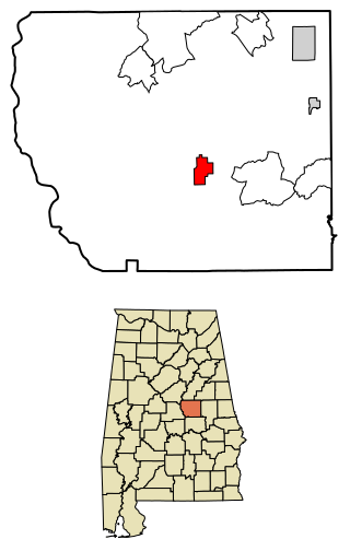
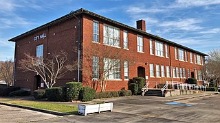
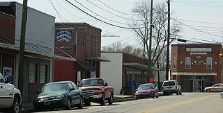
Rockford is a town in Coosa County, Alabama, United States. At the 2020 census, the population was 349. The town is the county seat of Coosa County and is part of the Talladega-Sylacauga Micropolitan Statistical Area.

<span class="mw-page-title-main">Tallassee, Alabama</span> City in Alabama, United States

Tallassee is a city on the Tallapoosa River, located in both Elmore and Tallapoosa counties in the U.S. state of Alabama. At the 2020 census, the population was 4,763. It is home to a major hydroelectric power plant at Thurlow Dam operated by Alabama Power Company.

<span class="mw-page-title-main">Boaz, Alabama</span> City in Alabama, United States

Boaz is a city in Marshall and Etowah counties in the U.S. state of Alabama. The Marshall County portion of the city is part of the Albertville Micropolitan Statistical Area. As of the 2020 census, the city's population was 10,107. Boaz was known for its outlet shops.

<span class="mw-page-title-main">Fayette, Alabama</span> City in and county seat of Fayette County, Alabama

Fayette is a city and the county seat of Fayette County, Alabama, United States. The population was 4,619 at the 2010 census, down from 4,922 at the 2000 census.

<span class="mw-page-title-main">Notasulga, Alabama</span> Town in Alabama, United States

Notasulga is a town in Macon and Lee counties in the U.S. state of Alabama. As of the 2020 census, the population of the town was 914. The portion in Lee County is part of the Auburn Metropolitan Area. According to the 1910 U.S. Census, it incorporated in 1893. Author Zora Neale Hurston was born in Notasulga in 1891. The town name comes from the Creek words noti sulgi, which means "many teeth".

<span class="mw-page-title-main">Wadley, Alabama</span> Town in Alabama, United States

Wadley is a town in Randolph County, Alabama, United States. It is home to the Wadley campus of Southern Union State Community College. As of the 2010 census, the population of the town was 751, up from 640 in 2000. According to the 1910 U.S. Census, the town was incorporated in 1908.

<span class="mw-page-title-main">Alexander City, Alabama</span> City in Alabama, United States

Alexander City, known to locals as "Alex City", is the largest city in Tallapoosa County, Alabama, United States, with a population of 14,843 as of the 2020 census. It has been the largest community in Tallapoosa County since 1910. It is known for Lake Martin with its 750 miles (1,210 km) of wooded shoreline and 44,000 acres (18,000 ha) of water. Lake Martin stands on the Tallapoosa River and offers boating, swimming, fishing, golfing, and camping. Many neighborhoods and luxury homes are located on the lake.

<span class="mw-page-title-main">Camp Hill, Alabama</span> Town in Alabama, United States

Camp Hill is a town in Tallapoosa County, Alabama, United States. It was incorporated in 1895. At the 2010 census the population was 1,014, down from 1,273 in 2000. Camp Hill is the home to Southern Preparatory Academy.

<span class="mw-page-title-main">Tallapoosa, Georgia</span> City in Georgia, United States

Tallapoosa is a city in Haralson County, Georgia. The population was 3,170 at the 2010 census, up from 2,789 at the 2000 census.

<span class="mw-page-title-main">Dadeville, Missouri</span> Village in Missouri, United States

Dadeville is a village in Dade County, Missouri, United States. The population was 226 at the 2020 census.

<span class="mw-page-title-main">Tallapoosa, Missouri</span> City in Missouri, United States

Tallapoosa is a city in New Madrid County, Missouri, United States. The population was 78 at the 2020 census.

<span class="mw-page-title-main">Tatum, Texas</span> City in Texas

Tatum is a city in Panola and Rusk Counties in the U.S. state of Texas. Its population was 1,342 at the 2020 census.

References

  1. "2020 U.S. Gazetteer Files". United States Census Bureau. Archived from the original on October 27, 2021. Retrieved October 29, 2021.
  2. "Find a County". National Association of Counties. Archived from the original on May 31, 2011. Retrieved June 7, 2011.
  3. 1 2 3 Schafer, Elizabeth D. (2002). Lake Martin, Alabama's Crown Jewel. Arcadia Publishing. pp. 30–31. ISBN   978-0-7385-2390-3.
  4. Gannett, Henry (1905). The Origin of Certain Place Names in the United States. Govt. Print. Off. pp.  98.
  5. "The Heritage of Tallapoosa County". 2000. Archived from the original on December 31, 2008. Retrieved July 15, 2010.
  6. 1 2 "Dadeville". Archived from the original on June 21, 2010. Retrieved July 16, 2010.
  7. Yan, Holly; Wolfe, Elizabeth (April 19, 2023). "3 people face murder charges for the Sweet 16 party massacre that left 4 dead and 32 injured". CNN.
  8. "Climate Summary for Dadeville, Alabama". Archived from the original on August 20, 2014. Retrieved November 7, 2013.
  9. "U.S. Decennial Census". Census.gov. Archived from the original on July 1, 2021. Retrieved June 6, 2013.
  10. "Annual Estimates of the Resident Population: April 1, 2010 to July 1, 2013". Archived from the original on May 22, 2014. Retrieved June 3, 2014.
  11. "U.S. Census website". United States Census Bureau. Archived from the original on July 9, 2021. Retrieved January 31, 2008.
  12. "U.S. Census website". United States Census Bureau. Archived from the original on July 9, 2021. Retrieved August 12, 2015.
  13. "Explore Census Data". data.census.gov. Archived from the original on December 18, 2021. Retrieved December 18, 2021.
  14. "Dadeville High School". U.S. News & World Report. Retrieved April 17, 2023.
  15. "Texas Governor Charles Allen Culberson". National Governors Association. Archived from the original on June 8, 2013.