Ozark, Alabama

Last updated

Ozark
Flag of Ozark, Alabama.png
Seal of Ozark, Alabama.png
Dale County Alabama Incorporated and Unincorporated areas Ozark Highlighted 0157648.svg
Location of Ozark in Dale County, Alabama.
Coordinates: 31°26′53″N85°38′31″W / 31.44806°N 85.64194°W / 31.44806; -85.64194
Country United States
State Alabama
County Dale
Settled1822
IncorporatedOctober 27, 1870
Government
  TypeMayor/City Council
  MayorMark Blankenship
Area
[1]
  Total34.34 sq mi (88.94 km2)
  Land34.10 sq mi (88.33 km2)
  Water0.23 sq mi (0.61 km2)
Elevation
417 ft (127 m)
Population
 (2020)
  Total14,368
  Density421.30/sq mi (162.66/km2)
Time zone UTC-6 (Central (CST))
  Summer (DST) UTC-5 (CDT)
ZIP Codes
36360-36361
Area code 334
FIPS code 01-57648
GNIS feature ID0152832
Website www.ozarkalabama.us

Ozark is a city in and the county seat of Dale County, Alabama. As of the 2010 census, the population of the city was 14,907. [2]

Contents

Ozark is the principal city of the Ozark Micropolitan Statistical Area, as well as a part of the Dothan-Ozark Combined Statistical Area. Ozark was originally a part of Enterprise–Ozark micropolitan area before being split, [3] and for a longer while was part of the Dothan-Enterprise-Ozark combined statistical area but Enterprise later became its own separate primary statistical area in later censuses. [4] [5] Fort Novosel, the primary flight training base for Army Aviation, abuts Ozark.

History

The Ozark area was originally inhabited by the Muscogee people. It is said that Ozark received its name after a traveler visited and was reminded of the Ozark Mountains in Arkansas.

The first known European settler in Ozark was John Merrick Sr., a veteran of the Revolutionary War, in 1822. In honor of him, the town was named Merricks. It was later changed to Woodshop, which was its name when the town received its post office. The first appearance of the name Ozark was in 1855, when the citizens requested a name change. [6]

The county seat was moved from Newton to Ozark 1870. [6] [7]

Ozark is home to four sites listed on the National Register of Historic Places: the Claybank Log Church, the Samuel Lawson Dowling House, the Old Train Depot, and the J. D. Holman House.

Geography

Ozark is located at 31°26′53″N85°38′31″W / 31.44806°N 85.64194°W / 31.44806; -85.64194 (31.448169, -85.642009). [8] It is part of the Wiregrass Region.

Major highways that run through the city include U.S. Route 231 and Alabama State Routes 27 and 249. US 231 runs northwest to southeast through the city, leading northwest 34 mi (55 km) to Troy and southeast 23 mi (37 km) to Dothan. SR 27 leads east 31 mi (50 km) to Abbeville and southwest 19 mi (31 km) to Enterprise.

According to the U.S. Census Bureau, the city has a total area of 34.5 square miles (89 km2) of which 34.2 square miles (89 km2) is land and 0.2 square miles (0.52 km2) (0.70%) is water.

Climate

According to the Köppen climate classification, Ozark has a humid subtropical climate (abbreviated Cfa).

Climate data for Ozark, 1991–2020 simulated normals (400 ft elevation)
MonthJanFebMarAprMayJunJulAugSepOctNovDecYear
Mean daily maximum °F (°C)59.7
(15.4)
63.7
(17.6)
70.9
(21.6)
77.4
(25.2)
84.7
(29.3)
89.2
(31.8)
90.9
(32.7)
90.3
(32.4)
86.9
(30.5)
79.0
(26.1)
69.3
(20.7)
62.1
(16.7)
77.0
(25.0)
Daily mean °F (°C)48.9
(9.4)
52.5
(11.4)
58.8
(14.9)
65.5
(18.6)
73.4
(23.0)
79.3
(26.3)
81.1
(27.3)
80.6
(27.0)
76.8
(24.9)
67.6
(19.8)
57.4
(14.1)
51.3
(10.7)
66.1
(19.0)
Mean daily minimum °F (°C)37.9
(3.3)
41.2
(5.1)
46.9
(8.3)
53.6
(12.0)
62.2
(16.8)
69.3
(20.7)
71.4
(21.9)
70.9
(21.6)
66.6
(19.2)
56.3
(13.5)
45.5
(7.5)
40.6
(4.8)
55.2
(12.9)
Average precipitation inches (mm)5.05
(128.21)
4.94
(125.41)
5.19
(131.72)
4.83
(122.73)
3.40
(86.33)
5.21
(132.32)
6.23
(158.32)
5.22
(132.60)
4.32
(109.73)
3.12
(79.17)
4.05
(102.82)
5.29
(134.27)
56.85
(1,443.63)
Average dew point °F (°C)40.3
(4.6)
43.2
(6.2)
47.3
(8.5)
54.0
(12.2)
61.5
(16.4)
68.9
(20.5)
71.6
(22.0)
71.2
(21.8)
67.3
(19.6)
57.6
(14.2)
48.2
(9.0)
43.5
(6.4)
56.2
(13.5)
Source: PRISM Climate Group [9]

Demographics

Historical population
CensusPop.Note
1880 512
1890 1,195133.4%
1900 1,57031.4%
1910 2,22942.0%
1920 2,51813.0%
1930 3,10323.2%
1940 3,60116.0%
1950 5,23845.5%
1960 9,53482.0%
1970 13,55542.2%
1980 13,188−2.7%
1990 12,922−2.0%
2000 15,11917.0%
2010 14,907−1.4%
2020 14,368−3.6%
U.S. Decennial Census [10]

2010 census

At the 2010 census, there were 14,907 people, 6,209 households, and 4,064 families living in the city. The population density was 440 inhabitants per square mile (170/km2). There were 6,920 housing units at an average density of 201.1 per square mile (77.6/km2). The racial makeup of the city was 64.8% White, 30.2% Black or African American, 0.7% Native American, 0.9% Asian, 0.0% Pacific Islander, 0.8% from other races, and 2.6% from two or more races. 3.2% of the population were Hispanic or Latino of any race.

Of the 6,209 households 26.1% had children under the age of 18 living with them, 43.3% were married couples living together, 17.5% had a female householder with no husband present, and 34.5% were non-families. 30.5% of households were one person and 12.0% were one person aged 65 or older. The average household size was 2.35 and the average family size was 2.91.

The age distribution was 23.1% under the age of 18, 8.4% from 18 to 24, 23.1% from 25 to 44, 28.2% from 45 to 64, and 17.2% 65 or older. The median age was 41.2 years. For every 100 females, there were 90.7 males. For every 100 females age 18 and over, there were 92.6 males.

The median household income was $41,079 and the median family income was $52,061. Males had a median income of $41,513 versus $28,227 for females. The per capita income for the city was $22,103. About 13.6% of families and 18.4% of the population were below the poverty line, including 27.2% of those under age 18 and 14.4% of those age 65 or over.

2020 census

Ozark racial composition [11]
RaceNum.Perc.
White (non-Hispanic)8,14756.7%
Black or African American (non-Hispanic)4,76033.13%
Native American 650.45%
Asian 1511.05%
Pacific Islander 80.06%
Other/Mixed 6714.67%
Hispanic or Latino 5663.94%

As of the 2020 United States census, there were 14,368 people, 5,946 households, and 3,651 families residing in the city.

Education

Ozark is served by the Ozark City Schools. Schools located in the city are Carroll High School (grades 9 through 12), Carroll Career Center (grades 9 through 12), D.A. Smith Middle School (grades 6 through 8), Harry N. Mixon Intermediate School (grades 3 through 5), and Joseph W. Lisenby Primary School (grades k through 2.)

Dale County School District is headquartered in Ozark, [12] but does not include Ozark. [13]

There is one private school in Ozark, Harvest Christian School for K-12.

Post-secondary education is available at Enterprise State Community College's Alabama Aviation Center at Ozark. Programs are offered in aviation maintenance technology.

Media

Radio stations

Newspaper

Notable people

See also

Related Research Articles

<span class="mw-page-title-main">Coffee County, Alabama</span> County in Alabama, United States

Coffee County is a county located in the southeastern part of the U.S. state of Alabama. As of the 2020 census, the population was 53,465. Its name is in honor of General John Coffee.

<span class="mw-page-title-main">Dale County, Alabama</span> County in Alabama, United States

Dale County is a county located in the southeastern part of the U.S. state of Alabama. As of the 2020 census the population was 49,326. Its county seat and largest city is Ozark. Its name is in honor of General Samuel Dale.

<span class="mw-page-title-main">Geneva County, Alabama</span> County in Alabama, United States

Geneva County is a county located in the southeastern part of the U.S. state of Alabama. As of the 2020 census, the population was 26,659. Its county seat is Geneva. The county was named after its county seat, which in turn was named after Geneva, New York which was named after Geneva, Switzerland, by Walter H. Yonge, an early town resident and Swiss native. Geneva County is a dry county. However, beer and wine are sold in the city limits of Geneva, Samson, Slocomb, and most recently in Hartford, after residents voted to become wet in a 2022 election.

<span class="mw-page-title-main">Valley, Alabama</span> City in Alabama, United States

Valley is a city in Chambers County, Alabama, United States. Valley was incorporated in 1980 combining the four textile mill villages of Fairfax, Langdale, River View, and Shawmut. As of the 2010 census it had a population of 9,524. The city lies on the western bank of the Chattahoochee River, the state border between Alabama and Georgia. Valley is a pilot city for the Alabama Communities of Excellence program, a non-profit that partners with governments, businesses, and universities to prepare participating communities for a more vibrant future. It is included in the LaGrange, Georgia Micropolitan Statistical Area, which is included in the Greater Atlanta Combined Statistical Area.

<span class="mw-page-title-main">Enterprise, Alabama</span> City in Coffee County, Alabama, US

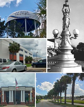
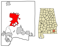
Enterprise is a city in the southeastern part of Coffee County and the southwestern part of Dale County in Southeastern Alabama, United States. Its population was 28,711 at the 2020 census. Enterprise is the primary city of the Enterprise micropolitan statistical area. It was originally a part of Enterprise–Ozark micropolitan area before being split; for a longer while it was originally part of the Dothan-Enterprise-Ozark combined statistical area but is now its own separate primary statistical area in later censuses.

<span class="mw-page-title-main">Clayhatchee, Alabama</span> Town in Alabama, United States

Clayhatchee is a town in Dale County, Alabama, United States. At the 2010 census the population was 589, up from 501 in 2000. It was incorporated in April 1967. It is part of the Ozark Micropolitan Statistical Area.

<span class="mw-page-title-main">Daleville, Alabama</span> City in Alabama, United States

Daleville is a city in Dale County, Alabama, United States. At the 2010 census the population was 5,295, up from 4,653 in 2000. It is part of the Ozark Micropolitan Statistical Area. The city's nickname is "Gateway to Fort Rucker", as this U.S. Army post is located just north of town. Cairns Army Airfield is located to the south of Daleville on the road to nearby Clayhatchee.

<span class="mw-page-title-main">Dothan, Alabama</span> City in and county seat of Houston County, Alabama

Dothan( DOH-thən) is a city in and the county seat of Houston County in the U.S. state of Alabama. A slight portion of the city extends into Dale and Henry counties. It had a population of 71,072 at the 2020 census, making it Alabama's eighth-largest city by population and the 5th largest in Alabama by total area. It is near the state's southeastern corner, about 20 miles (32 km) west of Georgia and 16 miles (26 km) north of Florida. It is named after the biblical city where Joseph's brothers threw him into a cistern and sold him into slavery in Egypt.

<span class="mw-page-title-main">Grimes, Alabama</span> Town in Alabama, United States

Grimes is a town in Dale County, Alabama, United States. At the 2010 census the population was 558, up from 459 in 2000. It is part of the Enterprise–Ozark Micropolitan Statistical Area.

<span class="mw-page-title-main">Level Plains, Alabama</span> City in Alabama, United States

Level Plains is a small town in Dale County, Alabama, United States. At the 2020 census, the population was 1,825. It is part of the Ozark micropolitan statistical area. Level Plains was ranked as a city from 2010 to 2020, but due to a population decline reverted to a town after the 2020 Census.

<span class="mw-page-title-main">Midland City, Alabama</span> Town in Alabama, United States

Midland City is a town in Dale County, Alabama, United States. At the 2010 U.S. Census the population was 2,344. It incorporated in 1890. It is part of the Ozark Micropolitan Statistical Area.

<span class="mw-page-title-main">Napier Field, Alabama</span> Town in Alabama, United States

Napier Field is a town in Dale County, Alabama. At the 2020 census, the population was 409. It is part of the Ozark micropolitan statistical area. The town was originally constructed as a military air base during the Second World War. It is currently adjacent to Dothan Regional Airport. While the airport itself lies within Dothan's city limits, the adjacent housing units and other buildings constitute the incorporated town of Napier Field.

<span class="mw-page-title-main">Newton, Alabama</span> Town in Alabama, United States

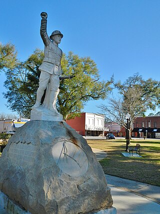
Newton is a town in Dale County, Alabama, United States. At the 2010 census its population was 1,511. Once the county seat of Dale County, Newton lost this distinction to nearby Ozark in 1870, and is now a small farming community. It incorporated in 1887. The city currently forms a part of the Ozark micropolitan statistical area.

<span class="mw-page-title-main">Pinckard, Alabama</span> Town in Alabama, United States

Pinckard is a town in Dale County, Alabama, United States. At the 2020 census, the population was 582. Pinckard incorporated in 1893 and is part of the Ozark Micropolitan Statistical Area.

<span class="mw-page-title-main">Slocomb, Alabama</span> City in Alabama, United States

Slocomb is a city in Geneva County, Alabama, United States. It is part of the Dothan, Alabama Metropolitan Statistical Area. At the 2020 census, the population was 2,082. The community is named after postmaster Frank W. Slocomb.

<span class="mw-page-title-main">Abbeville, Alabama</span> City in and county seat of Henry County, Alabama

Abbeville is a city in and the county seat of Henry County, in the southeast part of Alabama, United States. It is part of the Dothan, Alabama Metropolitan Statistical Area. At the 2020 census, the population was 2,358.

<span class="mw-page-title-main">Headland, Alabama</span> City in Alabama, United States

Headland is the largest city in Henry County, Alabama, United States. It is part of the Dothan metropolitan area. In 2020, the population was 4,973, up from 4,510 in the 2010 census. Ray Marler is the current mayor.

<span class="mw-page-title-main">Dothan metropolitan area, Alabama</span> Metropolitan Statistical Area in Alabama, United States

The Dothan Metropolitan Statistical Area, as defined by the United States Census Bureau, is an area consisting of Geneva, Henry, and Houston counties in southeastern Alabama, anchored by the city of Dothan, county seat of Houston County. As of the 2010 census, the MSA had a population of 145,639.

<span class="mw-page-title-main">Dothan–Enterprise–Ozark Combined Statistical Area</span> Combined Statistical Area in Alabama, United States

The Dothan–Enterprise–Ozark Combined Statistical Area was a CSA made up of five counties in the southeastern corner of the U.S. state of Alabama. The once statistical area includes one metropolitan area and originally one micropolitan area which then was split off as two. As of the 2010 census, the CSA had a population of 245,838. Currently an updated area called the Dothan-Ozark Combined Statistical area is used instead and Enterprise micropolitan area is now split as its own statistical area.

<span class="mw-page-title-main">Enterprise–Ozark micropolitan area</span> Micropolitan Statistical Area in Alabama, United States

The Enterprise–Ozark Micropolitan Statistical Area, as defined by the United States Census Bureau, was an area consisting of two counties in southeastern Alabama, anchored by the cities of Enterprise and Ozark. As of the 2000 census, the μSA had a population of 92,744.

References

  1. "2020 U.S. Gazetteer Files". United States Census Bureau. Retrieved October 29, 2021.
  2. "Geographic Identifiers: 2010 Demographic Profile Data (G001): Ozark city, Alabama". U.S. Census Bureau, American Factfinder. Retrieved October 2, 2015.[ dead link ]
  3. "Table 1. Annual Estimates of the Population of Metropolitan and Micropolitan Statistical Areas: April 1, 2000 to July 1, 2009 (CBSA-EST2009-01)". 2009 Population Estimates. United States Census Bureau, Population Division. March 23, 2010. Archived from the original (CSV) on March 26, 2010. Retrieved March 24, 2010.
  4. "Dothan-Enterprise-Ozark, AL Combined Statistical Area" (PDF) (Map). www.2census.gov. US Census Bureau . Retrieved December 14, 2021.
  5. "OMB Bulletin No. 20-01: Revised Delineations of Metropolitan Statistical Areas, Micropolitan Statistical Areas, and Combined Statistical Areas, and Guidance on Uses of the Delineations of These Areas" (PDF). United States Office of Management and Budget. March 6, 2020. Retrieved September 21, 2020.
  6. 1 2 Watson, Fred Shelton (1968). Forgotten trails: a history of Dale County, Alabama, 1824–1966. Birmingham, Alabama: Banner Press. p. 288.
  7. Hoskins Morton, Patricia (December 10, 2010). "Dale County". Encyclopedia of Alabama. Retrieved February 1, 2010.
  8. "US Gazetteer files: 2010, 2000, and 1990". United States Census Bureau. February 12, 2011. Retrieved April 23, 2011.
  9. "PRISM Climate Group at Oregon State University". Northwest Alliance for Computational Science & Engineering (NACSE), based at Oregon State University. Retrieved March 15, 2023.
  10. United States Census Bureau. "Census of Population and Housing" . Retrieved June 7, 2014.
  11. "Explore Census Data". data.census.gov. Retrieved December 17, 2021.
  12. "Home". Dale County School District. Retrieved July 4, 2022. 202 South Highway 123, Ozark, AL 36360
  13. "2020 CENSUS - SCHOOL DISTRICT REFERENCE MAP: Dale County, AL" (PDF). U.S. Census Bureau . Retrieved July 4, 2022. - Text list - "Fort Rucker School District" refers to DoDEA schools.

31°26′53″N85°38′31″W / 31.448169°N 85.642009°W / 31.448169; -85.642009