Columbiana, Alabama

Last updated

Columbiana, Alabama
Columbiana, Alabama.JPG
Columbiana, Alabama
Motto(s): 
"Embracing The Future, While Preserving The Past”
Shelby County Alabama Incorporated and Unincorporated areas Columbiana Highlighted 0116768.svg
Location of Columbiana in Shelby County, Alabama.
Coordinates: 33°11′35″N86°36′41″W / 33.19306°N 86.61139°W / 33.19306; -86.61139
Country United States
State Alabama
County Shelby
Government
  MayorDavid Mitchell
Area
[1]
  Total17.40 sq mi (45.07 km2)
  Land17.30 sq mi (44.81 km2)
  Water0.10 sq mi (0.26 km2)
Elevation
[2]
574 ft (175 m)
Population
 (2020)
  Total4,462
  Density257.89/sq mi (99.57/km2)
Time zone UTC-6 (Central (CST))
  Summer (DST) UTC-5 (CDT)
ZIP code
35051
Area code(s) 205, 659
FIPS code 01-16768
GNIS feature ID2404109 [2]
Website cityofcolumbiana.com

Columbiana is a city and the county seat of Shelby County, Alabama, United States. [3] At the 2020 census, the population was 4,462.

Contents

History

Columbiana, originally called Columbia, was selected as the county seat of Shelby County in 1826 over rivals Calera and Montevallo. After the selection as the county seat, Columbiana celebrated by drilling holes in a large pine tree and packing it with gunpowder. The tree was blown up and the sound could be heard for miles. Later in 1826, the courthouse was moved to an old school building in Columbiana.

An act of the Alabama Legislature officially changed the name of Shelby County's county seat to Columbiana on January 13, 1832. Columbiana was incorporated on December 5, 1837, with corporate limits one-quarter of a mile in each direction from the public square.

In 1854, the decision was made to build a larger courthouse at the south end of “Silk Stocking Road”, now Main Street. From 1854 to 1908 several additions and changes were made to the courthouse. During the American Civil War, Columbiana was connected to the nearby town of Shelby by the Shelby Iron Company Railroad, which connected the Shelby Iron Works to the Alabama and Tennessee River Railroad. The Iron Works supplied iron to the C.B. Churchill and Company foundry, which moved to Columbiana in 1862 after the fall of Corinth, Mississippi. The Churchill foundry made eight and ten pound shot, eight and ten pound shells, and shells for Blakely rifles. [4] The C.B. Churchill and Company foundry, Shelby Iron Works and the railroad were destroyed by Union forces on March 31, 1865, as part of Wilson's Raid.

Moving the courthouse to Columbiana was not necessarily popular in 1826 and there have been numerous attempts to relocate the county seat over the years. In 1901, the Alabama Constitutional Convention addressed the issue by including Section 41 in the new state constitution. Section 41 prohibited a move of the Shelby County seat from Columbiana unless a vote of the people was held, the only county in Alabama with such a designation.

To further solidify Columbiana's claim to the county seat, in 1905 construction began two blocks north of the existing courthouse on a new marble courthouse at a cost of $300,000. The new courthouse was completed in 1908 and has been renovated and enlarged on a number of occasions. The new courthouse has served Shelby County for over 100 years.

The “Old Courthouse” is now home to the Shelby County Museum and Archives.

Today, Columbiana is home to the Shelby County Board of Education, the Shelby County Sheriff's Office, the Shelby County Jail, and Harrison Regional Library, which is the main office for the Shelby County Library System. Columbiana holds the annual Liberty Day celebration on the last weekend in June, which was first held in 1986 to honor the 100th anniversary of the Statue of Liberty. The current mayor is David Mitchell. [5]

The population of Columbiana was 4,546 as of 2021. [6]

Geography

The city is located in the southeastern part of the county along Alabama State Route 25, which runs northeast to southwest to the west of the downtown area, leading northeast 9 miles (14 km) to Wilsonville and southwest 11 miles (18 km) to Calera.

City government

Columbiana is a municipal corporation organized under the laws of the State of Alabama. The city is 25 miles (40 km) southeast of Birmingham. According to the 2010 census conducted by the U.S. Department of Commerce, the population of Columbiana was 4,197. There are 16.86 square miles (43.7 km2) within the corporate limits of Columbiana.

Columbiana is governed under the mayor-council form of government. The mayor is elected on an at-large basis for a four-year term and the five council members are elected from single member districts, each for a four-year term. The mayor and council serve on a part-time basis. The mayor serves as chief executive officer of the city and is responsible for the daily operations of all departments of the city. The council acts as the legislative branch of the city.

Municipal operations are financed largely by sales tax, utility revenues, privilege licenses, and property taxes.

Elected officials

Demographics

Historical population
CensusPop.Note
1880 496
1890 65431.9%
1900 1,07564.4%
1910 1,0790.4%
1920 1,073−0.6%
1930 1,18010.0%
1940 1,1971.4%
1950 1,76147.1%
1960 2,26428.6%
1970 2,248−0.7%
1980 2,65518.1%
1990 2,96811.8%
2000 3,31611.7%
2010 4,19726.6%
2020 4,4626.3%
U.S. Decennial Census [7]

2000 census

At the 2000 census there were 3,316 people in 1,260 households, including 868 families, in the city. The population density was 218.5 inhabitants per square mile (84.4/km2). There were 1,372 housing units at an average density of 90.4 per square mile (34.9/km2). The racial makeup of the city was 78.59% White, 19.60% Black or African American, 0.24% Native American, 0.15% Asian, 0.03% Pacific Islander, 0.66% from other races, and 0.72% from two or more races. 1.99% of the population were Hispanic or Latino of any race. [8] Of the 1,260 households 34.0% had children under the age of 18 living with them, 51.8% were married couples living together, 13.4% had a female householder with no husband present, and 31.1% were non-families. 29.2% of households were one person and 12.9% were one person aged 65 or older. The average household size was 2.50 and the average family size was 3.10.

The age distribution was 25.9% under the age of 18, 8.3% from 18 to 24, 31.6% from 25 to 44, 21.8% from 45 to 64, and 12.4% 65 or older. The median age was 36 years. For every 100 females, there were 100.5 males. For every 100 females age 18 and over, there were 93.2 males.

The median household income was $34,034 and the median family income was $44,798. Males had a median income of $34,350 versus $21,193 for females. The per capita income for the city was $18,086. About 8.2% of families and 11.5% of the population were below the poverty line, including 15.3% of those under age 18 and 14.2% of those age 65 or over.

2010 census

At the 2010 census there were 4,197 people in 1,303 households, including 874 families, in the city. The population density was 218.2 inhabitants per square mile (84.2/km2). There were 1,445 housing units at an average density of 95.1 per square mile (36.7/km2). The racial makeup of the city was 71.3% White, 25.1% Black or African American, 0.3% Native American, 0.2% Asian, 0.1% Pacific Islander, 1.6% from other races, and 1.3% from two or more races. 3.0% of the population were Hispanic or Latino of any race. [9] Of the 1,303 households 28.4% had children under the age of 18 living with them, 47.5% were married couples living together, 14.7% had a female householder with no husband present, and 32.9% were non-families. 29.7% of households were one person and 15.6% were one person aged 65 or older. The average household size was 2.52 and the average family size was 3.12.

The age distribution was 19.7% under the age of 18, 9.7% from 18 to 24, 32.2% from 25 to 44, 24.3% from 45 to 64, and 14.1% 65 or older. The median age was 37.8 years. For every 100 females, there were 121.1 males. For every 100 females age 18 and over, there were 148.9 males.

The median household income was $31,108 and the median family income was $56,411. Males had a median income of $43,304 versus $34,583 for females. The per capita income for the city was $21,003. About 11.0% of families and 16.2% of the population were below the poverty line, including 29.1% of those under age 18 and 9.2% of those age 65 or over.

2020 census

Columbiana racial composition [10]
RaceNum.Perc.
White (non-Hispanic)3,13970.35%
Black or African American (non-Hispanic)1,00322.48%
Native American 30.07%
Asian 70.16%
Other/Mixed 1753.92%
Hispanic or Latino 1353.03%

As of the 2020 United States census, there were 4,462 people, 1,641 households, and 851 families residing in the city.

Education

Shelby County Schools operates public schools.

Notable people

Related Research Articles

<span class="mw-page-title-main">Shelby County, Alabama</span> County in Alabama, United States

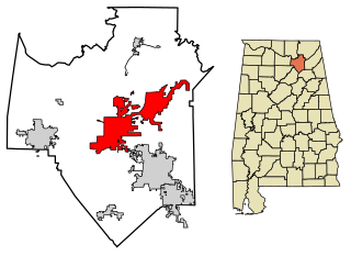
Shelby County is located in the central portion of the U.S. state of Alabama. As of the 2020 census the population was 223,024, making it the sixth-most populous county in Alabama. The county seat is Columbiana. Its largest city is Alabaster. The county is named in honor of Isaac Shelby, Governor of Kentucky from 1792 to 1796 and again from 1812 to 1816. Shelby County is included in the Birmingham–Hoover, AL Metropolitan Statistical Area.

<span class="mw-page-title-main">Shelby County, Iowa</span> County in Iowa, United States

Shelby County is a county located in the U.S. state of Iowa. As of the 2020 census, the population was 11,746. The county seat is Harlan. Its name is in honor of Isaac Shelby, the first Governor of Kentucky.

<span class="mw-page-title-main">Oneonta, Alabama</span> City in Alabama, United States

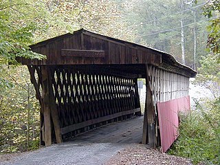
Oneonta is a city in Blount County, Alabama, United States. At the 2020 census, the population was 6,938. The city is the county seat of Blount County. Oneonta is home to the Covered Bridge Festival.

<span class="mw-page-title-main">Andalusia, Alabama</span> City in and county seat of Covington County, Alabama

Andalusia is a city in and the county seat of Covington County, Alabama, United States. At the 2020 census, the population was 8,805.

<span class="mw-page-title-main">Good Hope, Alabama</span> City in Alabama, United States

Good Hope is a city in Cullman County, Alabama, United States. As of the 2010 census, the population of the city was 2,264. It incorporated in April 1962.

<span class="mw-page-title-main">Eutaw, Alabama</span> City in and county seat of Greene County, Alabama

Eutaw is a city in and the county seat of Greene County, Alabama, United States. At the 2020 census, the population was 2,937. The city was named in honor of the Battle of Eutaw Springs, the last engagement of the American Revolutionary War in the Carolinas.

<span class="mw-page-title-main">Hamilton, Alabama</span> City in Alabama, United States

Hamilton is a city in and the county seat of Marion County, Alabama, United States. It incorporated in 1896 and since 1980 has been the county's largest city, surpassing Winfield. It was previously the largest town in 1910. At the 2020 census, the population was 7,042.

<span class="mw-page-title-main">Guntersville, Alabama</span> City in Alabama, United States

Guntersville is a city and the county seat of Marshall County, Alabama, United States. At the 2020 census, the population of the city was 8,553. Guntersville is located in a HUBZone as identified by the U.S. Small Business Administration (SBA).

<span class="mw-page-title-main">Harpersville, Alabama</span> Town in Alabama, United States

Harpersville is a town in Shelby County, Alabama, United States. According to the 1950 U.S. Census, it formally incorporated in 1943. At the 2020 census the population was 1,614, compared to 1,637 in 2010 and 1,620 in 2000. It is located southeast of the Birmingham metro area.

<span class="mw-page-title-main">Wilsonville, Alabama</span> Town in Alabama, United States

Wilsonville is a town in southeastern Shelby County, Alabama, United States, located northeast of Columbiana. At the 2020 census, the population was 1,857. Wilsonville is named after the earliest settler in the area, Elisha Wilson.

<span class="mw-page-title-main">Livingston, Alabama</span> City in Alabama, United States

Livingston is a city in and the county seat of Sumter County, Alabama, United States and the home of the University of West Alabama. By an act of the state legislature, it was incorporated on January 10, 1835. At the 2010 census the population was 3,485, up from 3,297 in 2000. It was named in honor of Edward Livingston, of the Livingston family of New York.

<span class="mw-page-title-main">Hanoverton, Ohio</span> Village in Ohio, United States

Hanoverton is a village in western Columbiana County, Ohio, United States. The population was 354 at the 2020 census. It is part of the Salem micropolitan area, 23 miles (37 km) miles east of Canton and 28 miles (45 km) southwest of Youngstown.

<span class="mw-page-title-main">Leetonia, Ohio</span> Village in Ohio, United States

Leetonia is a village in northern Columbiana County, Ohio, United States. The population was 1,833 at the 2020 census. It is part of the Salem micropolitan area, about 16 miles (26 km) south of Youngstown.

<span class="mw-page-title-main">Lisbon, Ohio</span> Village in Ohio, United States

Lisbon is a village in and the county seat of Columbiana County, Ohio, United States, along the Little Beaver Creek. The population was 2,597 at the 2020 census. It is a part of the Salem micropolitan area, about 23 miles (37 km) southwest of Youngstown.

<span class="mw-page-title-main">Salineville, Ohio</span> Village in Ohio, United States

Salineville is a village in southwestern Columbiana County, Ohio, United States. The population was 1,206 at the 2020 census. It is part of the Salem micropolitan area, about 20 miles (32 km) northwest of Steubenville and 34 miles (55 km) southwest of Youngstown.

<span class="mw-page-title-main">Summitville, Ohio</span> Village in Ohio, United States

Summitville is a village in southwestern Columbiana County, Ohio, United States. The population was 110 at the 2020 census. It is part of the Salem micropolitan area, 27 miles (43 km) miles southeast of Canton and 32 miles (51 km) southwest of Youngstown.

<span class="mw-page-title-main">Maple Heights, Ohio</span> City in Ohio, United States

Maple Heights is a city in Cuyahoga County, Ohio, United States. It is a suburb of Cleveland. The population was 23,701 at the 2020 census.

<span class="mw-page-title-main">Columbiana, Ohio</span> City in Ohio, United States

Columbiana is a city in northern Columbiana and southern Mahoning counties in the U.S. state of Ohio. The population was 6,559 at the 2020 census. It is part of the Salem micropolitan area and Youngstown–Warren metropolitan area.

<span class="mw-page-title-main">Washingtonville, Ohio</span> Village in Ohio, United States

Washingtonville is a village in northern Columbiana and southern Mahoning counties in the U.S. state of Ohio. The population was 712 at the 2020 census. Southern Washingtonville is included in the Salem micropolitan area, while northern Washingtonville is part of the Youngstown–Warren metropolitan area.

<span class="mw-page-title-main">St. Clair County, Alabama</span> County in Alabama, United States

St. Clair County is a county located in the central portion of the U.S. state of Alabama. As of the 2020 census, the population was 91,103. It has two county seats: Ashville and Pell City. It is one of two counties in Alabama, and one of 33 in the United States, with more than one county seat. Its name is in honor of General Arthur St. Clair, an officer in the French and Indian War. St. Clair County is included in the Birmingham, Alabama Metropolitan Statistical Area.

References

  1. "2020 U.S. Gazetteer Files". United States Census Bureau. Retrieved October 29, 2021.
  2. 1 2 U.S. Geological Survey Geographic Names Information System: Columbiana, Alabama
  3. "Find a County". National Association of Counties. Archived from the original on May 31, 2011. Retrieved June 7, 2011.
  4. Armes, Ethel (1910). The story of coal and iron in Alabama - Ethel Armes - Google Books . Retrieved June 17, 2014.
  5. Sparacino, Emily (October 6, 2020). "Mitchell wins Columbiana mayor runoff". Shelby County Reporter. Retrieved February 9, 2021.
  6. "Columbiana, Alabama Population 2021". World Population Review. Retrieved February 9, 2021.
  7. "U.S. Decennial Census". Census.gov. Retrieved June 6, 2013.
  8. "U.S. Census website". United States Census Bureau . Retrieved January 31, 2008.
  9. "U.S. Census website". United States Census Bureau . Retrieved August 8, 2015.
  10. "Explore Census Data". data.census.gov. Retrieved December 11, 2021.
  11. "School Classification". AHSAA. Retrieved July 8, 2013.
  12. Lewis, Herbert. "Horace Ware". Encyclopedia of Alabama. Retrieved January 22, 2021.