Ancient Oaks is a census-designated place (CDP) in Lower Macungie Township in Lehigh County, Pennsylvania, United States. It is named after the housing subdivision named Ancient Oaks, located off PA Route 100 just north of Macungie. The population of Ancient Oaks was 6,995 at the 2020 census.

Fountain Hill is a borough in Lehigh County, Pennsylvania, United States. The population of Fountain Hill was 4,832 at the 2020 census, an increase over the figure of 4,597 tabulated in 2010. It is part of the Lehigh Valley metropolitan area, which had a population of 861,899 and was the 68th-most populous metropolitan area in the U.S. as of the 2020 census.
Hokendauqua is an unincorporated community and census-designated place (CDP) in Whitehall Township in Lehigh County, Pennsylvania, United States. The population of Hokendauqua was 3,340 as of the 2020 census. Hokendauqua is a suburb of Allentown, Pennsylvania in the Lehigh Valley metropolitan area, which had a population of 861,899 and was the 68th-most populous metropolitan area in the U.S. as of the 2020 census.

Upper Saucon Township is a township in Lehigh County, Pennsylvania. It is part of the Lehigh Valley metropolitan area, which had a population of 861,899 and was the 68th-most populous metropolitan area in the U.S. as of the 2020 census. The township had a population of 16,970 as of the 2020 census.

Walnutport is a borough in Northampton County, Pennsylvania. It was first incorporated in 1909. The population of Walnutport was 2,067 at the 2020 census.
Wilson is a borough in Northampton County, Pennsylvania. The population was 8,259 at the 2020 census. Wilson is located adjacent to the city of Easton and is part of the Lehigh Valley metropolitan area, which had a population of 861,899 and was the 68th-most populous metropolitan area in the U.S. as of the 2020 census.

Wind Gap is a borough in Northampton County, Pennsylvania. The population of Wind Gap was 2,820 at the 2020 census. Wind Gap is part of the Lehigh Valley metropolitan area, which had a population of 861,899 and was the 68th-most populous metropolitan area in the U.S. as of the 2020 census.

Trexlertown is an unincorporated community and census-designated place (CDP) in Upper Macungie Township in Lehigh County, Pennsylvania. As of the 2020 census, the population was 2,382. It is part of the Lehigh Valley, which had a population of 861,899 and was the 68th-most populous metropolitan area in the U.S. as of the 2020 census, and lies between Breinigsville and Wescosville.

Dorneyville is a census-designated place in Lehigh County, Pennsylvania. As of the 2020 census the population was 4,850. Dorneyville is located just west of Allentown in South Whitehall Township and Salisbury Township.

New Tripoli is an unincorporated community and census-designated place (CDP) in Lynn Township in Lehigh County, Pennsylvania. As of the 2020 census, the population was 840. New Tripoli is part of the Lehigh Valley, which had a population of 861,899 and was the 68th-most populous metropolitan area in the U.S. as of the 2020 census.

Martins Creek is a census-designated place in Lower Mt. Bethel Township, Pennsylvania. It is located along Martins Creek. Its population was 664 as of the 2020 U.S. census. Martins Creek is part of the Lehigh Valley metropolitan area, which had a population of 861,899 and was the 68th-most populous metropolitan area in the U.S. as of the 2020 census. The Zip Code is 18063.

Center Valley is an unincorporated community located one mile north of Coopersburg, at the intersection of Pennsylvania State Routes 309 and 378 in Upper Saucon Township in Lehigh County, Pennsylvania. It is part of the Lehigh Valley, which had a population of 861,899 and was the 68th-most populous metropolitan area in the U.S. as of the 2020 census.
Cetronia is a census-designated place (CDP) in South Whitehall Township in Lehigh County, Pennsylvania, located near Allentown. As of the 2020 census, its population was 2,421.

Laurys Station is an unincorporated community and census-designated place (CDP) in North Whitehall Township in Lehigh County, Pennsylvania. It is part of the Lehigh Valley, which had a population of 861,899 and was the 68th-most populous metropolitan area in the U.S. as of the 2020 census. It is located approximately 9 miles (14 km) north of Allentown and about 6 miles (10 km) southeast of Walnutport.

Cementon is an unincorporated area and census-designated place (CDP) in Lehigh County, Pennsylvania. The town is in Whitehall Township, 7 miles (11 km) north of Allentown. As of the 2020 census, the population of Cementon was 1,657. Cementon is part of the Lehigh Valley metropolitan area, which had a population of 861,899 and was the 68th-most populous metropolitan area in the U.S. as of 2020. It uses the Whitehall Township ZIP Code of 18052.

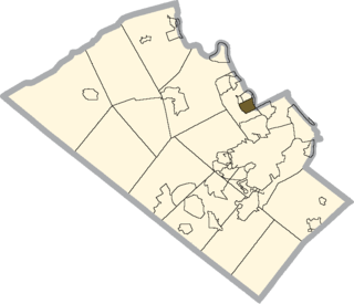
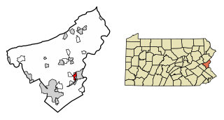
Cherryville is a census-designated place in Lehigh Township in Northampton County, Pennsylvania. Its population was 1,618 as of the 2020 U.S. census.

Raubsville is a census-designated place in Williams Township, Pennsylvania. The population of Raubsville was 1,079 residents as of the 2020 census. Raubsville is located along PA Route 611 on the west bank of the Delaware River. It is part of the Lehigh Valley metropolitan area, which had a population of 861,899 and was the 68th-most populous metropolitan area in the U.S. as of the 2020 census.

Ackermanville is a census-designated place located on PA Route 191 in Washington Township, Pennsylvania. As of the 2020 census, the village's population was 572. Ackermanville is part of the Lehigh Valley metropolitan area, which had a population of 861,899 and was the 68th-most populous metropolitan area in the U.S. as of the 2020 census. It was named for the Ackerman family.
Chestnut Hill is an unincorporated community and census-designated place (CDP) in Northampton County, Pennsylvania. It was first listed as a CDP prior to the 2020 census. Its population as of the 2020 census was 6,689. It is part of the Lehigh Valley metropolitan area, which had a population of 861,899 and was the 68th-most populous metropolitan area in the U.S. as of 2020.
Morgan Hill is a suburban unincorporated community and census-designated place (CDP) in Northampton County, Pennsylvania. It was first listed as a CDP prior to the 2020 census. As of the 2020 census, its population was 1,034. Morgan Hill is part of the Lehigh Valley metropolitan area, which had a population of 861,899 and was the 68th-most populous metropolitan area in the U.S. as of the 2020 census.


