Ancient Oaks is a census-designated place (CDP) in Lower Macungie Township in Lehigh County, Pennsylvania, United States. It is named after the housing subdivision named Ancient Oaks, located off PA Route 100 just north of Macungie. The population of Ancient Oaks was 6,995 at the 2020 census.
Hokendauqua is an unincorporated community and census-designated place (CDP) in Whitehall Township in Lehigh County, Pennsylvania, United States. The population of Hokendauqua was 3,340 as of the 2020 census. Hokendauqua is a suburb of Allentown, Pennsylvania in the Lehigh Valley metropolitan area, which had a population of 861,899 and was the 68th-most populous metropolitan area in the U.S. as of the 2020 census.

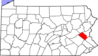
Schnecksville is an unincorporated community and census-designated place (CDP) in North Whitehall Township in Lehigh County, Pennsylvania. The population of Schnecksville was 2,935 at the 2010 census.
Slatington is a borough in Lehigh County, Pennsylvania. As of the 2010 census, it had a population of 4,232. Slatington is located northwest of Allentown and Bethlehem. Slatington is part of the Lehigh Valley metropolitan area, which had a population of 861,899 and was the 68th-most populous metropolitan area in the U.S. as of the 2020 census.
Washington Township is a township in Lehigh County, Pennsylvania. The population of Washington Township was 6,624 at the 2010 census. It is a suburb of Allentown in the Lehigh Valley, which had a population of 861,899 and was the 68th-most populous metropolitan area in the U.S. as of the 2020 census.

Lehigh Township is a township in Northampton County, Pennsylvania. The population of Lehigh Township was 10,526 as of the 2010 census. It is part of the Lehigh Valley metropolitan area, which had a population of 861,899 and was the 68th-most populous metropolitan area in the U.S. as of the 2020 census.

Walnutport is a borough in Northampton County, Pennsylvania. It was first incorporated in 1909. The population of Walnutport was 2,067 at the 2020 census.

Trexlertown is an unincorporated community and census-designated place (CDP) in Upper Macungie Township in Lehigh County, Pennsylvania. As of the 2020 census, the population was 2,382. It is part of the Lehigh Valley, which had a population of 861,899 and was the 68th-most populous metropolitan area in the U.S. as of the 2020 census, and lies between Breinigsville and Wescosville.

Dorneyville is a census-designated place in Lehigh County, Pennsylvania. As of the 2020 census the population was 4,850. Dorneyville is located just west of Allentown in South Whitehall Township and Salisbury Township.

New Tripoli is an unincorporated community and census-designated place (CDP) in Lynn Township in Lehigh County, Pennsylvania. As of the 2020 census, the population was 840. New Tripoli is part of the Lehigh Valley, which had a population of 861,899 and was the 68th-most populous metropolitan area in the U.S. as of the 2020 census.
Hopeland is a small unincorporated hamlet and census-designated place (CDP) that is located in Lancaster County in the south of the U.S. state of Pennsylvania in the United States. The hamlet's ZIP code is 17533.
Stevens is an unincorporated community and census-designated place (CDP) in Lancaster County, Pennsylvania, United States. As of the 2010 census, it had a population of 612. The Stevens post office has ZIP code 17578.

Georgetown is an unincorporated community and census-designated place (CDP) in Bart Township, Lancaster County, Pennsylvania, United States. As of the 2010 census, the population was 1,022. Georgetown has a post office for P.O. boxes that is called Bart and has the ZIP code of 17503. Otherwise, the CDP is divided into three ZIP code areas for more distant communities.

Wescosville is a census-designated place located in Lehigh County, Pennsylvania. It is located between Allentown and Trexlertown in Lower Macungie Township. It is part of the Lehigh Valley, which had a population of 861,899 and was the 68th-most populous metropolitan area in the U.S. as of the 2020 census.
Cetronia is a census-designated place (CDP) in South Whitehall Township in Lehigh County, Pennsylvania, located near Allentown. As of the 2020 census, its population was 2,421.
Wakefield is an unincorporated community and census-designated place (CDP) within Fulton Township, Lancaster County, Pennsylvania, United States. As of the 2010 census, the population was 609. It is the largest community within the "Peach Bottom" ZIP code, with the area post office on Pennsylvania Route 272, just north of town.

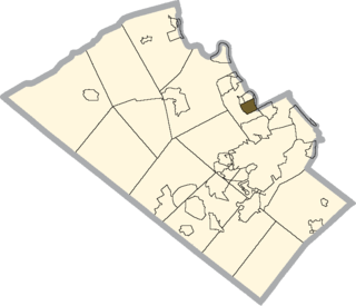
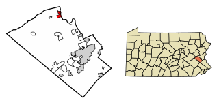
Laurys Station is an unincorporated community and census-designated place (CDP) in North Whitehall Township in Lehigh County, Pennsylvania. It is part of the Lehigh Valley, which had a population of 861,899 and was the 68th-most populous metropolitan area in the U.S. as of the 2020 census. It is located approximately 9 miles (14 km) north of Allentown and about 6 miles (10 km) southeast of Walnutport.

Cementon is an unincorporated area and census-designated place (CDP) in Lehigh County, Pennsylvania. The town is in Whitehall Township, 7 miles (11 km) north of Allentown. As of the 2020 census, the population of Cementon was 1,657. Cementon is part of the Lehigh Valley metropolitan area, which had a population of 861,899 and was the 68th-most populous metropolitan area in the U.S. as of 2020. It uses the Whitehall Township ZIP Code of 18052.

Stiles is an unincorporated community and census-designated place (CDP) that is located in Whitehall Township in Lehigh County, Pennsylvania. As of the 2010 census, the population was 1,113.
Emerald is an unincorporated exurban community in Washington Township in Lehigh County, Pennsylvania. It is located two miles west of Slatington.


