
Kidder Township is a township in Carbon County, Pennsylvania. It is part of Northeastern Pennsylvania. The population was 1,935 at the 2010 census, up from 1,185 at the 2000 census.

Lausanne Township is a township in Carbon County, Pennsylvania. It is part of Northeastern Pennsylvania. The township dates back to 1808 when the first Lausanne settlement was organized with a local frontier government.

Emmaus is a borough in Lehigh County, Pennsylvania. As of the 2020 U.S. census, it had a population of 11,652. Emmaus is located in the Lehigh Valley, the third-largest metropolitan area in Pennsylvania and 68th-largest metropolitan area in the nation.

Hanover Township is a township in Lehigh County, Pennsylvania. As of the 2010 census, the township had a population of 1,571. It is a suburb of Allentown and Bethlehem and part of the Lehigh Valley metropolitan area, which had a population of 861,899 and was the 68th-most populous metropolitan area in the U.S. as of the 2020 census.

Heidelberg Township is a township in Lehigh County, Pennsylvania. The population of Heidelberg Township was 3,416 at the 2010 census. It is a suburb of Allentown in the Lehigh Valley, which had a population of 861,899 and was the 68th-most populous metropolitan area in the U.S. as of the 2020 census.

Lower Macungie Township is a township in Lehigh County, Pennsylvania. The township's population was 31,964 as of the 2020 census, making it the second-largest population center in Lehigh County after Allentown and the third-largest population center in the Lehigh Valley metropolitan area after Allentown and Bethlehem.

Lowhill Township is a township in Lehigh County, Pennsylvania. The population of Lowhill Township was 2,173 at the 2010 census. It is a suburb of Allentown, in the Lehigh Valley, which had a population of 861,899 and was the 68th-most populous metropolitan area in the U.S. as of the 2020 census.

North Whitehall Township is a township in Lehigh County, Pennsylvania. The population of North Whitehall Township was 15,655 at the 2020 census. It is a suburb of Allentown in the Lehigh Valley, which had a population of 861,899 and was the 68th-most populous metropolitan area in the U.S. as of the 2020 census.

Salisbury Township is a township in Lehigh County, Pennsylvania. The township's population was 13,505 at the 2010 census. The township borders Allentown, Pennsylvania's third-largest city, Bethlehem, and Emmaus, in the Lehigh Valley, which had a population of 861,899 and was the 68th-most populous metropolitan area in the U.S. as of the 2020 census.

South Whitehall Township is a township in Lehigh County, Pennsylvania. The township's population was 19,180 at the 2010 census. It is a suburb of Allentown and is part of the Lehigh Valley, which had a population of 861,899 and was the 68th-most populous metropolitan area in the U.S. as of the 2020 census.

Upper Macungie Township is a township in Lehigh County, Pennsylvania. The population of Upper Macungie Township was 26,377 as of the 2020 U.S. census, making it the fourth-fastest growing municipality of any category in Pennsylvania in terms of total population growth between 2010 and 2020.

Upper Milford Township is a township in Lehigh County, Pennsylvania. The township's population was 7,292 at the 2010 census. Upper Milford Township is a suburb of Allentown in the Lehigh Valley, which had a population of 861,899 and was the 68th-most populous metropolitan area in the U.S. as of the 2020 census.
Washington Township is a township in Lehigh County, Pennsylvania. The population of Washington Township was 6,624 at the 2010 census. It is a suburb of Allentown in the Lehigh Valley, which had a population of 861,899 and was the 68th-most populous metropolitan area in the U.S. as of the 2020 census.

Whitehall Township is a township with home rule status in Lehigh County, Pennsylvania. The township's population was 26,738 as of the 2010 census.
Allen Township is a township in Northampton County, Pennsylvania. The population of Allen Township was 4,269 at the 2010 census. Allen Township is part of the Lehigh Valley metropolitan area, which had a population of 861,899 and was the 68th-most populous metropolitan area in the U.S. as of the 2020 census.

Lehigh Township is a township in Northampton County, Pennsylvania. The population of Lehigh Township was 10,526 as of the 2010 census. It is part of the Lehigh Valley metropolitan area, which had a population of 861,899 and was the 68th-most populous metropolitan area in the U.S. as of the 2020 census.
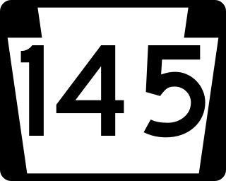
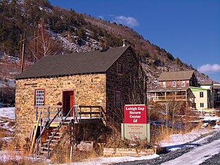
Pennsylvania Route 145 is a 20.89 mi (33.62 km) long north–south state highway in the Lehigh Valley area of eastern Pennsylvania. It connects Interstate 78 (I-78) and PA 309 in Lanark, Lehigh County, north to PA 248 in Lehigh Gap, Northampton County.

Pennsylvania Route 329 is a Pennsylvania state highway that runs for 12.9 miles (20.8 km) through Lehigh and Northampton counties in the Lehigh Valley region of the state. It runs from PA 873 in the North Whitehall Township village of Neffs east to PA 248 and PA 987 in Bath. The route is a two-lane undivided road that runs through a mix of rural and developed areas to the north of the cities of Allentown and Bethlehem, serving the communities of Balliettsville, Egypt, Cementon, and Northampton. PA 329 intersects PA 145 near Egypt and runs concurrent with PA 987 between East Allen Township and the eastern terminus in Bath.
Cedar Crest Boulevard, colloquially known as Cedar Crest and The Boulevard, is a major north-south highway in Lehigh County, Pennsylvania in the Lehigh Valley region of eastern Pennsylvania. South of Interstate 78 (I-78), the road is part of Pennsylvania Route 29. North of it, the road becomes State Route 1019.

State Route 1002(SR 1002), locally known as Tilghman Street and Union Boulevard, is a major 13.8 mi (22.2 km) long east–west road in the Lehigh Valley region of eastern Pennsylvania. The majority of the roadway is the former alignment of U.S. Route 22, maintained by the Pennsylvania Department of Transportation as a Quadrant Route, and is not signed except on small white segment markers.


