Schnecksville, Pennsylvania

Last updated

Schnecksville, Pennsylvania
Schnecksville, PA.jpg
Welcome sign in Schnecksville in June 2013
Lehigh county - Schnecksville.png
Location of Schnecksville in Lehigh County, Pennsylvania
USA Pennsylvania location map.svg
Red pog.svg
Schnecksville
Location of Schnecksville in Pennsylvania
Usa edcp location map.svg
Red pog.svg
Schnecksville
Location in the United States
Coordinates: 40°40′13″N75°36′29″W / 40.67028°N 75.60806°W / 40.67028; -75.60806
Country Flag of the United States.svg  United States
State Flag of Pennsylvania.svg  Pennsylvania
County Lehigh
Township North Whitehall
Area
[1]
   Census-designated place 6.99 km2 (2.70 sq mi)
  Land6.97 km2 (2.69 sq mi)
  Water0.02 km2 (0.008 sq mi)
Elevation
204 m (668 ft)
Population
 (2010) [2]
   Census-designated place 2,935
  Density421.3/km2 (1,091/sq mi)
   Metro
865,310 (US: 68th)
Time zone UTC-5 (EST)
  Summer (DST) UTC-4 (EDT)
ZIP Code
18078
Area code(s) 610 and 484
FIPS code 42-68192
GNIS feature ID1200116
Christmas lights at Lehigh Valley Zoo in Schnecksville, December 2020 XMAS AT LEHIGH COUNTY ZOO.jpg
Christmas lights at Lehigh Valley Zoo in Schnecksville, December 2020

Schnecksville is an unincorporated community and census-designated place (CDP) in North Whitehall Township in Lehigh County, Pennsylvania. The population of Schnecksville was 2,935 at the 2010 census. [2]

Contents

Schnecksville is a suburb of Allentown in the Lehigh Valley metropolitan area of the United States, which had a population of 861,899 and was the 68th-most populous metropolitan area in the U.S. as of the 2020 census. Its U.S. postal code (ZIP code) is 18078.

History

Schnecksville was first settled in 1756 by Adam Schneck. His log home is still standing but has been moved approximately one-half mile from its original location. In 1840, Schnecksville was laid out by Daniel Schneck. Descendants of the Schnecks still live in the town today. He and his son Moses Schneck owned a hotel and other buildings. A George Rau opened a store. There was a post office here in 1846, with Peter Gross as postmaster. In 1880, the population was 160 persons. There were two hotels, a store, twenty-two dwellings, a school and a church.

Geography

Schnecksville is located in northern Lehigh County at 40°40′33″N75°36′59″W / 40.67583°N 75.61639°W / 40.67583; -75.61639 (40.675741, -75.616260), [3] in the western part of North Whitehall Township.

Pennsylvania Route 309 runs through the middle of the community, leading south through Orefield 7 miles (11 km) to Interstate 78 on the west side of Allentown. To the northwest PA 309 leads through Pleasant Corners 24 miles (39 km) to Tamaqua. Pennsylvania Route 873 begins at PA 309 in Schnecksville and leads north through Neffs 6 miles (10 km) to Slatington. The Trexler Nature Preserve, which is also home to the Trexler Environmental Center and the Lehigh Valley Zoo, is on the southwest side of Schnecksville.

According to the U.S. Census Bureau, Schnecksville has a total area of 2.7 square miles (7.0 km2), of which 0.01 square miles (0.02 km2), or 0.28%, are water. [2] Schnecksville sits on a ridge at an elevation of about 660 feet (200 m) above sea level. To the west, water flows to Jordan Creek, while to the east water flows to Coplay Creek. Both creeks are southeast-flowing tributaries of the Lehigh River and part of the Delaware River watershed.

Lehigh Valley Zoo

Schnecksville is home to the Lehigh Valley Zoo, a 29-acre (11.7 ha) zoo that is open year-round.

Schnecksville Community Fair

Every summer since 1981, a country fair is held in Schnecksville. In recent years, it has been held at the Schnecksville Fire Company on Pennsylvania Route 309, near the community's southern entrance. The Schnecksville Community Fair was not held in 2020 due to the COVID-19 pandemic.

Demographics

Historical population
CensusPop.Note
2000 2,664
2010 2,93510.2%

As of the 2010 census, [4] there were 2,935 people, 1241 households, and 864 families residing in the CDP. The population density was 1,572.5 inhabitants per square mile (607.1/km2). There were 738 housing units at an average density of 583.5 per square mile (225.3/km2). The racial makeup of the CDP was 97.89% White, 0.35% African American, 0.10% Native American, 1.06% Asian, 0.50% from other races, and 0.10% from two or more races. Hispanic or Latino of any race were 1.21% of the population.

The ancestry of its residents is as follows: German (47.0%), Irish (10.0%), Italian (9.8%), English (9.2%), Welsh (7.1%), and Slovak (6.1%).

There were 715 households, out of which 43.1% had children under the age of 18 living with them, 73.8% were married couples living together, 7.4% had a female householder with no husband present, and 17.2% were non-families. 14.7% of all households were made up of individuals, and 5.2% had someone living alone who was 65 years of age or older. The average household size was 2.78 and the average family size was 3.09.

The population of Schnecksville was spread out, with 29.0% under the age of 18, 4.7% from 18 to 24, 28.9% from 25 to 44, 28.0% from 45 to 64, and 9.4% who were 65 years of age or older. The median age was 40 years. For every 100 females, there were 93.9 males. For every 100 females age 18 and over, there were 94.0 males. The median income for a household in the CDP was $74,808, and the median income for a family was $78,519. Males had a median income of $51,716 versus $35,714 for females. The per capita income for the CDP was $27,533. About 1.2% of families and 1.3% of the population were below the poverty line, including 1.5% of those under age 18 and none of those age 65 or over.

Education

Primary education

The community is served by Parkland School District and Northwestern Lehigh School Districts. Most students in grades nine through twelve attend Parkland High School in the Parkland School District. Lehigh Career and Technical Institute, a vocational school of Lehigh Valley students, also is located in Schnecksville.

Community college

Schnecksville is home to one of three campuses of Lehigh Carbon Community College, also known LCCC, or "L-tri-C", a public community college with approximately 9,000 full and part-time students as of 2022. [5]

Related Research Articles

<span class="mw-page-title-main">Blairsden, California</span> Census-designated place in California, United States

Blairsden is a census-designated place (CDP) in Plumas County, California, United States. Blairsden is located 20 miles (32.2 km) east-southeast of Quincy. It is located on the Feather River Route. The population was 39 at the 2010 census, down from 50 at the 2000 census.

Weissport East is a census-designated place (CDP) in Franklin Township in Carbon County, Pennsylvania. It is part of Northeastern Pennsylvania.

Ancient Oaks is a census-designated place (CDP) in Lower Macungie Township in Lehigh County, Pennsylvania, United States. It is named after the housing subdivision named Ancient Oaks, located off PA Route 100 just north of Macungie. The population of Ancient Oaks was 6,995 at the 2020 census.

<span class="mw-page-title-main">Coplay, Pennsylvania</span> Borough in Pennsylvania, United States

Coplay is a borough in Lehigh County, Pennsylvania. Coplay's population was 3,348 at the 2020 census. It is located six miles (10 km) northwest of Allentown. The borough is part of the Lehigh Valley metropolitan area, which had a population of 861,899 and was the 68th-most populous metropolitan area in the U.S. as of the 2020 census.

<span class="mw-page-title-main">Fullerton, Pennsylvania</span> Census-designated place in Pennsylvania, United States

Fullerton is an unincorporated area and census-designated place (CDP) in Whitehall Township in Lehigh County, Pennsylvania. The population of Fullerton was 16,588 as of the 2020 census.

<span class="mw-page-title-main">Heidelberg Township, Lehigh County, Pennsylvania</span> Township in Pennsylvania, United States

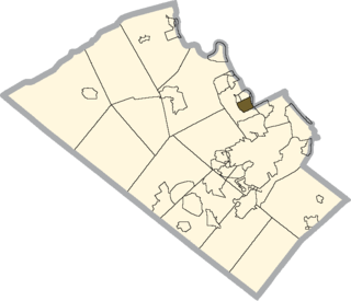
Heidelberg Township is a township in Lehigh County, Pennsylvania. The population of Heidelberg Township was 3,416 at the 2010 census. It is a suburb of Allentown in the Lehigh Valley, which had a population of 861,899 and was the 68th-most populous metropolitan area in the U.S. as of the 2020 census.

<span class="mw-page-title-main">Hokendauqua, Pennsylvania</span> Census-designated place in Pennsylvania, United States

Hokendauqua is an unincorporated community and census-designated place (CDP) in Whitehall Township in Lehigh County, Pennsylvania, United States. The population of Hokendauqua was 3,340 as of the 2020 census. Hokendauqua is a suburb of Allentown, Pennsylvania in the Lehigh Valley metropolitan area, which had a population of 861,899 and was the 68th-most populous metropolitan area in the U.S. as of the 2020 census.

<span class="mw-page-title-main">North Whitehall Township, Pennsylvania</span> Township in Pennsylvania, United States

North Whitehall Township is a township in Lehigh County, Pennsylvania, United States. The population of North Whitehall Township was 15,655 at the 2020 census. It is a suburb of Allentown in the Lehigh Valley, which had a population of 861,899 and was the 68th-most populous metropolitan area in the U.S. as of the 2020 census.

<span class="mw-page-title-main">Salisbury Township, Lehigh County, Pennsylvania</span> Township in Pennsylvania, United States

Salisbury Township is a township in Lehigh County, Pennsylvania, United States. The township's population was 13,621 at the 2020 census. The township borders Allentown, Pennsylvania's third-largest city, Bethlehem, and Emmaus, in the Lehigh Valley, which had a population of 861,899 and was the 68th-most populous metropolitan area in the U.S. as of the 2020 census.

<span class="mw-page-title-main">Upper Macungie Township, Pennsylvania</span> Township in Pennsylvania, United States

Upper Macungie Township is a township in Lehigh County, Pennsylvania, United States. The population of Upper Macungie Township was 26,377 as of the 2020 U.S. census, making it the fourth-fastest growing municipality of any category in Pennsylvania in terms of total population growth between 2010 and 2020.

<span class="mw-page-title-main">Washington Township, Lehigh County, Pennsylvania</span> Township in Pennsylvania, United States

Washington Township is a township in Lehigh County, Pennsylvania. The population of Washington Township was 6,624 at the 2010 census. It is a suburb of Allentown in the Lehigh Valley, which had a population of 861,899 and was the 68th-most populous metropolitan area in the U.S. as of the 2020 census.

<span class="mw-page-title-main">Mountain Top, Pennsylvania</span> Census-designated place in Pennsylvania, United States

Mountain Top is an unincorporated area and census-designated place (CDP) in Luzerne County, Pennsylvania, United States. As of the 2010 census, its population was 10,982.

<span class="mw-page-title-main">Belfast, Pennsylvania</span> CDP in Pennsylvania, United States

Belfast is a census-designated place (CDP) in Plainfield Township in Northampton County, Pennsylvania. It is part of the Lehigh Valley metropolitan area, which had a population of 861,899 and was the 68th-most populous metropolitan area in the U.S. as of the 2020 census. As of the 2010 census, the village's population was 1,257.

Eastlawn Gardens is a census-designated place (CDP) in Upper Nazareth Township in Northampton County, Pennsylvania. The population of Eastlawn Gardens was 3,307 at the 2010 census. Eastlawn Gardens is part of the Lehigh Valley metropolitan area, which had a population of 861,899 and was the 68th-most populous metropolitan area in the U.S. as of the 2020 census.

Middletown is a census-designated place (CDP) in Bethlehem Township in Northampton County, Pennsylvania. The population of Middletown was 7,441 at the 2010 census. Middletown is part of the Lehigh Valley, which had a population of 861,899 and was the 68th-most populous metropolitan area in the U.S. as of the 2020 census.

Elgin is an unincorporated community and census-designated place (CDP) in Lancaster County, South Carolina, United States. The population was 2,607 at the 2010 census.

<span class="mw-page-title-main">Utopia, Texas</span> Census-designated place in Texas, United States

Utopia is a census-designated place (CDP) in Uvalde County, Texas, United States. The population was 227 at the 2010 census.

Ghent is a census-designated place (CDP) in the town of Ghent in Columbia County, New York, United States. The population of the CDP was 477 at the 2022 survey, out of a total town population of 5,402.

<span class="mw-page-title-main">Trexlertown, Pennsylvania</span> Census-designated place in Pennsylvania, United States

Trexlertown is an unincorporated community and census-designated place (CDP) in Upper Macungie Township in Lehigh County, Pennsylvania. As of the 2020 census, the population was 2,382. It is part of the Lehigh Valley, which had a population of 861,899 and was the 68th-most populous metropolitan area in the U.S. as of the 2020 census, and lies between Breinigsville and Wescosville.

<span class="mw-page-title-main">Pocono Springs, Pennsylvania</span> Place in Pennsylvania, United States

Pocono Springs is a private community and census-designated place (CDP) in Lehigh and Sterling Townships in Wayne County, Pennsylvania, United States. The CDP's population was 926 at the time of the 2010 United States Census.

References

  1. "2019 U.S. Gazetteer Files: Places: Pennsylvania". United States Census Bureau. Retrieved October 27, 2020.
  2. 1 2 3 "Total Population: 2010 Census DEC Summary File 1 (P1), Schnecksville CDP, Pennsylvania". data.census.gov. U.S. Census Bureau. Retrieved October 27, 2020.
  3. "US Gazetteer files: 2010, 2000, and 1990". United States Census Bureau. February 12, 2011. Retrieved April 23, 2011.
  4. "U.S. Census website". United States Census Bureau . Retrieved January 31, 2008.
  5. "About" at Lehigh Carbon Community College