
Tariffville is a neighborhood and census-designated place (CDP) in the town of Simsbury in Hartford County, Connecticut, United States. The population was 1,324 at the 2010 census. It is a popular location for whitewater paddlers who use the Farmington River.
Noroton Heights is a village and census-designated place (CDP) in the town of Darien, Connecticut, United States. The community is located on Connecticut's Gold Coast. Located close to Long Island Sound, in the Connecticut panhandle, it is approximately 35 miles (56 km) northeast of Midtown Manhattan and immediately to the east of Stamford. As of the 2010 census, the CDP had a population of 7,916, at which time it included the area that is now part of the separate Noroton CDP.
Saugatuck is a census-designated place (CDP) in the town of Westport, Fairfield County, Connecticut, United States. It is in the southwest part of the town, on both sides of the Saugatuck River, extending south to where it enters Long Island Sound. North of Interstate 95, it occupies just the west side of the Saugatuck and continues north as far as U.S. Route 1. It is bordered to the north by Westport Village and to the west by the city of Norwalk. The CDP includes the communities of Owenoke and Saugatuck Shores, as well as the Metro-North Railroad Westport station.
Ridgebury is a census-designated place (CDP) in the town of Ridgefield, Fairfield County, Connecticut, United States. It occupies the north end of the town of Ridgefield and is bordered to the north and northeast by the city of Danbury and to the west by Putnam and Westchester counties in New York.

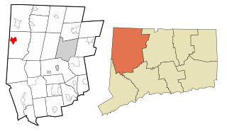
Canaan is a village and census-designated place (CDP) within the town of North Canaan in Litchfield County, Connecticut, United States. Formerly known as Canaan Depot, the village is more commonly known as Canaan Village to distinguish it from the town of Canaan located to the south of North Canaan. The Canaan Village Historic District is listed on the National Register of Historic Places. As of the 2010 census, the CDP had a population of 1,212, out of a total population of 3,315 in the town of North Canaan.

Canaan is a census-designated place comprising the main settlement in the town of Canaan, Essex County, Vermont, United States. As of the 2010 census, it had a population of 392, out of a total town population of 972.
Sharon is a census-designated place (CDP) in Litchfield County, Connecticut, United States. It is the primary village within the town of Sharon. As of the 2010 census, the population of the CDP was 729, out of 2,782 in the entire town.
Noroton is a census-designated place (CDP) in the town of Darien, Fairfield County, Connecticut, United States. It occupies the southwest part of Darien, from the Metro-North Railroad in the north to Long Island Sound in the south. The southern half of the community occupies Noroton Neck, between Holly Pond to the west and the Goodwives River to the east. It is bordered to the west by the city of Stamford and to the east by the Tokeneke neighborhood of Darien. To the north is Noroton Heights.
Rock Ridge is a census-designated place (CDP) in the town of Greenwich, Fairfield County, Connecticut, United States. It is in the western part of the town, just 1 mile (2 km) east of the New York state border. Rock Ridge was first listed as a CDP prior to the 2020 census.
Tokeneke is a census-designated place (CDP) in the town of Darien, Fairfield County, Connecticut, United States. It comprises the southeast part of the town, occupying several peninsulas and islands that extend into Long Island Sound, between the Goodwives River to the west and the Fivemile River to the east. It is bordered to the north by Darien Downtown and to the east by the city of Norwalk.
Poplar Plains is a census-designated place (CDP) in the town of Westport, Fairfield County, Connecticut, United States. It occupies the northwest corner of the town and is bordered to the southwest by the city of Norwalk, to the northwest by the town of Wilton, to the northeast by the town of Weston, to the east by the Saugatuck River, and to the south by the Merritt Parkway.
Staples is a census-designated place (CDP) in the town of Westport, Fairfield County, Connecticut, United States. It occupies the eastern side of the town and is bordered to the north by Cross Highway, to the west by Compo Road, to the south by U.S. Route 1, and to the east by the town of Fairfield.
Coleytown is a census-designated place (CDP) in the town of Westport, Fairfield County, Connecticut, United States. It occupies the northeast corner of the town and is bordered to the north by the town of Weston and to the east by the town of Fairfield.
Mill Plain is a census-designated place (CDP) in the town of Fairfield, Fairfield County, Connecticut, United States. It is in the southern part of the town, directly north of the downtown area of Fairfield and northeast of Southport. It is bordered to the west by the Mill River, to the south by Interstate 95, to the east by Mill Plain Road, and to the north by Duck Farm Road.
Stratford Downtown is a census-designated place (CDP) corresponding to the town center of Stratford, Fairfield County, Connecticut, United States. U.S. Route 1 runs east–west through the center of the CDP, and Interstate 95 forms the southeastern border, with access from Exit 32 at the southern limit of the CDP and from Exit 33 at the eastern limit. The Stratford Center Historic District falls outside the CDP, just to the south.
Oronoque is a census-designated place (CDP) in the town of Stratford, Fairfield County, Connecticut, United States. It is in the northern part of the town, bordered to the north by the city of Shelton, to the east by the Housatonic River, and to the south by the Merritt Parkway. Connecticut Route 110 runs north–south through the community. The administrative offices of Sikorsky Aircraft are in the eastern part of the CDP, between Route 110 and the Housatonic River.
Daniels Farm is a census-designated place (CDP) in the town of Trumbull, Fairfield County, Connecticut, United States. It is in the northeast part of Trumbull and is bordered to the northeast by the city of Shelton. The Connecticut Route 25 expressway forms the southwest edge of the CDP, and Route 111 forms the short northwest edge. The CDP extends south as far as Hedgehog Road, Old Dike Road, and Pinewood Trail. To the south is the Trumbull Center CDP.
Route 7 Gateway is a census-designated place (CDP) in the town of Ridgefield, Fairfield County, Connecticut, United States. It is on the east side of Ridgefield, bordered to the east by the town of Redding and to the northeast by the city of Danbury. U.S. Route 7 runs through the center of the CDP, leading north into Danbury and south to Norwalk. Connecticut Route 35 splits off Route 7 to the southwest in the center of the CDP, leading to the center of Ridgefield.
Lakes East is a census-designated place (CDP) in the town of Ridgefield, Fairfield County, Connecticut, United States. It is in the northeast part of the town and consists of neighborhoods sited around several small lakes, notably Wataba Lake in the north and Fox Hill Lake in the south.
Lakes West is a census-designated place (CDP) in the town of Ridgefield, Fairfield County, Connecticut, United States. It is in the northern part of the town on the north side of Ridgebury Mountain and extending north into a valley occupied by Lake Windwing. It is bordered to the east by the Lakes East CDP and to the northwest by Ridgebury.


