
Hanover is a town located along the Connecticut River in Grafton County, New Hampshire, United States. As of the 2020 census, its population was 11,870. The town is home to the Ivy League university Dartmouth College, the U.S. Army Corps of Engineers Cold Regions Research and Engineering Laboratory, and Hanover High School. The Appalachian Trail crosses the town, connecting with a number of trails and nature preserves.
Canaan is a town in Grafton County, New Hampshire, United States. The population was 3,794 at the 2020 census. It is the location of Mascoma State Forest. Canaan is home to the Cardigan Mountain School, the town's largest employer.
Durham is a census-designated place (CDP) comprising the primary village and surrounding development in the town of Durham, Middlesex County, Connecticut, United States. It is in the central and northeastern portions of the town, bordered to the north by the town of Middlefield and the city of Middletown. As of the 2020 census, the CDP had a population of 3,771, out of 7,152 in the entire town of Durham.
Portland is a census-designated place (CDP) comprising the primary village and adjacent residential land in the town of Portland, Middlesex County, Connecticut, United States. It is in the southwest part of the town, bordered to the west and south by the Connecticut River, which forms the border with Cromwell to the west and Middletown to the south. The Portland CDP extends north along Main Street to its junction with Gospel Lane at Fogelmarks Corners, and the eastern extent of the CDP is at Rose Hill Road and Collins Hill Road. The CDP includes the neighborhood of Gildersleeve in the north.
Mashantucket is a census-designated place (CDP) in the northeast part of the town of Ledyard, New London County, Connecticut, United States. It consists of land held by the Mashantucket Pequot Tribe. The Foxwoods Resort Casino is in the northeast part of the CDP, along Connecticut Route 2. As of the 2010 census, the CDP had a population of 299.

Lakeville is a census-designated place (CDP) in Litchfield County, Connecticut, United States, close to Dutchess County, New York. It is within the town of Salisbury, but has its own ZIP Code (06039). As of the 2010 census, the population of Lakeville was 928, out of 3,741 in the entire town of Salisbury. The Hotchkiss School is located in Lakeville, and the Indian Mountain School is nearby.
Falls Village is a village and census-designated place in the town of Canaan in Litchfield County, Connecticut, United States. As of the 2010 census it had a population of 538, out of 1,234 in the entire town of Canaan. Because Falls Village is the town center and principal constituent village in Canaan, the entire town is often referred to as "Falls Village". That usage also avoids confusion of the town with Canaan Village in the town of North Canaan, Connecticut, just to the north. Falls Village derives its name from a waterfall, known as Great Falls, on the Housatonic River within the village.

Wallingford Center is a census-designated place (CDP) comprising the primary community in the town of Wallingford, New Haven County, Connecticut, United States. It is in the central and southern parts of the town, bordered to the west by the Wilbur Cross Parkway, to the east by Interstate 91, and to the south by the town of North Haven. To the north the CDP extends to New Rock Hill Road, Durham Road, Christian Street, North Elm Street, Maplewood Avenue, and up North Main Street as far as Yale Avenue, where it crosses the Wilbur Cross Parkway. U.S. Route 5 is the main north–south road through the community. To the north is the neighborhood of Yalesville.

West Stewartstown is a census-designated place in the town of Stewartstown in Coös County, New Hampshire, United States. It had a population of 263 at the 2020 census, down from 386 at the 2010 census.
Canaan is a census-designated place (CDP) and the main village in the town of Canaan in Grafton County, New Hampshire, United States. The population of the CDP was 442 at the 2020 census, out of 3,794 in the entire town.

Canaan is a village and census-designated place (CDP) within the town of North Canaan in Litchfield County, Connecticut, United States. Formerly known as Canaan Depot, the village is more commonly known as Canaan Village to distinguish it from the town of Canaan located to the south of North Canaan. The Canaan Village Historic District is listed on the National Register of Historic Places. As of the 2010 census, the CDP had a population of 1,212, out of a total population of 3,315 in the town of North Canaan.

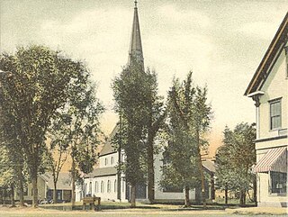
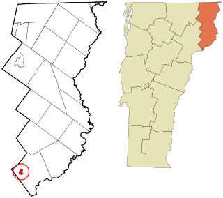
Canaan is a census-designated place comprising the main settlement in the town of Canaan, Essex County, Vermont, United States. As of the 2010 census, it had a population of 392, out of a total town population of 972.
Concord is a census-designated place comprising the main settlement in the town of Concord, Essex County, Vermont, United States. As of the 2010 census, it had a population of 271, out of a total town population of 1,235.

Norfolk is a census-designated place (CDP) in Litchfield County, Connecticut, United States. It is the central village within the town of Norfolk. As of the 2010 census, the population of the CDP was 553, out of 1,709 in the entire town.
Murray is a census-designated place (CDP) in the town of Fairfield, Fairfield County, Connecticut, United States. It is in the northern part of Fairfield, with Burr Street running north–south through the center of the CDP. The Merritt Parkway crosses the CDP from east to west, with access from Exit 44 at the eastern edge of the community.
Stratford Downtown is a census-designated place (CDP) corresponding to the town center of Stratford, Fairfield County, Connecticut, United States. U.S. Route 1 runs east–west through the center of the CDP, and Interstate 95 forms the southeastern border, with access from Exit 32 at the southern limit of the CDP and from Exit 33 at the eastern limit. The Stratford Center Historic District falls outside the CDP, just to the south.
Oronoque is a census-designated place (CDP) in the town of Stratford, Fairfield County, Connecticut, United States. It is in the northern part of the town, bordered to the north by the city of Shelton, to the east by the Housatonic River, and to the south by the Merritt Parkway. Connecticut Route 110 runs north–south through the community. The administrative offices of Sikorsky Aircraft are in the eastern part of the CDP, between Route 110 and the Housatonic River.
East Village is a census-designated place (CDP) in the town of Monroe, Fairfield County, Connecticut, United States. It occupies the northeast end of the town of Monroe, extending northeast to the Housatonic River and southwest to Walnut Street. It is bordered to the southeast by the city of Shelton and to the northwest by the town of Newtown.

Ball Pond is a census-designated place (CDP) in the town of New Fairfield, Fairfield County, Connecticut, United States. It is in the southwest part of the town, with the pond of the same name in the central part of the CDP. The community is bordered to the south by Taylor Corners and to the west by Putnam Lake in Putnam County, New York.

Bridgewater is a census-designated place (CDP) comprising the populated center of the town of Bridgewater, Litchfield County, Connecticut, United States. It is in the north-central part of the town, around the intersection of Connecticut Routes 133 and 867. It includes the Bridgewater Center Historic District.


