Georgetown, Connecticut

Last updated

Georgetown, Connecticut
Fairfield County Connecticut incorporated and unincorporated areas Georgetown highlighted.svg
Location in Fairfield County and the state of Connecticut.
Coordinates: 41°15′24″N73°26′1″W / 41.25667°N 73.43361°W / 41.25667; -73.43361
Country Flag of the United States.svg  United States
U.S. state Flag of Connecticut.svg  Connecticut
County Fairfield
Region Western CT
NECTA Bridgeport-Stamford-Norwalk
Towns Redding, Weston, Wilton, Ridgefield
Area
  Total2.89 sq mi (7.5 km2)
  Land2.87 sq mi (7.4 km2)
  Water0.02 sq mi (0.05 km2)
Elevation
354 ft (108 m)
Population
 (2020) [1]
  Total1,832
  Density638/sq mi (246/km2)
Time zone UTC-5 (Eastern (EST))
  Summer (DST) UTC-4 (EDT)
ZIP code
06829
Area code 203
FIPS code 09-30540
GNIS feature ID0207283

Georgetown is a census-designated place in Fairfield County, Connecticut, United States. It is located in the area where the towns of Wilton, Redding, Weston, and Ridgefield meet. [2]

Contents

Georgetown and its surrounding area are also defined as the Georgetown census-designated place (CDP). As of the 2020 census, the population of the CDP was 1,832. [1]

Georgetown is located at the southwest corner of the town of Redding, the northwest corner of the town of Weston, the northeast corner of the town of Wilton, and the southeast corner of Ridgefield. [3] Georgetown residents officially live in and pay local taxes to one of these four towns, but typically identify themselves as living in Georgetown. Georgetown has its own fire district, which also serves the surrounding rural areas not traditionally included in Georgetown, and its own ZIP code (06829).

Historic district

On April 9, 1987, the central portion of Georgetown was listed on the U.S. National Register of Historic Places as the Georgetown Historic District. A map shows its approximate location within Georgetown. [4] The historic district is an area of 90 acres (360,000 m2) that includes the Gilbert and Bennett manufacturing plant, institutional housing built for the plant workers, and other private homes. The district includes portions of Georgetown in the towns of Redding and Wilton. [5]

Geography

Map of the Georgetown CDP Georgetown, connecticut map.gif
Map of the Georgetown CDP

According to the United States Census Bureau, the CDP has a total area of 2.85 square miles (7.4 km2), of which 2.84 square miles (7.4 km2) is land and 0.02 square miles (0.052 km2), or 0.70%, is water. Of the total area of the CDP, 2.36 square miles (6.1 km2) are in Wilton, 0.33 square miles (0.85 km2) are in Redding, and 0.16 square miles (0.41 km2) are in Weston.

Demographics

Georgetown on Clark's map of Fairfield County, published in 1856 Georgetown, Fairfield County, Connecticut, Clark 1856.jpg
Georgetown on Clark's map of Fairfield County, published in 1856

As of the census [6] of 2000, there were 1,650 people, 572 households, and 455 families residing in the CDP. The population density was 581.8 inhabitants per square mile (224.6/km2). There were 597 housing units at an average density of 210.5 per square mile (81.3/km2). The racial makeup of the CDP was 90.62% White, 1.33% African American, 0.24% Native American, 3.39% Asian, 0.48% from other races, and 0.55% from two or more races. Hispanic or Latino of any race were 3.39% of the population.

There were 572 households, out of which 44.9% had children under the age of 18 living with them, 71.0% were married couples living together, 4.7% had a female householder with no husband present, and 20.3% were non-families. 16.3% of all households were made up of individuals, and 5.9% had someone living alone who was 65 years of age or older. The average household size was 2.87 and the average family size was 3.27.

In the CDP, the population was spread out, with 30.4% under the age of 18, 3.3% from 18 to 24, 29.9% from 25 to 44, 27.7% from 45 to 64, and 8.7% who were 65 years of age or older. The median age was 38 years. For every 100 females, there were 100.0 males. For every 100 females age 18 and over, there were 99.1 males.

The median income for a household in the CDP was $103,424, and the median income for a family was $110,081. Males had a median income of $81,538 versus $59,531 for females. The per capita income for the CDP was $55,029. About 2.0% of families and 4.7% of the population were below the poverty line, including 3.5% of those under age 18 and 4.6% of those age 65 or over.

Movies filmed in Georgetown

Pictures

See also

Related Research Articles

<span class="mw-page-title-main">Redding, Connecticut</span> Town in Connecticut, United States

Redding is a town in Fairfield County, Connecticut, United States. The population was 8,765 at the 2020 census. The town is part of the Western Connecticut Planning Region.

<span class="mw-page-title-main">Wilton, Connecticut</span> Town in Connecticut, United States

Wilton is a town in Fairfield County, Connecticut, United States. As of the 2020 census, the town population was 18,503. The town is part of the Western Connecticut Planning Region.

<span class="mw-page-title-main">Tariffville, Connecticut</span> Census-designated place in Connecticut, United States

Tariffville is a neighborhood and census-designated place (CDP) in the town of Simsbury in Hartford County, Connecticut, United States. The population was 1,324 at the 2010 census. It is a popular location for whitewater paddlers who use the Farmington River.

<span class="mw-page-title-main">Bethlehem, Connecticut</span> Town in Connecticut, United States

Bethlehem is a town in Litchfield County, Connecticut, United States. The population was 3,385 at the 2020 census, down from 3,607 at the 2010 census. The town is part of the Naugatuck Valley Planning Region. The town center is a historic district and a census-designated place (CDP).

<span class="mw-page-title-main">Deep River, Connecticut</span> Town in Connecticut, United States

Deep River is a town in Middlesex County, Connecticut. The town is part of the Lower Connecticut River Valley Planning Region. The population was 4,415 at the 2020 census. The town center is designated by the U.S. Census Bureau as a census-designated place (CDP). Deep River is part of what the locals call the "Tri-town Area", made up of the towns of Deep River, Chester, and Essex.

<span class="mw-page-title-main">Higganum, Connecticut</span> Census-designated place in Connecticut, United States

Higganum is a village and census-designated place (CDP) in the town of Haddam, a part of Middlesex County, Connecticut, United States. The population was 2,089 at the 2020 census.

<span class="mw-page-title-main">Westbrook, Connecticut</span> Town in Connecticut, United States

Westbrook is a town in Middlesex County, Connecticut, United States. The town is part of the Lower Connecticut River Valley Planning Region. The population was 6,769 at the 2020 census. The town center is classified by the U.S. Census Bureau as a census-designated place (CDP).

<span class="mw-page-title-main">Noank, Connecticut</span> Census-designated place in Connecticut, United States

Noank is a village in the town of Groton, Connecticut. This dense community of historic homes and local businesses sits on a small, steep peninsula at the mouth of the Mystic River with a long tradition of fishing, lobstering and boat-building. The village is listed as a historic district on the National Register of Historic Places and is the home of multiple seaside lobster shacks and oyster aquaculture operations. The population was 1,796 at the 2010 census.

<span class="mw-page-title-main">Somers, Connecticut</span> Town in Connecticut, United States

Somers is a town in Tolland County, Connecticut. The town is part of the Capitol Planning Region. The population was 10,255 at the 2020 census. The town center is listed by the U.S. Census Bureau as a census-designated place (CDP). In 2007, Money Magazine listed Somers 53rd on its "100 Best Places to Live", based on "economic opportunity, good schools, safe streets, things to do and a real sense of community."

<span class="mw-page-title-main">Simsbury Center, Connecticut</span> Census-designated place in Connecticut, United States

Simsbury Center is a census-designated place (CDP) that consists of the central settlement, and the neighborhoods immediately surrounding it, in the town of Simsbury, Connecticut, in the United States. As of the 2010 census, the CDP had a population of 5,836. The core area of the CDP is listed as the Simsbury Center Historic District on the National Register of Historic Places.

<span class="mw-page-title-main">South Hooksett, New Hampshire</span> Census-designated place in New Hampshire, United States

South Hooksett is a census-designated place (CDP) within the town of Hooksett in Merrimack County, New Hampshire, United States. The population was 5,888 at the 2020 census. It is a suburban area adjacent to the city of Manchester, New Hampshire's largest city, and includes a mix of housing developments and large retail stores.

<span class="mw-page-title-main">Lewisboro, New York</span> Town in New York, United States

Lewisboro is a town in Westchester County, New York, United States. The population was 12,411 at the 2010 census. The town is named after John Lewis, an early settler. Lewisboro is a suburb of New York City.

<span class="mw-page-title-main">Lasana, Texas</span> Census-designated place in Texas, United States

Lasana is a census-designated place (CDP) in Cameron County, Texas, United States. The population was 84 at the 2010 census, down from 135 at the 2000 census. It is part of the Brownsville–Harlingen Metropolitan Statistical Area.

<span class="mw-page-title-main">Ridgefield (CDP), Connecticut</span> Census-designated place in Connecticut, United States

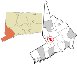
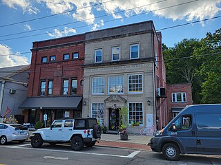
Ridgefield is a census-designated place (CDP) in Fairfield County, Connecticut, United States. It consists of the primary central village in the town of Ridgefield and surrounding residential areas. As of the 2020 census, the population of the CDP was 7,596, out of 25,053 in the entire town.

<span class="mw-page-title-main">Ridgefield, Connecticut</span> Town in Connecticut, United States

Ridgefield is a town in Fairfield County, Connecticut, United States. Situated in the foothills of the Berkshire Mountains and on the New York state border, Ridgefield has a population of 25,033 as of the 2020 census. The town is part of the Western Connecticut Planning Region. The town center, which was formerly a borough, is defined by the U.S. Census Bureau as a census-designated place. The town was settled then quickly incorporated by 1709.

<span class="mw-page-title-main">Durham, Connecticut</span> Town in Connecticut, United States

Durham is a town in Middlesex County, Connecticut, United States. Durham is a former farming village on the Coginchaug River in central Connecticut. The town is part of the Lower Connecticut River Valley Planning Region. The population was 7,152 at the 2020 census. Every autumn, the town hosts the Durham Fair, the largest volunteer agricultural fair in New England.

<span class="mw-page-title-main">Canaan (village), Connecticut</span> United States historic place

Canaan is a village and census-designated place (CDP) within the town of North Canaan in Litchfield County, Connecticut, United States. Formerly known as Canaan Depot, the village is more commonly known as Canaan Village to distinguish it from the town of Canaan located to the south of North Canaan. The Canaan Village Historic District is listed on the National Register of Historic Places. As of the 2010 census, the CDP had a population of 1,212, out of a total population of 3,315 in the town of North Canaan.

<span class="mw-page-title-main">Clinton, Connecticut</span> Town in Connecticut, United States

Clinton is a town in Middlesex County, Connecticut, United States. The town is part of the Lower Connecticut River Valley Planning Region. The population of the town was 13,185 at the 2020 census. The town center along the shore line was listed as a census-designated place (CDP) by the U.S. Census Bureau in the 2020 census.

<span class="mw-page-title-main">East Hampton, Connecticut</span> Town in Connecticut, United States

East Hampton is a town in Middlesex County, Connecticut, United States. The town is part of the Lower Connecticut River Valley Planning Region. The population was 12,717 at the 2020 census. The town center village is listed as a census-designated place (CDP). East Hampton includes the communities of Cobalt, Middle Haddam, and Lake Pocotopaug.

<span class="mw-page-title-main">Greenwich (CDP), Connecticut</span> Census-designated place in Connecticut, United States

Greenwich is a census-designated place (CDP) in Fairfield County, Connecticut, United States. It is one of several CDPs within the town of Greenwich and corresponds to the historic municipal center of the town and surrounding residential and commercial areas. As of the 2010 census, the population of the Greenwich CDP was 12,942, out of 61,171 in the entire town.

References

  1. 1 2 "Census - Geography Profile: Georgetown CDP, Connecticut" . Retrieved August 7, 2023.
  2. "Georgetown · Wilton, CT". Georgetown · Wilton, CT. Retrieved January 12, 2023.
  3. "Georgetown · Wilton, CT". Georgetown · Wilton, CT. Retrieved January 12, 2023.
  4. Google-based map showing approximate boundaries of Georgetown CDP and of Georgetown Historic District within it
  5. Jan Cunningham and John Herzan (June 25, 1986). "National Register of Historic Places Inventory-Nomination: Georgetown Historic District". National Park Service. and Accompanying 25 photos, from 1986
  6. "U.S. Census website". United States Census Bureau . Retrieved January 31, 2008.
  7. Internet Movie DataBase page for Georgetown, Connecticut, accessed on July 3, 2006

41°15′20″N73°26′05″W / 41.25556°N 73.43472°W / 41.25556; -73.43472