Branchville, Connecticut

Last updated

Branchville, Connecticut
JHTwachtmanBranchville.jpg
Branchville (ca. 1888-1889) by John Henry Twachtman (1853-1902)
Country Flag of the United States.svg  United States
State Flag of Connecticut.svg  Connecticut
County Fairfield
City Ridgefield
Time zone UTC-5:00 (Eastern)
  Summer (DST) UTC-4:00 (Eastern)
Area code(s) 203

Branchville is a neighborhood of the town of Ridgefield in Fairfield County, Connecticut, United States, and is also the name of a Metro North railroad station (Branchville station). [1] Branchville was listed as a census-designated place (CDP) prior to the 2020 census. [2]

Contents

Some people consider Branchville a part of Georgetown, an adjoining, non-incorporated community at the intersection of Redding, Ridgefield, Wilton and Weston, noting many residences and businesses there share Georgetown's 544- telephone number exchange. Others disagree, pointing to a community vote in the 1950s not to be served by the Georgetown Post Office, which is closer than the Ridgefield Post Office. The Branchville CDP is only in the town of Ridgefield.

History

Branchville was named for the Danbury and Norwalk Railroad's “branch” line extending west to Ridgefield village, [3] a four-mile (6.4 km) run on a long incline [Branchville's elevation is 342 feet (104 m) [4] while the old village station was about 900 feet (270 m) above sea level].

Native Americans had previously referred to the southeast corner of present-day Ridgefield as Wheer Cock. [5] Later it was called Copps Corner, after the Norwalk man who surveyed the town in the early 18th century and was the first town clerk. [6] When workers completed in 1852 the railroad line from Norwalk to Danbury, the neighborhood was at first called Beers Station or Ridgefield Station, after the stop there. [7]

The first recorded use of the term Branchville appears in an 1870 deed for 4 acres (16,000 m2) “lying in the town of Ridgefield at Branchville.” It was the same year that the branch line was built, suggesting that the railroad rather than neighborhood residents had invented the name to distinguish the station from the new one at Ridgefield center. Previously, the station at Branchville had been known as Ridgefield Station or Beers Station.

An 1893 atlas labels this territory as “Plattsville,” possibly a mapmaker’s error.

While the area had been mostly farmland and a mill or two, the coming of the railroad sparked the development of a booming, albeit small-scale, industrial community. It included mills, stores, a hotel, a machinery factory, and a post office.

In 1876, after A.N. Fillow began extracting mica at Branchville, two Yale University mineralogists noted the presence of previously undiscovered minerals lodged in pegmatite there and furnished funds to expand the operation. Historians say the mine produced between seven [8] and nine minerals until then unknown. Over time, the mine would produce quantities of quartz, feldspar, mica, beryl, spodumene and columbite. [9]

Passenger service on the Ridgefield branch line continued until 1925; freight service lasted until 1964. Most of the track bed, complete with gravel but missing its rails, is today the path of the Eversource Energy high-voltage line and the town’s “Rail-Trail,” developed in the 1990s for walkers. Some of the other sections along southern Florida Road have been sold to adjoining landowners.

Education

Branchville had its own school district at least since the middle 18th century – it was known as the “Ridgefield Station District” before it was called Branchville. Its schoolhouse was used until around fall of 1937 when children started being bused to Garden School on Bailey Avenue in the village.

A new Branchville School opened in 1969 on lower Florida Road, remaining in use until in 1983 when it was closed due to declining enrollments and used as Ridgefield Board of Education offices. In 1994, faced with increasing enrollments, voters agreed to reopen the school.

Weir Farm

Branchville Fields by John Henry Twachtman, ca. 1888 TwachtmanBranchvilleFields.jpg
Branchville Fields by John Henry Twachtman, ca. 1888

Weir Farm National Historic Site in Ridgefield and Wilton is considered part of Branchville. Administered by the National Park Service, Weir Farm commemorates the life and work of impressionist painter Julian Alden Weir and other artists who stayed at the site, [10] with notable visitors having included Childe Hassam, Albert Pinkham Ryder, John Singer Sargent and John Twachtman. [11] Artist Sperry Andrews would later lead efforts to preserve the Weir Farm site, with the U.S. government designating it a National Historic Site in 1990. [12]

In 1882, Weir acquired a 153-acre farm from Erwin Davis in exchange for $10 and a painting. [13] Weir and artists he hosted subsequently produced a large number of paintings depicting Branchville and surrounding landscapes. [14]

Weir Farm is slated to represent Connecticut on a commemorative quarter to be issued in 2020 by the U.S. Mint. [15]

Related Research Articles

<span class="mw-page-title-main">Fairfield County, Connecticut</span> County in Connecticut, United States

Fairfield County is a county in the southwestern corner of the U.S. state of Connecticut. It is the most populous county in the state and was also its fastest-growing from 2010 to 2020. As of the 2020 census, the county's population was 957,419, representing 26.6% of Connecticut's overall population. The closest to the center of the New York metropolitan area, the county contains four of the state's top 7 largest cities—Bridgeport (1st), Stamford (2nd), Norwalk (6th), and Danbury (7th)—whose combined population of 433,368 is nearly half the county's total population.

<span class="mw-page-title-main">Georgetown, Connecticut</span> Census-designated place in Connecticut, United States

Georgetown is a census-designated place in Fairfield County, Connecticut, United States. It is located in the area where the towns of Wilton, Redding, Weston, and Ridgefield meet.

<span class="mw-page-title-main">Redding, Connecticut</span> Town in Connecticut, United States

Redding is a town in Fairfield County, Connecticut, United States. The population was 8,765 at the 2020 census. The town is part of the Western Connecticut Planning Region.

<span class="mw-page-title-main">Wilton, Connecticut</span> Town in Connecticut, United States

Wilton is a town in Fairfield County, Connecticut, United States. As of the 2020 census, the town population was 18,503. The town is part of the Western Connecticut Planning Region.

<span class="mw-page-title-main">Ridgefield (CDP), Connecticut</span> Census-designated place in Connecticut, United States

Ridgefield is a census-designated place (CDP) in Fairfield County, Connecticut, United States. It consists of the primary central village in the town of Ridgefield and surrounding residential areas. As of the 2010 census, the population of the CDP was 7,645, out of 24,638 in the entire town.

<span class="mw-page-title-main">Ridgefield, Connecticut</span> Town in Connecticut, United States

Ridgefield is a town in Fairfield County, Connecticut, United States. Situated in the foothills of the Berkshire Mountains, the 300-year-old community had a population of 25,033 at the 2020 census. The town is part of the Western Connecticut Planning Region. The town center, which was formerly a borough, is defined by the U.S. Census Bureau as a census-designated place.

<span class="mw-page-title-main">Danbury Branch</span> Metro-North Railroad branch in Connecticut

The Danbury Branch is a diesel branch of the Metro-North Railroad's New Haven Line in the U.S. state of Connecticut, running from downtown Norwalk north to Danbury. It opened in 1852 as the Danbury and Norwalk Railroad. Until the early 1970s, passenger service continued north from Danbury to Canaan, Connecticut, and Pittsfield, Massachusetts. Metro-North took over operation of the line from Conrail in 1983, and the modern-day branch is mostly single-tracked.

<span class="mw-page-title-main">Danbury and Norwalk Railroad</span> American railroad

The Danbury and Norwalk Railroad, chartered in 1835 as the Fairfield County Railroad, was an independent American railroad that operated between the cities of Danbury and Norwalk, Connecticut from 1852 until its absorption by the Housatonic Railroad in 1886. The right of way established by the D&N continues in operation and is now the Danbury Branch of the New Haven Line of the Metro-North Railroad.

<span class="mw-page-title-main">Weir Farm National Historical Park</span> Historic site in Fairfield County, Connecticut

Weir Farm National Historical Park is located in Ridgefield and Wilton, Connecticut. It commemorates the life and work of American impressionist painter J. Alden Weir and other artists who stayed at the site or lived there, to include Childe Hassam, Albert Pinkham Ryder, John Singer Sargent, and John Twachtman.

<span class="mw-page-title-main">Branchville station</span> Metro-North Railroad station in Connecticut

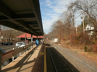
Branchville station is a commuter rail station on the Danbury Branch of the Metro-North Railroad New Haven Line, located in the Branchville neighborhood of Ridgefield, Connecticut.

<span class="mw-page-title-main">Housatonic Area Regional Transit</span> Transportation provider in Danbury, Connecticut

Housatonic Area Regional Transit, known popularly as HARTransit, is the provider of public transportation for Danbury, Connecticut and surrounding communities. HARTransit was founded in 1972 as the Danbury-Bethel Transit District by the two municipalities. The name was changed to Housatonic Area Regional Transit in 1979 after the addition of other municipal members. The agency receives funding from municipal contracts, the Connecticut Department of Transportation, Federal Transit Administration and the New York State Department of Transportation. Prior to HARTransit's establishment, Danbury had gone without transit service since 1967 when the privately owned ABC Bus Company which had replaced the Candlewood Bus Company a few months before, ceased operations. The first local bus transit operator in the area, Danbury Power & Transportation Company, operated bus services in Danbury and Bethel from 1926 to 1965. HARTransit provides service to a greater number of towns than its predecessors.

<span class="mw-page-title-main">Greater Bridgeport</span> Metropolitan statistical area in Connecticut, United States

Greater Bridgeport is the metropolitan area centered on the city of Bridgeport in the U.S. state of Connecticut. The area is located in Southwestern Connecticut. In its most conservative form the area consists of the city of Bridgeport and five surrounding towns—Easton, Fairfield, Monroe, Stratford, and Trumbull. This definition of the Bridgeport area has a population of more than 305,000 and is within the Bridgeport-Stamford-Norwalk-Danbury metropolitan statistical area, which consists of all of Fairfield County, Connecticut. The estimated 2015 county population was 948,053. The area is numbered as part of the New York-Newark Combined Statistical Area NY-NJ-CT-PA by the United States Census Bureau.

<span class="mw-page-title-main">Connecticut Route 102</span> State highway in Fairfield County, Connecticut, US

Route 102 is a state highway in southwestern Connecticut running from the center of Ridgefield to the Branchville section of the same town.

<span class="mw-page-title-main">Georgetown Historic District (Georgetown, Connecticut)</span> Historic district in Connecticut, United States

The Georgetown Historic District is a historic district which covers the central portion the village of Georgetown, Connecticut. The district includes parts of Georgetown in the towns of Redding, Weston, Wilton, and Ridgefield and consists of the former Gilbert & Bennett manufacturing plant, institutional housing built for the plant workers, other private homes, and the Georgetown business district.

The Ridgefield Rail Trail is a rail trail in Ridgefield, Connecticut. It follows an old rail corridor for 2.3 miles (3.7 km) from downtown Ridgefield to the Branchville section of town.

<span class="mw-page-title-main">Kent Road station</span> Metro-North Railroad station in Connecticut

Kent Road station was a commuter rail stop on the Danbury Branch of the Metro-North Railroad's New Haven Line. It was located near the border between Wilton and Norwalk, south of a grade crossing with Kent Road in Wilton, Connecticut. It opened in 1976 and closed in 1994. A previous station on the site, South Wilton, closed in 1971.

<span class="mw-page-title-main">Georgetown station (Connecticut)</span> Former railway station in Georgetown, Connecticut

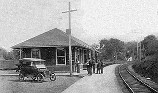
Georgetown station is a former commuter rail station on the Danbury Division of the New York, New Haven, and Hartford Railroad, located in Georgetown, Connecticut. It was in service from 1852 to 1970. A new station at Georgetown has been proposed.

<span class="mw-page-title-main">Cooper station (Connecticut)</span> US railroad station, c. 1885–1925

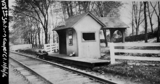
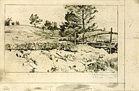
Cooper station was a stop on the Ridgefield Branch of the Danbury and Norwalk Railroad and later the New York, New Haven, and Hartford Railroad. Opened circa 1885 as a flag stop in the town of Ridgefield, Connecticut, the station was closed in 1925 when passenger service on the Ridgefield branch was discontinued. The station existed alongside the Florida and Ridgefield stations along the branch. Cooper was named so due to the namesake street it was located on which was in turn named for an unidentified cooper who operated a workshop in the vicinity.

<span class="mw-page-title-main">Sanford station (Connecticut)</span> Train station in Redding, Connecticut, USA

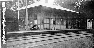
Sanford station was a passenger rail station on the Danbury and Norwalk Railroad and later the Danbury Branch of both the Housatonic Railroad and the New York, New Haven, and Hartford Railroad. The station was located on the border between Ridgefield and Redding, Connecticut, and was located on Topstone Road. Opened in 1852 as a flag stop and located in the Topstone section of Redding, Connecticut, the original station building was destroyed in 1891 by a speeding freight train. A new station building was erected the following year and would serve until the station's closure in 1938. The station was called so because of the numerous families named Sanford in the area surrounding the station.

<span class="mw-page-title-main">Ridgefield Branch</span>

The Ridgefield Branch was a branch line of the Danbury and Norwalk Railroad and later the New York, New Haven and Hartford Railroad. It ran for 4.0 miles (6.4 km) from Branchville to the center of Ridgefield, Connecticut. After a difficult and costly construction hindered by the topography of the Norwalk River valley, the branch opened in July 1870 after a year of construction. Throughout its existence, three stations existed on the line. In 1925, amid electrification of the neighboring Danbury Line, passenger service on the branch was terminated. Freight service continued to just the Ridgefield station until 1964, when the line was abandoned entirely.

References

  1. http://m.mta.info/mt/as0.mta.info/mnr/stations/station_detail.cfm?key=274 Archived 2014-05-02 at the Wayback Machine "Branchville," MTA.com. Retrieved 2014-05-02.
  2. "Branchville Census Designated Place". Geographic Names Information System . United States Geological Survey, United States Department of the Interior.
  3. "Hvceo - History of Rail Lines in the Housatonic Valley, Ct Region". Archived from the original on January 29, 2008. Retrieved March 19, 2008. "Danbury Branch Rail Line History," Housatonic Valley Council of Elected Officials. Retrieved 2014-05-02.
  4. http://www.theridgefieldpress.com/25484/when-trains-ran-up-to-town/ Archived 2014-05-02 at the Wayback Machine "When trains ran up to town," Ridgefield Press, 2014-01-26. Retrieved 2014-05-02.
  5. Teller, Daniel Webster (1878). The History of Ridgefield, Conn: From Its First Settlement to the Present Time. T. Donovan.
  6. "Ridgefield Place Names beginning with C". jackfsanders.tripod.com. Retrieved July 29, 2022.
  7. "historyofredding.com". ww38.historyofredding.com. Retrieved July 29, 2022.
  8. http://connecticutexplored.org/wordpress/wp-content/uploads/2010/09/CONNECTICUT-EXPLORED_CONNECTICUT_PEGAMITE.pdf Archived 2014-05-02 at the Wayback Machine Pawloski, John A. Sr., "The Industrial Might of Connecticut Pegmatite," Connecticut Explored, Vol. 8 No. 3, Summer 2010.
  9. "Branchville Connecticut Pegmatite". www.minsocam.org. Retrieved July 29, 2022.
  10. Wilton, Mailing Address: 735 Nod Hill Road; Us, CT 06897 Phone: 203 834-1896 x0 Contact. "Weir Farm National Historical Park (U.S. National Park Service)". www.nps.gov. Retrieved July 29, 2022.
  11. Wilton, Mailing Address: 735 Nod Hill Road; Us, CT 06897 Phone: 203 834-1896 x0 Contact. "Artwork Galleries - Weir Farm National Historical Park (U.S. National Park Service)". www.nps.gov. Retrieved July 29, 2022.
  12. Potts, Monica (August 16, 2005). "Sperry Andrews, 87, Painter Who Preserved Weir Home, Is Dead". The New York Times. ISSN   0362-4331 . Retrieved July 29, 2022.
  13. Wilton, Mailing Address: 735 Nod Hill Road; Us, CT 06897 Phone: 203 834-1896 x0 Contact. "Julian Alden Weir - Weir Farm National Historical Park (U.S. National Park Service)". www.nps.gov. Retrieved July 29, 2022.
  14. http://www.nps.gov/history/history/online_books/wefa/clr.pdf "Cultural Landscape Program for Weir Farm National Historic Site," Olmsted Center for Landscape Preservation, National Park Service. Retrieved 2014-05-02.
  15. "America the Beautiful Quarters® Program | U.S. Mint". www.usmint.gov. June 6, 2016. Retrieved July 29, 2022.

41°16′03″N73°26′30″W / 41.26750°N 73.44167°W / 41.26750; -73.44167