Fairfield County is a county in the southwestern corner of the U.S. state of Connecticut. It is the most populous county in the state and was also its fastest-growing from 2010 to 2020. As of the 2020 census, the county's population was 957,419, representing 26.6% of Connecticut's overall population. The closest to the center of the New York metropolitan area, the county contains four of the state's top 7 largest cities—Bridgeport (1st), Stamford (2nd), Norwalk (6th), and Danbury (7th)—whose combined population of 433,368 is nearly half the county's total population.

Wilton is a town in Fairfield County, Connecticut, United States. As of the 2020 census, the town population was 18,503. The town is part of the Western Connecticut Planning Region.

Carmel is a town in Putnam County, New York, United States. As of the 2020 United States census, the town had a population of 33,576. The town may have been named after Mount Carmel in Israel.
Danbury is a city in Fairfield County, Connecticut, located approximately 50 miles (80 km) northeast of New York City. Danbury's population as of 2020 was 86,518. It is the third-largest city in Western Connecticut, and the seventh-largest city in Connecticut.

Ridgefield is a town in Fairfield County, Connecticut, United States. Situated in the foothills of the Berkshire Mountains, Ridgefield has a population of 25,033 as of the 2020 census. The town is part of the Western Connecticut Planning Region. The town center, which was formerly a borough, is defined by the U.S. Census Bureau as a census-designated place. The town was settled then quickly incorporated by 1709.

The Danbury Branch is a diesel branch of the Metro-North Railroad's New Haven Line in the U.S. state of Connecticut, running from downtown Norwalk north to Danbury. It opened in 1852 as the Danbury and Norwalk Railroad. Until the early 1970s, passenger service continued north from Danbury to Canaan, Connecticut, and Pittsfield, Massachusetts. Metro-North took over operation of the line from Conrail in 1983, and the modern-day branch is mostly single-tracked.

The Danbury and Norwalk Railroad, chartered in 1835 as the Fairfield County Railroad, was an independent American railroad that operated between the cities of Danbury and Norwalk, Connecticut from 1852 until its absorption by the Housatonic Railroad in 1886. The right of way established by the D&N continues in operation and is now the Danbury Branch of the New Haven Line of the Metro-North Railroad.

Route 35 is a state highway in Connecticut, located entirely within the town of Ridgefield, Fairfield County. Route 35 starts at the New York state line, where the road continues as New York State Route 35, and ends at U.S. Route 7. The road is often used as an alternative to the congested Route 7. Originally part of New England Route 3 in the 1920s, Route 35 was designated in 1932.

Housatonic Area Regional Transit, known popularly as HARTransit, is the provider of public transportation for Danbury, Connecticut and surrounding communities. HARTransit was founded in 1972 as the Danbury-Bethel Transit District by the two municipalities. The name was changed to Housatonic Area Regional Transit in 1979 after the addition of other municipal members. The agency receives funding from municipal contracts, the Connecticut Department of Transportation, Federal Transit Administration and the New York State Department of Transportation. Prior to HARTransit's establishment, Danbury had gone without transit service since 1967 when the privately owned ABC Bus Company which had replaced the Candlewood Bus Company a few months before, ceased operations. The first local bus transit operator in the area, Danbury Power & Transportation Company, operated bus services in Danbury and Bethel from 1926 to 1965. HARTransit provides service to a greater number of towns than its predecessors.

Branchville is a neighborhood of the town of Ridgefield in Fairfield County, Connecticut, United States, and is also the name of a Metro North railroad station. Branchville was listed as a census-designated place (CDP) prior to the 2020 census.

The Main Street Historic District in Danbury, Connecticut, United States, is the oldest section of that city, at its geographical center. It has long been the city's commercial core and downtown. Its 132 buildings, 97 of which are considered contributing properties, include government buildings, churches, commercial establishments and residences, all in a variety of architectural styles from the late 18th century to the early 20th. It is the only major industrial downtown of its size in Connecticut not to have developed around either port facilities or a water power site.

U.S. Route 7 (US 7) is a north–south United States Numbered Highway which runs 78 miles (126 km) in the state of Connecticut. The route begins at Interstate 95 (I-95) in Norwalk starting out as an freeway until the Wilton town line. The route then proceeds north as a two-lane surface road through Redding and Ridgefield, where it becomes a four-lane surface road until it reaches Danbury. The route becomes an freeway again, eventually merging with I-84 for a brief period before it turns and proceeds north with US 202 in Brookfield. The freeway section terminates at an intersection with US 202 at the Fairfield–Litchfield county line next to Candlewood lake. The route then continues north as an expressway to New Milford, where it becomes a two-lane surface road, running north to the Massachusetts border in North Canaan. US 7 was aligned to its current route around 1930, and, since then, three sections totaling around 12 miles (19 km) have been upgraded to freeway standards.

St. Peter is a Roman Catholic church in Danbury, Connecticut, part of the Diocese of Bridgeport. St. Peter's was the first Catholic church built in northern Fairfield County. It is the third oldest parish, and the fifth oldest Roman Catholic Church in the Diocese of Bridgeport. St. Peter's was originally a predominantly Irish congregation. Danbury's Annual St. Patrick's Day Parade steps off in front of St. Peter's. In more recent time, the parish has a significant number of parishioners of Latino and Brazilian heritage.
The Ridgefield Rail Trail is a rail trail in Ridgefield, Connecticut. It follows an old rail corridor for 2.3 miles (3.7 km) from downtown Ridgefield to the Branchville section of town.
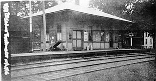
Sanford station was a passenger rail station on the Danbury and Norwalk Railroad and later the Danbury Branch of both the Housatonic Railroad and the New York, New Haven, and Hartford Railroad. The station was located on the border between Ridgefield and Redding, Connecticut, and was located on Topstone Road. Opened in 1852 as a flag stop and located in the Topstone section of Redding, Connecticut, the original station building was destroyed in 1891 by a speeding freight train. A new station building was erected the following year and would serve until the station's closure in 1938. The station was called so because of the numerous families named Sanford in the area surrounding the station.

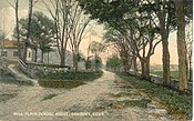
Mill Plain was a station on the main line of the New York and New England Railroad and later the Maybrook Line of the New York, New Haven, and Hartford Railroad. Opened in 1881, the station was originally located in the Mill Plain area in the western part of Danbury, Connecticut. The station was closed in 1928 and served multiple purposes from 1930 until 2018. The station building was restored and moved to the Danbury Railway Museum in 2019.

Lake Kenosia is a lake located in Danbury, Connecticut, United States. The lake covers 59.5 acres (24.1 ha).

Miry Brook is an unincorporated area in the City of Danbury in Fairfield County, Connecticut. It is located in the western part of the city, bordering Mill Plain to the north and west at Lake Kenosia and the town of Ridgefield, Connecticut, to the southwest. The Danbury Airport is located in Miry Brook.

Great Plain is an unincorporated area in the City of Danbury, Fairfield County, Connecticut. A former farming community, only remnants exist of this once thriving agricultural hub. It is located in the northeast section of the city, sharing a border with the Beaverbrook area of Danbury and Brookfield, CT.

Beaverbrook or Beaver Brook, is an unincorporated area in the City of Danbury, Fairfield County, Connecticut.