Gales Ferry, Connecticut

Last updated
Gales Ferry
Varsity House Gales Ferry.jpg
Yale's varsity crew quarters at the Ferry from the dock
New London County Connecticut Incorporated and Unincorporated areas Gales Ferry Highlighted 2010.svg
Coordinates: 41°25′48″N72°5′34″W / 41.43000°N 72.09278°W / 41.43000; -72.09278
CountryUnited States
State Connecticut
County New London
Town Ledyard
Area
  Total1.23 sq mi (3.18 km2)
  Land0.88 sq mi (2.27 km2)
  Water0.35 sq mi (0.91 km2)
Elevation
26 ft (8 m)
Population
 (2010)
  Total1,162
  Density940/sq mi (370/km2)
Time zone UTC−5 (Eastern (EST))
  Summer (DST) UTC−4 (EDT)
ZIP code
06335
Area code860
FIPS code09-30190
GNIS feature ID2631563 [1]

Gales Ferry is a village in the town of Ledyard, Connecticut, United States. It is located along the eastern bank of the Thames River. The village developed as a result of having a ferry to Uncasville located at this site, and from which the village was named. Gales Ferry was listed as a census-designated place for the 2010 Census, [2] with a population of 1,162. [3]

Contents

Much of the core of the original settlement at the site of the former ferry has been included in two separate historic districts, each with several farmstead buildings from the late colonial and early national periods (late 18th and early 19th century). The two historic districts are irregularly shaped, and are separated by a railroad cut and some non-contributing buildings.

Several farmsteads that are individually listed on the National Register of Historic Places are located close to Gales Ferry. These are the Nathan Lester House on Vinegar Hill Road, the Perkins-Bill House at 1040 Long Cove Road, and the Capt. Mark Stoddard Farmstead at 24 Vinegar Hill Road.

Village

An early-20th-century postcard of Gales Ferry's train station, which opened in 1899 when the Norwich and Worcester Railroad was extended to Groton Gales Ferry station postcard.jpg
An early-20th-century postcard of Gales Ferry's train station, which opened in 1899 when the Norwich and Worcester Railroad was extended to Groton

The village is named for the ferry operated by Roger Gale at the current site of a Yale University crew training camp. Gales Ferry is part of the town of Ledyard, with its own post office (ZIP code 06335) and the Gales Ferry branch of the Ledyard library. The community has several neighborhoods, including The Village, Birdland, Christy Hills, Sherwood Forest, Glenwoods, and Presidential Estates. Gales Ferry also has its own volunteer fire department and a small marina. Much of the economic activity in the town revolves around Naval Submarine Base New London just to the south in Groton.

The community has three schools: Juliet W. Long, which is Grades 3-6, the newer Gales Ferry school, which is K-2, and Ledyard Middle School, grade 7-8. They are located off the Thames River next door to each other. The former Gales Ferry School, located in Gales Ferry village, closed in 2001. In 2012, the town began using it as an incubator for local small businesses. [4]

According to the U.S. Census Bureau, Gales Ferry has a total area of 1.23 mi2 (3.18 km2), of which 0.88 mi2 (2.27 km2) is land and 0.35 mi2 (0.91 km2), or 28.7%, is water. [5]

The Ferry

The Yale Boathouse and Dock from the embankment above the old ferry landing Boathouse&Dock.jpg
The Yale Boathouse and Dock from the embankment above the old ferry landing

The ferry which gave its name to the surrounding community of Gales Ferry was first established on the Thames in 1740. John Comstock, Ralph Stoddard Jr. and John Hurlbut were the original three ferry men. It became known as Gale's Ferry when it was owned by Roger Gale from 1759 to 1764.

The ferry landing site at Gales Ferry ( 41°25′50.41″N72°5′36.06″W / 41.4306694°N 72.0933500°W / 41.4306694; -72.0933500 at 2 Riverside Place, is now occupied by a complex of buildings owned by Yale University which serve as a training camp for the Yale Heavyweight Men's Crew for the Harvard–Yale Regatta. The complex consists of the Varsity House, Manager's House and the Boathouse. The oldest structure on the site is the front portion of the varsity house which was originally constructed in the late eighteenth century as a private home and which has since been considerably expanded by multiple additions. The boathouse was designed by James Gamble Rogers, who was also responsible for much of the Gothic Revival architecture at Yale's New Haven campus.

Training quarters from a postcard, c. 1907-1915 PostcardGalesFerryCTYaleTrainingQuarters1907to1915.jpg
Training quarters from a postcard, c. 1907–1915

The boathouse adjoining the dock serves as a center of activity when the camp is occupied and provides storage and repair space for the boats. Freshman oarsmen are quartered in the second floor of the boathouse. Upperclassmen, including all of the rowers in the varsity and junior varsity boats, are quartered in the top floor of the varsity house. Women on the team, if there are any serving as coxswains, are housed either in the front wing of the varsity quarters or in the manager's house. The varsity house also contains several common spaces including a game room, a central common room and the dining room as well as bathrooms and the kitchen.

The ferry is of considerable historical interest since Yale's crew is the oldest college athletic team in America. The complex's buildings are filled with memorabilia and artifacts from the team's history. This is a living history, however, because of continuing use and occupation that bring the camp to life every year for the race. As the center of Yale Crew's institutional memory and the annual home of the longest-running rivalry in American college sports, the ferry serves as an important site in the history of sports.[ citation needed ]

Historic districts

Much of the core of the original settlement at the site of the former ferry has been included in two separate historic districts, each with several farmstead buildings from the late colonial and early national periods (late 18th and early 19th century). The two historic districts are irregularly shaped, and are separated by a railroad cut and some non-contributing buildings.

Gales Ferry Historic District No. 1
USA Connecticut location map.svg
Red pog.svg
Usa edcp location map.svg
Red pog.svg
LocationJct. of Hurlbutt Rd. and Riverside Pl., Ledyard Township, Gales Ferry, Connecticut
Coordinates 41°25′48″N72°5′34″W / 41.43000°N 72.09278°W / 41.43000; -72.09278 Coordinates: 41°25′48″N72°5′34″W / 41.43000°N 72.09278°W / 41.43000; -72.09278
Area13 acres (5.3 ha)
ArchitectGray, Stephen
Architectural styleGreek Revival, Italianate, Federal
MPS Ledyard MPS
NRHP reference No. 92001639 [6]
Added to NRHPDecember 14, 1992

Gales Ferry Historic District No. 1 is an irregularly shaped district in the area of the junction of Hurlbutt Road and Riverside Place. It includes work designed by Stephen Gray and examples of Greek Revival, Italianate, and Federal architecture. The district was listed on the National Register of Historic Places in 1992. In 1992, it included 31 contributing buildings over 13 acres. [6]

Significant buildings within the district include: [7]

Gales Ferry Historic District No. 2
LocationRoughly along Hurlbutt Rd., from Allyn Rd. to Military Hwy., Ledyard, Connecticut
Area25 acres (10 ha)
Architectural styleColonial, Federal, et al.
MPS Ledyard MPS
NRHP reference No. 02000865 [6]
Added to NRHPAugust 22, 2002

Gales Ferry Historic District No. 2 is another irregularly shaped historic district that runs roughly along Hurlbutt Road, from Allyn Road to Military Highway. The district was listed on the National Register of Historic Places in 2002. [6] It is an irregularly shaped area, with boundaries drawn to include historic Colonial, Federal and other architecture, and to exclude more modern intrusions. In 2002 it included 44 contributing buildings, 14 non-contributing buildings, two other contributing structures, and two contributing sites over 25 acres (100,000 m2). The Gales Ferry Cemetery is one of the contributing sites. [9]

Notable people

See also

Related Research Articles

<span class="mw-page-title-main">Ledyard, Connecticut</span> Town in Connecticut, United States

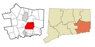
Ledyard is a Town in New London County, Connecticut, United States, located along the Thames River. The town is named after Colonel William Ledyard, a Revolutionary War officer who was killed at the Battle of Groton Heights. The population was 15,413 at the 2020 census. The Foxwoods Resort Casino, owned and operated by the Mashantucket Pequot Tribe, is located in the northeastern section of Ledyard, on the reservation owned by the tribe.

<span class="mw-page-title-main">Quaker Hill Historic District (Waterford, Connecticut)</span> Historic district in Connecticut, United States

The Quaker Hill Historic District encompasses the center a mainly residential village in northeastern Waterford, Connecticut. Running in a mostly linear fashion along Old Norwich Road between Connecticut Route 32 and Richard Grove Road, the area first grew as a settlement of religious non-conformists in the 17th century, developed in the 19th century as a small industrial village, and became more suburban in character in the 20th century. Its architecture is reflective of these changes, and it was listed on the National Register of Historic Places in 2002.

<span class="mw-page-title-main">Burnett's Corner, Connecticut</span> United States historic place

Burnetts Corner is a village in the town of Groton, Connecticut, and the site of Burnett's Corner Historic District, a historic district listed on the National Register of Historic Places.

<span class="mw-page-title-main">East Windsor Hill Historic District</span> Historic district in Connecticut, United States

East Windsor Hill Historic District is a historic district located in the northwestern corner of the town of South Windsor, Connecticut. It was listed on the National Register of Historic Places in 1986. The district runs along both sides of Main Street from the Scantic River south to the Edwards Cemetery. The district also includes areas west of Main Street to the Connecticut River, including properties along Ferry Lane. The district is located directly north of another historic district, Windsor Farms Historic District. The district encompasses a neighborhood of well-preserved largely folk vernacular buildings erected between about 1700 and 1860.

<span class="mw-page-title-main">Cannondale Historic District</span> Historic district in Connecticut, United States

Cannondale Historic District is a historic district in the Cannondale section in the north-central area of the town of Wilton, Connecticut. The district includes 58 contributing buildings, one other contributing structure, one contributing site, and 3 contributing objects, over a 202 acres (82 ha). About half of the buildings are along Danbury Road and most of the rest are close to the Cannondale train station .The district is significant because it embodies the distinctive architectural and cultural-landscape characteristics of a small commercial center as well as an agricultural community from the early national period through the early 20th century....The historic uses of the properties in the district include virtually the full array of human activity in this region—farming, residential, religious, educational, community groups, small-scale manufacturing, transportation, and even government. The close physical relationship among all these uses, as well as the informal character of the commercial enterprises before the rise of more aggressive techniques to attract consumers, capture some of the texture of life as lived by prior generations. The district is also significant for its collection of architecture and for its historic significance.

<span class="mw-page-title-main">Prospect Hill Historic District (New Haven, Connecticut)</span> Historic district in Connecticut, United States

The Prospect Hill Historic District is an irregularly-shaped 185-acre (75 ha) historic district in New Haven, Connecticut. The district encompasses most of the residential portion of the Prospect Hill neighborhood.

<span class="mw-page-title-main">Dwight Street Historic District</span> Historic district in Connecticut, United States

The Dwight Street Historic District is an irregularly shaped 135-acre (55 ha) historic district in New Haven, Connecticut. The district is located immediately west of the center of Downtown New Haven and is generally bounded by Elm Street on the north, Park Street on the east, North Frontage Road on the south, and Sherman Avenue on the west. It contains one of the city's highest concentrations of well-preserved 19th and early 20th-century residential architecture, much of which was developed for the working classes in the city's factories. It was listed on the National Register of Historic Places in 1983. The historic district includes most of the Dwight neighborhood and several blocks of the northeast corner of the West River neighborhood.

<span class="mw-page-title-main">Graniteville Historic District (Waterford, Connecticut)</span> Historic district in Connecticut, United States

The Graniteville Historic District is a mainly residential historic district in Waterford, Connecticut. It is ranged along Rope Ferry Road, near granite quarries that were once a major industry in the town. Most of the 31 historical buildings in the district are plain residences occupied by quarry workers; also included are the c. 1878 Graniteville School at 239 Rope Ferry Road, and the house of John Palmer, one of the proprietors of the quarries, at 218 Rope Ferry Road. His house, a c. 1860 Italianate updating of an older house, is the most elaborate house in the district. The district was listed on the National Register of Historic Places in 2003.

<span class="mw-page-title-main">Marion, Connecticut</span> United States historic place

Marion is a neighborhood in the town of Southington in Hartford County, Connecticut, United States. It is generally the area in the vicinity of the intersection of Route 322 and Marion Avenue just north of the Cheshire town line.

<span class="mw-page-title-main">Nathan Lester House</span> Historic house in Connecticut, United States

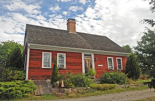
The Nathan Lester House is a historic house museum at 153 Vinegar Hill Road in the Gales Ferry section of Ledyard, Connecticut. Built in 1793, it is a well-preserved example of an unpretentious late 18th-century farmhouse, and one of the few houses of that age left in the town. It is located on over {{convert|156 acres of land, now owned by the town, which serves as a park and conservation land with trails.

<span class="mw-page-title-main">Capt. Mark Stoddard Farmstead</span> Historic house in Connecticut, United States

The Capt. Mark Stoddard Farmstead is a historic house at 24 Vinegar Hill Road in the Gales Ferry section of Ledyard, Connecticut. Built about 1770, it is a well-preserved example of a rural Cape style farmhouse, whose preservation includes its remote rural setting. The property was listed on the National Register of Historic Places in 1992.

<span class="mw-page-title-main">Main Sawmill</span> United States historic place

The Main Sawmill, now known as Ledyard Up-Down Sawmill, is a historic 19th-century sawmill at 175 Iron Street in Ledyard, Connecticut. The sawmill was built in 1869 by Israel Brown, and is the only known operational mill of this type in the state. It was listed on the National Register of Historic Places in 1972. It is now owned by the town and administered by the local historical society as a museum.

<span class="mw-page-title-main">Haviland and Elizabeth Streets–Hanford Place Historic District</span> Historic district in Connecticut, United States

The Haviland and Elizabeth Streets–Hanford Place Historic District is an irregularly shaped 4.3-acre (1.7 ha) historic district in Norwalk, Connecticut that was listed on the National Register of Historic Places in 1988. It encompasses a neighborhood that developed in the late 19th century following the introduction of railroad service to South Norwalk.

<span class="mw-page-title-main">Terry's Plain Historic District</span> Historic district in Connecticut, United States

The Terry's Plain Historic District is a 325-acre (132 ha) historic district in the town of Simsbury, Connecticut that was listed on the National Register of Historic Places in 1993. The district is significant as a preserved rural landscape. It included 27 contributing buildings of various architectural styles, including Greek Revival, Federal and Late Victorian architecture, and 17 non-contributing buildings.

<span class="mw-page-title-main">Spring Hill Historic District (Mansfield, Connecticut)</span> Historic district in Connecticut, United States

The Spring Hill Historic District encompasses a rural 19th-century village stretching along Storrs Road in Mansfield, Connecticut. Spring Hill developed as a rural waystation on an early 19th-century turnpike, and has seen only modest development since the late 19th century. The district was listed on the National Register of Historic Places in 1979.

<span class="mw-page-title-main">Shubel Smith House</span> Historic house in Connecticut, United States

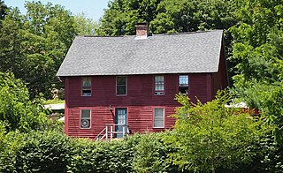
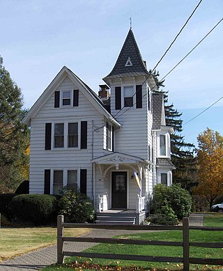
The Shubel Smith House, also known as Stonecroft, is a historic house at 515 Pumpkin Hill Road in Ledyard, Connecticut. It was built in 1807 as the estate of Shubel Smith, a sea captain, and is one of Ledyard's finest surviving farmhouses from that period. It was listed on the National Register of Historic Places in 1996. The listing included three contributing buildings on a 6.5-acre (2.6 ha) area, including the Georgian Colonial house and the "Yellow Barn" as well as a smaller outbuilding. Both of the large buildings have modernized interiors, serving as a bed and breakfast called Stonecroft Country Inn.

<span class="mw-page-title-main">Edward L. Burnham Farm</span> Historic house in Connecticut, United States

The Edward L. Burnham Farm is a historic farmstead at 580 Burnham Street West in Manchester, Connecticut. Built in 1861, the house is a well preserved example of a vernacular Greek Revival farmhouse. It was built for a locally prominent family that had farmed the surrounding land for generations. The house was listed on the National Register of Historic Places in 1982.

<span class="mw-page-title-main">David Chapman Farmstead</span> Historic house in Connecticut, United States

The David Chapman Farmstead is a historic house at 128 Stoddards Wharf Road in Ledyard, Connecticut. Built about 1744, it is a well-preserved example of a vernacular rural farmhouse of the period, built by a descendant of one of Ledyard's early settlers. It was listed on the National Register of Historic Places in 1992.

<span class="mw-page-title-main">Capt. Thomas Fanning Farmstead</span> Historic farmstead

The Capt. Thomas Fanning Farmstead is a historic farm property at 1004 Shewville Road in Ledyard, Connecticut. With a building history dating to about 1746, it is one of the oldest surviving agricultural properties in the town, including the house, barn, and smaller outbuildings. The property, now reduced to 4 acres (1.6 ha), was listed on the National Register of Historic Places in 1992.

<span class="mw-page-title-main">William Noyes Farmstead</span> Historic house in Connecticut, United States

The William Noyes Farmstead is a historic farm property at 340 Gallup Hill Road in Ledyard, Connecticut. Dating to about 1735, it is a well-preserved example of a rural farmstead. It was listed on the National Register of Historic Places in 1992.

References

  1. U.S. Geological Survey Geographic Names Information System: Gales Ferry
  2. U.S. Geological Survey Geographic Names Information System: Gales Ferry, Connecticut
  3. "Profile of General Population and Housing Characteristics: 2010 Demographic Profile Data (DP-1): Gales Ferry CDP, Connecticut". United States Census Bureau . Retrieved October 29, 2012.
  4. Boyle, Lindsay (September 12, 2015). "Former Gales Ferry School building thriving as town-owned business incubator". The New London Day.
  5. "US Gazetteer files: 2019". United States Census Bureau . Retrieved 2020-07-19.
  6. 1 2 3 4 "National Register Information System". National Register of Historic Places . National Park Service. March 13, 2009.
  7. Jan Cunningham (April 28, 1992). "National Register of Historic Places Registration: Gales Ferry Historic District No. 1". National Park Service. and https://npgallery.nps.gov/NRHP/GetAsset/NRHP/92001639_photos
  8. "Gales Ferry Historic District Number 1, Ledyard Township, New London County, Ledyard, CT, 06335".
  9. David F. Ransom (January 2002). "National Register of Historic Places Registration: Gales Ferry Historic District #2, Ledyard, CT". National Park Service. and Accompanying 15 photos, from 2001 (see captions on pages 14-15 of text document)