Stonington (borough), Connecticut

Last updated

Stonington
Borough of Stonington
Stonington light.png
StoningtonCTseal.gif
Etymology: Same name as the town it's located in
Nickname: 
The Borough
New London County Connecticut Incorporated and Unincorporated areas Stonington (Borough) Highlighted 2010.svg
Stonington (borough), Connecticut
Coordinates: 41°20′04″N71°54′21″W / 41.3344°N 71.9058°W / 41.3344; -71.9058
CountryFlag of the United States.svg  United States
stateFlag of Connecticut.svg  Connecticut
County New London
Region Southeastern CT
Town Stonington
Government
  Borough WardenJeffrey Callahan
Area
  Total2 km2 (0.7 sq mi)
  Land0.8 km2 (0.3 sq mi)
  Water0.8 km2 (0.3 sq mi)
Population
 (2020)
  Total976
  Density540/km2 (1,400/sq mi)
Time zone UTC-5 (Eastern (EST))
  Summer (DST) UTC-4 (EDT)
ZIP Code
06378
Area code 860
FIPS code 09-73700
GNIS feature ID2378292
Website stoningtonboroughct.com

Stonington is a borough and the town center of Stonington, Connecticut, referred to by locals as "The Borough". The population was 976 at the 2020 United States Census, up from 929 in 2010. [1]

Contents

The densely built Borough of Stonington occupies a point of land that projects into Little Narragansett Bay. It has two main streets that link Cannon Square and Wadawanuck Square, named for the former Wadawanuck Hotel that brought wealthy visitors in the post-Civil War era. Its colonial, Federal, and Greek revival architectures have been preserved through the lack of traffic or modern industry, together with the borough's role as a fashionable summer residence, while the activity of one of Connecticut's last remaining fishing and lobstering fleets keeps it from being simply a quaint, historic village. There is a large community of Portuguese descent.

History

On August 30, 1775, a ship's tender chased two small private sloops into Stonington Harbor during the American Revolutionary War. The sloops had made it to the dock and discharged their passengers when the tender fired a broadside into the dock and stores before sailing out of the harbor again. It returned later in the company of another tender and HMS Rose. All three ships then bombarded the town throughout the day. The local militia assembled and returned fire, claiming to have killed five or six men aboard the ships. [2]

A more damaging attack occurred between August 9 and 12, 1814 during the War of 1812. The British vessels HMS Ramillies, HMS Pactolus, HMS Dispatch, and HMS Terror appeared offshore on August 9, 1814 under the command of Sir Thomas Hardy. The British demanded immediate surrender, but Stonington's citizens replied with a note that stated, "We shall defend the place to the last extremity; should it be destroyed, we shall perish in its ruins." [3] The Royal Navy pounded the town for three days, but the only fatality was that of an elderly woman who was mortally ill. They sailed off on August 12 after suffering many dead and wounded.

The bombardiers with bomb and ball
Soon made a farmer's barrack fall,
And did a cow-house badly maul
That stood a mile from Stonington.
They kill'd a goose, they kill'd a hen
Three hogs they wounded in a pen—
They dashed away and pray what then?
This was not taking Stonington.
But some assert, on certain grounds,
(Beside the damage and the wounds),
It cost the king ten thousand pounds
To have a dash at Stonington.

The Stonington Harbor Light is a low stone building erected in 1840. In 1925, it became the flagship museum of the Stonington Historical Society, making it the oldest lighthouse museum in America. Throughout the 19th century, Stonington supported a small fishing, whaling, and sealing fleet, with some direct trade with the West Indies, enough in volume for it to be made a port of entry in 1842. The small granite Customs House faces Main Street just north of Cannon Square. Today, Stonington boasts the last commercial fishing fleet in Connecticut.

Geography

According to the United States Census Bureau, the borough has a total area of 0.7 square miles (1.8 km2), of which 0.3 square miles (0.9 km2) is land and 0.3 square miles (0.9 km2), or 50.72%, is water.

Demographics

Historical population
CensusPop.Note
1900 2,278
1910 2,083−8.6%
1920 2,1000.8%
1930 2,006−4.5%
1940 1,826−9.0%
1950 1,739−4.8%
1960 1,622−6.7%
1970 1,413−12.9%
1980 1,228−13.1%
1990 1,100−10.4%
2000 1,032−6.2%
2010 929−10.0%
2020 9765.1%
U.S. Decennial Census [4]

As of the census [5] of 2000, there were 1,032 people, 556 households, and 260 families residing in the borough. The population density was 3,071.2 inhabitants per square mile (1,185.8/km2). There were 723 housing units at an average density of 2,151.6 per square mile (830.7/km2). The racial makeup of the borough was 96.90% White, 0.58% Black or African American, 0.29% Native American, 0.29% Asian, 0.10% Pacific Islander, 0.29% from other races, and 1.55% from two or more races. Hispanic or Latino of any race were 0.97% of the population.

There were 556 households, out of which 13.5% had children under the age of 18 living with them, 37.1% were married couples living together, 8.3% had a female householder with no husband present, and 53.1% were non-families. 46.6% of all households were made up of individuals, and 16.5% had someone living alone who was 65 years of age or older. The average household size was 1.82 and the average family size was 2.54.

In the borough the population was spread out, with 12.8% under the age of 18, 4.3% from 18 to 24, 27.5% from 25 to 44, 33.1% from 45 to 64, and 22.3% who were 65 years of age or older. The median age was 48 years. For every 100 females, there were 86.3 males. For every 100 females age 18 and over, there were 85.6 males.

The median income for a household in the borough was $53,000, and the median income for a family was $78,324. Males had a median income of $43,472 versus $34,375 for females. The per capita income for the borough was $45,444. About 3.3% of families and 8.0% of the population were below the poverty line, including 9.0% of those under age 18 and 5.1% of those age 65 or over.

Related Research Articles

<span class="mw-page-title-main">Aleutians East Borough, Alaska</span> Borough in Alaska, United States

Aleutians East Borough is a 2nd class borough in the U.S. state of Alaska. As of the 2020 census the borough's population was 3,420. The borough seat is Sand Point.

<span class="mw-page-title-main">New London County, Connecticut</span> County in Connecticut, United States

New London County is in the southeastern corner of Connecticut and comprises the Norwich-New London, Connecticut Metropolitan Statistical Area, which is also included in the Hartford-East Hartford, Connecticut Combined Statistical Area. There is no county government and no county seat, as is the case with all eight of Connecticut's counties; towns are responsible for all local government activities, including fire and rescue, snow removal, and schools.

<span class="mw-page-title-main">Hancock County, Maine</span> County in Maine, United States

Hancock County is a county located in the U.S. state of Maine. As of the 2020 census, the population was 55,478. Its county seat is Ellsworth. The county was incorporated on June 25, 1789, and named for John Hancock, the first governor of the Commonwealth of Massachusetts.

<span class="mw-page-title-main">Sand Point, Alaska</span> City in Alaska, United States

Sand Point, also known as Popof Island, is a city in Aleutians East Borough, Alaska, United States. At the 2010 census the population was 976, up from 952 in 2000, but by the 2020 Census this had reduced to 578. It is on northwestern Popof Island, one of the Shumagin Islands, off the Alaska Peninsula. It is the borough seat of Aleutians East Borough, and is near the entrance to the Bering Sea.

<span class="mw-page-title-main">Bantam, Connecticut</span> Borough in Connecticut, United States

Bantam is a borough in Litchfield County, Connecticut, United States. The population was 720 at the 2020 census. It is part of the town of Litchfield.

<span class="mw-page-title-main">Griswold, Connecticut</span> Town in Connecticut, United States

Griswold is a town in New London County, Connecticut, United States. The town is part of the Southeastern Connecticut Planning Region. The population was 11,402 at the 2020 census. Griswold contains the borough of Jewett City and the villages of Doaneville, Kaalmanville, Rixtown, Glasgo, Hopeville, Nathanieltown, and Pachaug.

<span class="mw-page-title-main">Stonington, Illinois</span> Village in Illinois, United States

Stonington is a village in Christian County, Illinois, United States. The population was 837 at the 2020 census.

<span class="mw-page-title-main">Stonington, Maine</span> Town in the state of Maine, United States

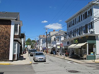
Stonington is a town in Hancock County, Maine, United States. It is located on the southern portion of the island of Deer Isle. The population was 1,056 at the 2020 census. It includes the villages of Burnt Cove, Oceanville, Green Head, and Clam City. A picturesque working waterfront and tranquil tourist destination in eastern Penobscot Bay, Stonington has consistently ranked among the top lobster ports in the country and is the largest lobster port in Maine. In 2011, 14,854,989 pounds of lobster were landed by Stonington fishermen, with a value of $46.3 million.

<span class="mw-page-title-main">Winter Harbor, Maine</span> Town in the state of Maine, United States

Winter Harbor is a town on the Schoodic Peninsula in Hancock County, Maine, United States. The population was 461 at the 2020 census. The town is located just outside the Schoodic Peninsula portion of Acadia National Park and is due east of the town of Bar Harbor and Ellsworth. Winter Harbor was once the location of a US Naval Station, NSGA-WH, which closed in the mid-2000s, and is now home to the Schoodic Institute’s Education and Research Center.

<span class="mw-page-title-main">Bay de Noc Township, Michigan</span> Civil township in Michigan, United States

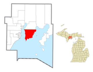
Bay de Noc Township is a civil township of Delta County in the U.S. state of Michigan. As of the 2010 census, the township population was 305, down from 329 at the 2000 census. The township covers the southern portion of the Stonington Peninsula separating Little Bay de Noc and Big Bay de Noc on Lake Michigan.

<span class="mw-page-title-main">Edwardsville, Pennsylvania</span> Borough in Pennsylvania, United States

Edwardsville is a borough in Luzerne County, Pennsylvania, United States. The population was 4,918 at the 2020 census.

<span class="mw-page-title-main">Orwigsburg, Pennsylvania</span> Borough in Pennsylvania, United States

Orwigsburg is a borough in Schuylkill County, Pennsylvania. The borough was named for its founder, Peter Orwig, and created from West Brunswick Township in 1823.

<span class="mw-page-title-main">Tidioute, Pennsylvania</span> Borough in Pennsylvania, United States

Tidioute is a borough in Warren County, Pennsylvania, United States. The population was 688 at the 2010 census.

<span class="mw-page-title-main">Omro (town), Wisconsin</span> Town in Wisconsin, United States

Omro is a town in Winnebago County, Wisconsin, United States. The population was 2,116 at the 2010 census. The City of Omro and the unincorporated communities of Harbor Springs, Reighmoor, Rivermoor, and Zion are located in the town.

<span class="mw-page-title-main">Stonington, Connecticut</span> Town in Connecticut, United States

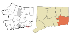
Stonington is a town located in New London County, Connecticut. The municipal limits of the town include the borough of Stonington, the villages of Pawcatuck, Lords Point, and Wequetequock, and the eastern halves of the villages of Mystic and Old Mystic. Stonington is part of the Southeastern Connecticut Planning Region. The population of the town was 18,335 at the 2020 census.

<span class="mw-page-title-main">Newtown (borough), Connecticut</span> Borough in Connecticut, United States

Newtown is a borough in Fairfield County, Connecticut, United States, within the town of Newtown. The population was 1,941 at the 2010 census.

<span class="mw-page-title-main">Clinton, Connecticut</span> Town in Connecticut, United States

Clinton is a town in Middlesex County, Connecticut, United States. The town is part of the Lower Connecticut River Valley Planning Region. The population of the town was 13,185 at the 2020 census. The town center along the shore line was listed as a census-designated place (CDP) by the U.S. Census Bureau in the 2020 census.

<span class="mw-page-title-main">Groton (city), Connecticut</span> City in Connecticut

The City of Groton is a dependent political subdivision of the town of Groton, Connecticut. The city was settled in 1655 as Groton Bank, and the area developed into the principal village of the town of Groton. The village of Groton incorporated as a borough in 1903, and the residents of the borough of Groton reincorporated as the city of Groton in 1964. It is the only remaining city in the state of Connecticut that is not governmentally consolidated with its parent town. The city is part of the Southeastern Connecticut Planning Region. The population was 10,389 at the 2010 census.

<span class="mw-page-title-main">Greenwich (CDP), Connecticut</span> Census-designated place in Connecticut, United States

Greenwich is a census-designated place (CDP) in Fairfield County, Connecticut, United States. It is one of several CDPs within the town of Greenwich and corresponds to the historic municipal center of the town and surrounding residential and commercial areas. As of the 2010 census, the population of the Greenwich CDP was 12,942, out of 61,171 in the entire town.

<span class="mw-page-title-main">Boothbay Harbor, Maine</span> Town in Maine, United States

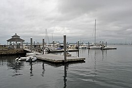
Boothbay Harbor is a town in Lincoln County, Maine, United States. The population was 2,027 at the 2020 census. It includes the neighborhoods of Bayville, Mount Pisgah, and Sprucewold, and the villages of Isle of Springs and West Boothbay Harbor. During summer months, the entire Boothbay Harbor region is a popular yachting and tourist destination.

References

  1. "Profile of General Population and Housing Characteristics: 2010 Demographic Profile Data (DP-1): Stonington borough, Connecticut". United States Census Bureau . Retrieved October 29, 2012.
  2. "Bombardment of Stonington Harbor". New York Gazette. September 11, 1775. Retrieved August 5, 2014.
  3. "Stonington: A Connecticut seafaring town has held off all challenges to its essential character for three centuries" . Retrieved July 4, 2014.
  4. "Census of Population and Housing". Census.gov. Retrieved June 4, 2015.
  5. "U.S. Census website". United States Census Bureau . Retrieved January 31, 2008.