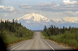
The Alaska Highway was constructed during World War II to connect the contiguous United States to Alaska across Canada. It begins at the junction with several Canadian highways in Dawson Creek, British Columbia, and runs to Delta Junction, Alaska, via Whitehorse, Yukon. When it was completed in 1942, it was about 2,700 kilometres (1,700 mi) long, but in 2012, it was only 2,232 km (1,387 mi). This is due to the continuing reconstruction of the highway, which has rerouted and straightened many sections. The highway opened to the public in 1948. Once legendary for being a rough, challenging drive, the highway is now paved over its entire length. Its component highways are British Columbia Highway 97, Yukon Highway 1, and Alaska Route 2.

U.S. Route 97 (US 97) is a major north–south route of the United States Numbered Highway System in the Pacific Northwest region. It runs for approximately 670 miles (1,078 km) through the states of California, Oregon, and Washington, primarily serving interior areas on the east side of the Cascade Mountains. The highway terminates to the south at a junction with Interstate 5 (I-5) in Weed, California, and to the north at the Canadian border near Osoyoos, British Columbia, where it becomes British Columbia Highway 97. Major cities on the US 97 corridor include Klamath Falls, Bend, and Redmond in Oregon; and Yakima, Ellensburg, and Wenatchee in Washington. A portion of the highway in California and Oregon is part of the Volcanic Legacy Scenic Byway.
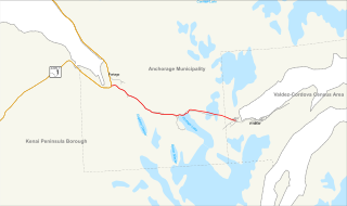
The Glenn Highway is a highway in the U.S. state of Alaska, extending 179 miles (288 km) from Anchorage near Merrill Field to Glennallen on the Richardson Highway. The Tok Cut-Off is often considered part of the Glenn Highway, for a total length of 328 miles (528 km).

The George Parks Highway, usually called simply the Parks Highway, runs 323 miles (520 km) from the Glenn Highway 35 miles (56 km) north of Anchorage to Fairbanks in the Alaska Interior. The highway, originally known as the Anchorage-Fairbanks Highway, was completed in 1971, and given its current name in 1975.

The Alaska Railroad is a Class II railroad that operates freight and passenger trains in the state of Alaska. The railroad's mainline runs between Seward on the southern coast and Fairbanks, near the center of the state. It passes through Anchorage and Denali National Park, to which 17% of visitors travel by train.

The Alaska Marine Highway (AMH) or the Alaska Marine Highway System (AMHS) is a ferry service operated by the U.S. state of Alaska. It has its headquarters in Ketchikan, Alaska.

The Sterling Highway is a 138-mile-long (222 km) state highway in the south-central region of the U.S. state of Alaska, leading from the Seward Highway at Tern Lake Junction, 90 miles (140 km) south of Anchorage, to Homer.
The Seward Highway is a highway in the U.S. state of Alaska that extends 125 miles (201 km) from Seward to Anchorage. It was completed in 1951 and runs through the scenic Kenai Peninsula, Chugach National Forest, Turnagain Arm, and Kenai Mountains. The Seward Highway is numbered Alaska Route 9 (AK-9) for the first 37 miles (60 km) from Seward to the Sterling Highway and AK-1 for the remaining distance to Anchorage. At the junction with the Sterling Highway, AK-1 turns west towards Sterling and Homer. About eight miles (13 km) of the Seward Highway leading into Anchorage is built to freeway standards. In Anchorage, the Seward Highway terminates at an intersection with 5th Avenue, which AK-1 is routed to, and which then leads to the Glenn Highway freeway.
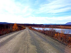
The Steese Highway is a highway in the Interior region of the U.S. state of Alaska that extends 161 miles (259 km) from Fairbanks to Circle, a town on the Yukon River about 50 miles (80 km) south of the Arctic Circle. The highway was completed in 1927 and is named for U.S. Army General James G. Steese, a former president of the Alaska Road Commission. It is paved for about the first 81 miles (130 km) and around the town of Central it turns to dirt and gravel. Much of it is narrow and winding.
This article discusses transportation in the U.S. state of Alaska.

MV Lituya is a shuttle ferry operated by the Alaska Marine Highway System. Her route connects Metlakatla on Annette Island to Ketchikan.
The United States Bicycle Route System is the national cycling route network of the United States. It consists of interstate long-distance cycling routes that use multiple types of bicycling infrastructure, including off-road paths, bicycle lanes, and low-traffic roads. As with the complementary United States Numbered Highways system for motorists, each U.S. Bicycle Route is maintained by state and local governments. The USBRS is intended to eventually traverse the entire country, like the Dutch National Cycle Routes and the United Kingdom's National Cycle Network, yet at a scale similar to the EuroVelo network that spans Europe.

Route 49 is a Connecticut state highway from Route 2 in Stonington to Route 14A in Sterling, in the southeast part of the state. It is a scenic route that runs 21.74 miles (34.99 km) through the Pachaug State Forest.
Alaska Route 1 (AK-1) is a state highway in the southern part of the U.S. state of Alaska. It runs from Homer northeast and east to Tok by way of Anchorage. It is one of two routes in Alaska to contain significant portions of freeway: the Seward Highway in south Anchorage and the Glenn Highway between Anchorage and Palmer.

Exit numbers in the United States are assigned to freeway junctions, and are usually numbered as exits from freeways. Exit numbers generally are found above the destinations and route number(s) at the exit, as well as a sign in the gore. Exit numbers typically reset at political borders such as state lines. Some major streets also use exit numbers. Freeway exits in the United States are usually numbered in two formats: distance-based and sequential.

Interstate 795 (I-795) is a 25.49-mile (41.02 km) auxiliary Interstate Highway in the US state of North Carolina. It connects the city of Goldsboro to I-95 just south of Wilson, paralleling the northern portion of US Route 117 (US 117). The road runs a five-mile (8.0 km) concurrency with US 264 and I-587 in the last section of the route. It serves as a primary freeway spur for the city of Goldsboro to the Interstate Highway System, as well part of a major cargo route for the cities of Down East, which was a part of the impetus for its designation in 2007.

The Alaska Department of Transportation & Public Facilities (DOT&PF) is a department within the government of Alaska. Its headquarters are in Alaska's capital city, Juneau. The mission of Alaska DOT&PF is to "Keep Alaska Moving through service and infrastructure."The Alaska Department of Transportation was established on July 1, 1977, by Alaska Highway Commissioner Walter Parker during the administration of Governor Jay Hammond. The Alaska Department of Transportation and Public Facilities merged the former departments of Highways and Public Works.

The following outline is provided as an overview of and topical guide to the U.S. state of Alaska:
The Portage Glacier Highway, or Portage Glacier Road, is a highway located in the U.S. state of Alaska. The highway is made up of a series of roads, bridges, and tunnels that connect the Portage Glacier area of the Chugach National Forest and the city of Whittier to the Seward Highway. Most of the highway travels through mainly rural areas just north of the Kenai Peninsula, with the Anton Anderson Memorial Tunnel passing under Maynard Mountain, part of the Chugach Mountain Range. Parts of the route were first constructed in the early 1900s, and the entire highway was completed on June 7, 2000, as part of the Whittier Access Project. The main portion of the highway traveling from the western terminus to the Begich, Boggs Visitor Center at Portage Lake is designated as National Forest Highway 35 by the United States Forest Service (USFS).