List of state highways in Vermont

Last updated

I-91.svg US 7.svg Vermont 9.svg Vermont 8A (town).svg
Standard markers for Interstates, US highways, state-maintained and locally maintained state highways in Vermont.
Highway names
Interstates Interstate X (I-X)
US Highways U.S. Route X (US X)
State Vermont Route X (VT Route X, VT X)
System links

The following is a list of state highways in Vermont as designated by the Vermont Agency of Transportation (VTrans). The classification of these state highways fall under three primary categories: Interstate Highways, U.S. Highways, and Vermont routes. Routes in Vermont are abbreviated as "VT #" by VTrans and also abbreviated as "VT Route #" and "Route #" in common usage. A small number of minor state highways, typically bypassing old alignments or short connector routes, are instead assigned names and unsigned four-digit numbers beginning with 9. Most state highways are maintained by VTrans; however, portions of some routes and some entire routes are maintained by local governments, such as towns or cities, instead. These town-maintained routes are internally called "state-designated town highways" and are typically designated as "class 1 town highways". Many of Vermont's state-numbered highways retain their numbers from when they were part of the New England road marking system of the 1920s; for instance, VT 9 was part of Route 9 of the New England system.

Contents

Prior to 1995, Vermont used the standard circular highway shield to sign all of its routes, which had black numerals on a white circle over a black background. In 1995, Vermont introduced a new shield for state-maintained highways—a green shield with the word "Vermont" at the top. The circular highway shield continues to be used for locally maintained routes. [1] Some state-maintained routes are still signed with the circular highway shield, but they are being converted to the newer Vermont shield as signs are replaced. Recent guide sign replacement projects along Vermont's Interstate Highways include the newer green shields to indicate Vermont state routes, as the older guide signs used the circular shield.

According to Vermont's 2012 Fact Book [2] the state spent $547 million in 2011. Less than half ($206 million) on preservation and maintenance. 28% of the roads remain in "very poor" condition. The book estimates $100 million would be required to reduce that to 25%. [3] The VTrans report to the legislature in 2012 appeared to disagree, stating that the goal of 25% in poor condition had been met. [3] The Burlington Free Press conducted a survey on 11% of the roads and found that signage was inadequate, often not warning drivers of dangerous curves; striping was inadequate, having been scraped off by winter snowplowing. Therefore, sides of the road could not be seen at night. Speed limit signs were placed near villages but nowhere else; guardrails were unpredictably placed. A spokesperson for VTrans agreed, citing fiscal restraints. [3] Troopers investigating accidents are not required to record road conditions which may have contributed to an accident. [3]

Vermont Route 191 ends in Newport. END! VT 191.jpg
Vermont Route 191 ends in Newport.

Interstate Highways

NumberLength (mi) [4] Length (km)Southern or western terminusNorthern or eastern terminusFormedRemovedNotes
I-89.svg I-89 130.254209.623 I-89 at the New Hampshire state line in Hartford Route 133 at the Canadian border in Highgate 01958-01-011958current Route 133 will be upgraded to a freeway and become A-35, expected completion in 2023 [5]
I-91.svg I-91 177.432285.549 I-91 at the Massachusetts state line in Guilford A-55 at the Canadian border at Derby Line 01958-01-011958current
I-93.svg I-93 11.10417.870 I-93 at the New Hampshire state line in Waterford I-91 in Waterford 01982-01-011982current
I-189.svg I-189 1.4882.395 US 7 in South Burlington I-89 in South Burlington 01962-01-011962current
I-289.svg I-289 15.1024.30 Colchester Williston 01982-01-01198201986-01-011986Partially built as VT 289
  •       Former

U.S. Highways

Mainline routes

NumberLength (mi) [6] Length (km)Southern or western terminusNorthern or eastern terminusFormedRemovedNotes
US 2.svg US 2 150.518242.235 US 2 at the New York state line in Alburgh US 2 at the New Hampshire state line in Guildhall 01926-01-011926current
US 4.svg US 4 66.059106.312 US 4 at the New York state line in Fair Haven US 4 at the New Hampshire state line in Hartford 01926-01-011926currentMostly follows the old New England Route 13 in Vermont
US 5.svg US 5 192.317309.504 US 5 at the Massachusetts state line in Guilford QC 143 at the Canadian border at Derby Line 01926-01-011926currentMostly follows the old New England Route 2; functionally bypassed by I-91
US 7.svg US 7 176.328283.772 US 7 at the Massachusetts state line in Pownal I-89 in Highgate 01926-01-011926currentMostly follows the old New England Route 4
US 302.svg US 302 35.74657.528 US 2 in Montpelier US 302 at the New Hampshire state line in Wells River 01935-01-011935current

Special routes

NumberLength (mi) [6] Length (km)Southern or western terminusNorthern or eastern terminusFormedRemovedNotes
Business plate.svg
US 2.svg US 2 Bus.
0.8871.427 US 2 in Montpelier US 2 / VT 12 in Montpelier Business route in Montpelier
Business plate.svg
US 4.svg US 4 Bus.
4.3717.034 US 4 in West Rutland US 4 / US 7 in city of Rutland Business route through Rutland
Alternate plate.svg
US 5.svg US 5 Alt.
1.2822.063 US 5 in St. Johnsbury US 5 in St. Johnsbury Alternate route in St. Johnsbury
Alternate plate.svg
US 5.svg US 5 Alt.
0.6040.972 US 5 in Derby Line I-91 in Derby Line Alternate route in Derby Line
Alternate plate.svg
US 5.svg US 5 Alt.
1.2832.065 US 5 in city of Newport US 5 in city of Newport Alternate route in Newport
Alternate plate.svg
US 7.svg US 7 Alt.
2.1073.391 US 7 in Burlington US 2 / US 7 in Burlington Alternate route in Burlington

Vermont routes

All routes in Vermont are designated by the Vermont Agency of Transportation (VTrans). Most are also owned and maintained by VTrans, but some are partially or wholly owned and maintained by the towns it passes through instead. Routes maintained by VTrans are classified by the agency as "state-maintained highways" and signed using Vermont's green route shields. Routes maintained by the town are classified as "town-maintained routes" and signed using the national circular highway shield.

Five routes in the system have both state- and town-maintained sections. Although maintenance along these routes varies by area, VTrans considers state and town-maintained highways that bear the same signed number as one continuous route.

Designations shaded in gray are no longer active.

Numbered state highways

NumberLength (mi) [7] [8] Length (km)Southern or western terminusNorthern or eastern terminusFormedRemovedNotes
Vermont 2A.svg VT 2A 13.85322.294 VT 116 in St. George US 2 / US 7 in Colchester  
Vermont 2B.svg VT 2B 3.4595.567 US 2 in Danville US 2 in St. Johnsbury  
Vermont 3.svg VT 3 7.82812.598 US 4 Business in Rutland US 7 in Pittsford  
Vermont 4A.svg VT 4A 14.17422.811 US 4 in Fair Haven US 4 Business in West Rutland  
Vermont 5A.svg VT 5A 19.49831.379 US 5 in Burke VT 105 in Charleston Mostly follows the old New England Route 2A
Vermont 7A.svg VT 7A 27.82044.772 US 7 in Bennington US 7 in Dorset Follows an old segment of US 7
Vermont 7B.svg VT 7B 6.78610.921 US 7 in Wallingford US 7 in Clarendon  
Vermont 8.svg VT 8 13.15521.171 MA 8 at the Massachusetts state line in Readsboro VT 9 in Searsburg Mostly follows the old New England Route 8
Vermont 8A (town).svg VT 8A 3.3005.311 MA 8A at the Massachusetts state line in Whitingham VT 112 in Whitingham Entirely town maintained
Vermont 9.svg VT 9 46.95975.573 NY 7 at the New York line in Bennington NH 9 at the New Hampshire state line in Brattleboro Mostly follows the old New England Route 9
Vermont 10.svg VT 10 4.3737.038 VT 103 in Chester VT 106 in Springfield  
Vermont 10A.svg VT 10A 0.5220.840 I-91 / US 5 in Norwich NH 10A at the New Hampshire state line in Norwich spur route of New Hampshire Route 10; unrelated to Vermont Route 10
Vermont 11.svg VT 11 42.15467.840 VT 7A in Manchester NH 11 at the New Hampshire state line in Springfield Mostly follows the old New England Route 11
Vermont 12.svg VT 12 101.627163.553 NH 12 at the New Hampshire state line in Weathersfield VT 15A / VT 100 in Morrisville  
Vermont 12A.svg VT 12A 20.84233.542 VT 12 in Randolph VT 12 in Northfield  
Vermont 14.svg VT 14 108.946175.332 US 4 / US 5 in Hartford VT 100 in Newport  
Vermont 15.svg VT 15 68.957110.976 US 2 / US 7 in Winooski US 2 in Danville  
Vermont 15A.svg VT 15A 1.8242.935 VT 12 / VT 100 in Morrisville VT 15 in Morrisville  
Vermont 16.svgEllipse sign 16.svg VT 16 27.89044.885 VT 15 in Hardwick VT 5A in Westmore 01960-01-011960 [9] currentPartially town maintained
Vermont 17.svg VT 17 40.40965.032 NY 185 at the New York state line in Addison VT 100 in Waitsfield  
Vermont 18.svg VT 18 7.88712.693 NH 18 at the New Hampshire state line in Waterford US 2 in St. Johnsbury  
Ellipse sign 19.svg VT 19 VT 30A in Bridport VT 30 in Middlebury 01935-01-01193501953-01-011953 
Vermont 22A.svg VT 22A 44.73871.999 NY 22A at the New York state line in Fair Haven US 7 in Ferrisburgh spur route of New York Route 22
Ellipse sign 23.svg VT 23 7.37011.861 VT 125 in Middlebury VT 17 in Weybridge Entirely town maintained
Vermont 25.svg VT 25 17.73928.548 NH 25 at the New Hampshire state line in Bradford US 302 in Orange  
Vermont 25A.svg VT 25A 0.0880.142 US 5 in Fairlee NH 25A at the New Hampshire state line in Fairlee  
Vermont 25B.svg VT 25B 0.9811.579 VT 25 in Bradford US 5 in Bradford  
Vermont 26.svg VT 26 0.0130.021 VT 102 in Lemington NH 26 at the New Hampshire state line in Lemington  
Vermont 30.svg VT 30 111.870180.037 US 5 / VT 9 in Brattleboro US 7 in Middlebury  
VT 30A US 4 / VT 30 in Fair Haven US 7 in Vergennes 01935-01-01193501945-01-011945 
VT 30B NY 149 at the New York state line in Pawlet VT 30 in Pawlet 01935-01-01193501966-01-011966 [10]  
Vermont 31.svg VT 31 5.5358.908 Washington CR 25 at the New York state line in Wells VT 30 in Poultney 01966-01-011966 [10] current 
Ellipse sign 35.svg VT 35 21.22034.150 VT 30 in Townshend VT 11 in Chester Entirely town maintained
Vermont 36.svgEllipse sign 36.svg VT 36 29.43147.365 VT 78 in Swanton VT 108 in Bakersfield Partially town maintained
Vermont 38.svg VT 38 3.8646.219 US 7 in city of St. Albans Northwest State Correctional Facility in town of St. Albans  
Vermont 44.svgEllipse sign 44.svg VT 44 10.19016.399 VT 106 in Reading US 5 in Windsor Partially town maintained
Vermont 44A.svg VT 44A 2.9944.818 US 5 in Weathersfield VT 44 in Windsor  
Ellipse sign 53.svg VT 53 9.31014.983 VT 73 in Brandon US 7 in Salisbury Entirely town maintained
Ellipse sign 56.svg VT 56 US 5 in Barton VT 5A in Westmore 01955-01-01195501986-01-011986 
Vermont 58.svgEllipse sign 58.svg VT 58 30.90849.742 VT 118 in Montgomery VT 5A in Brownington Partially town maintained
Vermont 62.svg VT 62 4.5197.273 I-89 in Berlin US 302 in Barre  
Vermont 63.svg VT 63 3.9016.278 I-89 in Berlin VT 14 in Barre  
Vermont 64.svg VT 64 6.77010.895 VT 12 in Northfield VT 14 in Williamstown  
Vermont 65.svg VT 65 5.2228.404 VT 12 in Brookfield VT 14 in Brookfield  
Vermont 66.svg VT 66 7.62112.265 VT 12 in Randolph VT 14 in Randolph  
Vermont 67.svg VT 67 4.2546.846 NY 67 at the New York state line in Shaftsbury VT 7A in Shaftsbury  
Vermont 67A.svg VT 67A 3.3485.388 VT 7A in Bennington VT 67 in Bennington  
Ellipse sign 68.svg VT 68 US 2 in Alburgh QC 104 at the Canadian border in Alburgh 01955-01-01195501985-01-011985 
Vermont 73.svgEllipse sign 73.svg VT 73 36.67459.021 VT 74 in Shoreham VT 100 in Rochester Partially town maintained
Vermont 74.svg VT 74 13.26321.345 Fort Ticonderoga–Larrabees Point Ferry in Shoreham VT 30 in Cornwall  
Vermont 78.svg VT 78 21.12633.999 US 2 in Alburgh VT 105 in Sheldon  
Vermont 100.svg VT 100 216.666348.690 MA 8 at the Massachusetts state line in Stamford VT 105 in Newport  
Vermont 100A.svg VT 100A 6.97111.219 VT 100 in Plymouth US 4 in Bridgewater  
Vermont 100B.svg VT 100B 7.92212.749 VT 100 in Moretown US 2 in Middlesex  
Vermont 100C.svg VT 100C 4.5957.395 VT 15 in Johnson VT 100 in Hyde Park  
Vermont 101.svg VT 101 4.3336.973 VT 100 in Troy VT 105 in Troy  
Vermont 102.svg VT 102 43.75570.417 US 2 in Guildhall VT 114 / VT 253 in Canaan  
Vermont 103.svg VT 103 42.03667.650 US 5 in Rockingham US 7 in Clarendon  
Vermont 103A.svg VT 103A US 7 in Wallingford VT 103 in Mount Holly 01948-01-01194801960-01-011960 
Vermont 104.svg VT 104 20.50332.996 VT 15 in Cambridge VT 105 in St. Albans  
Vermont 104A.svg VT 104A 4.5277.286 US 7 in Georgia VT 104 in Fairfax  
Vermont 104B (1955).svg VT 104B US 7 / VT 104 in Swanton VT 105 in Sheldon 01935-01-01193501958-01-011958 
Vermont 105.svg VT 105 98.135157.933 US 7 in St. Albans Bridge Street at the New Hampshire state line in Bloomfield  
Vermont 105A.svg VT 105A 1.7992.895 VT 105 in Richford Chemin de la Vallée-Missisquoi at the Canadian border in Richford  
Vermont 106.svg VT 106 25.96341.783 VT 11 in Springfield US 4 in Woodstock  
Vermont 107.svg VT 107 13.50321.731 VT 100 in Stockbridge VT 14 in Royalton  
Vermont 108.svg VT 108 45.45073.145 VT 100 in Stowe QC 237 at the Canadian border in Berkshire  
Vermont 109.svg VT 109 14.80023.818 VT 108 in Cambridge VT 118 in Belvidere  
Vermont 110.svg VT 110 27.13643.671 VT 14 in Royalton US 302 in Barre  
Vermont 111.svg VT 111 15.13724.361 VT 105 in Derby VT 114 in Brighton  
Ellipse sign 112.svg VT 112 US 7 in Pownal NY 346 at the New York state line in Pownal 01926-01-01192601939-01-01c.1939renumbered VT 346 to match New York counterpart
Vermont 112.svg VT 112 7.45011.990 MA 112 at the Massachusetts state line in Halifax VT 100 in Whitingham 01947-01-011947current 
Vermont 113.svg VT 113 22.84736.769 VT 110 in Chelsea East Thetford Road at the New Hampshire state line in Thetford  
Vermont 113A.svg VT 113A VT 113 in Thetford East Thetford Road at the New Hampshire state line in Thetford 01935-01-01193501975-01-011975 
Vermont 114.svg VT 114 53.09485.447 US 5 / VT 122 in Lyndon Main Street at the New Hampshire state line in Canaan  
Ellipse sign 115.svg VT 115 US 7 in Brandon VT 100 in Rochester 01938-01-01193801967-01-011967 
Vermont 116.svg VT 116 40.75965.595 US 7 in Middlebury US 2 in South Burlington  
Vermont 116A.svg VT 116A VT 116 in St. George US 2 in Williston 01948-01-01194801973-01-011973 
Vermont 117.svgEllipse sign 117.svg VT 117 8.07212.991 VT 2A / VT 15 in Essex Junction US 2 in Richmond Partially town maintained
Vermont 118.svgEllipse sign 118.svg VT 118 28.54945.945 VT 100 in Eden VT 108 in Berkshire Partially town maintained
Vermont 119.svg VT 119 0.0800.129 US 5 / VT 142 in Brattleboro NH 119 at the New Hampshire state line in Brattleboro  
Vermont 120.svg VT 120 10.55416.985 VT 105 in Sheldon VT 108 in Berkshire  
Ellipse sign 121.svg VT 121 21.43934.503 VT 11 in Londonderry US 5 in Bellows Falls Entirely town maintained
Vermont 122.svg VT 122 15.21524.486 US 5 / VT 114 in Lyndon VT 16 in Glover  
Vermont 123.svg VT 123 0.3130.504 US 5 in Westminster NH 123 at the New Hampshire state line in Westminster  
Vermont 125.svg VT 125 35.90157.777 VT 17 in Addison VT 100 in Hancock  
Vermont 127.svgEllipse sign 127.svg VT 127 9.94015.997Pearl Street in Burlington US 2 / US 7 in Colchester Main section, which is entirely town maintained; 0.142-mile-long (0.229 km) other section is state maintained
Vermont 128.svg VT 128 11.61618.694 VT 15 in Essex VT 104 in Fairfax  
Vermont 129.svgEllipse sign 129.svg VT 129 5.4158.715School Street / Church Street in Isle La Motte US 2 in Alburgh Partially town maintained
Ellipse sign 130.svg VT 130 MA 112 at the Massachusetts state line in Halifax VT 8 in Whitingham 01935-01-01193501947-01-011947 
Vermont 131.svg VT 131 16.29926.231 VT 103 in Cavendish US 5 in Weathersfield  
Vermont 132.svgEllipse sign 132.svg VT 132 16.87727.161 VT 14 in Sharon US 5 in Norwich Partially town maintained
Vermont 133.svg VT 133 22.47636.172 VT 30 in Pawlet VT 4A in West Rutland 01960-01-011960 [9] current 
Ellipse sign 139.svg VT 139 1.8222.932 VT 105 in Richford QC 139 at the Canadian border in Richford Entirely town maintained
Vermont 140.svgEllipse sign 140.svg VT 140 25.05940.329 VT 30 in Poultney VT 103 in Mount Holly Partially town maintained
Vermont 141.svg VT 141 0.4930.793 VT 114 in Canaan QC 141 at the Canadian border in Canaan 01960-01-011960 [9] current 
Vermont 142.svg VT 142 10.84717.457 MA 142 at the Massachusetts state line in Vernon US 5 / VT 119 in Brattleboro  
Ellipse sign 143.svg VT 143 5.7509.254 VT 11 in Springfield US 5 in Springfield 01961-01-011961 [11] currentEntirely town maintained
Ellipse sign 144.svg VT 144 6.91011.121 VT 22A in Benson VT 30 in Sudbury Entirely town maintained
Vermont 147.svg VT 147 0.1450.233 VT 114 in Norton QC 147 at the Canadian border in Norton  
Vermont 149.svg VT 149 1.3022.095 NY 149 at the New York state line in Pawlet VT 30 in Pawlet 01966-01-011966 [10] current 
Ellipse sign 153.svg VT 153 13.14021.147 Washington CR 153 at the New York state line in Rupert VT 30 in Pawlet 01961-01-011961 [11] currentEntirely town maintained
Vermont 155.svg VT 155 10.37716.700 VT 100 in Weston VT 103 in Wallingford 01961-01-011961 [11] current 
Vermont 191.svg VT 191 2.2903.685 I-91 in Derby US 5 / VT 105 in Newport  
Vermont 207.svgEllipse sign 207.svg VT 207 13.82122.243 US 7 in St. Albans VT 235 in Franklin Partially town maintained
Vermont 214.svg VT 214 2.0613.317 US 2 in Plainfield VT 14 in East Montpelier  
Ellipse sign 215.svg VT 215 9.16014.742 US 2 in Marshfield VT 15 in Walden Entirely town maintained
Ellipse sign 225.svg VT 225 1.5902.559 US 2 in Alburgh QC 225 at the Canadian border in Alburgh Entirely town maintained
Vermont 232.svg VT 232 13.54821.803 US 302 in Groton US 2 in Marshfield  
Ellipse sign 235.svg VT 235 4.6407.467 VT 120 in Franklin QC 235 at the Canadian border in Franklin Entirely town maintained
Vermont 236.svg VT 236 6.1699.928 VT 105 in Sheldon VT 120 in Franklin  
Vermont 242.svg VT 242 12.87820.725 VT 118 in Montgomery VT 101 in Troy  
Vermont 243.svg VT 243 1.1811.901 QC 243 at the Canadian border in North Troy VT 105 in North Troy  
Vermont 244.svg VT 244 5.6409.077 VT 113 in Thetford US 5 in Fairlee  
Vermont 253.svg VT 253 2.1593.475 VT 102 / VT 114 in Canaan QC 253 at the Canadian border in Canaan  
Vermont 279.svg VT 279 6.0549.743 NY 915G at the New York state line in Bennington VT 9 in Bennington 02004-01-012004current 
Vermont 289.svg VT 289 3.9406.341 VT 2A in Essex VT 117 in Essex  
Vermont 313.svg VT 313 10.05016.174 NY 313 at the New York state line in Arlington US 7 in Sunderland  
Vermont 314.svg VT 314 5.4938.840 US 2 in South Hero US 2 in Grand Isle 01964-01-011964 [12] current 
Ellipse sign 315.svg VT 315 5.8309.382 VT 153 in Rupert VT 30 in Rupert Entirely town maintained
Vermont 346.svg VT 346 4.6287.448 US 7 in Pownal NY 346 at the New York state line in Pownal 01939-01-01c.1939current 
  •       Former

Ferry roads

NumberLength (mi)Length (km)Southern or western terminusNorthern or eastern terminusFormedRemovedNotes
Vermont F-1.svg VT F-1
Vermont F-2.svg VT F-2 01935-01-01c.193501942-01-01c.1942
Vermont F-3.svg VT F-3 01935-01-01c.193501964-01-011964 [12] Replaced by VT 314
Vermont F-4.svg VT F-4
Vermont F5.svg VT F-5 2.8904.651Charlotte–Essex ferry in Charlotte US 7 in Charlotte01928-01-01c.192802009-01-01c.2009Now CR 3
Vermont F-6.svg VT F-6 01930-01-01c.193001935-01-01c.1935
Vermont F-7.svg VT F-7 01927-01-01c.192701930-01-01c.1930Replaced by VT 17
Vermont F-8.svg VT F-8 01926-01-01c.192601935-01-01c.1935
Vermont F-9.svg VT F-9 01927-01-01c.192701954-01-011954 [13]
Vermont F-9A.svg VT F-9A 01930-01-01c.193001954-01-011954 [13]
Vermont F-10.svg VT F-10 01930-01-01c.193001954-01-011954 [13]
Vermont F-10A.svg VT F-10A 01930-01-01c.193001931-01-011931
  •       Former

Named state highways

These roads are maintained by the state but are not assigned signed route numbers. [14] The majority of them are minor connectors between two signed routes, making them similar to New York's reference routes. Unless a town is indicated in the southern or western terminus column, each highway is entirely within the town listed in the northern or eastern Terminus column.

NumberLength (mi) [15] Length (km)Southern or western terminusNorthern or eastern terminusLocal namesFormedRemovedNotes
VT 90200.8061.297West Barnet Road US 5 in Barnet Barnet State Highway I-91 exit 18
VT 90250.2360.380 VT 7A US 7 in Bennington Bennington North State Highway US 7 exit 2
VT 90302.4143.885 Edward F. Knapp State Airport US 302 in Berlin Berlin State HighwayIncludes Airport Road, 0.134-mile-long (0.216 km) concurrency with VT 62, and ramps from VT 62 to US 302
VT 90900.1350.217 I-91 US 5  / VT 9 in Brattleboro Brattleboro State Highway I-91 exit 3
VT 91500.3980.641 VT 4A East Hubbardton Road in Castleton Castleton State Highway US 4 exit 5
VT 91600.9141.471 Rutland–Southern Vermont Regional Airport VT 103 in Clarendon Clarendon State HighwayAirport Road
VT 91802.6304.233 Newport State Airport in Coventry US 5 in Newport Coventry State HighwayAirport Road
VT 92100.5980.962 VT 4A Scotch Hill Road in Fair Haven Fair Haven State Highway US 4 exit 3
VT 92400.1970.317 US 5 Lake Morey Road in Fairlee Fairlee State Highway I-91 exit 15
VT 92700.7991.286 VT 22A in Vergennes US 7 in Ferrisburgh Ferrisburgh State HighwayGreen Street and New Haven Road
VT 93300.6020.969 VT 102 Maidstone Bridge at Connecticut River in Maidstone Maidstone State HighwayLamoreaux Road; leads to US 3 in Stratford, NH
VT 93600.1700.274 US 2 Center Road in Middlesex Middlesex State Highway I-89 exit 9
VT 93900.8901.432 I-89 US 2 in Montpelier Montpelier State Highway I-89 exit 8; Memorial Drive
VT 94200.7571.218Montpelier State Highway in Montpelier Dog River Road at MontpelierBerlin town lineMontpelier Junction State HighwayIntersects Montpelier Junction Road, which leads to Montpelier Amtrak station
VT 94300.4820.776 US 5 Newbury Crossing at Connecticut River in Newbury Newbury State HighwayNewbury Crossing Road; leads to NH 10 in Haverhill, NH
VT 94800.5730.922 VT 114 VT 114 in Norton Norton State HighwayLake View Road; loop between two intersections with VT 114
VT 95401.1501.851 VT 10A US 5 in Norwich Norwich State HighwayRiver Road
VT 96000.2890.465Putney Landing Road US 5 in Putney Putney State Highway I-91 exit 4
VT 96300.1230.198 US 4 Stagecoach Road in Hartford Quechee State Highway I-89 exit 1
VT 97201.0491.688 US 7 in city of St. Albans I-89 in town of St. Albans St. Albans State Highway I-89 exit 19; includes intersection with VT 104
VT 97301.0191.640 US 5 I-91 in St. Johnsbury St. Johnsbury State Highway I-91 exit 22; Hospital Drive
VT 98400.7701.239 I-91 US 5 in Westminster Westminster State Highway I-91 exit 5; Westminster Street
VT 98700.7441.197Christian Street US 5 in Hartford Wilder State Highway I-91 exit 12; Bugbee Street
VT 99000.4020.647Barnumville Road / New Ireland Road VT 11  / VT 30 in Winhall Winhall State HighwayTollgate Road

See also

Related Research Articles

Vermont Route 155 (VT 155) is a 10.377-mile-long (16.700 km) north–south state highway in central Vermont, United States. It runs from VT 100 in Weston in the south to VT 103 in East Wallingford in the north. Much of the highway goes through the Green Mountain National Forest.

Vermont Route 289 (VT 289) is a state highway located within the town of Essex, Vermont. It is a 3.94-mile-long (6.34 km) limited-access highway that extends from VT 2A southeast to VT 117 on the north bank of the Winooski River. Most of VT 289 is a two-lane undivided highway.

Vermont Route 16 Highway in Vermont

Vermont Route 16 (VT 16) is a 27.890-mile-long (44.885 km) state highway in northern Vermont, United States. It begins at VT 15 in Hardwick and heads northward to U.S. Route 5 (US 5) in Barton. From Barton, it heads eastward to VT 5A in Westmore. The portion of VT 16 east of US 5 is town-maintained and signed east-west. The remainder of the route is signed north-south.

Vermont Route 279 (VT 279), often referred to as the Bennington Bypass, is a two and three-lane undivided northwest bypass of Bennington in Bennington County, Vermont, in the United States. It extends for roughly 6.7 miles (10.8 km) from the New York state line northwest of Bennington to an intersection with VT 9 east of the downtown district. At its west end, VT 279 connects to New York State Route 915G (NY 915G), an unsigned reference route leading to NY 7 in Hoosick, New York.

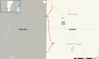
Vermont Route 9 is a state highway in the U.S. state of Vermont. The highway runs 46.957 miles (75.570 km) from the New York state line in Bennington, where it continues west as New York State Route 7, to the New Hampshire state line at the Connecticut River in Brattleboro, where the highway continues as New Hampshire Route 9. VT 9 is the primary east–west highway of Bennington and Windham counties in southern Vermont. The highway connects Southern Vermont's primary towns of Bennington and Brattleboro via its crossing of the Green Mountains. VT 9 also connects those towns with Troy, New York, and Keene, New Hampshire, via the connecting highways in those states. The highway also intersects three major north–south routes: U.S. Route 7 in Bennington and Interstate 91 (I-91) and US 5 in Brattleboro.

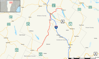
Vermont Route 30 (VT 30) is a 111.870-mile-long (180.037 km) north–south state highway in the U.S. state of Vermont. VT 30 runs from U.S. Route 5 and VT 9 in Brattleboro to US 7 and VT 125 in Middlebury. The northern portion, from Poultney to Middlebury, was part of the New England road marking system's Route 30, from which VT 30 got its number. The route passes through many historic small towns, and travel writers such as those at Southern Vermont have described the route as "idyllic" and "picturesque".

Vermont Route 114 (VT 114) is a 53.094-mile-long (85.447 km) north–south state highway in northeastern Vermont in the United States. It runs northward from U.S. Route 5 (US 5) in Lyndon until nearing the Canada–United States border in the town of Norton; thereafter, the road continues east to the New Hampshire state line in Canaan. The vast majority of VT 114 is situated within Essex County; however, the route also passes through small, isolated portions of Caledonia and Orleans Counties.

Vermont Route 67 (VT 67) is a 4.254-mile-long (6.846 km) east–west state highway in Bennington County, Vermont, United States. It runs from a continuation of New York State Route 67 at the New York state line in Shaftsbury to VT 7A farther east in the town. VT 67 also passes through the village of North Bennington.

Vermont Route 153

Vermont Route 153 (VT 153) is a state highway in southwestern Vermont in the United States. It extends for 13.14 miles (21.15 km) from the New York state line at Rupert to VT 30 in Pawlet. VT 153 is entirely town-maintained and goes through Bennington and Rutland counties.

Vermont Route 132 (VT 132) is a 16.877-mile-long (27.161 km) state highway in eastern Vermont, United States. It runs east to west from VT 14 in Sharon in the west to U.S. Route 5 in Norwich 300 yards (270 m) from the New Hampshire border in the east. The route interchanges with Interstate 89 (I-89) at exit 2, an interchange situated 300 yards (274 m) from the VT 14 junction. The segment of VT 132 from VT 14 to the ramp from I-89 northbound is maintained by the state; the remainder is town-maintained.

U.S. Route 7 in Vermont Section of U.S. Highway in Vermont

U.S. Route 7 (US 7) is a north–south highway extending from southern Connecticut to the northernmost part of Vermont. In Vermont, the route extends for 176 miles (283 km) along the western side of the state as a mostly two-lane rural road, with the exception of an expressway section between Bennington and East Dorset. US 7 is known as the Ethan Allen Highway for its entire length through the state. US 7 ends at an interchange with Interstate 89 (I-89) in the town of Highgate, just south of the Canadian border. I-89 continues to the border crossing.

Vermont Route 23 (VT 23) is a 7.370-mile-long (11.861 km) north–south state highway in Addison County, Vermont, United States. It is maintained by the towns of Middlebury and Weybridge and runs north from VT 125 in Middlebury to VT 17 in Weybridge.

Vermont Route 127 Highway in Vermont

Vermont Route 127 (VT 127) is a state highway in Chittenden County, Vermont, United States. It currently exists in two segments: a signed, locally maintained portion in the city of Burlington and the town of Colchester, and an unsigned, state-maintained portion within the town of Colchester. The southern terminus of the signed segment is at Pearl Street in downtown Burlington. Its northern terminus is at U.S. Route 2 and U.S. Route 7 in Colchester. The unsigned segment is little more than the southern leg of a wye connection between US 2 / US 7 and VT 2A.

Vermont Route 129 Highway in Vermont

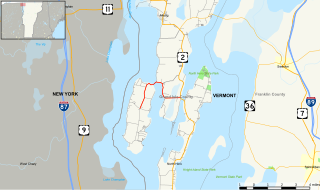
Vermont Route 129 (VT 129) is a short, 5.415-mile-long (8.715 km) connector route for Isle La Motte and Alburgh in the state of Vermont in the United States. VT 129 begins at an intersection in the centre of Isle La Motte, heads northward and terminates at an intersection with U.S. Route 2 in Alburgh. The route originated as Vermont Route F-2 in 1926, and was the name of the road that approached a ferry to Chazy. Route F-2 followed the same routing as the current VT 129, to which it was renumbered in 1944.

Vermont Route 8A (VT 8A) is a 3.300-mile-long (5.311 km) state highway in Windham County, Vermont, United States. It is the northward continuation of Massachusetts' Route 8A, running entirely in the town of Whitingham. The road is numbered as a state route but is maintained by the town of Whitingham as a class-2 town highway. For this reason, it is signed with a black-and-white circular shield; however, one green-and-white shield exists at VT 112's northern end that erroneously denotes VT 8A as a state-maintained highway.

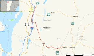
Vermont Route 36 (VT 36) is a 29.431-mile-long (47.365 km) state highway in Franklin County, Vermont, United States. It is an L-shaped highway running south and east from VT 78 in the village of Swanton in the north to VT 108 in the town of Bakersfield in the east. The portion from St. Albans Bay State Park to the eastern terminus in Bakersfield is maintained by the state, while the north–south portion is a town highway minor collector.

Vermont Route 73 (VT 73) is a 36.674-mile-long (59.021 km) east–west state highway in central Vermont, United States. It extends from VT 74 in Shoreham in the west to VT 100 in Rochester in the east. The route runs through parts of Addison, Rutland, and Windsor counties. The portion of VT 73 west of VT 22A is town-maintained and internally designated by VTrans as Major Collector 156 while the remainder of VT 73 is maintained by the state.

Vermont Route 207 (VT 207) is a 13.821-mile-long (22.243 km) north–south state highway in Franklin County, Vermont, United States. It begins in the town of St. Albans at U.S. Route 7 (US 7) and runs north to the small village of Morses Line within the town of Franklin, where it intersects VT 235, approximately 0.5 miles (0.8 km) south of the Canada–US border. North of VT 78, the route is town-maintained and internally designated as major collector 297.

Vermont Route 242 (VT 242) is a 12.878-mile-long (20.725 km) state highway located in Franklin and Orleans counties, Vermont, United States. The route begins at an intersection with VT 118 in the town of Montgomery and runs through the Green Mountains of Vermont past Jay Peak to a junction with VT 101 in the town of Troy. The route was first designated by the state of Vermont in 1959 from the town of Jay to Troy, with the piece in the town of Montgomery being added five years later. In 1972, the segment in Westfield and Jay that connected the two segments was added to the state highway system.

Vermont Route 104 State highway

Vermont Route 104 (VT 104) is a state highway in the U.S. state of Vermont. The highway runs 20.503 miles (32.996 km) from VT 15 in Cambridge to VT 105 in the town of St. Albans. VT 104 is an L-shaped route that connects the city of St. Albans and Cambridge via Fairfax. The highway has an auxiliary route, VT 104A, that connects Fairfax and Georgia to the west.

References

http://www.vpr.net/news_detail/90914/

  1. State Numbered Town Highway Sign Details
  2. http://www.aot.state.vt.us/planning/Documents/Planning/2012VTransFactbook.pdf [ bare URL PDF ]
  3. 1 2 3 4 Briggs, John (June 17, 2012). "Looking for a sign". Burlington Free Press . Burlington, Vermont. pp. 1A, 8A–9A.
  4. Traffic Research Unit (June 2016). "2015 (Route Log) AADTs: State Highways" (PDF). Technical Services Section, Vermont Agency of Transportation. pp. 7–8. Retrieved February 20, 2017.
  5. "L'autoroute 35 sera complétée d'ici 2023" (in French). Agence QMI. Retrieved 3 June 2020.
  6. 1 2 Traffic Research Unit (June 2016). "2015 (Route Log) AADTs: State Highways" (PDF). Technical Services Section, Vermont Agency of Transportation. pp. 11–26. Retrieved February 20, 2017.
  7. Traffic Research Unit (June 2016). "2015 (Route Log) AADTs: State Highways" (PDF). Technical Services Section, Vermont Agency of Transportation. pp. 29–66. Retrieved February 22, 2017.
  8. Traffic Research Unit (June 2015). "2014 (Route Log) AADTs: Major Collectors" (PDF). Technical Services Section, Vermont Agency of Transportation. pp. 3–17. Retrieved February 22, 2017.
  9. 1 2 3 "State Changes Route Numbers as Tourist Aid". The Burlington Free Press. December 31, 1959. p. 4. Retrieved May 2, 2018 via Newspapers.com. Open Access logo PLoS transparent.svg
  10. 1 2 3 "Despite Delays in Federal Road Funds Holden Advises Highway Board to Maintain Preliminary Work". The Burlington Free Press. December 8, 1966. p. 36. Retrieved January 5, 2018 via Newspapers.com. Open Access logo PLoS transparent.svg
  11. 1 2 3 "Vermont Highway Routes to be Revised in the Spring". The Bennington Banner. September 24, 1960. p. 2. Retrieved November 4, 2015 via Newspapers.com. Open Access logo PLoS transparent.svg
  12. 1 2 "New State Route Numbers in Stamford, Readsboro". The Bennington Banner. April 23, 1964. p. 14. Retrieved November 4, 2015 via Newspapers.com. Open Access logo PLoS transparent.svg
  13. 1 2 3 "3 Addison County Route Numbers Will be Changed". The Burlington Free Press. August 20, 1953. p. 9. Retrieved May 2, 2018 via Newspapers.com. Open Access logo PLoS transparent.svg
  14. Vermont Agency of Transportation Program Development Division Traffic Research Unit, 2004 (Route Log) AADTs State Highways Archived 2007-10-27 at the Wayback Machine , July 2005
  15. Mapping Section (November 15, 2016). "VTrans Route Logs and Progress Charts". Named State Highways. Policy, Planning, and Intermodal Development Division, Vermont Agency of Transportation . Retrieved February 19, 2017.