
Guam is an organized, unincorporated territory of the United States in the Micronesia subregion of the western Pacific Ocean. Guam's capital is Hagåtña, and the most populous village is Dededo. It is the westernmost point and territory of the United States, reckoned from the geographic center of the U.S. In Oceania, Guam is the largest and southernmost of the Mariana Islands and the largest island in Micronesia.

The Mariana and Palau Islands campaign, also known as Operation Forager, was an offensive launched by United States forces against Imperial Japanese forces in the Mariana Islands and Palau in the Pacific Ocean between June and November 1944 during the Pacific War. The United States offensive, under the overall command of Chester W. Nimitz, followed the Gilbert and Marshall Islands campaign and was intended to neutralize Japanese bases in the central Pacific, support the Allied drive to retake the Philippines, and provide bases for a strategic bombing campaign against Japan.

Hagåtña is the capital village of the United States territory of Guam. From the 18th through mid-20th century, it was Guam's population center, but today it is the second smallest of the island's 19 villages in both area and population. However, it remains one of the island's major commercial districts in addition to being the seat of government.

Tamuning, also known as Tamuning-Tumon-Harmon is a village located on the western shore of the United States territory of Guam. The village of Tamuning is the economic center of Guam, containing tourist center Tumon, Harmon Industrial Park, and other commercial districts. Its central location along Marine Corps Drive, the island's main thoroughfare, has aided in its development.

The Battle of Guam was the American recapture of the Japanese-held island of Guam, a U.S. territory in the Mariana Islands captured by the Japanese from the United States in the First Battle of Guam in 1941 during the Pacific campaign of World War II. The battle was a critical component of Operation Forager. The recapture of Guam and the broader Mariana and Palau Islands campaign resulted in the destruction of much of Japan's naval air power and allowed the United States to establish large airbases from which it could bomb the Japanese home islands with its new strategic bomber, the Boeing B-29 Superfortress.

Hågat is a village in the United States territory of Guam. It is located south of Apra Harbor on the island's western shore. The village's population has decreased since the island's 2010 census.

Asan-Maina is a village located on the western shore of the United States territory of Guam. The municipality combines the names of the coastal community of Asan with Maina, a community along the slopes of the Fonte River valley to the east. Asan was the northern landing site for United States Marines during Guam's liberation from the Japanese during World War II. Asan Beach Park is part of the War in the Pacific National Historic Park. The third community comprising Asan-Maina is Nimitz Hill Annex in the hills above Asan and Maina, which is the location of the Joint Region Marianas headquarters. Asan-Maina is located in the Luchan (Western) District.

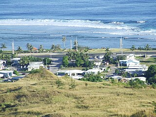
Piti is a village located on the central west coast of the United States territory of Guam. It contains northern and eastern coastlines of Apra Harbor, including Cabras Island, which has the commercial Port of Guam and the island's largest power plants. Piti was a pre-Spanish CHamoru village and, after Spanish colonization, became the primary port town on Guam. The town was largely destroyed during the 1944 liberation of Guam and the population relocated during the wartime construction of Apra Harbor.

Yona is a village in the United States territory of Guam.

The War in the Pacific National Historical Park is a multi-unit protected area in the United States territory of Guam, which was established in 1978 in honor of those who participated in the Pacific Theater of World War II. Uniquely among the National Park System, it honors the bravery and sacrifices of all those who participated in the Pacific Theater.

3rd Battalion, 3rd Marines, abbreviated as (3/3), was an infantry battalion of the United States Marine Corps, based out of Kaneohe, Hawaii. Known as either "Trinity" or "America's Battalion", the unit normally fell under the command of the 3rd Marine Regiment of the 3rd Marine Division. When fully manned, the unit consisted of approximately 1000 U.S. Marines and United States Navy Sailors. Like most 20th century model infantry battalions of the U.S. Marine Corps, 3rd Battalion 3rd Marines was made up of three rifle companies, and a Headquarters and Services (H&S) company. The battalion was originally formed at Marine Corps Base Camp Lejeune, North Carolina in 1942 and saw action on both Bougainville and Guam during World War II, where it was awarded its first Presidential Unit Citation and Navy Unit Commendation. Marines in the battalion were also awarded one Medal of Honor and seven Navy Crosses during the war.

Vicente Tomás Garrido Blaz, also known as Ben Blaz, was a Chamorro United States Marine Corps Brigadier General from the United States territory of Guam. Blaz served in the Marine Corps from 1951 until July 1, 1980. Prior to his retirement, he served as the Deputy Chief of Staff for Reserve Affairs, Headquarters Marine Corps, Washington, D.C.

Allen Hal Turnage was a United States Marine Corps General who earned the Navy Cross and the Distinguished Service Medal while leading the 3rd Marine Division on Bougainville and Guam in World War II.

Guam Highway 1 (GH-1), also known as Marine Corps Drive, is one of the primary automobile routes in the United States territory of Guam. It runs in a southwest-to-northeast direction, from the main gate of Naval Base Guam in the southwestern village of Santa Rita in a northeasterly direction to the main gate of Andersen Air Force Base in the village of Yigo. It passes through Guam's capital, Hagåtña, as well as intersecting other territorial highways. The highway runs through tropical forest, urbanized commercial areas, and residential neighborhoods. The US military upgraded and extended the road starting in 1941. Construction ceased with the Japanese invasion in December 1941 and resumed after the Second Battle of Guam in 1944. The highway was formally dedicated to the U.S. Marine Corps by the governor in 2004.
The Japanese occupation of Guam was the period in the history of Guam between 1941 and 1944 when Imperial Japanese forces occupied Guam during World War II. The island was renamed Ōmiya-Jima.

Orote Field is a former air base in the United States territory of Guam built by the Empire of Japan with Chamorro forced labor during the Japanese occupation of Guam (1941-1944). It is separate from the Marine Corps amphibious airplane base at located at Sumay village that was operational from 1921 to 1931. Following the liberation of Guam in 1944, the U.S. military repaired the field for further use in the Pacific War.

Barrigada is a village in the United States territory of Guam. A largely residential municipality, its main village is located south of the Antonio B. Won Pat International Airport near the intersections of Routes 8, 10, and 16. The community east of the airport known as Barrigada Heights is considered an affluent neighborhood on the island, where homes have excellent views overlooking much of Guam including the island's airport and hotels along Tumon Bay. Another significant location is Mount Barrigada, nearly 200 meters above sea level. Its location in the center of the island means it houses most of the island's radio masts and towers; the position and height make it easier for radio signals to reach the entire island.

Liberation Day on the U.S. territory of Guam is an annual commemoration of the invasion by U.S. military forces on July 21, 1944, which ended the Japanese occupation that had begun in 1941. Begun in 1945, it is Guam's largest celebration. Festivities include a queen contest, summer carnival, fireworks display, and mile-long parade on Marine Corps Drive in Hagåtña from Adelup to Paseo de Susana, as well as solemn memorials and visits to massacre sites. It is organized by the Guam Island Fair Committee.
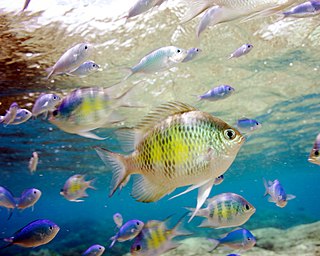
Piti Bomb Holes Marine Preserve is a marine protected area comprising all of Piti Bay on the western coast of Guam, located off of the village of Piti in the Philippine Sea. The defining "bomb hole" features, named because they look like bomb craters in the reef flat, are actually natural percolation pits where fresh water filters into the shallow lagoon at a depth of 25 to 30 feet. The largest pit houses the commercial Fish Eye Marine Park tourist attraction, which includes a wooden pier to a underwater observatory and a Seawalker tour of the lagoon bottom. It is visited by more than 200,000 people annually. The Piti preserve is the most ecologically diverse of Guam's five marine preserves. The pit around Fish Eye is a popular snorkeling and recreational diving site.
Asan is a community and census-designated place (CDP) along the western coast of the U.S. territory of Guam. Asan, along with Maina and Nimitz Hill Annex, are the three communities in the village of Asan-Maina. It is known for being the location of northern invasion beach used by the United States during the retaking of Guam in 1944.
