State Road 37 (SR 37) is a major route in the U.S. state of Indiana, running as a four-lane divided highway for 110 miles of its course.

The Willamette Stone was a small stone obelisk originally installed by the Department of Interior in 1885 in the western hills of Portland, Oregon in the United States to mark the intersection and origin of the Willamette meridian and Willamette baseline. It replaced a cedar stake placed by the Surveyor General of the Oregon Territory in 1851; this stake defined the grid system of sections and townships from which all real property in the states of Oregon and Washington has been measured following the Donation Land Claim Act of 1850. The Willamette meridian runs north–south, and the Willamette baseline runs east–west through the marker. The easternmost northeast corner of Washington County is sited on the marker.
Interstate 465 (I-465), also known as the USS Indianapolis Memorial Highway, is the beltway circling Indianapolis, Indiana, United States. It is roughly rectangular in shape and has a perimeter of approximately 53 miles (85 km). It lies almost completely within the boundaries of Marion County, except for two short sections on the north leg in Boone and Hamilton counties. It intersects with I-65, I-69, I-70, and I-74 and provides additional access to I-65 via I-865.

Roads and expressways in Chicago summarizes the main thoroughfares and the numbering system used in Chicago and its surrounding suburbs.
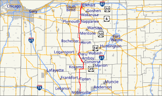
State Road 19 (SR 19) is a route on the Indiana State Highway System that runs between Noblesville and Elkhart in the US state of Indiana. The 143 miles (230.14 km) of Indiana SR 19 serve as a minor highway. Some of the highway is listed on the National Highway System. Various sections are urban four-lane highway and rural two-lane highway. The highway passes through farmland, residential and commercial properties. The northernmost community along the highway is Simonton Lake at the Michigan state line.

State Road 26 is an east–west discontinuous state road in the central part of the US state of Indiana. The western end of the western segment is at the Illinois border, where it continues as Illinois Route 9. The highway passes through rural areas of Warren and Tippecanoe counties, before ending near West Lafayette. The eastern segment begins at an interchange with Interstate 65 (I-65) and heads east passing through the cities of Kokomo, Hartford City, and Portland, before ending at the Ohio border, where it continues east as Ohio State Route 119. The road covers a distance of about 150.1 miles (241.6 km), passing through mostly rural areas.

State Road 51 in the U.S. state of Indiana is a north–south route on the state highway system in northwest Indiana. It consists of a route 9.56 miles (15.39 km) long from a point on U.S. Route 30 4 miles (6.4 km) east of Merrillville and 8 miles (13 km) west of Valparaiso, north to U.S. Route 20 in Gary. Immediately north of US 30, the highway is signed as the Adam Benjamin Highway.
State Road 67 in the U.S. State of Indiana cuts a diagonal route from southwest to northeast across the state from the north side of Vincennes to Indianapolis to the Ohio state line, where it becomes State Route 29 east of Bryant.
State Road 933 (SR 933) is an Indiana State Road that runs between Elkhart and South Bend in US state of Indiana. The 16.83 miles (27.09 km) of SR 933 that lie within the state serve as a major conduit. None of the highway is listed on the National Highway System. Various sections are urban two-lane highway and urbanized four-lane divided highway. The highway passes through residential and commercial properties.

State Road 15 is a north–south state road in northern part of the US state of Indiana. Its southern terminus is at U.S. Highway 35 and SR 22 near Jonesboro and its northern terminus is the Michigan state line, north of Bristol, where the roadway continues north as M-103. It is a surface highway that mostly passes farm fields but passing through a few cities of Marion, Wabash, Warsaw, and Goshen. Running for 94.835 miles (152.622 km) through the state, SR 15 is maintained by the Indiana Department of Transportation (INDOT).

State Road 63 (SR 63) in the U.S. state of Indiana is a north–south route in the western portion of the state. Until mid-2008, it covered a distance of just over 96 miles (154 km), but now is a discontinuous route. For 63 miles (101 km), from the city of Terre Haute until it rejoins U.S. Route 41 (US 41) near Carbondale, it is a four-lane divided highway and replaces US 41 as the major north–south artery in this portion of the state.
US Highway 27 (US 27) is a part of the United States Numbered Highway System that runs from Miami, Florida, to Fort Wayne in the US state of Indiana. In Indiana, it is a State Road that enters the state in College Corner, Ohio, and West College Corner, Indiana. The 117.78 miles (189.55 km) of US 27 that lie within Indiana serve as a major conduit. Most of the highway is listed on the National Highway System. Various sections are rural two-lane highway, urbanized four-lane divided highway. The northernmost community along the highway is Fort Wayne in the northeast part of the state. The highway ends at an interchange with Interstate 69 (I–69) north of downtown Fort Wayne after serving the east central and northeast regions of Indiana.
The roads and freeways in metropolitan Detroit comprise the main thoroughfares in the region. The freeways consist of an advanced network of interconnecting freeways which include Interstate highways. The Metro Detroit region's extensive toll-free freeway system, together with its status as a major port city, provide advantages to its location as a global business center. There are no toll roads in Michigan.
U.S. Route 6 (US 6) is a part of the United States Numbered Highway that runs from California to Provincetown, Massachusetts. In Indiana, it is part of the Indiana State Road system that enters the state concurrent with the Borman Expressway between Lansing, Illinois, and Munster, Indiana. The 149.0 miles (239.8 km) of US 6 that lie within Indiana serve as a major conduit. Some sections of the highway is listed on the National Highway System. Various sections are rural two-lane highway and urbanized four-lane divided highways. The easternmost community along the highway is Butler at the Ohio state line.
U.S. Route 33 (US 33) is part of the United States Numbered Highway System that runs from Richmond, Virginia to Elkhart of the US state of Indiana. In Indiana, it is a state road that enters the state at the Ohio state line between Willshire, Ohio, and Pleasant Mills, Indiana. The 106.217 miles (170.940 km) of US 33 that lie within Indiana serve as a major conduit. All of the highway is listed on the National Highway System. Various sections are rural two-lane highway, urbanized four-lane divided expressway and the Lincoln Highway. The northernmost community along the highway is Elkhart. The highway ends at an interchange in southern Elkhart after serving the northeastern region of Indiana. US 33 passes through farm fields and urban areas.
U.S. Route 20 (US 20) in Indiana is a main east–west highway that is parallel to the Indiana Toll Road. The western terminus of US 20 is at the Illinois state line and the eastern terminus is at the Ohio state line. US 20 through Whiting, East Chicago, and Gary is concurrent with US 12 twice. The route varies between one-way, two-lane, and four-lane streets, in northwestern Indiana. From the east side of Gary to west of South Bend, US 20 is a four-lane undivided highway. The route then heads around the west and south sides of South Bend and Elkhart as a four-lane limited access divided highway. East of State Road 15 (IN-15), US 20 is two-lane rural highway.
U.S. Route 31 (US 31) is a part of the United States Numbered Highway System that runs from Spanish Fort, Alabama, to Mackinaw City, Michigan. It enters the U.S. state of Indiana via the George Rogers Clark Memorial Bridge between Louisville, Kentucky, and Clarksville, Indiana. The 266.02 miles (428.12 km) of US 31 that lie within Indiana serve as a major conduit. Some of the highway is listed on the National Highway System. Various sections are rural two-lane highway and urbanized four- or six-lane divided expressway. The northernmost community along the highway is South Bend near the Michigan state line.

U.S. Route 231 in Indiana is a main north–south highway in the western part of the state. The southern terminus of US 231 is at the Kentucky state line and the northern terminus is at US 41 just south of St. John. The highway is a mixture of expressway and two-lane roadway. The expressway is mainly in southern Indiana and around the Lafayette area, with the rest mainly being two-lanes.


