
Interstate 97 (I-97) is a north-south Interstate Highway in the eastern United States. It runs entirely within Anne Arundel County, Maryland for 17.62 miles (28.36 km) from U.S. Route 50/U.S. Route 301 (US 50/US 301) in Parole near Annapolis north to I-695 and I-895 in Brooklyn Park near Baltimore. The interstate is the primary highway between Baltimore and Annapolis. I‑97 connects Annapolis with Baltimore/Washington International Airport and links the northern Anne Arundel County communities of Crownsville, Millersville, Severna Park, Glen Burnie, and Ferndale. It is the second shortest primary Interstate Highway after I-87 in North Carolina.

Interstate 795 (I-795), also known as the Northwest Expressway, is a nine-mile (14 km) auxiliary Interstate Highway linking Baltimore's northwestern suburbs of Pikesville, Owings Mills, and Reisterstown, Maryland, to the Baltimore Beltway (I-695). The route bypasses Maryland Route 140, carrying part of the Maryland Transit Administration (MTA)'s Baltimore Metro SubwayLink in its median for a four-mile (6.4 km) stretch, and provides direct access to the former Owings Mills Mall. It never connects to its parent, I-95, except via I-695.

Interstate 895 (I-895) is an auxiliary Interstate Highway in the US state of Maryland. Known as the Harbor Tunnel Thruway, the highway runs 11.44 miles (18.41 km) between one junction with I-95 in Elkridge and another interchange with I-95 on the east side of Baltimore. I-895 is a toll road that crosses the Patapsco River estuary via the Baltimore Harbor Tunnel, connecting U.S. Route 1 (US 1), I-695, and the Baltimore–Washington Parkway in the southwestern suburbs of Baltimore with US 40 on the east side of Baltimore. In conjunction with a pair of spurs, unsigned I-895A and I-895B, I-895 provides access to the tunnel from I-97 and Maryland Route 2 (MD 2) in Glen Burnie. The highway is designed for through traffic by having partial interchanges that require vehicles from almost all starting points to pass through the tunnel and the tunnel toll plaza, where a $1.40-$6.00 toll is charged to passenger vehicles, before exiting the facility.

Interstate 695 (I-695) is a 51.46-mile-long (82.82 km) auxiliary Interstate Highway that is a full beltway extending around Baltimore, Maryland, United States. I-695 is officially designated the McKeldin Beltway but is colloquially referred to as either the Baltimore Beltway or 695. The route is an auxiliary route of I-95, intersecting that route southwest of Baltimore near Arbutus and northeast of the city near White Marsh. It also intersects other major roads radiating from the Baltimore area, including I-97 near Glen Burnie, the Baltimore–Washington Parkway near Linthicum, I-70 near Woodlawn, I-795 near Pikesville, and I-83 in the Timonium area. The 19.37-mile (31.17 km) portion of the Baltimore Beltway between I-95 northeast of Baltimore and I-97 south of Baltimore is officially Maryland Route 695 (MD 695) and is not part of the Interstate Highway System but is signed as I-695. This section of the route includes the Francis Scott Key Bridge that crosses over the Patapsco River. The bridge and its approaches are maintained by the Maryland Transportation Authority (MDTA) while the remainder of the Baltimore Beltway is maintained by the Maryland State Highway Administration (MDSHA).

Interstate 195 (I-195) is an auxiliary Interstate Highway in the US state of Maryland. The highway runs 4.35 miles (7.00 km) from I-95 in Arbutus east to Maryland Route 170 (MD 170) near the Baltimore/Washington International Airport in Linthicum. I-195, which is also known as Metropolitan Boulevard, is the main connection between the airport terminal and highways leading to Baltimore, Washington, D.C., and Annapolis, including I-95, MD 295, and I-97. The interchange with MD 170, which forms part of the Airport Loop, provides access to various airport-related services. I-195 also links I-95 with Catonsville and the University of Maryland, Baltimore County (UMBC), via a westward continuation of Metropolitan Boulevard that is part of MD 166.

Maryland Route 648 is a collection of state highways in the U.S. state of Maryland. These nine highways are current or former sections of the Baltimore–Annapolis Boulevard between Annapolis and Baltimore via Glen Burnie. There are five signed mainline segments of MD 648 through Arnold, Severna Park, Pasadena, Glen Burnie, Ferndale, and Pumphrey in northern Anne Arundel County; Baltimore Highlands in southern Baltimore County; and the independent city of Baltimore. MD 648 mainly serves local traffic along its meandering route, with long-distance traffic intended to use the parallel and straighter MD 2 south of Glen Burnie and freeway-grade Interstate 97 (I-97), I-695, and MD 295 between Glen Burnie and Baltimore.
Maryland Route 151 (MD 151) is a state highway in the U.S. state of Maryland. Known for most of its length as North Point Boulevard, the state highway runs 10.80 miles (17.38 km) from 7th Street in Sparrows Point north to U.S. Route 1 (US 1) in Baltimore. MD 151 is a four- to six-lane divided highway that connects the communities of Edgemere and Dundalk on the Patapsco River Neck peninsula of southeastern Baltimore County with industrial areas in Sparrows Point and East Baltimore. MD 151 was originally constructed in the early 1920s from Sparrows Point to Edgemere. The highway was connected to Baltimore by the Baltimore County portion of MD 20, a number also assigned to the highway from Rock Hall to Chestertown in Kent County. During World War II, MD 151 was extended north through Dundalk on a new divided highway parallel to MD 20 and through East Baltimore on an expanded Erdman Avenue to connect the Bethlehem Steel complex at Sparrows Point with MD 150 and US 40. In the late 1960s and early 1970s, Interstate 695 (I-695) was constructed parallel to MD 151 between Edgemere and MD 157 in Dundalk.

Charles Street, known for most of its route as Maryland Route 139, runs through Baltimore and the Towson area of Baltimore County. On the north end it terminates at an intersection with Bellona Avenue near Interstate 695 (I-695) and at the south end it terminates in Federal Hill in Baltimore. Charles Street is one of the major routes through the city of Baltimore, and is a major public transportation corridor. For the one-way portions of Charles Street, the street is functionally complemented by the parallel St. Paul Street, Maryland Avenue, Cathedral Street, and Liberty Street.

Maryland Route 702 is a state highway in the U.S. state of Maryland. Known as Southeast Boulevard, the state highway runs 4.17 miles (6.71 km) from Interstate 695 (I-695) in Rosedale east to Back River Neck Road near Essex. MD 702 is a controlled-access spur that serves Essex in southeastern Baltimore County. The state highway was constructed as a freeway from I-695 to Old Eastern Avenue east of MD 150 in the early 1970s. MD 702 was extended as a divided highway to its present terminus around 1990. Documentation from the Maryland State Highway Administration depict the highway as following an east–west alignment, but all signage indicates a north–south road.

Maryland Route 157 is a state highway located in Baltimore County in the U.S. state of Maryland. The state highway runs 4.79 miles (7.71 km) from MD 158 in Sparrows Point north to North Point Road in Dundalk. MD 157 is an L-shaped highway serves as the primary highway through Dundalk and from Dundalk to Interstate 695 (I-695). The two highways to which MD 157 is assigned, Merritt Boulevard and Peninsula Expressway, were constructed as a four-lane divided county highway in the early 1960s. In the late 1960s, Merritt Boulevard was extended as ramps to I-695 that also serve MD 151 and MD 150. MD 157 was assigned to the highway in Sparrows Point in the early 1990s and extended through Dundalk to its present northern terminus in the late 1990s.

Maryland Route 122 is a state highway in the U.S. state of Maryland. Known as Security Boulevard and Cooks Lane, the state highway runs 2.96 miles (4.76 km) from Rolling Road east to the Baltimore city limit within the western Baltimore County suburb of Woodlawn. MD 122 serves the headquarters of the Social Security Administration and connects the agency with MD 570, I-695, and U.S. Route 40. Security Boulevard was constructed in 1960 concurrent with the completion of the Social Security Administration's new headquarters. The six-lane divided highway and the Baltimore County portion of Cooks Lane were transferred from county to state maintenance around 1991.

Maryland Route 43 is a state highway in the U.S. state of Maryland. Known as White Marsh Boulevard, the state highway runs 8.65 miles (13.92 km) from Interstate 695 (I-695) near Parkville east to MD 150 in Middle River. MD 43 is a four-lane divided highway in eastern Baltimore County that connects the northern and eastern suburbs of Baltimore with the commercial center of White Marsh, where the highway has junctions with I-95 and U.S. Route 40. The state highway was built from west of I-95 to US 40 concurrent with the construction of I-95 in the early 1960s. MD 43 was extended west to Parkville in the early 1990s and east to Middle River in 2006.

Interstate 81 (I-81) is a part of the Interstate Highway System that runs from Dandridge, Tennessee, to Fishers Landing, New York. In Maryland, the Interstate Highway runs 12.08 miles (19.44 km) from the West Virginia state line at the Potomac River in Williamsport north to the Pennsylvania state line near Maugansville. I-81 is the primary north–south Interstate Highway in Washington County, connecting Hagerstown with Chambersburg and Harrisburg to the north and Martinsburg, Winchester, and Roanoke to the south.

Interstate 70 (I-70) is a part of the Interstate Highway System that runs from Cove Fort, Utah, to Woodlawn just outside of Baltimore, Maryland. In Maryland, the Interstate Highway runs 91.85 miles (147.82 km) from the Pennsylvania state line in Hancock east to the Interstate's eastern terminus at its junction with I-695. I-70 is the primary east–west Interstate in Maryland; the Interstate Highway connects Baltimore—and Washington, D.C., via I-270—with Western Maryland. The Interstate serves Frederick and Hagerstown directly and provides access to Cumberland via its junction with I-68 at Hancock. I-70 runs concurrently with its predecessor highway, U.S. Route 40 (US 40), from Hancock to Indian Springs in Washington County and from Frederick to West Friendship in Howard County.

Maryland Route 665 is a state highway in the U.S. state of Maryland. Known as Aris T. Allen Boulevard, the state highway runs 2.68 miles (4.31 km) from U.S. Route 50 /US 301 in Parole east to Bywater Road and Forest Drive in Annapolis. MD 665 is a four-lane divided highway that connects US 50/US 301 and Interstate 97 (I-97) with MD 2 and the southern part of Annapolis and adjacent unincorporated communities on the Annapolis Neck in central Anne Arundel County. MD 665 was assigned to Forest Drive from MD 2 east to Bay Ridge Avenue circa 1950. The highway was relocated at its intersections with MD 387 and Bay Ridge Road in the 1960s. The Forest Drive iteration of MD 665 was removed from the state highway system in the late 1980s immediately before construction began on modern MD 665, which opened in 1992.
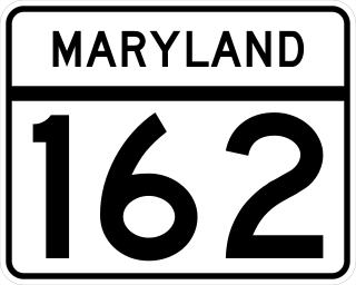
Maryland Route 162 is a state highway in the U.S. state of Maryland. Known as Aviation Boulevard, the highway runs 2.31 miles (3.72 km) from MD 176 near Ferndale north to MD 170 in Linthicum in northern Anne Arundel County. MD 162 forms the eastern portion of the Airport Loop that circumscribes Baltimore/Washington International Thurgood Marshall Airport and connects the airport with Interstate 97 (I-97). Most of what is now MD 162 was Maryland Route 167 in the late 1960s and early 1970s; MD 167 previously had been assigned to a different portion of Hammonds Ferry Road in Linthicum from the 1930s to the early 1960s. MD 162 was assigned along the length of MD 167's second route in the late 1980s and immediately relocated at its northern end. The remainder of the highway was expanded to a divided highway in the 1990s.
The Maryland highway system is a network of highways owned and maintained by the U.S. state of Maryland. In addition to the nationally numbered Interstate Highways and U.S. Highways, the highway system consists of a network of Maryland state-numbered highways. All three types of highways together provide access to all incorporated and unincorporated areas in all 23 counties of Maryland as well as the independent city of Baltimore.

U.S. Route 1 Alternate is an alternate route of US 1 in the U.S. state of Maryland. The highway runs 3.92 miles (6.31 km) between intersections with US 1 in Arbutus and in Baltimore. US 1 Alt. serves the southwestern Baltimore County community of Halethorpe and connects US 1 with full-access interchanges with Interstate 95 (I-95) and I-695. The Washington Boulevard portion of the alternate route was the original road southwest from Baltimore in the 18th century and was part of the turnpike southwest to Washington, D.C. for much of the 19th century. The highway was paved in the early 1910s, expanded in the late 1910s and late 1920s, and became part of US 1 in 1926. The Caton Avenue portion of the alternate route was improved and expanded in the 1930s to serve as a rerouting of US 1 in southwest Baltimore. US 1 Alt. was created in 1949 when US 1 was moved to its present course through Arbutus and southwest Baltimore. The alternate route's interchanges with I-695 and I-95 were constructed in the late 1950s and mid-1970s, respectively.


