Makemo

Last updated

Makemo
Makemo2.jpg
NASA picture of Makemo Atoll
Polynesie francaise collectivity location map.svg
Red pog.svg
Makemo
Geography
LocationPacific Ocean
Coordinates 16°35′55″S143°39′41″W / 16.59861°S 143.66139°W / -16.59861; -143.66139
Archipelago Tuamotus
Area603 km2 (233 sq mi) (lagoon)
56 km2 (22 sq mi) (above water)
Length69 km (42.9 mi)
Width16.5 km (10.25 mi)
Administration
France
Overseas collectivity French Polynesia
Administrative subdivision Îles Tuamotu-Gambier
Commune Makemo
Largest settlement Pouheva (pop. 600)
Demographics
Population816 [1] (2022)
Makemo
MakemoISS005-E-15031.PNG
NASA picture of Makemo Atoll.
Localizacion de Makemo en las Tuamotu.png
Location of Makemo
Makemo
Coordinates: 16°35′55″S143°39′41″W / 16.5985°S 143.6613°W / -16.5985; -143.6613
Country France
Overseas collectivity French Polynesia
Subdivision Îles Tuamotu-Gambier
Area
1
100 km2 (40 sq mi)
Population
 (2022) [1]
1,391
  Density14/km2 (36/sq mi)
Time zone UTC-10:00
INSEE/Postal code
98726 /98769
1 French Land Register data, which excludes lakes, ponds, glaciers > 1 km2 (0.386 sq mi or 247 acres) and river estuaries.

Makemo, Rangi-kemo or Te Paritua, [2] is an inhabited atoll in the Tuamotu archipelago in French Polynesia.

Contents

History

Makemo is the home of legendary Polynesian hero Moeava. [3] The first recorded European to arrive to Makemo Atoll was English pearl merchant John Buyers on the brig Margaret. He arrived at Makemo on 10 March 1803 on the same day he discovered Taenga and named the Makemo Atoll "Phillips Island", after a late sheriff of London, Sir Richard Phillips. In some maps Makemo appears as "Kutusov".

In the 19th century, Makemo became a French territory with a population of about 250 indigenous inhabitants around 1850, making it one of the largest in the Tuamotus; it was used as a port for ships. By mid-century, the atoll was evangelized with the founding of St. Joseph Parish in 1851 (which since 2004 also includes churches on Taenga and Nihiru Atolls), followed by the construction of the church of the same name in 1975, attached to the Diocese of Papetee. [4]

Legend

The legend explains that the famous warrior fell in love with Huarei, queen of the island Tepukamaruia. The giant Patira became jealous and the two Warriors challenged each other to combat on the island of Makemo. Moeava arrived first and prepared a giant slingshot. When his rival appeared, he chose a large, round, smooth stone, made a prayer to the god Tu, and killed Patira with a shot to the head. Today, a huge round, smooth stone can be seen in the Makemo lagoon. It is the Moeava stone.

Pacific Experimentation Center

Between 1960 and 2000, a French armed forces research center, euphemistically called Centre d'expérimentation du Pacifique, was located on the island. It participated in the testing of French Nuclear weapons. For this purpose, a military infrastructure was built on the main island, including an airport. This infrastructure will be gradually dismantled. This process began in 2009. Since the research center was a major employer, other forms of employment were created on the island for the population, such as fish farming and tourism. Investments are also being made in the use of solar panels and a desalination plant.

Geography

The atoll is 70 km long and about 10 km wide on average. The total area is 56 km2. The lagoon is the third largest of the Tuamotu with 603 km2, and has two navigable passages. [5] The main village is Pouheua, and the total population is 588 inhabitants in the 1996 census. It has a Catholic church, an elementary school and an airport. The main activity is Pearl farming.

Climate

The climate is tropical, typical of this southern region. The average temperature is 24 °C. The warmest month is March, at 26 °C, and the coldest month is October, at 21 °C.10 Average rainfall is 1,707 millimeters per year. The rainiest month is December, with 326 millimeters of rain, and the driest month, August, with 36 millimeters. [6]

Administration

The commune of Makemo consists of the atolls of Makemo, Haraiki, Marutea Nord, Katiu, Tuanake, Hiti, Tepoto Sud, Raroia, Takume, Taenga and Nihiru. [7]

Demography

In 2022, the total population of Makemo was 816 persons [1] grouped mainly in the village of Pouheva; its evolution is as follows:

1983198819962002200720122017
360373588720728832825
Sources: Statistical Institute of French Polynesia. [8] and Government of French Polynesia.

Pouheva, located near the Arikitamiro Pass (passe d'Arikitamiro), is the main village of the atoll. It has about 600 inhabitants.

Religion

St. Joseph's Church in Makemo Eglise.Makemo.JPG
St. Joseph's Church in Makemo

Most of the population of the Atoll is affiliated with Christianity, as a result of the activity of both Catholic and Protestant missionary groups. The Catholic Church has a main religious building in the area called St. Joseph's Church (Église de Saint-Joseph) [9] which ecclesiastically depends on the Metropolitan Archdiocese of Papeete based on the island of Tahiti.

Economy

Tourism, especially with the development of diving near the two passes, is the main economic sector of the island, along with pearl farming (authorized on only 50 ha of the lagoon), [10] sea cucumber harvesting (in the southern part, below the line linking motu Tahiti Toreu to motu Piupiu) [10] and copra farming. The administrative activities of the commune, which includes eleven surrounding atolls, also develop and provide work. The landing of the Natitua submarine cable and its commissioning in December 2018 allows Makemo to be connected to Tahiti and to the global high-speed Internet. [11]

Beach on Makemo Plage.Makemo.JPG
Beach on Makemo

A small domestic airfield with a 1,500-meter runway was built in 1976. It serves, on average, about 500 flights and 10,000 passengers per year, of which 30% are transit Passengers. [12]

Related Research Articles

<span class="mw-page-title-main">Tuamotus</span> Archipelago in French Polynesia

The Tuamotu Archipelago or the Tuamotu Islands are a French Polynesian chain of just under 80 islands and atolls in the southern Pacific Ocean. They constitute the largest chain of atolls in the world, extending over an area roughly the size of Western Europe. Their combined land area is 850 square kilometres. This archipelago's major islands are Anaa, Fakarava, Hao and Makemo.

<span class="mw-page-title-main">Gambier Islands</span> Archipelago in French Polynesia

The Gambier Islands are an archipelago in French Polynesia, located at the southeast terminus of the Tuamotu archipelago. They cover an area of 27.8 km2 or 10.7 sq mi, and are made up of the Mangareva Islands, a group of high islands remnants of a caldera along with islets on the surrounding fringing reef, and the uninhabited Temoe atoll, which is located 45 km south-east of the Mangareva Islands. The Gambiers are generally considered a separate island group from Tuamotu both because their culture and language (Mangarevan) are much more closely related to those of the Marquesas Islands, and because, while the Tuamotus comprise several chains of coral atolls, the Mangareva Islands are of volcanic origin with central high islands.

<span class="mw-page-title-main">Tepoto (South)</span> Atoll in French Polynesia

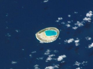
Tepoto Atoll, or Ti Poto, is a small atoll of the Tuamotu Archipelago in French Polynesia. It is located 44 kilometres southwest of Makemo Atoll.

<span class="mw-page-title-main">Rangiroa</span> Atoll in French Polynesia

Rangiroa or Te Kokōta is the largest atoll in the Tuamotus and one of the largest in the world.

<span class="mw-page-title-main">Manihi</span> Atoll in French Polynesia

Manihi, or Paeua, is a coral atoll in the Tuamotu Archipelago, part of French Polynesia. It is one of the northernmost of the Tuamotus, located in the King George subgroup. The closest land to Manihi is Ahe Atoll, located 14 km to the west. The population is 648 inhabitants.

<span class="mw-page-title-main">Hao (French Polynesia)</span> Atoll in French Polynesia

Hao, or Haorangi, is a large coral atoll in the central part of the Tuamotu Archipelago. It has c. 1000 people living on 35 km2 (14 sq mi). It was used to house the military support base for the nuclear tests on Mururoa. Because of its shape, French explorer Louis Antoine de Bougainville named it "Île de la Harpe".

<span class="mw-page-title-main">Anaa</span> Atoll in French Polynesia

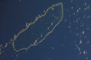
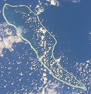
Anaa, Nganaa-nui is an atoll in the Tuamotu archipelago, in French Polynesia. It is located in the north-west of the archipelago, 350 km to the east of Tahiti. It is oval in shape, 29.5 km in length and 6.5 km wide, with a total land area of 38 km2 and a population of 504. The atoll is made up by eleven small barren islands with deeper and more fertile soil than other atolls in the Tuamotus. The lagoon is shallow, without entrance, and formed by three main basins. Although it does not have any navigable access, the water of the lagoon renews by several small channels that can be crossed walking.

<span class="mw-page-title-main">Nukutavake</span> Atoll in French Polynesia

Nukutavake or Nukutuvake is an island in the Tuamotu group in French Polynesia. It lies 1125 km from Tahiti. The closest land is small Pinaki Atoll, located 15 km to the southeast. Vairaatea Atoll lies 38 km to the west of Nukutavake.

<span class="mw-page-title-main">Raroia</span> Atoll in French Polynesia

Raroia, or Raro-nuku, is an atoll of the Tuamotus chain in French Polynesia, located 740 km northeast of Tahiti and 6 km southwest of Takume. Administratively it is a part of the commune of Makemo.

<span class="mw-page-title-main">Fakarava</span> Atoll in French Polynesia

Fakarava, Havaiki-te-araro, Havai'i or Farea is an atoll in the west of the Tuamotu group in French Polynesia. It is the second largest of the Tuamotu atolls. The nearest land is Toau, a coral atoll which lies 14 kilometres to the northwest.

<span class="mw-page-title-main">Tikehau</span> Atoll in French Polynesia

Tikehau or Porutu-kai is a coral atoll in the Palliser Islands group, part of the Tuamotu Archipelago in French Polynesia. It is included in the commune of Rangiroa.

<span class="mw-page-title-main">Takume</span> Atoll in French Polynesia

Takume or Pukamaru is an atoll of the Tuamotus chain in French Polynesia, located 790 km northeast of Tahiti and 6 km northeast of Raroia and 128 kilometres to the west of Fangatau.

<span class="mw-page-title-main">Raeffsky Islands</span> Island group in French Polynesia

The Raeffsky Islands or Raevski Islands is a subgroup with just over 3000 people in the Tuamotu group in French Polynesia. They are located roughly in the central area of the main Tuamotu atoll cluster. Named after Nikolay Raevsky, a Russian general of the Napoleonic wars.

<span class="mw-page-title-main">Marutea Nord</span> Atoll in French Polynesia

Marutea, or Taunga tauranga-e-havana, is one of the Tuamotu atolls in French Polynesia. It is located 24 km to the southeast of Makemo Atoll and 30 km southwest of Nihiru Atoll.

<span class="mw-page-title-main">Nihiru</span> Atoll in French Polynesia

Nihiru, or Nikia, is one of the Tuamotu atolls in French Polynesia. It is a relatively small atoll located 49 km to the east of Makemo Atoll and 30 km northeast of Marutea Atoll.

<span class="mw-page-title-main">Taenga</span> Atoll in French Polynesia

Taenga, or Taunga-hara, is one of the Tuamotu atolls in French Polynesia. It is located 32 km to the northeast of Makemo Atoll and 27 km to the northwest of Nihiru Atoll.

<span class="mw-page-title-main">Haraiki</span> Atoll in French Polynesia

Haraiki is a small atoll of the Tuamotu Archipelago in French Polynesia. It is located 42 km southwest of Marutea Nord.

<span class="mw-page-title-main">Hiti</span> Atoll in French Polynesia

Hiti, or Hiti-rau-mea, is a small atoll of the Tuamotu Archipelago in French Polynesia. It is located 19 km southwest of Makemo Atoll.

<span class="mw-page-title-main">Tuanake</span> Atoll in French Polynesia

Tuanake or Mata-rua-puna is a small atoll located in the Tuamotu Archipelago in French Polynesia. It made up the Raevski Islands subgroup with Tepoto Sud and Hiti. It is administratively attached to the municipality of Makemo.

<span class="mw-page-title-main">Katiu</span> Atoll in French Polynesia

Katiu, or Taungataki, is an atoll of the central Tuamotu Archipelago in French Polynesia. It is located 23.5 kilometres west of Makemo Atoll's westernmost point. It measures 27 kilometres in length with a maximum width of 12.5 kilometres. Its total area, including the lagoon is 232.5 square kilometres and a land area of approximately 10 square kilometres. There are many narrow islands on the north-eastern side of its long reef with a total land area of about 3 square kilometres. Its lagoon is connected to the ocean.

References

  1. 1 2 3 "Les résultats du recensement de la population 2022 de Polynésie française" [Results of the 2022 population census of French Polynesia](PDF) (in French). Institut de la statistique de la Polynésie française. January 2023.
  2. Young, J.L. (1899). "Names of the Paumotu Islands, with the old names so far as they are known". Journal of the Polynesian Society. 8 (4): 264–268. Archived from the original on 10 February 2012. Retrieved 7 January 2015.
  3. Craig, Robert D. (1989). Dictionary of Polynesian Mythology. ISBN   9780313258909.
  4. "MAKEMO SAINT JOSEPH (NIHIRU / TAENGA)". www.diocesedepapeete.com. Retrieved 23 September 2021.
  5. "Tuamotu Archipelago – Makemo". Archived from the original on 23 December 2010. Retrieved 14 March 2009.{{cite web}}: CS1 maint: bot: original URL status unknown (link)
  6. "Rainfall (1 month – TRMM, 1998–2016) | NASA". Rainfall (1 month – TRMM, 1998–2016) | NASA. 23 September 2021. Retrieved 23 September 2021.
  7. Décret n°72-407 du 17 mai 1972 portant création de communes dans le territoire de la Polynésie française, Légifrance
  8. Population, naissances et décès entre deux recensements (RP) Archived 21 September 2021 at the Wayback Machine , Instituto de Estadística de la Polinesia Francesa (ISPF), consulté le 27 février 2019.
  9. "Église de Saint-Joseph". GCatholic. Retrieved 24 September 2021.
  10. 1 2 "Atlas de Polynésie – Tuamotu Gambier – MAKEMO". Direction des Ressources Marines (in French). Retrieved 24 September 2021.
  11. "Numérique en Polynésie : Le câble domestique Natitua est entré en service". Outremers360° (in French). Retrieved 24 September 2021.
  12. "Union des Aéroports Français". www.aeroport.fr. Retrieved 24 September 2021.