
Puka-Puka is a small inhabited coral atoll in the north-eastern Tuamotu Archipelago, sometimes included as a member of the Disappointment Islands. This atoll is quite isolated, the nearest land being Fakahina, 182 km to the southwest.
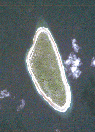
Tepoto, also known as Te Poto, Toho, or Pukapoto, is a coral island. It is the northwesternmost of the Disappointment Islands, in the Tuamotu Archipelago. Despite being often referred to as "atoll", Tepoto is not a typical Tuamotu atoll, but a single separate island without a lagoon. It is located at the limit of the Tuamotu archipelago; the closest land is Napuka, which lies 16 kilometres to the southeast.
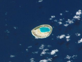
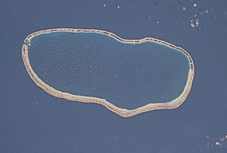
Tepoto Atoll, or Ti Poto, is a small atoll of the Tuamotu Archipelago in French Polynesia. It is located 44 kilometres southwest of Makemo Atoll.

Tenararo is the smallest atoll in the Acteon Group in the southeastern part of the Tuamotu Islands in French Polynesia. It is administratively a part of the Gambier Islands. It is uninhabited.

Tenarunga or Tenania, previously Narunga and formerly Minto Island, is a low, wooded atoll in the Acteon Group in the southeastern part of the Tuamotu Islands in French Polynesia. It is administratively a part of the Gambier Islands. The atoll has a population of between 10 and 50 people.

Hikueru, Tiveru, or Te Kārena, is one of the Central Tuamotu atolls. The closest land to Hikueru is Tekokota Atoll, located 22 km to the north.

Amanu, Timanu, or Karere, is an atoll in the Tuamotu archipelago. Amanu lies at right angles to neighbouring Hao Atoll; this orientation is quite rare for the Tuamotu atolls.

Reitoru, or Te Pirehi, is a small atoll of the Tuamotu Archipelago in French Polynesia. It is located in center of the archipelago, 50 km southwest of Hikueru.
Fakarava, Havaiki-te-araro, Havai'i or Farea is an atoll in the west of the Tuamotu group in French Polynesia. It is the second largest of the Tuamotu atolls. The nearest land is Toau, a coral atoll which lies 14 kilometres to the northwest.

Tatakoto is an atoll in the Tuamotu group in French Polynesia.

Tikei, also known as Manu, Tikai and Tiku is an island in the Tuamotu group in French Polynesia. Tikei is not a typical Tuamotu atoll, as its former lagoon filled in. The island is 3.9 kilometres long, 1.6 kilometres wide, and has a land area of 4 square kilometres. Its highest elevation is 3 metres above sea level

Tikehau or Porutu-kai is a coral atoll in the Palliser Islands group, part of the Tuamotu Archipelago in French Polynesia. It is included in the commune of Rangiroa.
Fakahina, or Kaīna, is a small atoll in the north of the Tuamotu group in French Polynesia. The nearest land is Fangatau Atoll, located 72 km to the north-west. Fakahina's length is 9 kilometres and its maximum width 6.3 kilometres. It has a land area of 11.55 square kilometres and a lagoon area of 20 square kilometres. There is no pass connecting the lagoon with the ocean.
Faaite, or Faaiti is an atoll of the Tuamotus in French Polynesia. It is located 60 kilometres to the north of Anaa Atoll. The total surface of the atoll is 227 square kilometres Its dry land area is 8.87 square kilometres. Its length is 28 kilometres and its width 10.5 kilometres. The total population as of 2012 is 401 inhabitants.

Vairaatea is a small atoll of the Tuamotu group in French Polynesia. Geographically Vairaatea Atoll is part of the East-central subgroup of the Tuamotus, which includes Ahunui, Amanu, Fangatau, Hao and Nukutavake. Nukutavake, the closest land, lies 41 kilometres to the east.

Tuanake or Mata-rua-puna is a small uninhabited atoll located in the Tuamotu Archipelago in French Polynesia. It made up the Raevski Islands subgroup with Tepoto Sud and Hiti. It is administratively attached to the municipality of Makemo.

Katiu, or Taungataki, is an atoll of the central Tuamotu Archipelago in French Polynesia. It is located 23.5 kilometres west of Makemo Atoll's westernmost point. It measures 27 kilometres in length with a maximum width of 12.5 kilometres. Its total area, including the lagoon is 232.5 square kilometres and a land area of approximately 10 square kilometres. There are many narrow islands on the north-eastern side of its long reef with a total land area of about 3 square kilometres. Its lagoon is connected to the ocean.

Tauere Atoll or Taouere, also known as Te Putua, is a small atoll of the central Tuamotu Archipelago in French Polynesia. It is located 85 kilometres northwest of Hao Atoll's westernmost point.

Vanavana, Kurataki, or Huataki is an atoll in the southeastern area of the Tuamotu Archipelago, French Polynesia. Vanavana's nearest neighbour is Tureia, which is located 58 kilometres to the east.

Marokau is an atoll of the Tuamotu Archipelago in French Polynesia. It lies 53 km southeast of Hikueru Atoll and it is separated by a 2 km wide sound from Ravahere, its closest neighbor in the south.

