Mangareva

Last updated

Mangareva
Mangareva.JPG
NASA picture of Mangareva Island
Polynesie francaise collectivity location map.svg
Red pog.svg
Mangareva
Geography
Location Pacific Ocean
Coordinates 23°06′35″S134°58′15″W / 23.10972°S 134.97083°W / -23.10972; -134.97083
Archipelago Gambier Islands
Area15.4 km2 (5.9 sq mi)
Length8 km (5 mi)
Highest elevation441 m (1447 ft)
Highest point Mt. Duff
Overseas collectivity French Polynesia
Administrative subdivision Îles Tuamotu-Gambier
Commune Gambier Islands
Largest settlement Rikitea
Demographics
Population1,239 [1] (2012)

Mangareva is the central and largest island of the Gambier Islands in French Polynesia. It is surrounded by smaller islands: Taravai in the southwest, Aukena and Akamaru in the southeast, and islands in the north. Mangareva has a permanent population of 1,239 (2012) and the largest village on the island, Rikitea, is the chief town of the Gambier Islands.

Contents

The island is approximately eight kilometres (5 mi) long and, at 15.4 km2 (5+1516 sq mi), it comprises about 56% of the land area of the whole Gambier group. Mangareva has a high central ridge which runs the length of the island. The highest point in the Gambiers is Mount Duff, on Mangareva, rising to 441 metres (1,447 ft) along the island's south coast. The island has a large lagoon 24 kilometres (15 mi) in diameter containing reefs whose fish and shellfish helped ancient islanders survive much more successfully than on nearby islands with no reefs.

History

Mangareva was first settled by Polynesians in the first millennium CE. While carbon dating has so far only dated settlements to 1160-1220, [2] there is evidence from the Pitcairn Islands of trade with Mangareva from 1000 CE, and it is likely settlement dates to around 800 CE. [3] The island was once heavily forested and supported a large population that traded with other islands via canoes. However, excessive logging by the islanders between the 10th and 15th centuries resulted in deforestation of the island, with disastrous results for both its environment and its economy (see Gambier Islands for more details). [4]

The first European to visit Mangareva was a British captain, James Wilson, who arrived in 1797 on the ship Duff . [5] Wilson named the island group in honour of Admiral James Gambier, who had helped him to equip his vessel. [6]

Mangareva and its dependencies in the Gambier Islands were ruled by a line of kings – and, later, regents – until the French formally annexed the islands. King Maputeoa requested a French protectorate on 16 February 1844, but the French government never ratified it. On 4 February 1870, the Mangarevan government and its prince regent, Arone Teikatoara, formally withdrew the protectorate request and asked the French not to intervene in the kingdom's affairs. However, after Father Honoré Laval was removed to Tahiti, the native government changed its stance: On 30 November 1871, Prince Regent Arone and the French colonial authority in Tahiti signed an agreement reaffirming the islands’ protectorate status. The Gambier Islands were finally annexed on 21 February 1881 under Prince Regent Bernardo Putairi, and the annexation was approved by the President of France on 30 January 1882. [7]

In the 20th century, in July 1966, the Mangareviens were exposed to radioactive fallout due to the French military's nuclear tests at Moruroa and Fangataufa. Military officials were aware of the doses received by the island and their effects, but kept them secret. [8] The information was made public in 1998 by journalist Vincent Jauvert, [9] and acknowledged by the French government in 2006. [10]

Geography

Climate

Mangareva has a tropical rainforest climate (Köppen climate classification Af). The average annual temperature in Mangareva is 23.5 °C (74.3 °F). The average annual rainfall is 1,913.5 mm (75.33 in) with November the wettest month. The temperatures are highest on average in March, at around 26.0 °C (78.8 °F), and lowest in August, at around 21.3 °C (70.3 °F). The highest temperature ever recorded in Mangareva was 31.4 °C (88.5 °F) on 6 March 2016; the coldest temperature ever recorded was 13.2 °C (55.8 °F) on 27 August 1992.

Climate data for Mangareva (1991–2020 averages, extremes 1980−present)
MonthJanFebMarAprMayJunJulAugSepOctNovDecYear
Record high °C (°F)31.2
(88.2)
30.8
(87.4)
31.4
(88.5)
30.9
(87.6)
29.6
(85.3)
27.5
(81.5)
26.9
(80.4)
28.1
(82.6)
27.7
(81.9)
28.5
(83.3)
29.1
(84.4)
30.1
(86.2)
31.4
(88.5)
Mean daily maximum °C (°F)28.0
(82.4)
28.3
(82.9)
28.4
(83.1)
27.0
(80.6)
25.4
(77.7)
24.1
(75.4)
23.4
(74.1)
23.5
(74.3)
23.8
(74.8)
24.6
(76.3)
25.8
(78.4)
27.0
(80.6)
25.8
(78.4)
Daily mean °C (°F)25.5
(77.9)
25.8
(78.4)
26.0
(78.8)
24.9
(76.8)
23.4
(74.1)
22.2
(72.0)
21.4
(70.5)
21.3
(70.3)
21.5
(70.7)
22.3
(72.1)
23.5
(74.3)
24.7
(76.5)
23.5
(74.3)
Mean daily minimum °C (°F)23.1
(73.6)
23.4
(74.1)
23.6
(74.5)
22.7
(72.9)
21.4
(70.5)
20.3
(68.5)
19.5
(67.1)
19.1
(66.4)
19.3
(66.7)
20.1
(68.2)
21.2
(70.2)
22.3
(72.1)
21.3
(70.3)
Record low °C (°F)18.5
(65.3)
19.3
(66.7)
18.3
(64.9)
17.8
(64.0)
16.0
(60.8)
15.6
(60.1)
13.9
(57.0)
13.2
(55.8)
14.6
(58.3)
14.4
(57.9)
16.6
(61.9)
15.7
(60.3)
13.2
(55.8)
Average precipitation mm (inches)187.4
(7.38)
175.3
(6.90)
167.2
(6.58)
164.8
(6.49)
174.1
(6.85)
155.6
(6.13)
127.9
(5.04)
135.3
(5.33)
119.9
(4.72)
153.7
(6.05)
165.8
(6.53)
186.5
(7.34)
1,913.5
(75.33)
Average precipitation days (≥ 1.0 mm)14.913.213.112.312.312.112.511.210.711.411.313.6148.6
Mean monthly sunshine hours 216.7194.4203.5155.3142.5123.4135.7154.8150.7164.7174.1180.51,996.1
Source: Météo-France [11]

Transportation

Mangareva is reached by boat from the nearby airport across the lagoon.

Mangareva is an important travel link to Pitcairn Island. Practically the only way a traveler can reach Pitcairn Island is to fly to Tahiti, then to Mangareva. From there, a 32-hour boat ride will take the traveler to the island. Some reach Pitcairn by commercial shipping traffic, but that is uncommon, because shipping lanes do not typically pass close to Pitcairn.

Culture and fiction

Painter and author Robert Lee Eskridge's book Manga Reva: The Forgotten Islands (Bobbs Merrill; 1931) offers first-hand observations of the environment, peoples, and traditions of Mangareva. It includes original illustrations and photographs by the author. In 1962, the adventure-fiction writer Garland Roark acknowledged Eskridge's work in a foreword to his novel, The Witch of Manga Reva. Eskridge also wrote and illustrated a children's book about his visit to Mangareva: South Sea Playmates (Bobbs Merrill; 1933). Sailor and author W. I. B. (Bill) Crealock describes in his book Cloud of Islands a visit to Mangareva, which he considered the ideal island, on the yacht Arthur Rogers, in the company of Diana and Tom Hepworth, whose lives were later recounted in the book Faraway by Lucy Irvine.

Binary counting system

The Mangarevan people developed a binary number system centuries ahead of Europeans. [12] In 2013, the islanders were discovered to have developed a novel binary system that allowed them to reduce the number of digits involved in binary counting: for example, representing 150 requires eight digits in binary (10010110) but only four in the Mangarevan system (VTPK, where V (varu) means 80, T (tataua) is 40, P (paua) is 20, and K (takau) is 10). [12] As binary counting is unknown in other Polynesian societies, it most likely developed after Mangareva was settled (which was sometime between 1060 and 1360 AD). [13] Since Gottfried Leibniz would not invent the modern binary number system until 1689, the Mangarevan binary steps prefigured the European invention of binary by as many as 300 to 600 years.

In 2020, Mangarevan binary counting was shown to be an extension of a traditional Polynesian method of counting. [14] Polynesian societies are known to count specific types of objects differently, and they count objects both singly (one by one) and collectively (by twos, fours, or eights). In each case, counting remains decimal (one, two, three...), though the unit counted varies (one, two, four, or eight). In Mangareva, counting collective items decimally produced productive terms for ten (takau or ten singles), twenty (paua or ten pairs), forty (tataua or ten groups of four), and eighty (varu or ten groups of eight). Given the availability of these terms and their associated numerical values, binary counting was then a simple adaptation of traditional Polynesian counting, which set aside every tenth item to mark ten of the items being counted (in New Zealand, this method was misunderstood by Europeans as undecimal or base-11 counting). [14] In the traditional method, the pile of set-asides would then be counted the same way, with every tenth item marking a hundred (second round), thousand (third round), ten thousand items (fourth round), and so on. [15] [16] In Mangarevan binary, in the first round items were counted as before, but in the second round and thereafter they were grouped into eights (varu) and then fours (tataua), twos (paua), and singles (takau). [16] [17] Once counting had shifted to binary units in the second and subsequent rounds, the method was no longer decimal, suggesting an explanation for the upper limit of 800 (for items counted singly) observed for the counting system. [14] [18] [19]

Mythology

Mangarevan mythology includes deities and gods commonly found across the Polynesian triangle. For instance, traditionally, in Mangareva, the most important god was named Tu, whereas in New Zealand and Hawai'i, the god of war was similarly named . [20] Other commonalities amongst the islands of the Polynesian triangle include the goddess Haumea, who is said to have been responsible for the creation of the world, and the demi-god Māui, who is said to have fished up the islands from the bottom of the sea. [20]

Mangareva Island, view from the Motu Totegegie Mangareva.2006.jpg
Mangareva Island, view from the Motu Totegegie

See also

Related Research Articles

<span class="mw-page-title-main">Tuamotus</span> Archipelago in French Polynesia

The Tuamotu Archipelago or the Tuamotu Islands are a French Polynesian chain of just under 80 islands and atolls in the southern Pacific Ocean. They constitute the largest chain of atolls in the world, extending over an area roughly the size of Western Europe. Their combined land area is 850 square kilometres. This archipelago's major islands are Anaa, Fakarava, Hao and Makemo.

<span class="mw-page-title-main">Gambier Islands</span> Archipelago in French Polynesia

The Gambier Islands are an archipelago in French Polynesia, located at the southeast terminus of the Tuamotu archipelago. They cover an area of 27.8 km2 or 10.7 sq mi, and are made up of the Mangareva Islands, a group of high islands remnants of a caldera along with islets on the surrounding fringing reef, and the uninhabited Temoe atoll, which is located 45 km south-east of the Mangareva Islands. The Gambiers are generally considered a separate island group from Tuamotu both because their culture and language (Mangarevan) are much more closely related to those of the Marquesas Islands, and because, while the Tuamotus comprise several chains of coral atolls, the Mangareva Islands are of volcanic origin with central high islands.

<span class="mw-page-title-main">Rikitea</span> Town on Mangareva, part of the Gambier Islands in French Polynesia

Rikitea is a small town on Mangareva, which is part of the Gambier Islands in French Polynesia. A majority of the islanders live in Rikitea. The island was a protectorate of France in 1871 and was annexed in 1881.

Aukena is the 5th largest of the Gambier Islands in French Polynesia. Aukena is located about halfway between Mangareva and Akamaru, or about 5 km southeast of Mangareva, which is the largest island of the whole Gambier Islands archipelago. Aukena is approximately 2.5 km long and about 0.5 km wide, with a total area of 1.35 km2.

Mangareva, Mangarevan is a Polynesian language spoken by about 600 people in the Gambier Islands of French Polynesia and by Mangarevians emigrants on the islands of Tahiti and Moorea, located 1,650 kilometres (1,030 mi) to the North-West of the Gambier Islands.

<span class="mw-page-title-main">Totegegie Airport</span> Airport in Totegegie, French Polynesia

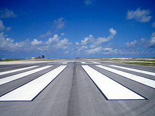
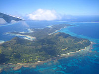
Totegegie Airport is an airport on Totegegie Island in the Gambier Islands, French Polynesia. It is 9 km northeast of the village of Rikitea.

<span class="mw-page-title-main">Index of French Polynesia–related articles</span>

This page list topics related to French Polynesia.

<span class="mw-page-title-main">Kamaka (island)</span> Island in French Polynesia

Kamaka is an island in the Gambier Islands of French Polynesia, 11.7 km south of Mangareva within the same lagoon. Kamaka is about one kilometre in length, 700 metres wide, and has an area of 0.5 square kilometres. The highest point is 166 metres above sea level. There are no permanent springs on the island.

<span class="mw-page-title-main">Mount Duff</span>

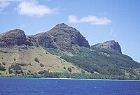
Mount Duff, also called Auorotini in the Mangarevan language, is the highest peak on the island of Mangareva in the Gambier Islands, French Polynesia. It has an elevation of 441 m. The peak was named by James Wilson after the ship Duff, which carried missionaries of the London Missionary Society to Tahiti.

<span class="mw-page-title-main">Maputeoa</span> Monarch of Mangareva and the other Gambier Islands

Te Maputeoa was a monarch of the Polynesian island of Mangareva and the other Gambier Islands. He was the King or ʻAkariki, as well as the penultimate king of the island of Mangareva, and other Gambier Islands including Akamaru, Aukena, Taravai and Temoe. He reigned from 1830 until his death in 1857.

<span class="mw-page-title-main">Joseph Gregorio II</span> King of Mangareva

Joseph Gregorio II was the last King or ʻAkariki of the island of Mangareva, and other Gambier Islands including Akamaru, Aukena, Taravai and Temoe. His short reign lasted from 1857 until his death in 1868. His childless death left the royal succession of Mangareva in doubt.

Maria Eutokia Toaputeitou was Queen consort of the island of Mangareva, and other Gambier Islands including Akamaru, Aukena, Taravai and Temoe. She served as regent for her son in his minority and for a short period afterward in the interregnum period when the royal succession of Mangareva was in doubt.

<span class="mw-page-title-main">Honoré Laval</span>

Honoré Laval, SS.CC., was a French Catholic priest of the Congregation of the Sacred Hearts of Jesus and Mary, a religious institute of the Roman Catholic Church, who evangelized the Gambier Islands.

<span class="mw-page-title-main">Bernardo Putairi</span> Regent of Mangareva

Bernardo Putairi was the Prince Regent of the island of Mangareva, and other Gambier Islands including Akamaru, Aukena, Taravai and Temoe from 1873 to 1881. He served as regent and de facto monarch during the interregnum period when the royal succession of Mangareva was in doubt and after the death of the last royal heir became the last monarch of the island kingdom. His name is often written Putaïri or Putairï in French sources.

Tiripone Mama Taira Putairi, SS.CC., (1846–1881) was educated by French missionaries from birth and became the first indigenous Roman Catholic priest ordained in Eastern Polynesia. He was part of the native royal family of Mangareva, and his father Bernardo Putairi was the island's last ruling regent.

Arone Teikatoara was the penultimate Prince Regent of the island of Mangareva, and other Gambier Islands including Akamaru, Aukena, Taravai and Temoe from 1869 to 1873. He served as regent and de facto monarch during the interregnum period when the royal succession of Mangareva was in doubt. His first name has also been spelled "Arona", "Aarona" or "Aarone".

Akakio Tematereikura was the Prince Regent of the Polynesian island of Mangareva and other territories of the Gambier Islands, including Akamaru, Aukena, Taravai and Temoe, in 1869. He served as regent and de facto monarch during the interregnum period when the royal succession of Mangareva was in doubt. His name is also written as Akakio Matereikura in some French sources.

Undecimal is a positional numeral system that uses eleven as its base. While no known society counts by elevens, two are purported to have done so: the Māori and the Pañgwa. The idea of counting by elevens remains of interest for its relation to a traditional method of tally-counting practiced in Polynesia. During the French Revolution, undecimal was briefly considered as a possible basis for the reformed system of measurement. Undecimal numerals have applications in computer science, technology, and the International Standard Book Number system. They also occasionally feature in works of popular fiction. In undecimal, a capital letter or the digit ↊ is typically used as a transdecimal symbol to represent the number 10.

Karenleigh A. Overmann is a cognitive archaeologist known for her work on how ancient societies became numerate and literate. She currently directs the Center for Cognitive Archaeology at the University of Colorado, Colorado Springs. Before becoming an academic researcher, Overmann served 25 years of active duty in the U.S. Navy.

References

  1. "Population". Institut de la statistique de la Polynésie française. Retrieved 5 October 2014.
  2. Anderson, Atholl; Conte, Eric; Kirch, Patrick V.; Weisler, Marshall (2003). "Cultural chronology in Mangareva (Gambier Islands), French Polynesia: Evidence from recent radiocarbon dating" (PDF). Journal of the Polynesian Society. 112 (2): 137. Retrieved 25 October 2022.
  3. Green, Robert C.; Weisler, Marshall I. (2002). "The Mangarevan Sequence and Dating of the Geographic Expansion into Southeast Polynesia" (PDF). Asian Perspectives. 41 (2): 233. Retrieved 25 October 2022.
  4. Jared Diamond (2005). Collapse: How Societies Choose to Fail or Survive. London: Allen Lane. p. 132.
  5. S. Percy Smith (1918). "Notes on the Mangareva, or Gambier group of islands, eastern Polynesia". Journal of the Polynesian Society. 27 (107): 115. Retrieved 15 December 2021.
  6. Te Rangi Hiroa (1953). Explorers of the Pacific: European and American Discoveries in Polynesia. Honolulu: Bernice P. Bishop Museum. p. 47. Retrieved 25 October 2022 via NZETC.
  7. Gonschor, Lorenz Rudolf (August 2008). Law as a Tool of Oppression and Liberation: Institutional Histories and Perspectives on Political Independence in Hawaiʻi, Tahiti Nui/French Polynesia and Rapa Nui (Thesis). Honolulu: University of Hawaii at Manoa. pp. 56–59. hdl:10125/20375.
  8. "Leaked French documents show impact of nuclear blasts on Mangareva". RNZ. 18 May 2005. Retrieved 25 October 2022.
  9. Vincent Jauvert (5 February 1998). "Essais nucléaires. Les archives interdites de l'armée". Le Nouvel Observateur (in French). p. 10.
  10. "French admit nuclear test fallout hit islands". New Zealand Herald. 4 October 2006. Retrieved 25 October 2022.
  11. "Fiche Climatologique Statistiques 1991-2020 et records" (PDF). Météo-France . Retrieved 26 August 2022.
  12. 1 2 Bender, Andrea; Beller, Sieghard (2013). "Mangarevan invention of binary steps for easier calculation". Proceedings of the National Academy of Sciences USA. 111 (4): 1322–1327. doi: 10.1073/pnas.1309160110 . PMC   3910603 . PMID   24344278.
  13. Rieth, Timothy; Cochrane, Ethan (2018). "The chronology of colonization in remote Oceania". In Cochrane, E.; Hunt, T. (eds.). The Oxford Handbook of Prehistoric Oceania. Oxford University Press. pp. 133–161. ISBN   978-0-199-92507-0.
  14. 1 2 3 Overmann, Karenleigh A. (2020). "The curious idea that Māori once counted by elevens, and the insights it still holds for cross-cultural numerical research". Journal of the Polynesian Society. 129 (1): 59–84. doi: 10.15286/jps.129.1.59-84 . Retrieved 24 July 2020.
  15. Overmann, Karenleigh A. (2023). The Materiality of Numbers: Emergence and Elaboration from Prehistory to Present. Cambridge University Press. ISBN   9781009361248.
  16. 1 2 Overmann, Karenleigh A. (2020). Oceanian counting algorithms: Analytical data for EU project 785793. Unpublished. Retrieved 21 March 2022.
  17. Overmann, Karenleigh A. (2021). "Counting by 'elevens' and why nine and two make twenty: The material roots of Polynesian numbers". Journal of Mathematics and Culture. 15 (3): 1–32. Retrieved 2 November 2021.
  18. Hiroa, Te Rangi (1938). Ethnology of Mangareva. Honolulu, Hawaii: Bernice P. Bishop Museum. p. 417. OCLC   715560748.
  19. Janeau, Vincent-Ferrier (1908). Essai de grammaire de la langue des îles Gambier, ou Mangaréva[Essay on the grammar of the language of the Gambier Islands, or Mangareva] (in French). Braine-le-Comte, Belgium: Zech et Fils. p. 20. OCLC   558858398.
  20. 1 2 Manuireva, Ena (2014). "Mangarevan – A Shifting Language" (PDF). Retrieved 29 September 2018.