The Tuamotu Archipelago or the Tuamotu Islands are a French Polynesian chain of just under 80 islands and atolls in the southern Pacific Ocean. They constitute the largest chain of atolls in the world, extending over an area roughly the size of Western Europe. Their combined land area is 850 square kilometres. This archipelago's major islands are Anaa, Fakarava, Hao and Makemo.

The Tuamotu sandpiper is an endangered member of the large wader family Scolopacidae, that is endemic to the Tuamotu Islands in French Polynesia. It is sometimes placed in the monotypic genus Aechmorhynchus. A native name, apparently in the Tuamotuan language, is kivi-kivi.
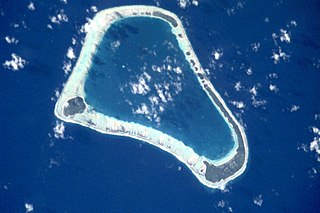
Hao, or Haorangi, is a large coral atoll in the central part of the Tuamotu Archipelago. It has c. 1000 people living on 35 km2 (14 sq mi). It was used to house the military support base for the nuclear tests on Mururoa. Because of its shape, French explorer Louis Antoine de Bougainville named it "Île de la Harpe".
Hereheretue or Hiri-oro is an atoll in French Polynesia, Pacific Ocean. It is the northernmost island of the Duke of Gloucester Islands group, or Îles du Duc de Gloucester, a subgroup of the Tuamotu group. Hereheretue's nearest neighbour is Anuanuraro, which is located about 150 km away. It lies 450 km southwest of Hao and 488 km southeast of Tahiti.

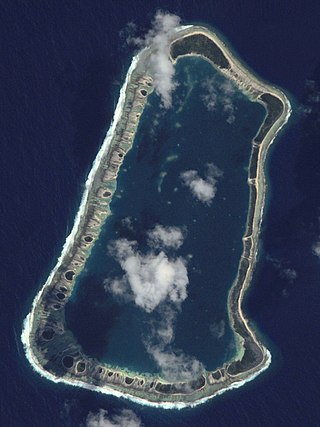
Matureivavao, or Maturei-vavao is an uninhabited atoll in the Acteon Group in the southeastern part of the Tuamotu Islands. It is the largest atoll within the Acteon Group, and like others in this group, is administratively part of the commune of the Gambier Islands.

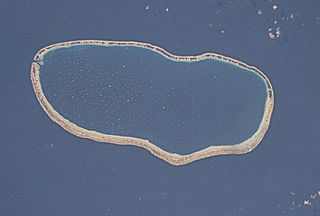
Tenararo is the smallest atoll in the Acteon Group in the southeastern part of the Tuamotu Islands in French Polynesia. It is administratively a part of the Gambier Islands. It is uninhabited.

Vahanga is a small uninhabited atoll part of the Acteon Group in the Tuamotu archipelago, French Polynesia and belongs to the municipality of the Gambier Islands.

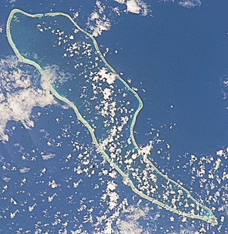
Anaa, Nganaa-nui is an atoll in the Tuamotu archipelago, in French Polynesia. It is located in the north-west of the archipelago, 350 km to the east of Tahiti. It is oval in shape, 29.5 km in length and 6.5 km wide, with a total land area of 38 km2 and a population of 504. The atoll is made up by eleven small barren islands with deeper and more fertile soil than other atolls in the Tuamotus. The lagoon is shallow, without entrance, and formed by three main basins. Although it does not have any navigable access, the water of the lagoon renews by several small channels that can be crossed walking.

Amanu, Timanu, or Karere, is an atoll in the Tuamotu archipelago. Amanu lies at right angles to neighbouring Hao Atoll; this orientation is quite rare for the Tuamotu atolls.

Raroia, or Raro-nuku, is an atoll of the Tuamotus chain in French Polynesia, located 740 km northeast of Tahiti and 6 km southwest of Takume. Administratively it is a part of the commune of Makemo.
Fakarava, Havaiki-te-araro, Havai'i or Farea is an atoll in the west of the Tuamotu group in French Polynesia. It is the second largest of the Tuamotu atolls. The nearest land is Toau, a coral atoll which lies 14 kilometres to the northwest.

Tikehau or Porutu-kai is a coral atoll in the Palliser Islands group, part of the Tuamotu Archipelago in French Polynesia. It is included in the commune of Rangiroa.

Takume or Pukamaru is an atoll of the Tuamotus chain in French Polynesia, located 790 km northeast of Tahiti and 6 km northeast of Raroia and 128 kilometres to the west of Fangatau.
Faaite, or Faaiti is an atoll of the Tuamotus in French Polynesia. It is located 60 kilometres to the north of Anaa Atoll. The total surface of the atoll is 227 square kilometres Its dry land area is 8.87 square kilometres. Its length is 28 kilometres and its width 10.5 kilometres. The total population as of 2012 is 401 inhabitants.
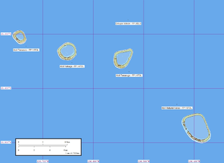
The Acteon Group is a rather isolated and uninhabited subgroup in the far southeast of the Tuamotu atoll group in French Polynesia. It is located about 1,400 km (870 mi) east-southeast of Tahiti at latitude: 21° 17' 60 S, longitude: 136° 29' W.

Vairaatea is a small atoll of the Tuamotu group in French Polynesia. Geographically Vairaatea Atoll is part of the East-central subgroup of the Tuamotus, which includes Ahunui, Amanu, Fangatau, Hao and Nukutavake. Nukutavake, the closest land, lies 41 kilometres to the east.

Marutea Atoll, also known as Lord Hood Island, Marutea-i-runga, and Nuku-nui, is an atoll in the far southeast of the Tuamotu group of French Polynesia. It lies in the east-northeast part of the Gambier (commune), about 72 km northeast from Maria Atoll.

Tauere Atoll or Taouere, also known as Te Putua, is a small atoll of the central Tuamotu Archipelago in French Polynesia. It is located 85 kilometres northwest of Hao Atoll's westernmost point.

Anuanuraro is an atoll in French Polynesia, Pacific Ocean. It is part of the Duke of Gloucester Islands, a subgroup of the Tuamotu group. Anuanuraro's nearest neighbor is Anuanurunga, which is located about 29 km to the southeast.
Temoe, or Te Moe, is a small atoll of the Gambier Islands in French Polynesia. It is located in the far southeast of the Tuamotu group archipelago. It lies about 37 km southeast from the Gambier Islands and more than 1,700 kilometres southeast from Mataiva, at the other end of the Tuamotu archipelago.


