The Tuamotu Archipelago or the Tuamotu Islands, are a French Polynesian chain of just under 80 islands and atolls in the southern Pacific Ocean. They constitute the largest chain of atolls in the world, extending over an area roughly the size of Western Europe. Their combined land area is 850 square kilometres. This archipelago’s major islands are Anaa, Fakarava, Hao and Makemo.

The Disappointment Islands are a subgroup of the Tuamotu Archipelago in French Polynesia. They are located towards the northeast, away from the main Tuamotu group.

Tepoto, also known as Te Poto, Toho, or Pukapoto, is a coral island. It is the northwesternmost of the Disappointment Islands, in the Tuamotu Archipelago. Despite being often referred to as "atoll", Tepoto is not a typical Tuamotu atoll, but a single separate island without a lagoon. It is located at the limit of the Tuamotu archipelago; the closest land is Napuka, which lies 16 kilometres to the southeast.

Tenararo is the smallest atoll in the Acteon Group in the southeastern part of the Tuamotu Islands in French Polynesia. It is administratively a part of the Gambier Islands. It is uninhabited.

Makatea, or Mangaia-te-vai-tamae, is a raised coral atoll in the northwestern part of the Tuamotus, which is a part of the French overseas collectivity of French Polynesia. It is located 79 kilometres (49 mi) southwest from Rangiroa to the west of the Palliser group, which also is in French Polynesia. Makatea is surrounded by spectacular cliffs, rising to a plateau 80 metres (260 ft) above sea level. This island is 7.5 kilometres (4.7 mi) long, with a maximum width of 7 kilometres (4.3 mi) in the south. It is 24 square kilometres (9.3 sq mi) in area. Makatea is one of the only four islands of the Tuamotu Archipelago that do not take the form of a typical atoll.

Makemo, Rangi-kemo or Te Paritua, is an atoll in the Tuamotu archipelago in French Polynesia.

The Polynesian ground dove is a critically endangered species of bird in the family Columbidae. It is endemic to the Tuamotus in French Polynesia with recent records from the atolls of Matureivavao, Rangiroa, Tenararo, Morane, Vahanga and perhaps Tikehau. It favors tropical forests, especially with Pandanus tectorius, Pisonia grandis and shrubs, but it has also been recorded from dense shrub growing below coconut palms. It is threatened by habitat loss and predation by introduced species such as cats and rats. The total population is estimated to be around 100-120 birds and it has already disappeared from several islands where it formerly occurred.

Tikehau or Porutu-kai is a coral atoll in the Palliser Islands group, part of the Tuamotu Archipelago in French Polynesia. It is included in the commune of Rangiroa.

Takume or Pukamaru is an atoll of the Tuamotus chain in French Polynesia, located 790 km northeast of Tahiti and 6 km northeast of Raroia and 128 kilometres to the west of Fangatau.
The Raeffsky Islands or Raevski Islands is a subgroup with just over 3000 people in the Tuamotu group in French Polynesia. They are located roughly in the central area of the main Tuamotu atoll cluster. Named after Nikolay Raevsky, a Russian general of the Napoleonic wars.

Marutea, or Taunga tauranga-e-havana, is one of the Tuamotu atolls in French Polynesia. It is located 24 km to the southeast of Makemo Atoll and 30 km southwest of Nihiru Atoll.

Nihiru, or Nikia, is one of the Tuamotu atolls in French Polynesia. It is a relatively small atoll located 49 km to the east of Makemo Atoll and 30 km northeast of Marutea Atoll.
Taenga, or Taunga-hara, is one of the Tuamotu atolls in French Polynesia. It is located 32 km to the northeast of Makemo Atoll and 27 km to the northwest of Nihiru Atoll.

Vairaatea is a small atoll of the Tuamotu group in French Polynesia. Geographically Vairaatea Atoll is part of the East-central subgroup of the Tuamotus, which includes Ahunui, Amanu, Fangatau, Hao and Nukutavake. Nukutavake, the closest land, lies 41 kilometres to the east.

Haraiki is a small atoll of the Tuamotu Archipelago in French Polynesia. It is located 42 km southwest of Marutea Nord.

Hiti, or Hiti-rau-mea, is a small atoll of the Tuamotu Archipelago in French Polynesia. It is located 19 km southwest of Makemo Atoll.

Tuanake or Mata-rua-puna is a small atoll located in the Tuamotu Archipelago in French Polynesia. He made up the Raevski Islands subgroup with Tepoto Sud and Hiti. It is administratively attached to the municipality of Makemo.

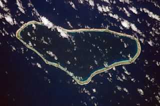
Katiu, or Taungataki, is an atoll of the central Tuamotu Archipelago in French Polynesia. It is located 23.5 kilometres west of Makemo Atoll's westernmost point. It measures 27 kilometres in length with a maximum width of 12.5 kilometres. Its total area, including the lagoon is 232.5 square kilometres and a land area of approximately 10 square kilometres. There are many narrow islands on the north-eastern side of its long reef with a total land area of about 3 square kilometres. Its lagoon is connected to the ocean.

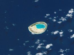
Morane is an uninhabited small isolated atoll of the Tuamotu Archipelago in French Polynesia. It is located 153 km southwest of Maria Est, its closest neighbour. Morane Atoll is the southernmost atoll of the Tuamotus proper. It measures 5.8 km in length, 3.5 km in width and has a land area of 2.85 km2. The lagoon has an area of 11 km2 and has no passes. The islands on its reef are covered with screw pine (Pandanus) and coconut trees.

The Tuamotu tropical moist forests is a tropical and subtropical moist broadleaf forests ecoregion in the Tuamotu Archipelago of French Polynesia and the Pitcairn Islands.