Monks Mound

Last updated

Monks Mound
Monks Mound in July.JPG
Monks Mound in summer. The concrete staircase follows the approximate course of the ancient wooden stairs
USA Illinois location map.svg
Archaeological site icon (red).svg
Location within Illinois today
Location Collinsville, Illinois,  Madison County, Illinois, United States
Region Madison County, Illinois
Coordinates 38°39′38.4″N90°3′43.36″W / 38.660667°N 90.0620444°W / 38.660667; -90.0620444
History
Founded900–950 CE
Cultures Mississippian culture
Site notes
Archaeologists Thomas I. Ramey
Architecture
Architectural styles Platform mound
Responsible body: Illinois Historic Preservation Agency

Monks Mound is the largest Pre-Columbian earthwork in the Americas and the largest pyramid north of Mesoamerica. The beginning of its construction dates from 900 to 955 CE. Located at the Cahokia Mounds UNESCO World Heritage Site near Collinsville, Illinois, the mound size was calculated in 1988 as about 100 feet (30 m) high, 955 feet (291 m) long including the access ramp at the southern end, and 775 feet (236 m) wide. [1] This makes Monks Mound roughly the same size at its base as the Great Pyramid of Giza (13.1 acres / 5.3 hectares). The perimeter of its base is larger than the Pyramid of the Sun at Teotihuacan. As a platform mound, the earthwork supported a wooden structure on the summit.

Contents

Unlike Egyptian pyramids which were built of stone, the platform mound was constructed almost entirely of layers of basket-transported soil and clay. Because of this construction and its flattened top, over the years, it has retained rainwater within the structure. This has caused slumping, the avalanche-like sliding of large sections of the sides at the highest part of the mound. Its designed dimensions would have been significantly smaller than its present extent, but recent excavations have revealed that slumping was a problem even while the mound was being made. [2]

Construction and abandonment

Monks Mound from the side showing the 2 terraces. Cahokia monks mound HRoe 2008.jpg
Monks Mound from the side showing the 2 terraces.

Construction of Monks Mound by the Mississippian culture began about 900–950 CE, on a site that had already been occupied by buildings. The original concept seems to have been a much smaller mound, now buried deep within the northern end of the present structure. At the northern end of the summit plateau, as finally completed around 1100 CE, is an area raised slightly higher still, on which was placed a building over 100 ft (30 m) long, the largest in the entire Cahokia Mounds urban zone. Excavations on the southwest corner found that several large ceremonial buildings had burned around 1150 CE. [3]

Botanical remains from Monks Mound suggest it was built much more quickly than previously thought, perhaps on the order of several consecutive decades, providing an alternative view of its construction history. [4] Deep excavations in 2007 confirmed findings from earlier test borings, that several types of earth and clay from different sources had been used successively. [2] Study of various sites suggests that the stability of the mound was improved by the incorporation of bulwarks, some made of clay, others of sods from the Mississippi flood-plain, which permitted steeper slopes than the use of earth alone. [5] The structure rises in four terraces to a height of 100 feet (30 m) with a rectangular base covering nearly 15 acres (6.1 ha) and containing 22 million cubic feet of adobe, carried basket by basket to the site. [6]

The most recent section of the mound, added some time before 1200 CE, is the lower terrace at the south end, which was added after the northern end had reached its full height. It may partly have been intended to help minimize the slumping which by then was already under way. Today, the western half of the summit plateau is significantly lower than the eastern; this is the result of massive slumping, beginning about 1200 CE. [7] This also caused the west end of the big building to collapse. It may have led to the abandonment of the mound's high status, following which various wooden buildings were erected on the south terrace, and garbage was dumped at the foot of the mound. By about 1300, the urban society at Cahokia Mounds was in serious decline. When the eastern side of the mound started to suffer serious slumping, it was not repaired. [8]

European settlers

There is no evidence of significant Native American settlement in the Cahokia Mounds urban area for hundreds of years after about 1400 CE. In 1735, French missionaries built a chapel at the west end of the south terrace of the mound. The River L'Abbe Mission served a small Illiniwek community, until they were forced to abandon the area by rival tribes about 1752. In 1776, during the American Revolutionary War, a trading post called the Cantine was established next to the mound (by then known as the Great Nobb). It lasted only until 1784.

In the early 19th century, the land was claimed by people of French descent, and Nicholas Jarrot had a deed for most of it. He donated some to a small group of French Trappist monks, who settled on one of the smaller mounds from 1809. They took advantage of the big mound's terraces to grow produce, which was elevated above the danger of flooding: wheat on the upper levels, garden produce on the south terrace. During their short stay in the area, which lasted until 1813, Henry Brackenridge visited the site and published the first detailed description of the largest mound. He named it Monks Mound.

In 1831 T. Amos Hill bought the plot including the Mound. He built a house on the upper terrace, and sank a well. This work revealed various archaeological remains, including human bones. [9]

Archaeology

Looking over the Cahokia Mounds site from the top of Monks Mound Atop-monks-mound.JPG
Looking over the Cahokia Mounds site from the top of Monks Mound

Thomas I. Ramey, who bought the site in 1864, began an era of more responsible ownership, and encouraged archaeological investigation. Many artifacts were found at or near the surface. Ramey had a tunnel made nearly 30 m (98 ft) into the north face of the mound, but it revealed nothing of historic interest. By this time, people were beginning to consider the mound more within its context. A survey made for local dentist Dr. John R. Patrick in the 1880s marked the beginning of modern understanding of the Cahokia site as a whole, and its relationship to other sites in the area. [9]

Many archaeological investigations of the mound have taken place since then. One of the biggest began in the 1960s, when Nelson Reed, a local businessman and historian of native cultures, obtained permission to conduct excavations. He was trying to locate the high-status building (temple or palace) presumed to have stood at the peak of Monks Mound. By drilling cores at various points on the mound, his team revealed the various stages of its construction from the 10th to 12th centuries CE. Remains of a fairly recent house (presumably Hill's) were found, but no temple.

In 1970 Reed returned to work at the mound, and adopted a new strategy: scraping away the topsoil from several 5 m2 (54 sq ft) patches with a backhoe, to a depth of around 60 cm (24 in). This quickly revealed various features, including what appeared to be the outline of the temple. Further backhoe work in 1971 confirmed the shape of the presumed temple at over 30 m (98 ft) long, the largest building found at Cahokia. This technique was opposed by professional archaeologists because it destroyed several hundred years of stratification over most of the mound's summit, which was the evidence by which they could place and evaluate artifacts and construction. Reed's backhoe excavations revealed other significant features, such as a hole which seemed to have been the socket for a post about three feet (one metre) in diameter. The dramatic finds encouraged the Governor of Illinois to budget for an expansion of the Cahokia Mounds State Park. [10]

Preservation

From the time the original urban society collapsed, the great mound became overgrown with trees, the roots of which helped stabilize its steep slopes. In the 20th century, researchers removed the trees in the course of work at the mound and park preparation. Reduction of groundwater levels in the Mississippi floodplain during the 1950s caused the mound to dry out, damaging the clay layers within. When heavy rainfall occurred, it caused new slumping, starting about 1956. The increasingly violent weather of recent decades has exacerbated the problem. [11] In 1984-5 there were several slumps, and the state government brought in surplus soil to make repairs to the major scar on the eastern side. A decade later, there was further slumping on the western side, so irregular that repair was impractical. Drains were installed to reduce the effects of heavy rain. It was during this process that workers discovered a mass of stone deep within the mound.

The repairs of the 1980s and 1990s were only partly successful. In 2004-5 more serious slumping episodes occurred. These demonstrated that adding new earth to repair the major slump on the east side had been a mistake. Experts decided to take a new approach. In 2007, backhoes were used to dig out the entire mass of earth from this slump and another at the northwest corner, to a level beyond the internal slippage zone. Engineers created a series of anti-slip "steps" across the exposed face before the original earth (minus the imported repair material) was replaced at its original level. To avoid introducing water deep into the mound's interior, the work was carried out in high summer, and as quickly as possible. In parallel with the repair work, teams of archaeologists studied the evidence that was being revealed. [2] The eastern sliding zone penetrated more deeply within the mound than originally estimated, and the excavation had to be very large- [12] 50 feet (15 m) wide, to a height of 65 feet (20 m) above the mound base. [2] This heightened concerns about a conflict between conservation and archaeology.

See also

Related Research Articles

<span class="mw-page-title-main">Cahokia</span> Archaeological site near East St. Louis, Illinois, USA

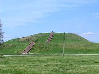
The Cahokia Mounds State Historic Site is the site of a pre-Columbian Native American city directly across the Mississippi River from present-day St. Louis, Missouri. This historic park lies in south-western Illinois between East St. Louis and Collinsville. The park covers 2,200 acres (890 ha), or about 3.5 square miles (9 km2), and contains about 80 manmade mounds, but the ancient city was much larger. At its apex around 1100 CE, the city covered about 6 square miles (16 km2), included about 120 earthworks in a wide range of sizes, shapes, and functions, and had a population of between 15,000 and 20,000 people.

<span class="mw-page-title-main">Etowah Indian Mounds</span> Archaeological site in Georgia, U.S.

Etowah Indian Mounds (9BR1) are a 54-acre (220,000 m2) archaeological site in Bartow County, Georgia, south of Cartersville. Built and occupied in three phases, from 1000–1550 CE, the prehistoric site is located on the north shore of the Etowah River.

<span class="mw-page-title-main">Angel Mounds</span> United States historic place

Angel Mounds State Historic Site, an expression of the Mississippian culture, is an archaeological site managed by the Indiana State Museum and Historic Sites that includes more than 600 acres of land about 8 miles (13 km) southeast of present-day Evansville, in Vanderburgh and Warrick counties in Indiana. The large residential and agricultural community was constructed and inhabited from AD 1100 to AD 1450, and served as the political, cultural, and economic center of the Angel chiefdom. It extended within 120 miles (190 km) of the Ohio River valley to the Green River in present-day Kentucky. The town had as many as 1,000 inhabitants inside the walls at its peak, and included a complex of thirteen earthen mounds, hundreds of home sites, a palisade (stockade), and other structures.

<span class="mw-page-title-main">Mississippian culture</span> Native American culture in the United States (800 - 1600)

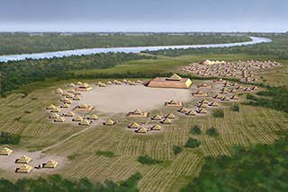
The Mississippian culture was a Native American civilization that flourished in what is now the Midwestern, Eastern, and Southeastern United States from approximately 800 to 1600, varying regionally. It was known for building large, earthen platform mounds, and often other shaped mounds as well. It was composed of a series of urban settlements and satellite villages linked together by loose trading networks. The largest city was Cahokia, believed to be a major religious center located in what is present-day southern Illinois.

<span class="mw-page-title-main">Mound Builders</span> Pre-Columbian cultures of North America

Many pre-Columbian cultures in North America were collectively termed "Mound Builders", but the term has no formal meaning. It does not refer to specific people or archaeological culture but refers to the characteristic mound earthworks that indigenous peoples erected for an extended period of more than 5,000 years. The "Mound Builder" cultures span the period of roughly 3500 BCE to the 16th century CE, including the Archaic period, Woodland period, and Mississippian period. Geographically, the cultures were present in the region of the Great Lakes, the Ohio River Valley, Florida, and the Mississippi River Valley and its tributary waters.

<span class="mw-page-title-main">American Bottom</span> Flood plain of the Mississippi River in Illinois

The American Bottom is the flood plain of the Mississippi River in the Metro East region of Southern Illinois, extending from Alton, Illinois, south to the Kaskaskia River. It is also sometimes called "American Bottoms". The area is about 175 square miles (450 km2), mostly protected from flooding in the 21st century by a levee and drainage canal system. Immediately across the river from St. Louis, Missouri, are industrial and urban areas, but nearby marshland, swamps, and the Horseshoe Lake are reminders of the Bottoms' riparian nature.

<span class="mw-page-title-main">Shiloh Indian Mounds Site</span> United States historic place

Shiloh Indian Mounds Site (40HR7) is an archaeological site of the South Appalachian Mississippian culture. It is located beside the Tennessee River on the grounds of the Shiloh National Military Park, in Hardin County of southwestern Tennessee. A National Historic Landmark, it is one of the largest Woodland era sites in the southeastern United States.

<span class="mw-page-title-main">Platform mound</span> Earthwork or mound intended to support a structure or activity

A platform mound is any earthwork or mound intended to support a structure or activity. It typically refers to a flat-topped mound, whose sides may be pyramidal.

<span class="mw-page-title-main">Spiro Mounds</span> Precontact Indigenous ceremonial site in Oklahoma

Spiro Mounds is an Indigenous archaeological site located in present-day eastern Oklahoma. The site was built by people from the Arkansas Valley Caddoan culture. that remains from an American Indian culture that was part of the major northern Caddoan Mississippian culture. The 80-acre site is located within a floodplain on the southern side of the Arkansas River. The modern town of Spiro developed approximately seven miles to the south.

<span class="mw-page-title-main">Dickson Mounds</span> Native American historical site in Illinois, U.S.

Dickson Mounds is a Native American settlement site and burial mound complex near Lewistown, Illinois. It is located in Fulton County on a low bluff overlooking the Illinois River. It is a large burial complex containing at least two cemeteries, ten superimposed burial mounds, and a platform mound. The Dickson Mounds site was founded by 800 CE and was in use until after 1250 CE. The site is named in honor of chiropractor Don Dickson, who began excavating it in 1927 and opened a private museum that formerly operated on the site. Its exhibition of the 237 uncovered skeletons uncovered and displayed by Dickson was closed in 1992 by then-Gov. Jim Edgar.

<span class="mw-page-title-main">Town Creek Indian Mound</span> National Historic Landmark in North Carolina

Town Creek Indian Mound is a prehistoric Native American archaeological site located near present-day Mount Gilead, Montgomery County, North Carolina, in the United States. The site, whose main features are a platform mound with a surrounding village and wooden defensive palisade, was built by the Pee Dee, a South Appalachian Mississippian culture people that developed in the region as early as 980 CE. They thrived in the Pee Dee River region of North and South Carolina during the Pre-Columbian era. The Town Creek site was an important ceremonial site occupied from about 1150—1400 CE. It was abandoned for unknown reasons. It is the only ceremonial mound and village center of the Pee Dee located within North Carolina.

<span class="mw-page-title-main">Kincaid Mounds State Historic Site</span> Archaeological site in Illinois, US

The Kincaid Mounds Historic Site c. 1050–1400 CE, is a Mississippian culture archaeological site located at the southern tip of present-day U.S. state of Illinois, along the Ohio River. Kincaid Mounds has been notable for both its significant role in native North American prehistory and for the central role the site has played in the development of modern archaeological techniques. The site had at least 11 substructure platform mounds, and 8 other monuments.

<span class="mw-page-title-main">Albany Mounds State Historic Site</span> United States historic place

Albany Mounds State Historic Site, also known as Albany Mounds Site, is a historic site operated by the Illinois Historic Preservation Agency. It spans over 205 acres of land near the Mississippi river at the northwest edge of the state of Illinois in the United States. In 1974, the site was added to the National Register of Historic Places list. The historical site is under the provision of the Illinois Historic Preservation Agency, a governmental agency founded in 1985 for the maintaining of historical sites within the state. In the 1990s, the site underwent a restoration project that aimed to return its appearance to its original condition.

<span class="mw-page-title-main">Emerald Mound site</span> United States historic place

The Emerald Mound site, also known as the Selsertown site, is a Plaquemine culture Mississippian period archaeological site located on the Natchez Trace Parkway near Stanton, Mississippi, United States. The site dates from the period between 1200 and 1730 CE. It is the type site for the Emerald Phase of the Natchez Bluffs Plaquemine culture chronology and was still in use by the later historic Natchez people for their main ceremonial center. The platform mound is the second-largest Mississippian period earthwork in the country, after Monk's Mound at Cahokia, Illinois.

<span class="mw-page-title-main">Mississippian copper plates</span>

Mississippian copper plates, or plaques, are plain and repousséd plates of beaten copper crafted by peoples of the various regional expressions of the Mississippian culture between 800 and 1600 CE. They have been found as artifacts in archaeological sites in the American Midwest and Southeast. The plates, found as far afield as Florida, Georgia, Illinois, Mississippi, Oklahoma, Tennessee, and Wisconsin, were instrumental in the development of the archaeological concept known as the Southeastern Ceremonial Complex. Some of the more notable examples are representations of raptorial birds and avian-themed dancing warriors.

Mound 34 is a small platform mound located roughly 400 metres (1,300 ft) to the east of Monks Mound at Cahokia Mounds near Collinsville, Illinois. Excavations near Mound 34 from 2002 to 2010 revealed the remains of a copper workshop, although the one of a kind discovery had been previously found in the late 1950s by archaeologist Gregory Perino, but lost for 60 years. It is so far the only remains of a copper workshop found at a Mississippian culture archaeological site.

<span class="mw-page-title-main">Mound 72</span> Small ridgetop Mississippian mound near Collinsville, Illinois

Mound 72 is a small ridgetop mound located roughly 850 meters (2,790 ft) to the south of Monks Mound at Cahokia Mounds near Collinsville, Illinois. Early in the site's history, the location began as a circle of 48 large wooden posts known as a "woodhenge". The woodhenge was later dismantled and a series of mortuary houses, platform mounds, mass burials and eventually the ridgetop mound erected in its place. The mound was the location of the "beaded burial", an elaborate burial of an elite personage thought to have been one of the rulers of Cahokia, accompanied by the graves of several hundred retainers and sacrificial victims.

<span class="mw-page-title-main">Cahokia Woodhenge</span> Series of large timber circles at the Mississippian culture Cahokia archaeologial site, US

The Cahokia Woodhenge was a series of large timber circles located roughly 850 metres (2,790 ft) to the west of Monks Mound at the Mississippian culture Cahokia archaeological site near Collinsville, Illinois, United States. They are thought to have been constructed between 900 and 1100 CE; with each one being larger and having more posts than its predecessor. The site was discovered as part of salvage archaeology in the early 1960s interstate highway construction boom, and one of the circles was reconstructed in the 1980s. The circle has been used to investigate archaeoastronomy at Cahokia. Annual equinox and solstice sunrise observation events are held at the site.

<span class="mw-page-title-main">Emerald Mound and Village Site</span> Archaeological site in Illinois, United States

The Emerald Mound and Village Site is a pre-Columbian archaeological site located northwest of the junction of Emerald Mound Grange and Midgley Neiss Roads in St. Clair County, Illinois. The site includes five mounds, two of which have been destroyed by modern activity, and the remains of a village. Middle Mississippian peoples inhabited the village, which was a satellite village of Cahokia. The largest of the mounds is a two-tiered structure that stands 50 feet (15 m) high; its square base is 300 feet (91 m) across, while its upper tier is 150 feet (46 m) across. At the time of its discovery, the mound was the second-largest known in Illinois after Monks Mound at Cahokia.

The Carson Mounds, also known as the Carson Site and Carson-Montgomery- is a large Mississippian culture archaeological site located near Clarksdale in Coahoma County, Mississippi, in the Yazoo Basin. Only a few large earthen mounds are still present at Carson to this day. Archaeologists have suggested that Carson is one of the more important archaeological sites in the state of Mississippi.

References

  1. Skele, Mike "The Great Knob", Studies in Illinois Archaeology, no. 4], Springfield, IL, Illinois Historic Preservation Agency (1988) ISBN   0942579038, pp. 1–3, via archive.org
  2. 1 2 3 4 Iseminger, Bill et al. "Monks Mound (Mound 38) Projects 1997 – 2007 Archived 2005-01-08 at archive.today , from The Cahokian (various issues 1998–2007)- at cahokiamounds.com
  3. Visitor's explanatory signpost, posted atop the Monks Mound by the Cahokia Mounds State Historic Site. For a photograph of the signpost, see minutes 3:28 in Cahokia Field Trip: The Mississippian Culture's First City on YouTube
  4. Lopinot, Neal H.; Schilling, Timothy; Fritz, Gayle J.; Kelly, John E. (2015-05-19). "Implications of Plant Remains from the East Face of Monks Mound". Midcontinental Journal of Archaeology. 40 (3): 209–230. doi:10.1179/2327427115y.0000000003. ISSN   0146-1109. S2CID   131309970.
  5. S.C. Sherwood; Tristram .R. Kidder (March 2011). "The DaVincis of Dirt". Journal of Anthropological Archaeology . 30 (1): 69–87. doi:10.1016/j.jaa.2010.11.001.
  6. Nash, Gary B. Red, White and Black: The Peoples of Early North America Los Angeles 2015. Chapter 1, p. 6
  7. Rose, Mark (Jan–Feb 1999). "Sampling Monks Mound". Archaeology . 52 (1).
  8. Young, Biloine W.; Fowler, Melvin L. (2000). Cahokia, the Great Native American Metropolis. Urbana, Illinois: University of Illinois Press. pp. 171–2. ISBN   0-252-06821-1.
  9. 1 2 John A. Walthall & Elizabeth D. Benchley, "The River L'Abbé Mission: A French Colonial Church for the Cahokia Illini on Monks Mound", Studies in Illinois Archaeology, No. 2, Springfield, IL: Historic Preservation Agency (1987), via archive.org
  10. Young & Fowler, pp. 154–7
  11. Skele, p98
  12. Bostrom, Peter A. Mound repair: Cahokia Mounds (31 Jul 2007)- summary with photos

Further reading