Jet streams are fast flowing, narrow, meandering air currents in the atmospheres of some planets, including Earth. On Earth, the main jet streams are located near the altitude of the tropopause and are westerly winds. Jet streams may start, stop, split into two or more parts, combine into one stream, or flow in various directions including opposite to the direction of the remainder of the jet.

Siberia is an extensive geographical region, constituting all of North Asia, from the Ural Mountains in the west to the Pacific Ocean in the east. It has been a part of Russia since the latter half of the 16th century, after the Russians conquered lands east of the Ural Mountains. Siberia is vast and sparsely populated, covering an area of over 13.1 million square kilometres (5,100,000 sq mi), but home to merely one-fifth of Russia's population. Novosibirsk and Omsk are the largest cities in the region.

Winter is the coldest season of the year in polar and temperate climates. It occurs after autumn and before spring. The tilt of Earth's axis causes seasons; winter occurs when a hemisphere is oriented away from the Sun. Different cultures define different dates as the start of winter, and some use a definition based on weather.

In meteorology, an air mass is a volume of air defined by its temperature and water vapor content. Air masses cover many hundreds or thousands of miles, and adapt to the characteristics of the surface below them. They are classified according to latitude and their continental or maritime source regions. Colder air masses are termed polar or arctic, while warmer air masses are deemed tropical. Continental and superior air masses are dry while maritime and monsoon air masses are moist. Weather fronts separate air masses with different density characteristics. Once an air mass moves away from its source region, underlying vegetation and water bodies can quickly modify its character. Classification schemes tackle an air mass' characteristics, as well as modification.

A high-pressure area, high, or anticyclone, is a region where the atmospheric pressure at the surface of the planet is greater than its surrounding environment.

Pelmeni are dumplings of Russian cuisine that consist of a filling wrapped in thin, unleavened dough.
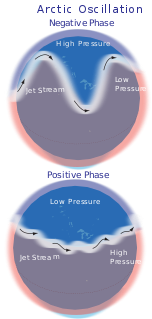
The Arctic oscillation (AO) or Northern Annular Mode/Northern Hemisphere Annular Mode (NAM) is a weather phenomenon at the Arctic pole north of 20 degrees latitude. It is an important mode of climate variability for the Northern Hemisphere. The southern hemisphere analogue is called the Antarctic oscillation or Southern Annular Mode (SAM). The index varies over time with no particular periodicity, and is characterized by non-seasonal sea-level pressure anomalies of one sign in the Arctic, balanced by anomalies of opposite sign centered at about 37–45° N.
The Siberian High (also Siberian Anticyclone; Russian: Азиатский антициклон is a massive collection of cold dry air that accumulates in the northeastern part of Eurasia from September until April. It is usually centered on Lake Baikal. It reaches its greatest size and strength in the winter when the air temperature near the center of the high-pressure area is often lower than −40 °C. The atmospheric pressure is often above 1,040 millibars. The Siberian High is the strongest semi-permanent high in the northern hemisphere and is responsible for both the lowest temperature in the Northern Hemisphere, of −67.8 °C on 15 January 1885 at Verkhoyansk, and the highest pressure, 1083.8 mbar at Agata, Krasnoyarsk Krai on 31 December 1968, ever recorded. The Siberian High is responsible both for severe winter cold and attendant dry conditions with little snow and few or no glaciers across Siberia, Mongolia, and China. During the summer, the Siberian High is largely replaced by the Asiatic low.

A circumpolar vortex, or simply polar vortex, is a large region of cold, rotating air that encircles both of Earth's polar regions. Polar vortices also exist on other rotating, low-obliquity planetary bodies. The term polar vortex can be used to describe two distinct phenomena; the stratospheric polar vortex, and the tropospheric polar vortex. The stratospheric and tropospheric polar vortices both rotate in the direction of the Earth's spin, but they are distinct phenomena that have different sizes, structures, seasonal cycles, and impacts on weather.

Bennett Island is the largest of the De Long Islands in the northern part of the East Siberian Sea. The area of this island is approximately 150 square kilometres and it has a tombolo at its eastern end. The highest point of the island is 426 metres high Mount De Long, the highest point of the archipelago. Bennett Island is part of the Yakutia administrative division of Russia.

A mesoscale convective system (MCS) is a complex of thunderstorms that becomes organized on a scale larger than the individual thunderstorms but smaller than extratropical cyclones, and normally persists for several hours or more. A mesoscale convective system's overall cloud and precipitation pattern may be round or linear in shape, and include weather systems such as tropical cyclones, squall lines, lake-effect snow events, polar lows, and mesoscale convective complexes (MCCs), and generally forms near weather fronts. The type that forms during the warm season over land has been noted across North and South America, Europe, and Asia, with a maximum in activity noted during the late afternoon and evening hours.

Blocks in meteorology are large-scale patterns in the atmospheric pressure field that are nearly stationary, effectively "blocking" or redirecting migratory cyclones. They are also known as blocking highs or blocking anticyclones. These blocks can remain in place for several days or even weeks, causing the areas affected by them to have the same kind of weather for an extended period of time. In the Northern Hemisphere, extended blocking occurs most frequently in the spring over the eastern Pacific and Atlantic Oceans. Whilst these events are linked to the occurrence of extreme weather events such as heat waves, particularly the onset and decay of these events is still not well captured in numerical weather forecasts and remains an open area of research.

A cold wave is a weather phenomenon that is distinguished by a cooling of the air. Specifically, as used by the U.S. National Weather Service, a cold wave is a rapid fall in temperature within a 24-hour period requiring substantially increased protection to agriculture, industry, commerce, and social activities. The precise criteria for a cold wave are the rate at which the temperature falls, and the minimum to which it falls. This minimum temperature is dependent on the geographical region and time of year.

The climate of the United States varies due to changes in latitude, and a range of geographic features, including mountains and deserts. Generally, on the mainland, the climate of the U.S. becomes warmer the further south one travels, and drier the further west, until one reaches the West Coast.

The 1985 North America cold wave was a meteorological event, the result of the shifting of the polar vortex farther south than is normally seen. Blocked from its normal movement, polar air from the north pushed into nearly every section of the central and eastern half of the United States and Canada, shattering record lows in a number of areas. The event was preceded by unusually warm weather in the eastern U.S. in December 1984, suggesting that there was a build-up of cold air that was suddenly released from the Arctic, a meteorological event known as a mobile polar high, a weather process identified by Professor Marcel Leroux.

The early 2014 North American cold wave was an extreme weather event that extended through the late winter months of the 2013–2014 winter season, and was also part of an unusually cold winter affecting parts of Canada and parts of the north-central and upper eastern United States. The event occurred in early 2014 and was caused by a southward shift of the North Polar Vortex. Record-low temperatures also extended well into March.

The November 2014 North American cold wave was an extreme weather event that occurred across most of Canada and the contiguous United States, including parts of the Western United States up to western California. One of the first events of the winter, the cold wave was caused by the northward movement of an extremely powerful bomb cyclone associated with Typhoon Nuri's remnant, which shifted the jet stream far northward, creating an omega block pattern. This allowed a piece of the polar vortex to advance southward into the Central and Eastern United States, bringing record-cold temperatures to much of the region. In contrast, Alaska experienced above-average temperatures.

The 2010–11 North American winter was influenced by an ongoing La Niña, seeing winter storms and very cold temperatures affect a large portion of the continental United States, even as far south as the Texas Panhandle. Notable events included a major blizzard that struck the Northeastern United States in late December with up to 2 feet (24 in) of snowfall and a significant tornado outbreak on New Year's Eve in the southern United States. By far the most notable event was a historic blizzard that impacted areas from Oklahoma to Michigan in early February which broke numerous snowfall records, and one of the few winter storms to rank as a Category 5 on the Regional Snowfall Index.

The 2019–20 North American winter was unusually warm for many parts of the United States; in many areas, neutral ENSO conditions controlled the weather patterns, resulting in the sixth-warmest winter on record, and many areas in the Northeast saw one of the least snowiest winters in years. Some notable events still occurred, such as a powerful blizzard that impacted the Western United States in late November, a series of cold shots in January and February, a snowstorm within the Texas Panhandle and a late-season blizzard in the High Plains.

From June 2021, the taiga forests in Siberia and the Far East region of Russia were hit by unprecedented wildfires, following record-breaking heat and drought. For the first time in recorded history, wildfire smoke reached the North Pole.