West Simsbury, Connecticut

Last updated

West Simsbury, Connecticut
Flamig Farm eggs sign.JPG
Eggs sign at Flamig Farm in West Simsbury
USA Connecticut location map.svg
Red pog.svg
West Simsbury
Usa edcp location map.svg
Red pog.svg
West Simsbury
Coordinates: 41°52′23″N72°51′29″W / 41.87306°N 72.85806°W / 41.87306; -72.85806
CountryUnited States
State Connecticut
County Hartford
Town Simsbury
Area
  Total4.4 sq mi (11.3 km2)
  Land4.4 sq mi (11.3 km2)
  Water0.0 sq mi (0.0 km2)
Elevation
323 ft (98 m)
Population
 (2010)
  Total2,447
  Density563/sq mi (217.2/km2)
Time zone UTC-5 (Eastern)
  Summer (DST) UTC-4 (Eastern)
ZIP code
06092
Area code 860
FIPS code 09-83990
GNIS feature ID2377881

West Simsbury is a census-designated place (CDP) and section of the town of Simsbury in Hartford County, Connecticut, United States. The population of the CDP was 2,447 at the 2010 census. [1]

Contents

Geography

West Simsbury occupies the west-central part of the town of Simsbury and is bordered to the east by Simsbury Center and to the south by Weatogue. Connecticut Route 309 is the main road through the community, leading east to Simsbury Center and northwest to North Canton.

According to the United States Census Bureau, the West Simsbury CDP has a total area of 4.4 square miles (11.3 km2), all land. [1]

Demographics

West Simsbury Fire Station West Simsbury Fire Station.JPG
West Simsbury Fire Station

As of the census [2] of 2000, there were 2,395 people, 745 households, and 659 families residing in the CDP. The population density was 548.6 inhabitants per square mile (211.8/km2). There were 763 housing units at an average density of 174.8 per square mile (67.5/km2). The racial makeup of the CDP was 96.58% White, 0.67% African American, 0.04% Native American, 1.80% Asian, 0.04% Pacific Islander, 0.08% from other races, and 0.79% from two or more races. Hispanic or Latino of any race were 0.54% of the population.

There were 745 households, out of which 47.7% had children under the age of 18 living with them, 81.6% were married couples living together, 4.8% had a female householder with no husband present, and 11.5% were non-families. 10.1% of all households were made up of individuals, and 6.4% had someone living alone who was 65 years of age or older. The average household size was 2.98 and the average family size was 3.20.

In the CDP, the population was spread out, with 30.9% under the age of 18, 2.3% from 18 to 24, 21.7% from 25 to 44, 26.5% from 45 to 64, and 18.7% who were 65 years of age or older. The median age was 42 years. For every 100 females, there were 91.6 males. For every 100 females age 18 and over, there were 85.2 males.

The median income for a household in the CDP was $154,765.The per capita income for the CDP in 2012 was $69,036. None of the families and 1.3% of the population were living below the poverty line, including no under eighteens and 5.6% of those over 64.

Landmark

Tulmeadow Farm - Founded in 1768, Tulmeadow Farm is now best known for its home-made ice cream. With the help of the Simsbury Land Trust, much of Tulmeadow Farm's farmland is protected from future development.

Notable person

Related Research Articles

<span class="mw-page-title-main">Lagunitas-Forest Knolls, California</span> Census-designated place in California, United States

Lagunitas-Forest Knolls is a census-designated place, composed of two unincorporated areas in the western half of the San Geronimo Valley in Marin County, California. It is located to the west of San Geronimo and Woodacre. The population was 1,924 at the 2020 census.

<span class="mw-page-title-main">Broad Brook, Connecticut</span> Census-designated place in Connecticut, United States

Broad Brook is a neighborhood and census-designated place (CDP) in the town of East Windsor, Hartford County, Connecticut, United States. As of the 2010 census, the CDP population was 4,069.

<span class="mw-page-title-main">Kensington, Connecticut</span> Census-designated place in Connecticut, United States

Kensington is a census-designated place (CDP) and section of the town of Berlin in Hartford County, Connecticut, United States. The Berlin town offices are located in Kensington. The population was 8,459 at the 2010 census.

<span class="mw-page-title-main">Tariffville, Connecticut</span> Census-designated place in Connecticut, United States

Tariffville is a neighborhood and census-designated place (CDP) in the town of Simsbury in Hartford County, Connecticut, United States. The population was 1,324 at the 2010 census. It is a popular location for whitewater paddlers who use the Farmington River.

<span class="mw-page-title-main">Terramuggus, Connecticut</span> Census-designated place in Connecticut, United States

Terramuggus is a census-designated place (CDP) in the town of Marlborough, Hartford County, Connecticut, United States. It contains the town center village and surrounding areas. The population was 1,025 at the 2010 census.

<span class="mw-page-title-main">Thompsonville, Connecticut</span> Census-designated place in Connecticut, United States

Thompsonville is a census-designated place (CDP) in the town of Enfield in Hartford County, Connecticut, United States. The population of the CDP was 8,577 at the 2010 census.

<span class="mw-page-title-main">Weatogue, Connecticut</span> Census-designated place in Connecticut, United States

Weatogue is a village and census-designated place in Simsbury, Hartford County, Connecticut, United States. The population was 2,776 at the 2010 census.

<span class="mw-page-title-main">Old Saybrook Center, Connecticut</span> Census-designated place in Connecticut, United States of America

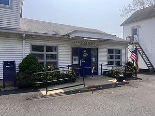
Old Saybrook Center is the primary village and a census-designated place (CDP) in the town of Old Saybrook, Middlesex County, Connecticut, United States. The population was 2,278 at the 2020 census, out of 10,481 in the entire town of Old Saybrook. The CDP includes the traditional town center and the peninsula known as Saybrook Point.

<span class="mw-page-title-main">Westbrook, Connecticut</span> Town in Connecticut, United States

Westbrook is a town in Middlesex County, Connecticut, United States. The town is part of the Lower Connecticut River Valley Planning Region. The population was 6,769 at the 2020 census. The town center is classified by the U.S. Census Bureau as a census-designated place (CDP).

<span class="mw-page-title-main">Long Hill, Groton, Connecticut</span> Census-designated place in Connecticut, United States

Long Hill is a census-designated place (CDP) in the town of Groton in New London County, Connecticut, United States. The population was 4,205 at the 2010 census.

<span class="mw-page-title-main">Poquonock Bridge, Connecticut</span> Census-designated place in Connecticut, United States

Poquonock Bridge is a village and census-designated place (CDP) in the town of Groton in New London County, Connecticut, United States. The population was 1,686 at the 2020 census.

<span class="mw-page-title-main">Somers, Connecticut</span> Town in Connecticut, United States

Somers is a town in Tolland County, Connecticut. The town is part of the Capitol Planning Region. The population was 10,255 at the 2020 census. The town center is listed by the U.S. Census Bureau as a census-designated place (CDP). In 2007, Money Magazine listed Somers 53rd on its "100 Best Places to Live", based on "economic opportunity, good schools, safe streets, things to do and a real sense of community."

<span class="mw-page-title-main">Plainfield Village, Connecticut</span> Village in Connecticut, United States

Plainfield Village is a village and census-designated place (CDP) in the town of Plainfield, Connecticut in the United States. The population was 2,557 at the 2010 census. It is located in the southwest part of town, in the area west of I-395 and south of Route 14. The village is also the core of the Plainfield, CT urban cluster.

<span class="mw-page-title-main">Simsbury Center, Connecticut</span> Census-designated place in Connecticut, United States

Simsbury Center is a census-designated place (CDP) that consists of the central settlement, and the neighborhoods immediately surrounding it, in the town of Simsbury, Connecticut, United States. As of the 2010 census, the CDP had a population of 5,836. The core area of the CDP is listed as the Simsbury Center Historic District on the National Register of Historic Places.

<span class="mw-page-title-main">Southwood Acres, Connecticut</span> Census-designated place in Connecticut, United States

Southwood Acres is a suburban neighborhood within the town of Enfield in northern Hartford County, Connecticut, United States. The neighborhood is listed as a census-designated place (CDP) by the U.S. Census Bureau and had a population of 7,657 at the 2010 census.

<span class="mw-page-title-main">Putnam (CDP), Connecticut</span> Census-designated place in Connecticut, United States

Putnam District is a village and census-designated place (CDP) in Windham County, Connecticut, United States. The CDP was formed when the former city of Putnam disincorporated, and it consists of the main town center of the town of Putnam along the Quinebaug River. The village is part of the Northeastern Connecticut Planning Region. The population was 7,214 at the 2010 census.

<span class="mw-page-title-main">Pleasant Run Farm, Ohio</span> Census-designated place in Ohio, United States

Pleasant Run Farm is a census-designated place (CDP) in Springfield Township, Hamilton County, Ohio, United States. The population was 4,779 at the 2020 census.

<span class="mw-page-title-main">Browns Lake, Wisconsin</span> CDP in Wisconsin, United States

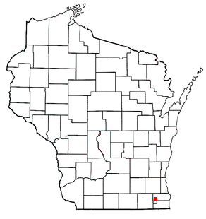
Browns Lake is a census-designated place (CDP) in Racine County, Wisconsin around a lake of the same name. The population was 1,879 at the 2020 census. It is politically a part of the town of Burlington, along with Bohners Lake.

<span class="mw-page-title-main">Glastonbury Center, Connecticut</span> Census-designated place in Connecticut, United States

Glastonbury Center is a census-designated place (CDP) that constitutes the densely populated center of the town of Glastonbury in Hartford County, Connecticut, United States. The population was 7,387 at the 2010 census, out of a total town population of 34,427.

<span class="mw-page-title-main">Salmon Brook, Connecticut</span> Census-designated place in Connecticut, United States

Salmon Brook is the name of a census-designated place (CDP) corresponding to the village of Granby, the primary settlement of the town of Granby, Connecticut, United States, in Hartford County. The population of the CDP was 2,324 as of the 2010 census.

References

  1. 1 2 "Geographic Identifiers: 2010 Demographic Profile Data (G001): West Simsbury CDP, Connecticut". U.S. Census Bureau, American Factfinder. Archived from the original on February 12, 2020. Retrieved November 30, 2012.
  2. "U.S. Census website". United States Census Bureau . Retrieved January 31, 2008.