
Gales Ferry is a village in the town of Ledyard, Connecticut, United States. It is located along the eastern bank of the Thames River. The village developed as a result of having a ferry to Uncasville located at this site, and from which the village was named. Gales Ferry was listed as a census-designated place for the 2010 Census, with a population of 1,162.

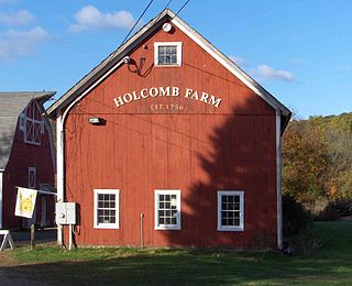
Melrose is a rural village in northeastern East Windsor, Connecticut. Centered at the crossroads of Broad Brook Road and Melrose Road, it was settled in the 1700s and developed as an agrarian village center in the 19th century. A landscape of more than 250 acres (100 ha), including farmland, period farmhouses, ruins of a small distillery, and a district schoolhouse was listed on the National Register of Historic Places in 2010.
The Somersville Historic District encompasses the historic components of the mill village of Somersville in western Somers, Connecticut, United States. The district is centered on a mill complex on the Scantic River, which divides the district. The most significant years of development were between about 1835 and 1935, although the area has a history dating to the 1760s. The district was listed on the National Register of Historic Places in 1995. The Mill itself has since burned down and as of October 2018 is currently open field, although the canal structure remains in place.

The Glastonbury–Rocky Hill Ferry Historic District is a historic district in Glastonbury and Rocky Hill, Connecticut, encompassing a landscape with more than 300 years of colonial and post-colonial history. It includes the ferry landings and water traversed by the Rocky Hill – Glastonbury Ferry, one of the longest-running ferry services the nation, and the surrounding farmscapes and ferry landing village. The district was listed on the National Register of Historic Places in 2005.
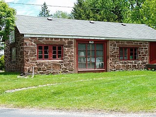
The West Granby Historic District is a historic district in Granby, Connecticut, United States. It encompasses the historic village of West Granby, which extends along Simsbury Road between Firetown Road and Hartland Road. Although this area was settled in the 18th century, and has a few surviving buildings from that time, its most significant period of development was in the 19th century, when industry came to play a role in the area. The district was listed on the National Register of Historic Places in 1992.

The Bradstreet Historic District encompasses the rural 19th-century village of Bradstreet in Hatfield, Massachusetts. It is centered at the junction of Depot Road and Main Street, and includes properties lining those two streets and Old Farm Road. Most of the buildings in the area date to the second half of the 19th century, featuring architectural styles typical of the period, including Queen Anne, Second Empire, Italianate, and Colonial Revival. The village grew on land that was originally granted to colonial governor Simon Bradstreet and divided in 1682, and has remained largely agricultural since then. The district was listed on the National Register of Historic Places in 1997.

Goshen Historic District is a historic district encompassing the town center village of Goshen, Connecticut. Centered at the junction of Connecticut Routes 4 and 63, the village developed historically as a rural crossroads of two turnpikes, and has retained its rural character. It is dominated by residential architecture from the first half of the 19th century, and includes churches, a store, and the town's former 1895 town hall. It was listed on the National Register of Historic Places in 1982.

The Graniteville Historic District is a mainly residential historic district in Waterford, Connecticut. It is ranged along Rope Ferry Road, near granite quarries that were once a major industry in the town. Most of the 31 historical buildings in the district are plain residences occupied by quarry workers; also included are the c. 1878 Graniteville School at 239 Rope Ferry Road, and the house of John Palmer, one of the proprietors of the quarries, at 218 Rope Ferry Road. His house, a c. 1860 Italianate updating of an older house, is the most elaborate house in the district. The district was listed on the National Register of Historic Places in 2003.
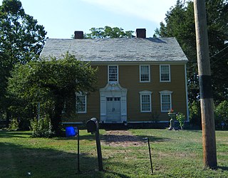
The Ebenezer Grant House is a historic house at 1653 Main St. in the village of East Windsor Hill in South Windsor, Connecticut. Built in 1757–58, it is one of the finest examples of regional colonial architecture in the state. Its rear addition is believed to date to 1695, making it one of the state's oldest surviving colonial structures. The house was listed on the National Register of Historic Places in 1977.

The Parker Hill Rural Historic District encompasses a large rural agricultural landscape in eastern Windham and Windsor counties in the US state of Vermont. Roughly centered on Parker Hill Road in northern Rockingham and southern Springfield, the district exhibits a history of 200 years of farming, including a collection of Federal period farm housing. The district was listed on the National Register of Historic Places in 1993.
The Jericho Rural Historic District encompasses a rural agricultural landscape of northern Hartford, Vermont, extending slightly into neighboring Norwich. The area covers 774 acres (313 ha) of mainly agricultural and formerly agricultural lands, as well as associated woodlots, and includes nine historically significant farm complexes. It was listed on the National Register of Historic Places in 2001.

The Oxbow Historic District encompasses a well-preserved rural agricultural area on United States Route 5 in northern Newbury, Vermont. It was one of the first areas to be settled in the town, and includes seven agricultural properties, with six farmhouses built before 1835 and a number of surviving 19th-century farm outbuildings. It was listed on the National Register of Historic Places in 1983.

The Terraces Historic District encompasses a historic late 19th and early 20th-century residential area of White River Junction, Vermont. The district, developed as an upper middle-class residential area beginning in 1880, features a variety of architectural styles encapsulating the community's growth through about 1930. It was listed on the National Register of Historic Places in 2012.

The South Newbury Village Historic District encompasses the surviving elements of a small industrial village in southern Newbury, Vermont. It includes five residences and several outbuildings, most of which are agricultural in character, representing the area's shift in use in the 20th century. The district was listed on the National Register of Historic Places in 1983.

The Weston Village Historic District encompasses the town center and principal village of Weston, Vermont. Centered on Farrar Park, which serves as the town green, it includes a diversity of architectural styles from the late 18th century to about 1935, and includes residential, civic, commercial, industrial and religious buildings. It was listed on the National Register of Historic Places in 1985.

The Colebrook Center Historic District encompasses the town center of Colebrook, Connecticut. Located in an isolated valley at the junction of Connecticut Route 183 with Rockwell and Smith Hill Roads, the village was established in 1767, and has seen little change since about 1860. It was listed on the National Register of Historic Places in 1991.

The Broad Street Green Historic District encompasses the historic late-19th century town center of Windsor, Connecticut. It is centered around the Broad Street Green, a public park extending on the east side of Broad Street between Union and Batchelder Streets, and includes a diversity of architecture spanning much of the town's long history. It was listed on the National Register of Historic Places in 1999.

The Taylor Chapman House is a historic house at 407 Palisado Avenue in Windsor, Connecticut. Built in 1764, it is a well-preserved example of Georgian architecture executed in brick. It was listed on the National Register of Historic Places in 1988.

The Palisado Avenue Historic District encompasses a predominantly residential streetscape in northeastern Windsor, Connecticut. Extending along Palisado Avenue between the Farmington River and Bissell Ferry Road, it is a basically 18th-century street view, populated mainly with houses from the 18th to the 20th centuries. The district was listed on the National Register of Historic Places in 1987.

The Windsor Farms Historic District encompasses a large historically agricultural area and the historic town center of South Windsor, Connecticut. Its built environment extends mainly along Main Street, between Interstate 291 in the south and Strong Road in the north, with a diversity of architecture spanning three centuries. The district includes agricultural fields on both sides, many of which remain in tobacco cultivation. The district was listed on the National Register of Historic Places in 1986.


