Hazardville, Connecticut

Last updated

Hazardville, Connecticut
HazardvilleCTMainStEastviewCA1906.jpg
Main Street in Hazardville, circa 1906
USA Connecticut location map.svg
Red pog.svg
Hazardville
Usa edcp location map.svg
Red pog.svg
Hazardville
Coordinates: 41°59′14″N72°32′41″W / 41.98722°N 72.54472°W / 41.98722; -72.54472
CountryUnited States
State Connecticut
County Hartford
Town Enfield
Area
  Total3.3 sq mi (8.5 km2)
  Land3.3 sq mi (8.5 km2)
  Water0.0 sq mi (0.0 km2)
Elevation
180 ft (50 m)
Population
 (2010)
  Total4,599
  Density1,400/sq mi (540/km2)
Time zone UTC-5 (Eastern)
  Summer (DST) UTC-4 (Eastern)
ZIP code
06082
Area code 860
FIPS code 09-37770
GNIS feature ID2377824

Hazardville is a section of the town of Enfield, Connecticut, United States, in Hartford County. [1] It is a census-designated place (CDP) that had a total population of 4,599 as of the 2010 census. [2]

Contents

History

Powder mill wreckage, c. 1906 PostcardHazardvilleCTPowderMillWreckageCA1906.jpg
Powder mill wreckage, c. 1906
Powder Hollow, c. 1910 PostcardHazardvilleCTPowderHollowCA1910.jpg
Powder Hollow, c. 1910
School Street, looking north, c. 1910 PostcardEnfieldCTHazardvilleSchoolSt1910.jpg
School Street, looking north, c. 1910
Child laborers in a tobacco shed at Hawthorn Farm in Hazardville, 1917. Photo by Lewis Hine. Tobacco-shed.jpg
Child laborers in a tobacco shed at Hawthorn Farm in Hazardville, 1917. Photo by Lewis Hine.

Hazardville originated as an industrial village centered around the manufacture of gunpowder using water power from the Scantic River. The first small black powder mill was established in 1835 by Allen Loomis in an area then known as Powder Hollow. This became the Hazard Powder Company.

Hazardville takes its name from Colonel Augustus George Hazard. [3]

Historic district

A 1,075-acre (4.35 km2) area in and near Hazardville was listed on the National Register of Historic Places in 1980 as the Hazardville Historic District. [4] The district is an irregularly shaped area that surrounds two interior areas that are not historical and are not included in the district. [5] :37 The district is focused on resources associated with the powder works, and includes industrial archaeological resources on either side of the Scantic River. [5]

Geography

The Hazardville CDP includes, in addition to the original Hazardville village, newer suburban developments east of the Central New England Railroad line to the Somers town line. According to the United States Census Bureau, the CDP has a total area of 3.3 square miles (8.5 km2), all land.

One parcel of the Scantic River State Park is in the Powder Hollow portion of Hazardville. [6]

Demographics

As of the census [7] of 2000, there were 4,900 people, 1,832 households, and 1,337 families residing in the CDP. The population density was 575.0/km2 (1,487.6/mi2). There were 1,876 housing units at an average density of 220.2/km2 (569.6/mi2). The racial makeup of the CDP was 95.45% White, 1.41% African American, 0.22% Native American, 1.41% Asian, 0.02% Pacific Islander, 0.45% from other races, and 1.04% from two or more races. 1.41% of the population were Hispanic or Latino of any race.

There were 1,832 households, out of which 32.4% had children under the age of 18 living with them, 59.4% were married couples living together, 9.1% had a female householder with no husband present, and 27.0% were non-families. 22.3% of all households were made up of individuals, and 10.6% had someone living alone who was 65 years of age or older. The average household size was 2.61 and the average family size was 3.07.

In the CDP, the population was spread out, with 24.3% under the age of 18, 5.4% from 18 to 24, 30.4% from 25 to 44, 21.8% from 45 to 64, and 18.1% who were 65 years of age or older. The median age was 40 years. For every 100 females, there were 94.5 males. For every 100 females age 18 and over, there were 93.2 males.

The median income for a household in the CDP was $54,596, and the median income for a family was $61,183. Males had a median income of $40,606 versus $28,806 for females. The per capita income for the CDP was $22,293. 3.7% of the population and 2.1% of families were below the poverty line. 2.1% of those under the age of 18 and 2.1% of those 65 and older were living below the poverty line.

Related Research Articles

<span class="mw-page-title-main">Georgetown, Connecticut</span> Census-designated place in Connecticut, United States

Georgetown is a census-designated place in Fairfield County, Connecticut, United States. It is located in the area where the towns of Wilton, Redding, Weston, and Ridgefield meet.

<span class="mw-page-title-main">Enfield, Connecticut</span> Town in Connecticut, United States

Enfield is a town in Hartford County, Connecticut, United States, first settled by John and Robert Pease of Salem, Massachusetts Bay Colony. The town is part of the Capitol Planning Region. The population was 42,141 at the 2020 census. It is bordered by Longmeadow, Massachusetts, and East Longmeadow, Massachusetts, to the north, Somers to the east, East Windsor and Ellington to the south, and the Connecticut River to the west.

<span class="mw-page-title-main">Higganum, Connecticut</span> Census-designated place in Connecticut, United States

Higganum is a village and census-designated place (CDP) in the town of Haddam, a part of Middlesex County, Connecticut, United States. The population was 2,089 at the 2020 census.

<span class="mw-page-title-main">Conning Towers Nautilus Park, Connecticut</span> Census-designated place in Connecticut, United States

Conning Towers Nautilus Park is a census-designated place (CDP) in the town of Groton in New London County, Connecticut, United States. The population was 9,828 at the 2010 census. The statistical area consists of the portion of the town in the vicinity of Route 12 and includes Naval Submarine Base New London.

<span class="mw-page-title-main">Mansfield Center, Connecticut</span> CDP in Connecticut, United States

Mansfield Center is a village within the town of Mansfield in Tolland County, Connecticut, United States. The village is the basis of a census-designated place (CDP) of the same name with a population of 947 at the 2010 census. The CDP includes the original settlement of Mansfield, Mansfield Center or Mansfield Village, as well as the village of Mansfield Hollow. Mansfield Hollow State Park is also located within the boundaries of the CDP.

<span class="mw-page-title-main">East Brooklyn, Connecticut</span> Census-designated place in Connecticut, United States

East Brooklyn is a census-designated place (CDP) located within the town of Brooklyn in Windham County, Connecticut. It is the portion of the Danielson urban cluster within the town of Brooklyn. The population was 2,205 at the 2020 census. US 6 runs through the town and severs the town.

<span class="mw-page-title-main">Housatonic, Massachusetts</span> Census-designated place in Massachusetts, United States

Housatonic is a census-designated place (CDP) in the town of Great Barrington in Berkshire County, Massachusetts, United States. It is part of the Pittsfield, Massachusetts Metropolitan Statistical Area. The population was 1,109 at the 2010 census. It was named after the Housatonic River.

<span class="mw-page-title-main">Millers Falls, Massachusetts</span> Census-designated place in Massachusetts, United States

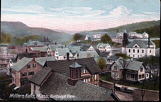
Millers Falls is a census-designated place (CDP) in the towns of Montague and Erving in Franklin County, Massachusetts, United States. The population was 1,139 at the 2010 census. It is part of the Springfield, Massachusetts metropolitan statistical area.

<span class="mw-page-title-main">Shelburne Falls, Massachusetts</span> Census-designated place in Massachusetts, United States

Shelburne Falls is a historic village in the towns of Shelburne and Buckland in Franklin County, Massachusetts, United States. The village is a census-designated place (CDP) with a population of 1,731 at the 2010 census. It is part of the Springfield, Massachusetts, Metropolitan Statistical Area.

<span class="mw-page-title-main">Turners Falls, Massachusetts</span> Census-designated place in Massachusetts, United States

Turners Falls is an unincorporated village and census-designated place in the town of Montague in Franklin County, Massachusetts, United States. The population was 4,512 at the 2020 census. It is part of the Springfield, Massachusetts Metropolitan Statistical Area. Its name is sometimes used as a metonym for the entire town of Montague, for which it is the business district and comprises more than half the population.

<span class="mw-page-title-main">Marshfield Hills, Massachusetts</span> Census-designated place in Massachusetts, United States

Marshfield Hills is a census-designated place (CDP) in the town of Marshfield in Plymouth County, Massachusetts, United States. The population was 2,356 at the 2010 census. The historic center of the village has been designated a historic district and listed on the National Register of Historic Places.

<span class="mw-page-title-main">North Grosvenordale</span> United States historic place

North Grosvenordale is a village and census-designated place (CDP) in the town of Thompson in Windham County, Connecticut, United States. The population was 1,530 at the 2010 census. The core of the village is listed as the North Grosvenordale Mill Historic District on the National Register of Historic Places. The historic area around the cotton mill was listed in 1993 and is located on Riverside Drive, Buckley Hill Road, Floral Avenue, Market Lane, and Marshall, Central, River, and Holmes Streets.

<span class="mw-page-title-main">Wilder, Vermont</span> Census-designated place in Vermont, United States

Wilder is an unincorporated village and census-designated place (CDP) within the town of Hartford in Windsor County, Vermont, United States. It is the location of the Wilder Dam on the Connecticut River. The population of the CDP was 1,690 at the 2010 census. The village center is an early example of a planned mill community, and was listed on the National Register of Historic Places as the Wilder Village Historic District in 1999.

<span class="mw-page-title-main">Powder River, Wyoming</span> Census-designated place in Wyoming, United States

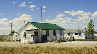
Powder River is a census-designated place (CDP) in Natrona County, Wyoming, United States. It is part of the Casper, Wyoming Metropolitan Statistical Area. The population was 30 in the 2020 census and 44 in the 2010 census.

<span class="mw-page-title-main">Middlebury (CDP), Vermont</span> Census-designated place in Vermont, United States

Middlebury is the main settlement in the town of Middlebury in Addison County, Vermont, United States, and a census-designated place (CDP). The population was 7,304 at the 2020 census, out of a total population of 9,152 in the town of Middlebury. Most of the village is listed on the National Register of Historic Places as the Middlebury Village Historic District.

<span class="mw-page-title-main">Brandon (CDP), Vermont</span> CDP in Vermont, United States

Brandon is an unincorporated village and census-designated place (CDP) in the town of Brandon, Rutland County, Vermont, United States. As of the 2020 census, the population was 1,727.

<span class="mw-page-title-main">Brattleboro (CDP), Vermont</span> CDP in Vermont, United States

Brattleboro is a census-designated place (CDP) corresponding to the densely populated core of the town of Brattleboro in Windham County, Vermont, United States. The population was 8,289 at the 2000 census.

<span class="mw-page-title-main">Arlington (CDP), Vermont</span> Census-designated place in Vermont, United States

Arlington is a census-designated place (CDP) in the towns of Arlington and Sunderland, Bennington County, Vermont, United States. The population was 1,213 at the 2010 census.

<span class="mw-page-title-main">Canaan (village), Connecticut</span> United States historic place

Canaan is a village and census-designated place (CDP) within the town of North Canaan in Litchfield County, Connecticut, United States. Formerly known as Canaan Depot, the village is more commonly known as Canaan Village to distinguish it from the town of Canaan located to the south of North Canaan. The Canaan Village Historic District is listed on the National Register of Historic Places. As of the 2010 census, the CDP had a population of 1,212, out of a total population of 3,315 in the town of North Canaan.

<span class="mw-page-title-main">Litchfield (borough), Connecticut</span> Borough in Connecticut, United States

Litchfield is a borough in, and the village center of, the town of Litchfield in Litchfield County, Connecticut, United States. The population was 1,258 at the 2010 census. The entire borough was designated a Connecticut historic district in 1959 by special act of the state General Assembly and is listed on the National Register of Historic Places. Part of the borough is also a National Historic Landmark, the Litchfield Historic District.

References

  1. Listing of Cities, Towns, Villages, and Boroughs, Connecticut Department of Economic Development website, accessed February 5, 2010
  2. "Geographic Identifiers: 2010 Demographic Profile Data (G001): Hazardville CDP, Connecticut". U.S. Census Bureau, American Factfinder. Archived from the original on February 12, 2020. Retrieved November 29, 2012.
  3. Gannett, Henry (1905). The Origin of Certain Place Names in the United States. Govt. Print. Off. pp.  153.
  4. "National Register Information System". National Register of Historic Places . National Park Service. March 13, 2009.
  5. 1 2 David F. Ransom (February 18, 1979). "National Register of Historic Places Inventory-Nomination: Hazardville Historic District". National Park Service. and Accompanying 24 photos, from 1979
  6. Scantic River State Park, Map 1 of 4, Connecticut Department of Environmental Protection, 10/1/2006
  7. "U.S. Census website". United States Census Bureau . Retrieved January 31, 2008.

Further reading