Related Research Articles

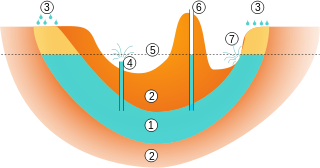
An aquifer is an underground layer of water-bearing, permeable rock, rock fractures, or unconsolidated materials. Groundwater from aquifers can be extracted using a water well. Aquifers vary greatly in their characteristics. The study of water flow in aquifers and the characterization of aquifers is called hydrogeology. Related terms include aquitard, which is a bed of low permeability along an aquifer, and aquiclude, which is a solid, impermeable area underlying or overlying an aquifer, the pressure of which could create a confined aquifer. The classification of aquifers is as follows: Saturated versus unsaturated; aquifers versus aquitards; confined versus unconfined; isotropic versus anisotropic; porous, karst, or fractured; transboundary aquifer.

The Ogallala Aquifer is a shallow water table aquifer surrounded by sand, silt, clay, and gravel located beneath the Great Plains in the United States. As one of the world's largest aquifers, it underlies an area of approximately 174,000 sq mi (450,000 km2) in portions of eight states. It was named in 1898 by geologist N. H. Darton from its type locality near the town of Ogallala, Nebraska. The aquifer is part of the High Plains Aquifer System, and resides in the Ogallala Formation, which is the principal geologic unit underlying 80% of the High Plains.

The water table is the upper surface of the zone of saturation. The zone of saturation is where the pores and fractures of the ground are saturated with water. It can also be simply explained as the depth below which the ground is saturated.
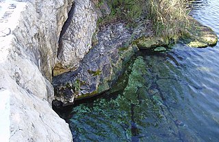
Barton Springs is a set of four natural water springs located at Barton Creek on the grounds of Zilker Park in Austin, Texas, resulting from water flowing through the Edwards Aquifer. The largest spring, Main Barton Spring supplies water to Barton Springs Pool, a popular recreational destination in Austin. The smaller springs are located nearby, two with man-made structures built to contain and direct their flow. The springs are the only known habitat of the Barton Springs Salamander, an endangered species.

Groundwater is the water present beneath Earth's surface in rock and soil pore spaces and in the fractures of rock formations. About 30 percent of all readily available freshwater in the world is groundwater. A unit of rock or an unconsolidated deposit is called an aquifer when it can yield a usable quantity of water. The depth at which soil pore spaces or fractures and voids in rock become completely saturated with water is called the water table. Groundwater is recharged from the surface; it may discharge from the surface naturally at springs and seeps, and can form oases or wetlands. Groundwater is also often withdrawn for agricultural, municipal, and industrial use by constructing and operating extraction wells. The study of the distribution and movement of groundwater is hydrogeology, also called groundwater hydrology.

Hydrogeology is the area of geology that deals with the distribution and movement of groundwater in the soil and rocks of the Earth's crust. The terms groundwater hydrology, geohydrology, and hydrogeology are often used interchangeably.
An artesian well is a well that brings groundwater to the surface without pumping because it is under pressure within a body of rock and/or sediment known as an aquifer. When trapped water in an aquifer is surrounded by layers of impermeable rock or clay, which apply positive pressure to the water, it is known as an artesian aquifer. If a well were to be sunk into an artesian aquifer, water in the well-pipe would rise to a height corresponding to the point where hydrostatic equilibrium is reached.
An aquifer test is conducted to evaluate an aquifer by "stimulating" the aquifer through constant pumping, and observing the aquifer's "response" (drawdown) in observation wells. Aquifer testing is a common tool that hydrogeologists use to characterize a system of aquifers, aquitards and flow system boundaries.
Fossil water or paleowater is an ancient body of water that has been contained in some undisturbed space, typically groundwater in an aquifer, for millennia. Other types of fossil water can include subglacial lakes, such as Antarctica's Lake Vostok, and even ancient water on other planets.
Hydraulic conductivity, symbolically represented as K, is a property of porous materials, soils and rocks, that describes the ease with which a fluid can move through the pore space, or fractures network. It depends on the intrinsic permeability of the material, the degree of saturation, and on the density and viscosity of the fluid. Saturated hydraulic conductivity, Ksat, describes water movement through saturated media. By definition, hydraulic conductivity is the ratio of volume flux to hydraulic gradient yielding a quantitative measure of a saturated soil's ability to transmit water when subjected to a hydraulic gradient.
In the field of hydrogeology, storage properties are physical properties that characterize the capacity of an aquifer to release groundwater. These properties are storativity (S), specific storage (Ss) and specific yield (Sy). According to Groundwater, by Freeze and Cherry (1979), specific storage, [m−1], of a saturated aquifer is defined as the volume of water that a unit volume of the aquifer releases from storage under a unit decline in hydraulic head.
The Floridan aquifer system, composed of the Upper and Lower Floridan aquifers, is a sequence of Paleogene carbonate rock which spans an area of about 100,000 square miles (260,000 km2) in the southeastern United States. It underlies the entire state of Florida and parts of Alabama, Georgia, Mississippi, and South Carolina.

The Edwards Aquifer is one of the most prolific artesian aquifers in the world. Located on the eastern edge of the Edwards Plateau in the U.S. state of Texas, it is the source of drinking water for two million people, and is the primary water supply for agriculture and industry in the aquifer's region. Additionally, the Edwards Aquifer feeds the Comal and San Marcos springs, provides springflow for recreational and downstream uses in the Nueces, San Antonio, Guadalupe, and San Marcos river basins, and is home to several unique and endangered species.
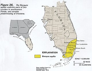
The Biscayne Aquifer, named after Biscayne Bay, is a surficial aquifer. It is a shallow layer of highly permeable limestone under a portion of South Florida. The area it underlies includes Broward County, Miami-Dade County, Monroe County, and Palm Beach County, a total of about 4,000 square miles (10,000 km2).
Overdrafting is the process of extracting groundwater beyond the equilibrium yield of an aquifer. Groundwater is one of the largest sources of fresh water and is found underground. Groundwater depletion is comparable to a bank account in which more money is withdrawn than deposited. The primary cause of groundwater depletion is the excessive pumping of groundwater up from underground aquifers.

A well is an excavation or structure created in the ground by digging, driving, or drilling to access liquid resources, usually water. The oldest and most common kind of well is a water well, to access groundwater in underground aquifers. The well water is drawn up by a pump, or using containers, such as buckets or large water bags that are raised mechanically or by hand. Water can also be injected back into the aquifer through the well. Wells were first constructed at least eight thousand years ago and historically vary in construction from a simple scoop in the sediment of a dry watercourse to the qanats of Iran, and the stepwells and sakiehs of India. Placing a lining in the well shaft helps create stability, and linings of wood or wickerwork date back at least as far as the Iron Age.
Aquifer storage and recovery (ASR) is the direct injection of surface water supplies such as potable water, reclaimed water, or river water into an aquifer for later recovery and use. The injection and extraction is often done by means of a well. In areas where the rainwater cannot percolate the soil or where it is not capable of percolating it fast enough and where the rainwater is thus diverted to rivers, rainwater ASR could help to keep the rainwater within an area. ASR is used for municipal, industrial and agricultural purposes.

Gorgonum Chaos is a set of canyons in the Phaethontis quadrangle of Mars. It is located at 37.5° south latitude and 170.9° west longitude. Its name comes from an albedo feature at 24S, 154W. Some of the first gullies on Mars were found in Gorgonum Chaos. It is generally believed that it once contained a lake. Other nearby features are Sirenum Fossae, Maadim Vallis, Ariadnes Colles, and Atlantis Chaos. Some of the surfaces in the region are formed from the Electris deposits.
Groundwater pollution occurs when pollutants are released to the ground and make their way into groundwater. This type of water pollution can also occur naturally due to the presence of a minor and unwanted constituent, contaminant, or impurity in the groundwater, in which case it is more likely referred to as contamination rather than pollution. Groundwater pollution can occur from on-site sanitation systems, landfill leachate, effluent from wastewater treatment plants, leaking sewers, petrol filling stations, hydraulic fracturing (fracking) or from over application of fertilizers in agriculture. Pollution can also occur from naturally occurring contaminants, such as arsenic or fluoride. Using polluted groundwater causes hazards to public health through poisoning or the spread of disease.

Oak Lake is a lake in the south-western part of the Canadian province of Manitoba in a region called Westman. Oak Lake is a kettle lake and is an aquifer supplier for numerous nearby residential areas and farms. The lake is in the RM of Sifton and sits at an elevation of 426 metres above sea level. Provincial Road 254 provides access to the lake.
References
- ↑ Probst, AJ; Castelle, CJ; Singh, A; Brown, CT; Anantharaman, K; Sharon, I; Hug, LA; Burstein, D; Emerson, JB; Thomas, BC; Banfield, JF (February 2017). "Genomic resolution of a cold subsurface aquifer community provides metabolic insights for novel microbes adapted to high CO2 concentrations". Environmental Microbiology. 19 (2): 459–474. doi:10.1111/1462-2920.13362. OSTI 1567074. PMID 27112493. S2CID 21126011.
| | This bacteria-related article is a stub. You can help Wikipedia by expanding it. |