Baileyville, Maine

Last updated

Baileyville, Maine
Nickname: 
Woodland
Motto: 
"...The Road to Home" [1]
USA Maine location map.svg
Red pog.svg
Baileyville, Maine
Location within the state of Maine
Coordinates: 45°9′29″N67°25′8″W / 45.15806°N 67.41889°W / 45.15806; -67.41889
Country United States
State Maine
County Washington
Area
[2]
  Total41.91 sq mi (108.55 km2)
  Land37.15 sq mi (96.22 km2)
  Water4.76 sq mi (12.33 km2)
Elevation
249 ft (76 m)
Population
 (2020)
  Total1,318
  Density35/sq mi (13.7/km2)
Time zone UTC-5 (Eastern (EST))
  Summer (DST) UTC-4 (EDT)
04694
04694
Area code 207
FIPS code 23-02480
GNIS feature ID0582337
Website Baileyville, Maine

Baileyville is a town in Washington County, Maine, United States. The population was 1,318 at the 2020 census. [3] Within the town is the census-designated place of Woodland. The town was originally settled by Quakers in 1780. In 1830, Ezekiel Bailey began the commercial manufacture of oilcloth. The business flourished and expanded until it comprised several factories, which burned down in 1921. [4]

Contents

Geography

According to the United States Census Bureau, the town has a total area of 41.91 square miles (108.55 km2), of which 37.15 square miles (96.22 km2) is land and 4.76 square miles (12.33 km2) is water. [2]

History

Water powered sawmills and paper mills at Woodland used wooden logs and pulpwood floated down the Saint Croix River. These mills were connected to the national rail network via the Maine Central Railroad and under Georgia-Pacific operation [5] originated or terminated over 6,000 railway carloads in 1973. [6] The Maine Central business has since been discontinued, and the only rail service left as of 2012 was a spur line that connected Woodland to St. Stephen, New Brunswick for the shipment of pulp and paper to Saint John.

Demographics

Historical population
CensusPop.Note
1830 189
1840 32974.1%
1850 43131.0%
1860 363−15.8%
1870 3773.9%
1880 376−0.3%
1890 226−39.9%
1900 215−4.9%
1910 1,137428.8%
1920 2,24397.3%
1930 2,017−10.1%
1940 2,0180.0%
1950 1,821−9.8%
1960 1,8632.3%
1970 2,16716.3%
1980 2,1881.0%
1990 2,031−7.2%
2000 1,686−17.0%
2010 1,521−9.8%
2020 1,318−13.3%
U.S. Decennial Census [7]

2010 census

As of the census [8] of 2010, there were 1,521 people, 662 households, and 444 families residing in the town. The population density was 40.9 inhabitants per square mile (15.8/km2). There were 875 housing units at an average density of 23.6 per square mile (9.1/km2). The racial makeup of the town was 95.7% White, 0.7% African American, 0.8% Native American, 0.7% Asian, 0.1% Pacific Islander, 0.2% from other races, and 1.9% from two or more races. Hispanic or Latino of any race were 0.7% of the population.

There were 662 households, of which 28.1% had children under the age of 18 living with them, 49.2% were married couples living together, 12.7% had a female householder with no husband present, 5.1% had a male householder with no wife present, and 32.9% were non-families. 27.6% of all households were made up of individuals, and 13.4% had someone living alone who was 65 years of age or older. The average household size was 2.30 and the average family size was 2.73.

The median age in the town was 46.8 years. 21.2% of residents were under the age of 18; 5.1% were between the ages of 18 and 24; 21.5% were from 25 to 44; 32.4% were from 45 to 64; and 20% were 65 years of age or older. The gender makeup of the town was 48.1% male and 51.9% female.

2000 census

As of the census [9] of 2000, there were 1,686 people, 726 households, and 484 families residing in the town. The population density was 46.2 inhabitants per square mile (17.8/km2). There were 927 housing units at an average density of 25.4 per square mile (9.8/km2). The racial makeup of the town was 98.22% White, 0.06% African American, 0.12% Native American, 0.12% Asian, 0.59% from other races, and 0.89% from two or more races. Hispanic or Latino of any race were 0.59% of the population.

There were 726 households, out of which 26.4% had children under the age of 18 living with them, 54.0% were married couples living together, 8.8% had a female householder with no husband present, and 33.2% were non-families. 28.4% of all households were made up of individuals, and 12.5% had someone living alone who was 65 years of age or older. The average household size was 2.32 and the average family size was 2.82.

In the town, the population was spread out, with 22.8% under the age of 18, 6.3% from 18 to 24, 26.9% from 25 to 44, 27.5% from 45 to 64, and 16.4% who were 65 years of age or older. The median age was 42 years. For every 100 females, there were 95.6 males. For every 100 females age 18 and over, there were 92.6 males.

The median income for a household in the town was $31,658, and the median income for a family was $37,292. Males had a median income of $38,269 versus $19,531 for females. The per capita income for the town was $17,087. About 9.1% of families and 10.1% of the population were below the poverty line, including 12.5% of those under age 18 and 8.9% of those age 65 or over.

Education

The high school, Woodland Jr./Sr. High School, has about 250 students in grades 7–12. The school's principal is Michealene Spencer. Woodland Jr/Sr High School's mascot is the Dragons, and the school's colors are purple and gold.

Sports are an important part of the school's culture. The school offers JV and varsity girls' volleyball, varsity co-ed cross country, boys' and girls' soccer, boys' and girls' basketball, co-ed wrestling, co-ed cheerleading, baseball, softball, tennis, and e-sports. The boys soccer team participated in the very first Class C State Championship in 1974, losing 3–0 to Richmond High School at the University of Maine. The school has won the Class D Girls' Basketball Championship 4 times, most recently in 2008. Also, in the 2008–2009 season, the boys' basketball team won the Class D Boys' Basketball Championship for the first time in the history of the school, making Woodland High School the first school since 1994 to win both Boys' and Girls' State Championships. In 2009, the girls' softball team also won the school's first State Softball Championship. The varsity Cheerleading team won the school's first ever State Championship by capturing the Class D State Championship in 1993. The cheerleading team won the Class C State Cheerleading Championship in 1997 by completing a "perfect season" in which they never lost in any round of competition.

Related Research Articles

<span class="mw-page-title-main">Germantown, Illinois</span> Village in Illinois, United States

Germantown is a village in Clinton County, Illinois, United States. The population was 1,324 at the 2020 census.

<span class="mw-page-title-main">Steeleville, Illinois</span> Village in Illinois, United States

Steeleville is a village in Randolph County, Illinois, United States. The population was 2,083 at the 2010 census.

<span class="mw-page-title-main">Durham, Maine</span> Town in the state of Maine, United States

Durham is a town in Androscoggin County, Maine, United States. The population was 4,173 at the 2020 census. It is included in both the Lewiston-Auburn, Maine Metropolitan Statistical Area and the Lewiston-Auburn, Maine Metropolitan New England City and Town Area.

<span class="mw-page-title-main">Wales, Maine</span> Town in the state of Maine, United States

Wales is a town in Androscoggin County, Maine, United States. The population was 1,608 at the 2020 census. It is included in both the Lewiston-Auburn, Maine Metropolitan Statistical Area and the Lewiston-Auburn, Maine Metropolitan New England City and Town Area.

<span class="mw-page-title-main">Hodgdon, Maine</span> Town in the state of Maine, United States

Hodgdon is a rural town in Aroostook County, Maine, United States. The town borders the province of New Brunswick, Canada to the east and Houlton to the north. Hodgdon's population was 1,290 at the 2020 census.

<span class="mw-page-title-main">Littleton, Maine</span> Town in the state of Maine, United States

Littleton is a town in Aroostook County, Maine, United States. The population was 997 at the 2020 census.

<span class="mw-page-title-main">St. Francis, Maine</span> Town in the state of Maine, United States

St. Francis is a town in Aroostook County, Maine, United States on the Canada–United States border at the junction of the St. Francis River and the Saint John River. The population was 438 at the 2020 census. First settled by English speakers from southern Maine, the original population has been supplanted by French-speaking Acadians.

<span class="mw-page-title-main">Mount Vernon, Maine</span> Town in the state of Maine, United States

Mount Vernon is a town in Kennebec County, Maine, United States. The population was 1,721 at the 2020 census. Mount Vernon is included in the Augusta, Maine micropolitan New England City and Town Area. A popular recreation spot in central Maine, the northern area of Mount Vernon is part of the Belgrade Lakes Region, while the southern area is part of the Winthrop Lakes Region.

Woodstock is a town in Oxford County, Maine, United States. Woodstock is included in the Lewiston-Auburn, Maine metropolitan New England city and town area. The population was 1,352 at the 2020 census. The village of Bryant Pond, on State Route 26 in the northern part of Woodstock, is the town's urban center and largest settlement.

<span class="mw-page-title-main">Bowdoin, Maine</span> Town in the state of Maine, United States

Bowdoin is a town in Sagadahoc County, Maine, United States. Bowdoin is included in the Lewiston-Auburn, Maine metropolitan New England city and town area. The population was 3,136 at the 2020 census. Bowdoin is 31 land miles north of Portland, and 21 land miles south of Augusta.

<span class="mw-page-title-main">Marble Hill, Missouri</span> City in Missouri, United States

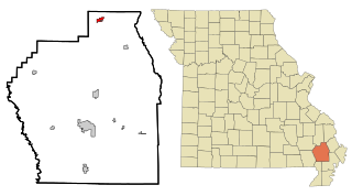
Marble Hill is a fourth-class city in central Bollinger County in Southeast Missouri, United States. Located at the intersection of State Highways 34 and 51, it is the largest city in Bollinger and serves as the county seat. The population was 1,388 at the 2020 census. The city was officially organized in July 1851 and is named after a marble-like rock.

<span class="mw-page-title-main">Advance, Missouri</span> City in Missouri, United States

Advance is a city located at the intersection of State Highway 25 and State Highway 91/Route C in northern Stoddard County, Missouri, United States. The population was 1,347 at the 2010 census. Advance was founded circa 1882. The town is pronounced ADD-vance.

<span class="mw-page-title-main">Boys Town, Nebraska</span> Village in Douglas County, Nebraska, United States

Boys Town is a village in Douglas County, Nebraska, United States. The population was 410 at the 2020 census. Boys Town is an enclave and a suburb of Omaha.

<span class="mw-page-title-main">Jane Lew, West Virginia</span> Town in West Virginia, United States

Jane Lew is a town in Lewis County, West Virginia, United States. The population was 409 at the time of the 2020 census.

<span class="mw-page-title-main">Baileyville, Kansas</span> Unincorporated community in Nemaha County, Kansas

Baileyville is an unincorporated community in western Nemaha County, Kansas, United States. As of the 2020 census, the population of the community and nearby areas was 182. It is located six miles west of Seneca on U.S. Route 36.

<span class="mw-page-title-main">Van Buren, Maine</span> Town in Maine, United States

Van Buren is a town on the Saint John River in Aroostook County, Maine, United States; located across from Saint-Leonard, New Brunswick, Canada. The population was 2,038 at the 2020 census. It is named after U.S. President Martin Van Buren.

<span class="mw-page-title-main">Woodland, Aroostook County, Maine</span> Town in the state of Maine, United States

Woodland is a town in Aroostook County, Maine, United States. The population was 1,217 at the 2020 census. Because the state of Maine has a law stating that no two towns may share the same name, Woodland of Aroostook County and Woodland of Washington County found themselves before the Maine Supreme Judicial Court in the late 1990s. Because it was founded as a township first, Woodland of Aroostook County was allowed to keep its name and Woodland of Washington County was ordered by the court to choose a new name: Baileyville.

Woodland is a census-designated place (CDP) in the town of Baileyville, Washington County, Maine, United States. The population was 952 at the 2010 census.

<span class="mw-page-title-main">East Millinocket, Maine</span> Town in the state of Maine, United States

East Millinocket is a town in Penobscot County, Maine, United States. The population was 1,572 at the 2020 census.

Lincoln is a town in Penobscot County, Maine, United States. The town's population was 4,853 at the 2020 United States Census. A statue honoring Medal of Honor recipient Gary Gordon was installed in Lincoln, in 2021. The 10-foot (3.0 m) bronze sculpture faces Gordon's grave at Park Street Cemetery.

References

  1. "Baileyville, Maine". Baileyville, Maine. Retrieved August 26, 2012.
  2. 1 2 "US Gazetteer files 2010". United States Census Bureau . Retrieved December 16, 2012.
  3. "Census - Geography Profile: Baileyville town, Washington County, Maine". United States Census Bureau . Retrieved January 20, 2022.
  4. Maine League of Historical Societies and Museums (1970). Doris A. Isaacson (ed.). Maine: A Guide 'Down East'. Rockland, Me: Courier-Gazette, Inc. p. 162.
  5. 470 Railroad Club (1981). Meet the Maine Central. KJ Printing. p. 63.{{cite book}}: CS1 maint: numeric names: authors list (link)
  6. United States Department of Transportation (1974). Rail Service in the Midwest and Northeast Region. United States Government Printing Office.
  7. "Census of Population and Housing". Census.gov. Retrieved June 4, 2015.
  8. "U.S. Census website". United States Census Bureau . Retrieved December 16, 2012.
  9. "U.S. Census website". United States Census Bureau . Retrieved January 31, 2008.