Crawford, Maine

Last updated

Crawford, Maine
USA Maine location map.svg
Red pog.svg
Crawford, Maine
Location within the state of Maine
Coordinates: 45°0′20″N67°34′19″W / 45.00556°N 67.57194°W / 45.00556; -67.57194
Country United States
State Maine
County Washington
Area
[1]
  Total37.78 sq mi (97.85 km2)
  Land34.52 sq mi (89.41 km2)
  Water3.26 sq mi (8.44 km2)
Elevation
131 ft (40 m)
Population
 (2020)
  Total93
  Density3/sq mi (1.0/km2)
Time zone UTC-5 (Eastern (EST))
  Summer (DST) UTC-4 (EDT)
ZIP code
04694
Area code 207
FIPS code 23-14940
GNIS feature ID0582424

Crawford is a town in Washington County, Maine, United States. The town was named after William H. Crawford, Secretary of the Treasury. [2] The population was 93 at the 2020 census. [3]

Contents

History

Crawford was incorporated on February 11, 1828, under the name Adams, presumably after then-incumbent President, John Q. Adams. The name was changed to Crawford only 17 days later on February 28, 1828, in honor of former Secretary of Treasury William H. Crawford of Georgia. [4]

Geography

According to the United States Census Bureau, the town has a total area of 37.78 square miles (97.85 km2), of which 34.52 square miles (89.41 km2) is land and 3.26 square miles (8.44 km2) is water. [1]

Adjacent municipalities

Demographics

Historical population
CensusPop.Note
1830 182
1840 30064.8%
1850 3248.0%
1860 273−15.7%
1870 209−23.4%
1880 206−1.4%
1890 140−32.0%
1900 112−20.0%
1910 1141.8%
1920 1194.4%
1930 1200.8%
1940 13613.3%
1950 83−39.0%
1960 830.0%
1970 74−10.8%
1980 8616.2%
1990 893.5%
2000 10821.3%
2010 105−2.8%
2020 93−11.4%
U.S. Decennial Census [5]

2010 census

As of the census [6] of 2010, there were 105 people, 48 households, and 32 families living in the town. The population density was 3.0 inhabitants per square mile (1.2/km2). There were 118 housing units at an average density of 3.4 per square mile (1.3/km2). The racial makeup of the town was 100.0% White. Hispanic or Latino of any race were 1.9% of the population.

There were 48 households, of which 27.1% had children under the age of 18 living with them, 60.4% were married couples living together, 4.2% had a female householder with no husband present, 2.1% had a male householder with no wife present, and 33.3% were non-families. 27.1% of all households were made up of individuals, and 10.4% had someone living alone who was 65 years of age or older. The average household size was 2.19 and the average family size was 2.63.

The median age in the town was 50.5 years. 17.1% of residents were under the age of 18; 4.9% were between the ages of 18 and 24; 11.5% were from 25 to 44; 43.8% were from 45 to 64; and 22.9% were 65 years of age or older. The gender makeup of the town was 44.8% male and 55.2% female.

2000 census

As of the census [7] of 2000, there were 108 people, 41 households, and 31 families living in the town. The population density was 3.1 inhabitants per square mile (1.2/km2). There were 99 housing units at an average density of 2.9 per square mile (1.1/km2). The racial makeup of the town was 97.22% White, 0.93% Native American, 0.93% from other races, and 0.93% from two or more races. Hispanic or Latino of any race were 0.93% of the population.

There were 41 households, out of which 29.3% had children under the age of 18 living with them, 58.5% were married couples living together, 12.2% had a female householder with no husband present, and 22.0% were non-families. 17.1% of all households were made up of individuals, and 9.8% had someone living alone who was 65 years of age or older. The average household size was 2.63 and the average family size was 2.88.

In the town, the population was spread out, with 28.7% under the age of 18, 1.9% from 18 to 24, 29.6% from 25 to 44, 22.2% from 45 to 64, and 17.6% who were 65 years of age or older. The median age was 39 years. For every 100 females, there were 100.0 males. For every 100 females age 18 and over, there were 108.1 males.

The median income for a household in the town was $43,125, and the median income for a family was $27,083. Males had a median income of $46,250 versus $25,625 for females. The per capita income for the town was $13,864. There were 24.1% of families and 24.0% of the population living below the poverty line, including 31.3% of under eighteens and 25.9% of those over 64.

Related Research Articles

<span class="mw-page-title-main">Bridgewater, Maine</span> Town in the state of Maine, United States

Bridgewater is a town in Aroostook County, Maine, United States. The population was 532 at the 2020 census.

<span class="mw-page-title-main">Castle Hill, Maine</span> Town in the state of Maine, United States

Castle Hill is a town in Aroostook County, Maine, United States. The population was 373 people at the 2020 census.

<span class="mw-page-title-main">Merrill, Maine</span> Town in the state of Maine, United States

Merrill is a town in Aroostook County, Maine, United States. The population was 208 at the 2020 census.

<span class="mw-page-title-main">Moro Plantation, Maine</span> Plantation in Maine, United States

Moro Plantation is a plantation in Aroostook County, Maine, United States. The population was 44 at the 2020 census.

<span class="mw-page-title-main">Wade, Maine</span> Town in the state of Maine, United States

Wade is a town in Aroostook County, Maine, United States. The population was 229 at the 2020 census.

<span class="mw-page-title-main">Wayne, Maine</span> Town in the state of Maine, United States

Wayne is a town in Kennebec County, Maine, United States. Wayne is included in the Lewiston-Auburn, Maine metropolitan New England city and town area. The population was 1,129 at the 2020 census. The town was named after Revolutionary War General Anthony Wayne. During the summer, Wayne is home to Camp Androscoggin. A popular recreation spot in central Maine, Wayne is part of the Winthrop Lakes Region. The town is included in the Augusta, Maine micropolitan New England City and Town Area. and included in the Lewiston-Auburn, Maine metropolitan New England city and town area.

Bradley is a town in Penobscot County, Maine, United States. It is part of the Bangor Metropolitan Statistical Area. The population was 1,532 at the 2020 census. The village of Bradley is in the northwestern corner of the town.

Kenduskeag is a town in Penobscot County, Maine, United States. The population was 1,346 at the 2020 census.

Lakeville is a town in Penobscot County, Maine, United States. The population was 104 at the 2020 census.

Springfield is a town in Penobscot County, Maine, United States. The population was 293 at the 2020 census.

Palmyra is a town in Somerset County, Maine, United States. The population was 1,924 at the 2020 census.

<span class="mw-page-title-main">Troy, Maine</span> Town in the state of Maine, United States

Troy is a town in Waldo County, Maine, United States. The population was 1,018 at the 2020 census.

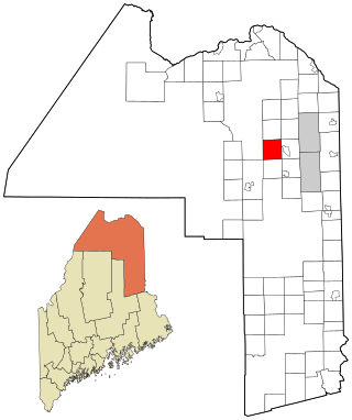
Charlotte is a town in Washington County, Maine, United States. The town was named for the wife of legislator William Vance. The population was 337 at the 2020 census.

Cooper is a town in Washington County, Maine, United States. The community was named after General John Cooper, a landowner. The population was 168 at the 2020 census.

<span class="mw-page-title-main">Cutler, Maine</span> Town in the state of Maine, United States

Cutler is a town in Washington County, Maine, United States. The town was named after Joseph Cutler, an early settler, who hailed from Newburyport, Massachusetts. The population was 524 at the 2020 census.

Wesley is a town in Washington County, Maine, United States. The town was named after John Wesley, founder of the English Methodist movement. The population was 122 at the 2020 census.

<span class="mw-page-title-main">Whiting, Maine</span> Town in Maine, United States

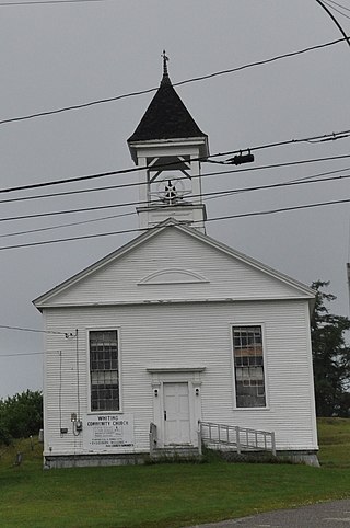
Whiting is a town in Washington County, Maine, United States. The town was named after Tate Whiting, an early settler. The population was 482 at the 2020 census. The town was originally known as Orangetown.

<span class="mw-page-title-main">Belmont, West Virginia</span> Town in West Virginia, United States

Belmont is a town in Pleasants County, West Virginia, United States. It is part of the Parkersburg–Vienna metropolitan area. The population was 872 at the 2020 census. Belmont was incorporated on April 19, 1946 by the Circuit Court of Pleasants County. The city was named for the beautiful hills in the area.

Rumford is a census-designated place (CDP) in the town of Rumford in Oxford County, Maine, United States. The population was 4,795 at the 2000 census.

<span class="mw-page-title-main">East Millinocket, Maine</span> Town in the state of Maine, United States

East Millinocket is a town in Penobscot County, Maine, United States. The population was 1,572 at the 2020 census.

References

  1. 1 2 "US Gazetteer files 2010". United States Census Bureau . Retrieved December 16, 2012.
  2. "Profile for Crawford, Maine". ePodunk . Retrieved May 8, 2010.
  3. "Census - Geography Profile: Crawford town, Washington County, Maine". United States Census Bureau . Retrieved March 14, 2022.
  4. "Crawford". Maine: An Encyclopedia. October 28, 2011. Retrieved October 15, 2019.
  5. "Census of Population and Housing". Census.gov. Retrieved June 4, 2015.
  6. "U.S. Census website". United States Census Bureau . Retrieved December 16, 2012.
  7. "U.S. Census website". United States Census Bureau . Retrieved January 31, 2008.

45°03′10″N67°33′05″W / 45.05278°N 67.55139°W / 45.05278; -67.55139