
Washington County is a county located in the U.S. state of Maine. As of the 2020 census, its population was 31,095, making it the third-least populous county in Maine. Its county seat is Machias. The county was established on June 25, 1789. It borders the Canadian province of New Brunswick.

Blaine is a town in Aroostook County, Maine, United States. The population was 667 at the 2020 census. It was known as Alva prior to incorporation in 1874, when it was renamed in honor of James G. Blaine, then Speaker of the U.S. House of Representatives. According to local history, Blaine offered to donate a large bell for the tower of the town's new meeting hall, if the citizens would rename the town after him. The town's name was changed, but Blaine never donated a bell. The building still stands on the north end of town, on Route 1.

Bridgewater is a town in Aroostook County, Maine, United States. The population was 532 at the 2020 census.

New Limerick is a town in Aroostook County, Maine, United States. The population was 574 at the 2020 census. The town was settled in 1775 and incorporated on March 18, 1837, from New Limerick Plantation. It received its name from the fact that many of its settlers had previously lived in Limerick in York County at the southern end of the state, which in turn was probably named after the Irish city of Limerick.
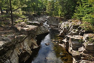
Byron is a town in Oxford County, Maine, United States. The population was 103 at the 2020 census. Home to Coos Canyon on the Swift River, Byron includes the village of Houghton.

Old Town is a city in Penobscot County, Maine, United States. The population was 7,431 at the 2020 census. The city's developed area is chiefly located on the relatively large Marsh Island, but its boundaries extend beyond it. The island is surrounded and defined by the Penobscot River to the east and the Stillwater River to the west.
Springfield is a town in Penobscot County, Maine, United States. The population was 293 at the 2020 census.
Stetson is a town in Penobscot County, Maine, United States. The population was 1,186 at the 2020 census. It was named after its first proprietor, Amasa Stetson. His brother Simeon Stetson originally settled here as well, but moved to nearby Hampden in 1803. Simeon's sons Charles, George, and Isaiah founded a powerful mercantile and political family in Bangor.

Veazie is a town in Penobscot County, Maine, United States. The population was 1,814 at the 2020 census. The town is named after General Samuel Veazie, an early lumber baron and railroad operator. Veazie was originally part of Bangor, using Penobscot River water power to operate sawmills. It became a separate town in 1853 because Gen. Veazie, its wealthiest citizen, thought Bangor's property taxes were too high.
Sebec is a town in Piscataquis County, Maine, United States. The population was 665 at the 2020 census.

Frankfort is a town on the Penobscot River estuary in Waldo County, Maine, United States. The population was 1,231 at the 2020 census.
Alexander is a town in Washington County, Maine, United States. The population was 525 at the 2020 census. The town is named for Alexander Baring, 1st Baron Ashburton, the British negotiator of the Webster–Ashburton Treaty which ended the Aroostook War in 1838–1839.

Cherryfield is a town in Washington County, Maine, United States on the Narraguagus River. It was named for the wild cherries that once peppered the banks of the river. The town population was 1,107 at the 2020 census. The town bills itself as the "Blueberry Capital of the World". Roughly 75 acres (300,000 m2) on both sides of the river are a historic district on the National Register of Historic Places known as the Cherryfield Historic District. This district comprises a collection of period structures dating from c. 1750–1890. The town was first settled about 1760. In 1826,the part of Steuben known as Narraguagus was annexed onto Cherryfield.

Harrington is a town in Washington County, Maine, United States. The population was 962 at the 2020 census. Harrington is an old seafaring and shipbuilding village.
Princeton is a town in Washington County, Maine, United States. The town was named after Princeton, Massachusetts. The population was 745 at the 2020 census.
Vanceboro is a town in Washington County, Maine, United States. The town was named after landowner William Vance. The main village in town is located at the eastern terminus of Maine State Route 6. Vanceboro is across the St. Croix River from St. Croix, New Brunswick, Canada, to which it is connected by the Saint Croix–Vanceboro Bridge. Vanceboro is also connected to St. Croix by the Saint Croix–Vanceboro Railway Bridge, which is used by the New Brunswick Southern Railway.

Whitneyville is a town in Washington County, Maine, United States. The town was named after Colonel Joseph Whitney, a mill owner. The population was 202 at the 2020 census.

Fort Fairfield is a census-designated place (CDP) comprising the main village within the town of Fort Fairfield in Aroostook County, Maine, United States. The population of the CDP was 1,825 at the 2010 census, out of a population of 3,496 for the entire town.

Fort Fairfield is a town in Aroostook County, eastern Maine, United States, located along the Canada–US border. The population was 3,322 at the 2020 census.
Milford is a town in Penobscot County, Maine, United States. It is located across the Penobscot River from the city of Old Town. The population of Milford was 3,069 at the 2020 census. The town's slogan is the "Best little town by a dam site," referring to the Milford Dam abutting Milford on the Penobscot River, south of the Penobscot Indian Island Reservation.


