Topsfield, Maine

Last updated

Topsfield, Maine
USA Maine location map.svg
Red pog.svg
Topsfield, Maine
Location within the state of Maine
Coordinates: 45°25′35″N67°45′36″W / 45.42639°N 67.76000°W / 45.42639; -67.76000
Country United States
State Maine
County Washington
Area
[1]
  Total55.32 sq mi (143.28 km2)
  Land50.09 sq mi (129.73 km2)
  Water5.23 sq mi (13.55 km2)
Elevation
430 ft (131 m)
Population
 (2020)
  Total179
  Density4/sq mi (1.4/km2)
Time zone UTC-5 (Eastern (EST))
  Summer (DST) UTC-4 (EDT)
ZIP code
04490
Area code 207
FIPS code 23-76895
GNIS feature ID0582765

Topsfield is a town in Washington County, Maine, United States. The population was 179 at the 2020 census. [2]

Contents

Geography

According to the United States Census Bureau, the town has a total area of 55.32 square miles (143.28 km2), of which 50.09 square miles (129.73 km2) is land and 5.23 square miles (13.55 km2) is water. [1]

Climate

This climatic region is typified by large seasonal temperature differences, with warm to hot (and often humid) summers and cold (sometimes severely cold) winters. According to the Köppen Climate Classification system, Topsfield has a humid continental climate, abbreviated "Dfb" on climate maps. [3]

Climate data for Topsfield, Maine (1991–2020 normals, extremes 2000–present)
MonthJanFebMarAprMayJunJulAugSepOctNovDecYear
Record high °F (°C)56
(13)
61
(16)
82
(28)
89
(32)
91
(33)
94
(34)
93
(34)
93
(34)
94
(34)
80
(27)
72
(22)
57
(14)
94
(34)
Mean maximum °F (°C)46.0
(7.8)
46.2
(7.9)
54.0
(12.2)
72.5
(22.5)
83.9
(28.8)
87.4
(30.8)
88.3
(31.3)
87.7
(30.9)
84.1
(28.9)
73.2
(22.9)
60.9
(16.1)
51.7
(10.9)
90.7
(32.6)
Mean daily maximum °F (°C)24.6
(−4.1)
29.1
(−1.6)
37.2
(2.9)
51.2
(10.7)
64.7
(18.2)
72.9
(22.7)
78.1
(25.6)
77.3
(25.2)
68.5
(20.3)
55.8
(13.2)
42.7
(5.9)
31.1
(−0.5)
52.8
(11.6)
Daily mean °F (°C)15.6
(−9.1)
18.8
(−7.3)
27.4
(−2.6)
40.6
(4.8)
52.9
(11.6)
61.6
(16.4)
67.6
(19.8)
66.7
(19.3)
58.3
(14.6)
46.4
(8.0)
35.0
(1.7)
23.2
(−4.9)
42.8
(6.0)
Mean daily minimum °F (°C)6.5
(−14.2)
8.6
(−13.0)
17.6
(−8.0)
30.0
(−1.1)
41.2
(5.1)
50.2
(10.1)
57.1
(13.9)
56.0
(13.3)
48.1
(8.9)
37.0
(2.8)
27.4
(−2.6)
15.4
(−9.2)
32.9
(0.5)
Mean minimum °F (°C)−10.8
(−23.8)
−8.9
(−22.7)
−1.3
(−18.5)
18.9
(−7.3)
30.2
(−1.0)
40.3
(4.6)
49.0
(9.4)
46.8
(8.2)
36.0
(2.2)
26.0
(−3.3)
12.5
(−10.8)
−2.0
(−18.9)
−13.3
(−25.2)
Record low °F (°C)−21
(−29)
−21
(−29)
−11
(−24)
7
(−14)
26
(−3)
34
(1)
45
(7)
42
(6)
28
(−2)
20
(−7)
0
(−18)
−13
(−25)
−21
(−29)
Average precipitation inches (mm)4.13
(105)
3.62
(92)
4.54
(115)
4.21
(107)
4.23
(107)
4.23
(107)
3.84
(98)
3.44
(87)
4.01
(102)
5.39
(137)
5.29
(134)
5.20
(132)
52.13
(1,324)
Average snowfall inches (cm)23.6
(60)
27.4
(70)
19.6
(50)
9.6
(24)
0.8
(2.0)
0.0
(0.0)
0.0
(0.0)
0.0
(0.0)
0.0
(0.0)
1.0
(2.5)
8.4
(21)
24.3
(62)
114.7
(291)
Average precipitation days (≥ 0.01 in)11.711.711.613.214.514.212.711.110.212.611.914.1149.5
Average snowy days (≥ 0.1 in)9.610.28.43.50.10.00.00.00.00.83.69.545.7
Source: NOAA [4] [5]

Demographics

Historical population
CensusPop.Note
1840 188
1850 26842.6%
1860 44465.7%
1870 4634.3%
1880 440−5.0%
1890 375−14.8%
1900 282−24.8%
1910 259−8.2%
1920 2725.0%
1930 224−17.6%
1940 221−1.3%
1950 2314.5%
1970 177
1980 24035.6%
1990 235−2.1%
2000 225−4.3%
2010 2375.3%
2020 179−24.5%
U.S. Decennial Census [6]

2010 census

As of the census [7] of 2010, there were 237 people, 95 households, and 74 families living in the town. The population density was 4.7 inhabitants per square mile (1.8/km2). There were 195 housing units at an average density of 3.9 per square mile (1.5/km2). The racial makeup of the town was 99.2% White, 0.4% Native American, and 0.4% from other races.

There were 95 households, of which 28.4% had children under the age of 18 living with them, 65.3% were married couples living together, 6.3% had a female householder with no husband present, 6.3% had a male householder with no wife present, and 22.1% were non-families. 20.0% of all households were made up of individuals, and 6.3% had someone living alone who was 65 years of age or older. The average household size was 2.49 and the average family size was 2.81.

The median age in the town was 49.3 years. 21.1% of residents were under the age of 18; 4.3% were between the ages of 18 and 24; 19.9% were from 25 to 44; 36.6% were from 45 to 64; and 18.1% were 65 years of age or older. The gender makeup of the town was 53.6% male and 46.4% female.

2000 census

As of the census [8] of 2000, there were 225 people, 92 households, and 65 families living in the town. The population density was 4.4 people per square mile (1.7/km2). There were 175 housing units at an average density of 3.5 per square mile (1.3/km2). The racial makeup of the town was 98.22% White and 1.78% Native American.

There were 92 households, out of which 32.6% had children under the age of 18 living with them, 64.1% were married couples living together, 4.3% had a female householder with no husband present, and 28.3% were non-families. 25.0% of all households were made up of individuals, and 17.4% had someone living alone who was 65 years of age or older. The average household size was 2.45 and the average family size was 2.89.

In the town, the population was spread out, with 25.3% under the age of 18, 5.8% from 18 to 24, 25.8% from 25 to 44, 28.4% from 45 to 64, and 14.7% who were 65 years of age or older. The median age was 41 years. For every 100 females, there were 94.0 males. For every 100 females age 18 and over, there were 90.9 males.

The median income for a household in the town was $26,250, and the median income for a family was $31,875. Males had a median income of $30,833 versus $13,929 for females. The per capita income for the town was $14,456. About 10.4% of families and 13.5% of the population were below the poverty line, including 16.0% of those under the age of eighteen and 20.5% of those 65 or over.

Related Research Articles

<span class="mw-page-title-main">Bridgewater, Maine</span> Town in the state of Maine, United States

Bridgewater is a town in Aroostook County, Maine, United States. The population was 532 at the 2020 census.

<span class="mw-page-title-main">Masardis, Maine</span> Town in Maine, United States

Masardis is a town in Aroostook County, Maine, United States. The population was 204 at the 2020 census.

<span class="mw-page-title-main">New Limerick, Maine</span> Town in the state of Maine, United States

New Limerick is a town in Aroostook County, Maine, United States. The population was 574 at the 2020 census. The town was settled in 1775 and incorporated on March 18, 1837, from New Limerick Plantation. It received its name from the fact that many of its settlers had previously lived in Limerick in York County at the southern end of the state, which in turn was probably named after the Irish city of Limerick.

<span class="mw-page-title-main">Eustis, Maine</span> Town in Maine, United States

Eustis is a town in Franklin County, Maine, United States. The population was 641 at the 2020 census. Eustis, which includes the village of Stratton, is a popular recreation area.

<span class="mw-page-title-main">New Sharon, Maine</span> Town in the state of Maine, United States

New Sharon is a town in Franklin County, Maine, incorporated in 1794. The population was 1,458 at the 2020 census. The town is roughly bisected by the Sandy River, a tributary of the Kennebec River.

<span class="mw-page-title-main">Hartford, Maine</span> Town in the state of Maine, United States

Hartford is a town in Oxford County, Maine, United States. Hartford is included in the Lewiston-Auburn, Maine metropolitan New England City and Town Area. The population was 1,203 at the 2020 census.

Springfield is a town in Penobscot County, Maine, United States. The population was 293 at the 2020 census.

<span class="mw-page-title-main">Sangerville, Maine</span> Town in the state of Maine, United States

Sangerville is a town in Piscataquis County, Maine, United States. The population was 1,306 at the 2020 census. The town was named after Colonel Calvin Sanger, a landowner.

Harmony is a town in Somerset County, Maine, United States. The population was 825 at the 2020 census.

Danforth is a town in Washington County, Maine, United States. The town was named for proprietor Thomas Danforth. The population was 587 at the 2020 census. The town contains the villages of Danforth and Eaton. East Grand High School is located in Danforth.

Jonesboro is a town in Washington County, Maine, United States. The town was named for John Coffin Jones, a landholder. The population was 587 at the 2020 census.

<span class="mw-page-title-main">Perry, Maine</span> Town in the state of Maine, United States

Perry is a town in Washington County, Maine, United States, on the Canada–United States border. At the 2020 census, the town had a population of 802.

Vanceboro is a town in Washington County, Maine, United States. The town was named after landowner William Vance. The main village in town is located at the eastern terminus of Maine State Route 6. Vanceboro is across the St. Croix River from St. Croix, New Brunswick, Canada, to which it is connected by the Saint Croix–Vanceboro Bridge. Vanceboro is also connected to St. Croix by the Saint Croix–Vanceboro Railway Bridge, which is used by the New Brunswick Southern Railway.

Wesley is a town in Washington County, Maine, United States. The town was named after John Wesley, founder of the English Methodist movement. The population was 122 at the 2020 census.

<span class="mw-page-title-main">Lake Bronson, Minnesota</span> City in Minnesota, United States

Lake Bronson is a city in Kittson County, Minnesota, United States. The population was 178 at the 2020 census. Lake Bronson State Park is nearby.

<span class="mw-page-title-main">Iron Junction, Minnesota</span> City in Minnesota, United States

Iron Junction is a city in Saint Louis County, Minnesota, United States. The population was 110 at the 2020 census.

<span class="mw-page-title-main">Hewitt, Marathon County, Wisconsin</span> Town in Wisconsin, United States of America

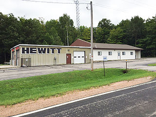
Hewitt is a town in Marathon County, Wisconsin, United States. It is part of the Wausau, Wisconsin Metropolitan Statistical Area. The population was 606 at the 2010 census. The unincorporated community of Glandon is located in the town.

<span class="mw-page-title-main">Wagner, Wisconsin</span> Town in Wisconsin, United States

Wagner is a town in Marinette County, Wisconsin, United States. The population was 722 at the 2000 census. The unincorporated communities of Goll, McAllister, Packard, and Wagner are located in the town.

<span class="mw-page-title-main">Van Buren, Maine</span> Town in Maine, United States

Van Buren is a town on the Saint John River in Aroostook County, Maine, United States; located across from Saint-Leonard, New Brunswick, Canada. The population was 2,038 at the 2020 census. It is named after U.S. President Martin Van Buren.

Milford is a town in Penobscot County, Maine, United States. It is located across the Penobscot River from the city of Old Town. The population of Milford was 3,069 at the 2020 census. The town's slogan is the "Best little town by a dam site," referring to the Milford Dam abutting Milford on the Penobscot River, south of the Penobscot Indian Island Reservation.

References

  1. 1 2 "US Gazetteer files 2010". United States Census Bureau . Retrieved December 16, 2012.
  2. "Census - Geography Profile: Topsfield town, Washington County, Maine". United States Census Bureau . Retrieved March 12, 2022.
  3. Climate Summary for Topsfield, Maine
  4. "NOWData – NOAA Online Weather Data". National Oceanic and Atmospheric Administration. Retrieved August 18, 2022.
  5. "U.S. Climate Normals Quick Access – Station: Topsfield 2, ME". National Oceanic and Atmospheric Administration. Retrieved December 30, 2022.
  6. "Census of Population and Housing". Census.gov. Retrieved June 4, 2015.
  7. "U.S. Census website". United States Census Bureau . Retrieved December 16, 2012.
  8. "U.S. Census website". United States Census Bureau . Retrieved January 31, 2008.

45°25′08″N67°44′08″W / 45.41889°N 67.73556°W / 45.41889; -67.73556