Whitneyville, Maine

Last updated

Whitneyville, Maine
WhitneyvilleME Library.jpg
The old library building
USA Maine location map.svg
Red pog.svg
Whitneyville, Maine
Location within the state of Maine
Coordinates: 44°43′33″N67°31′44″W / 44.72583°N 67.52889°W / 44.72583; -67.52889
Country United States
State Maine
County Washington
Area
[1]
  Total15.19 sq mi (39.34 km2)
  Land14.88 sq mi (38.54 km2)
  Water0.31 sq mi (0.80 km2)
Elevation
79 ft (24 m)
Population
 (2020)
  Total202
  Density13/sq mi (5.2/km2)
Time zone UTC-5 (Eastern (EST))
  Summer (DST) UTC-4 (EDT)
ZIP code
04654
Area code 207
FIPS code 23-85290
GNIS feature ID0582814

Whitneyville is a town in Washington County, Maine, United States. The town was named after Colonel Joseph Whitney, a mill owner. [2] The population was 202 at the 2020 census. [3]

Contents

Geography

According to the United States Census Bureau, the town has a total area of 15.19 square miles (39.34 km2), of which 14.88 square miles (38.54 km2) is land and 0.31 square miles (0.80 km2) is water. [1]

Demographics

Historical population
CensusPop.Note
1850 519
1860 57911.6%
1870 569−1.7%
1880 492−13.5%
1890 413−16.1%
1900 4242.7%
1910 258−39.2%
1920 210−18.6%
1930 2299.0%
1940 26214.4%
1950 227−13.4%
1960 2290.9%
1970 155−32.3%
1980 26470.3%
1990 241−8.7%
2000 2628.7%
2010 220−16.0%
2020 202−8.2%
U.S. Decennial Census [4]

2010 census

As of the census [5] of 2010, there were 220 people, 101 households, and 61 families living in the town. The population density was 14.8 inhabitants per square mile (5.7/km2). There were 127 housing units at an average density of 8.5 per square mile (3.3/km2). The racial makeup of the town was 98.2% White, 0.5% African American, 0.5% Asian, and 0.9% from other races. Hispanic or Latino of any race were 2.7% of the population.

There were 101 households, of which 20.8% had children under the age of 18 living with them, 45.5% were married couples living together, 7.9% had a female householder with no husband present, 6.9% had a male householder with no wife present, and 39.6% were non-families. 28.7% of all households were made up of individuals, and 9% had someone living alone who was 65 years of age or older. The average household size was 2.18 and the average family size was 2.69.

The median age in the town was 47 years. 15% of residents were under the age of 18; 10% were between the ages of 18 and 24; 20.4% were from 25 to 44; 38.7% were from 45 to 64; and 15.9% were 65 years of age or older. The gender makeup of the town was 51.8% male and 48.2% female.

2000 census

As of the census [6] of 2000, there were 262 people, 105 households, and 61 families living in the town. The population density was 18.3 people per square mile (7.1/km2). There were 139 housing units at an average density of 9.7 per square mile (3.8/km2). The racial makeup of the town was 98.85% White, 0.76% from other races, and 0.38% from two or more races. Hispanic or Latino of any race were 1.15% of the population.

There were 105 households, out of which 30.5% had children under the age of 18 living with them, 41.0% were married couples living together, 11.4% had a female householder with no husband present, and 41.9% were non-families. 33.3% of all households were made up of individuals, and 16.2% had someone living alone who was 65 years of age or older. The average household size was 2.50 and the average family size was 3.28.

In the town, the population was spread out, with 27.5% under the age of 18, 5.7% from 18 to 24, 26.3% from 25 to 44, 25.2% from 45 to 64, and 15.3% who were 65 years of age or older. The median age was 39 years. For every 100 females, there were 91.2 males. For every 100 females age 18 and over, there were 90.0 males.

The median income for a household in the town was $30,000, and the median income for a family was $48,750. Males had a median income of $26,667 versus $30,250 for females. The per capita income for the town was $13,115. About 3.5% of families and 10.3% of the population were below the poverty line, including 6.3% of those under the age of eighteen and 13.5% of those 65 or over.

Related Research Articles

<span class="mw-page-title-main">Malvern, Alabama</span> Town in Alabama, United States

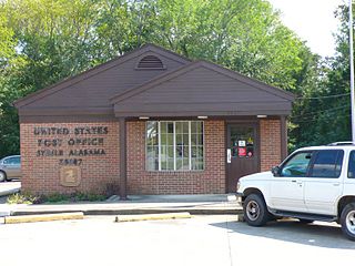
Malvern is a town in Geneva County, Alabama, United States. It is part of the Dothan, Alabama Metropolitan Statistical Area. At the 2010 census the population was 1,448, up from 1,215 in 2000.

<span class="mw-page-title-main">Steele, Alabama</span> Town in Alabama, United States

Steele is a town in northeastern St. Clair County, Alabama, United States. It was incorporated in 1952. At the 2010 census the population was 1,043, down from 1,093. The town is a part of the Birmingham–Hoover–Cullman Combined Statistical Area. It was initially known as Steel's Station or Steele's Depot in the late 19th century.

<span class="mw-page-title-main">Eagle Lake, Maine</span> Town in the state of Maine, United States

Eagle Lake is a town in Aroostook County, Maine, United States. The population was 772 at the 2020 census. The town was named by a body of troops heading from Bangor to the Aroostook War for the many eagles that they saw around the lake. A total of 49.0% of the population speaks French, reflecting a trend in Northeastern Maine.

<span class="mw-page-title-main">Mapleton, Maine</span> Town in the state of Maine, United States

Mapleton is a town in Aroostook County, Maine, United States. The population was 1,886 at the 2020 census.

<span class="mw-page-title-main">Merrill, Maine</span> Town in the state of Maine, United States

Merrill is a town in Aroostook County, Maine, United States. The population was 208 at the 2020 census.

<span class="mw-page-title-main">Wallagrass, Maine</span> Town in the state of Maine, United States

Wallagrass is a town in Aroostook County, Maine, United States. The population was 519 at the 2020 census.

Waltham is a town in Hancock County, Maine, United States. The population was 332 at the 2020 census.

<span class="mw-page-title-main">Manchester, Maine</span> Town in Maine, United States

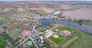
Manchester is a town in Kennebec County, Maine, United States, located at 44.33°N 69.87°W. The population was 2,456 at the 2020 census. The southern part of the town bordering Cobbosseecontee Lake is a popular recreation spot in central Maine, and part of the Winthrop Lakes Region. Manchester is included in the Augusta, Maine micropolitan and included in the Lewiston-Auburn, Maine metropolitan New England City and Town Area.

<span class="mw-page-title-main">Vienna, Maine</span> Town in the state of Maine, United States

Vienna is a town in Kennebec County, Maine, United States. The population was 578 at the 2020 census.

<span class="mw-page-title-main">Byron, Maine</span> Town in the state of Maine, United States

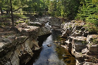
Byron is a town in Oxford County, Maine, United States. The population was 103 at the 2020 census. Home to Coos Canyon on the Swift River, Byron includes the village of Houghton.

Lakeville is a town in Penobscot County, Maine, United States. The population was 104 at the 2020 census.

Beddington is a town in Washington County, Maine, United States. The population was 60 at the 2020 census. It is the third-smallest organized town in Maine after Frye Island and Frenchboro.

<span class="mw-page-title-main">Reedy, West Virginia</span> Town in West Virginia, United States

Reedy is a town in Roane County, West Virginia, United States. The population was 152 at the 2020 census.

<span class="mw-page-title-main">Pine Grove, West Virginia</span> Town in West Virginia, United States

Pine Grove is a town in Wetzel County, West Virginia, United States. The population was 363 at the 2020 census. The community was named for a grove of pine trees near the original town site.

<span class="mw-page-title-main">North Hills, West Virginia</span> Town in West Virginia, United States

North Hills is a town in Wood County, West Virginia, United States. It is a suburb of Parkersburg. The population was 837 at the 2020 census. North Hills was incorporated on February 15, 1979.

<span class="mw-page-title-main">Cazenovia, Wisconsin</span> Village in Wisconsin, United States

Cazenovia is a village in Richland and Sauk Counties in the U.S. state of Wisconsin. The population was 318 at the 2010 census. Of this, 314 were in Richland County, and only 4 were in Sauk County.

Loyal is a town in Clark County in the U.S. state of Wisconsin. The population was 787 at the 2000 census. The City of Loyal is located within the town. The unincorporated community of Spokeville is also located partially in the town.

<span class="mw-page-title-main">Luxemburg (town), Wisconsin</span>

Luxemburg is a town in Kewaunee County, Wisconsin, United States. The population was 1,469 at the 2010 census. The village of Luxemburg, a separate municipality, is surrounded by the town. The unincorporated communities of Walhain and Casco Junction are in the town, and Neuern, Frog Station, and Tonet are partially in the town.

Darien is a town in Walworth County, Wisconsin, United States. The population was 1,651 at the 2020 census. The Village of Darien is located within the town. The unincorporated community of Bardwell is located in the town. The unincorporated communities of Allen's Grove and Fairfield are also located partially in the town.

<span class="mw-page-title-main">Oakland (CDP), Maine</span> Census-designated place in Maine, United States

Oakland is a census-designated place (CDP) comprising the main population center in the town of Oakland in Kennebec County, Maine, United States. The population was 2,602 at the 2010 census, out of 6,240 in the entire town of Oakland.

References

  1. 1 2 "US Gazetteer files 2010". United States Census Bureau . Retrieved December 16, 2012.
  2. "Profile for Whitneyville, Maine". ePodunk . Retrieved May 8, 2010.
  3. "Census - Geography Profile: Whitneyville town, Washington County, Maine". United States Census Bureau . Retrieved March 12, 2022.
  4. "Census of Population and Housing". Census.gov. Retrieved June 4, 2015.
  5. "U.S. Census website". United States Census Bureau . Retrieved December 16, 2012.
  6. "U.S. Census website". United States Census Bureau . Retrieved January 31, 2008.

44°43′19″N67°31′24″W / 44.72194°N 67.52333°W / 44.72194; -67.52333