Boston Harbor, Washington

Last updated

Boston Harbor
Boston Harbor, WA Sunset.jpg
Boston Harbor
USA Washington location map.svg
Red pog.svg
Boston Harbor
Usa edcp location map.svg
Red pog.svg
Boston Harbor
Coordinates: 47°8′19.22″N122°54′4.24″W / 47.1386722°N 122.9011778°W / 47.1386722; -122.9011778
Country United States
State Washington
County Thurston
Elevation
19 ft (6 m)
Time zone UTC-8 (Pacific (PST))
  Summer (DST) UTC-7 (Pacific (PDT))
ZIP code
98506
Area code 360

Boston Harbor is an unincorporated community in Thurston County, Washington. The community is home to the Dofflemyer Point Light, built in 1934 and listed on the National Register of Historic Places in 1995.

Contents

History

Seattle real estate developer C. D. Hillman platted the site in 1907 and promoted sale of lots by offering cash prizes to buyers. [1]

Geography

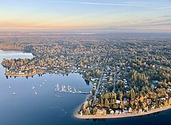
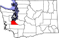
Boston Harbor is located at the intersection of Pickering Passage and Dana Passage, with outlying parts also falling along Budd Inlet. It is located between Dover Point and Dofflemyer Point, which is marked by a distinctive concrete lighthouse that is not publicly accessible by land. [2] Boston Harbor is a formerly rural area that has now become an exurb of Olympia, Washington.

Parks and recreation

The community is home to the Boston Harbor Marina and sits near Squaxin Park (formerly Priest Point Park) and Burfoot Park. [3] The marina is often the location for community social gatherings, most notably in the Spring and Summer months. A public boat launch adjacent the marina is jointly owned by the Washington Department of Fish and Wildlife (WDFW) and Thurston County.

Education

Children in the area attend the formerly independent Boston Harbor School [4] since the early 1900s, now part of the Olympia School District. The school also serves as a community center for the rural area of northern Thurston County.

See also

Related Research Articles

<span class="mw-page-title-main">Whidbey Island</span> Island in Puget Sound in Washington, United States

Whidbey Island is the largest of the islands composing Island County, Washington, in the United States, and the largest island in Washington state. Whidbey is about 30 miles (48 km) north of Seattle, and lies between the Olympic Peninsula and the I-5 corridor of western Washington. The island forms the northern boundary of Puget Sound. It is home to Naval Air Station Whidbey Island. The state parks and natural forests are home to numerous old growth trees.

<span class="mw-page-title-main">Olympia, Washington</span> Capital city of Washington, United States

Olympia is the capital of the U.S. state of Washington and the county seat and most populous city of Thurston County. It is 60 miles (100 km) southwest of the state's most populous city, Seattle, and is a cultural center of the southern Puget Sound region.

<span class="mw-page-title-main">Thurston County, Washington</span> County in Washington, United States

Thurston County is a county located in the U.S. state of Washington. As of the 2020 census, its population was 294,793. The county seat and largest city is Olympia, the state capital.

<span class="mw-page-title-main">Marina del Rey, California</span> Unincorporated community in the United States

Marina del Rey is an unincorporated seaside community in Los Angeles County, California, with an eponymous harbor that is a major boating and water recreation destination of the greater Los Angeles area. The port is North America's largest man-made small-craft harbor and is home to approximately 5,000 boats. The area is a popular tourism destination for both land and water activities such as paddle board and kayak rentals, dining cruises, and yacht charters. Land activities include bicycling on several bicycle paths, walking paths along the waterfront, and birdwatching (birding). Wildlife watching opportunities include California sea lions and harbor seals. Dolphins and whales occasionally visit the deeper waters of harbor. This Westside locale is approximately 4 miles (6.4 km) south of Santa Monica, 4 miles (6.4 km) north of Los Angeles International Airport, and 12.5 miles (20.1 km) west-southwest of Downtown Los Angeles.

<span class="mw-page-title-main">Des Moines, Washington</span> City in Washington, United States

Des Moines is a city in King County, Washington, United States. The population was 32,888 as of the 2020 census. The city is located on the east shore of Puget Sound, near the center of the Seattle metropolitan area. It is bordered by the suburbs of Federal Way to the south, Kent to the east, SeaTac to the northeast, Burien to the north, and Normandy Park to the northwest.

<span class="mw-page-title-main">Lacey, Washington</span> City in Washington, United States

Lacey is a city in Thurston County, Washington, United States. It is a suburb of Olympia with a population of 53,526 at the 2020 census, making it the 24th most populous city in Washington. Lacey is located along Interstate 5 between Olympia and the Nisqually River, which marks the border with Pierce County and Joint Base Lewis–McChord.

<span class="mw-page-title-main">Leamington, Ontario</span> Town in Ontario, Canada

Leamington is a municipality in Essex County, Ontario, Canada. With a population of 29,680 in the Canada 2021 Census, it forms the second largest urban centre in Windsor-Essex County after Windsor, Ontario. It includes Point Pelee National Park, the southernmost point of mainland Canada.

<span class="mw-page-title-main">Charlestown, Boston</span> Neighborhood in Boston, Massachusetts, United States

Charlestown is the oldest neighborhood in Boston, Massachusetts, in the United States. Also called Mishawum by the Massachusett, it is located on a peninsula north of the Charles River, across from downtown Boston, and also adjoins the Mystic River and Boston Harbor waterways. Charlestown was laid out in 1629 by engineer Thomas Graves, one of its earliest settlers, during the reign of Charles I of England. It was originally a separate town and the first capital of the Massachusetts Bay Colony.

<span class="mw-page-title-main">Oxon Hill, Maryland</span> Census-designated place in Maryland

Oxon Hill is an unincorporated area and census-designated place (CDP) in southern Prince George's County, Maryland, United States. Oxon Hill is a suburb of Washington, located southeast of the downtown district and east of Alexandria, Virginia. Since 2008, it contains the 300-acre (120 ha) National Harbor development on the shore of the Potomac River.

<span class="mw-page-title-main">Dorchester, Boston</span> Neighborhood of Boston in Suffolk, Massachusetts, United States

Dorchester is a Boston neighborhood comprising more than 6 square miles (16 km2) in the City of Boston, Massachusetts, United States. Originally, Dorchester was a separate town, founded by Puritans who emigrated in 1630 from Dorchester, Dorset, England, to the Massachusetts Bay Colony. This dissolved municipality, Boston's largest neighborhood by far, is often divided by city planners in order to create two planning areas roughly equivalent in size and population to other Boston neighborhoods.

<span class="mw-page-title-main">Seattle metropolitan area</span> Metropolitan statistical area in Washington, United States

The Seattle metropolitan area is an urban conglomeration in the U.S. state of Washington that comprises Seattle, its surrounding satellites and suburbs. It contains the three most populous counties in the state, King, Pierce, and Snohomish counties, and is considered part of the greater Puget Sound region. The United States Census Bureau defines the metropolitan area as the Seattle–Tacoma–Bellevue, WA metropolitan statistical area. With an estimated population of 4,102,400 as of 2022, it is the 15th-largest metropolitan statistical area (MSA) in the United States and home to over half of Washington's population.

<span class="mw-page-title-main">Copper Harbor, Michigan</span> Census-designated place & unincorporated community in Michigan, United States

Copper Harbor is an unincorporated community and census-designated place (CDP) located in Keweenaw County in the U.S. state of Michigan. It is located within Grant Township. The population of the CDP was 136 as of the 2020 census.

<span class="mw-page-title-main">Dofflemyer Point Light</span> Lighthouse

The Dofflemyer Point Lighthouse is a U.S. lighthouse in Boston Harbor, Washington, and was one of the first in the state of Washington to be automated. It sits at the northeastern entrance to Budd Inlet north of Olympia. It is the southernmost light in Puget Sound and is listed on the National Register of Historic Places.

<span class="mw-page-title-main">Timberland Regional Library</span>

Timberland Regional Library (TRL) is a public library system serving the residents of western Washington state, United States including Grays Harbor, Lewis, Mason, Pacific, and Thurston counties. Timberland Regional Library has 27 community libraries, 2 cooperative library centers, and 3 library kiosks. It was founded in 1968, following a four-year demonstration project, and is funded through property taxes and timber taxes.

<span class="mw-page-title-main">Washington State Route 548</span>

State Route 548 (SR 548) is a state highway in Whatcom County, Washington, United States. It travels for 14 miles (23 km) between Ferndale and Blaine, terminating at interchanges with Interstate 5 (I-5) at both ends. SR 548 in Blaine, named Peace Portal Drive, follows the route of the Pacific Highway, later U.S. Route 99 (US 99) and Primary State Highway 1 (PSH 1). US 99 was decommissioned during the 1964 highway renumbering and the highway was maintained by Whatcom County until it was designated as SR 548 in 1991.

<span class="mw-page-title-main">Percival Landing Park</span>

Percival Landing Park is a public park located in Olympia, Washington.

<span class="mw-page-title-main">Squaxin Park</span> Park in Olympia, Washington

Squaxin Park is a public park located in Olympia, Washington. Established in 1905, it was the city's first waterfront park, providing access to the Budd Inlet of Puget Sound. The park was formerly known as Priest Point Park, but was renamed in 2022 after the Olympia City Council unanimously voted to change it to honor the local Squaxin island Tribe.

East Olympia is an unincorporated community in Thurston County, Washington, United States. The community is 6 miles (9.7 km) south-southeast of downtown Olympia.

<span class="mw-page-title-main">Mason Transit Authority</span>

The Mason Transit Authority (MTA), formerly the Mason County Transportation Authority, is the public transit authority of Mason County, Washington, United States. It operates free bus service within the county, connecting the city of Shelton, Hoodsport, Grapeview, Allyn, Belfair, the native tribal reservations of the Skokomish and Squaxin people, and paid commuter service to Olympia in Thurston County, Brinnon in Jefferson County, and Bremerton in Kitsap County. The agency also provides general public dial-a-ride service, operates a vanpool fleet, a worker/driver program that provides commuter service to the Puget Sound Naval Shipyard and Intermediate Maintenance Facility, volunteer driver program for senior transportation, a supplemental service that is an after school activity bus and a community van program.

<span class="mw-page-title-main">South Puget Sound</span> Region in Washington, United States

South Puget Sound is the southern reaches of Puget Sound in Southwest Washington, in the United States' Pacific Northwest. It is one of five major basins encompassing the entire Sound, and the shallowest basin, with a mean depth of 37 meters (121 ft). Exact definitions of the region vary: the state's Department of Fish and Wildlife counts all of Puget Sound south of the Tacoma Narrows for fishing regulatory purposes. The same agency counts Mason, Jefferson, Kitsap, Pierce and Thurston Counties for wildlife management. The state's Department of Ecology defines a similar area south of Colvos Passage.

References

  1. Younkman v. Hillman, 1909 Washington State Supreme Court opinion. Retrieved 11/19/19.
  2. Mueller, M. and Mueller, T. (2006) Afoot & Afloat South Puget Sound. The Mountaineers Books. p 265.
  3. Judd, R.C. (2001) Inside Out Washington: A Best Places Guide to the Outdoors. Sasquatch Books. p 25.
  4. Boston Harbor School Archived August 12, 2011, at the Wayback Machine official website. Retrieved 9/7/11.