
Grand Mound is a community and census-designated place (CDP) in Thurston County, Washington, United States. It was named and founded by Jotham Weeks Judson, father of Phoebe Judson, in 1851. The population was 2,981 at the 2010 census. This area uses the 98579 and 98531 zip codes, which also includes Rochester and Gate.

The Chehalis people or Tsihalis are a native people of western Washington state in the United States. They should not be confused with the similarly named Chehalis First Nation of the Sts'Ailes people along the Harrison River in the Fraser Valley area of British Columbia.

The Newaukum River is a tributary of the Chehalis River in the U.S. state of Washington. It has three main branches, the North Fork, South Fork, and Middle Fork Newaukum Rivers. The length of the three forks and the mainstem river is 56.7 miles (91.2 km).

The Skookumchuck River is a 45-mile (72 km) long river located in southwest Washington, United States. It is a tributary of the Chehalis River and thence to the Pacific Ocean. The Skookumchuck Dam was built in 1970, creating the Skookumchuck Reservoir. The dam provides water supply for the 1400-megawatt Centralia Steam Electric Plant and supplements flows for fish resources. The river begins with several tributaries in the Snoqualmie National Forest in the foothills of the Cascade Mountains, and flows west past the town of Bucoda, Washington to its confluence with the Chehalis River near Centralia, Washington.
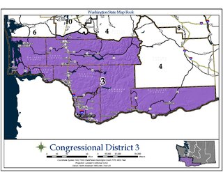
Washington's 3rd congressional district encompasses the southernmost portion of western and central Washington. It includes the counties of Lewis, Pacific, Wahkiakum, Cowlitz, Clark, Skamania, and Klickitat, as well as a small sliver of southern Thurston county. The 3rd District is represented by Republican Jaime Herrera Beutler.

The Chehalis Western Trail is a rail trail in Washington. Communities on the trail include Olympia, South Bay, Lacey, East Olympia, Skookumchuck, and Rainier.
The Yelm–Tenino Trail is a rail trail located in Thurston County, Washington, United States. The 14.5-mile (23.3 km) long cycling and walking trail has been constructed along the route of a former Burlington Northern Railroad line. The trail runs parallel to State Route 507 and intersects with the Chehalis Western Trail. Trailheads are located at the trail termini in the towns of Yelm and Tenino as well as in the town of Rainier.

The Black River is a river in Thurston County in the U.S. state of Washington. It is approximately 25 miles (40 km) long with a drainage basin of about 144 square miles (370 km2). The Black River's source is Black Lake, located about 3 miles (4.8 km) west of Tumwater. The river flows generally south, through the Mima Mounds State Natural Area, then southwest, passing by Rochester and entering Grays Harbor County, then emptying into the Chehalis River in the Chehalis Indian Reservation.
The Vintage Motorcycle Museum is a museum in Chehalis, Washington. The collection, founded in 1979 by retired building contractor Frank Mason, includes pre-1916 motorcycles, photographs and memorabilia. Mason and his wife Barbara bought and renovated the historic 1889 Washington Hotel building in Chehalis after it burned in 1997, and moved the collection there.
Chehalis–Centralia Airport is a county-owned public use airport located in Chehalis, a city in Lewis County, Washington. The airport lies one mile west of the town.
Jackson Prairie Underground Natural Gas Storage Facility is a natural gas storage facility in Southwest Washington, owned by Puget Sound Energy, Avista and Williams Companies's Northwest Pipeline GP. With 25 billion cubic feet working capacity, it is the largest natural gas-storage reservoir in the Pacific Northwest and the 14th largest in the United States.
Bush is an unincorporated community in Thurston County, in the U.S. state of Washington.
Johnson Creek is a stream in Thurston County in the U.S. state of Washington. It is a tributary to the Skookumchuck River.
Kellys Korner is an unincorporated community in Thurston County, in the U.S. state of Washington.
Prairie Creek is a stream in Thurston County in the U.S. state of Washington. It is a tributary to the Chehalis River.
Salmon Creek is a stream in Thurston County in the U.S. state of Washington. It is a tributary to the Skookumchuck River.
Thompson Creek is a stream in Lewis and Thurston counties in the U.S. state of Washington.It is a tributary to the Skookumchuck River. Its source is in Lewis County and its mouth is in Thurston County.
Troller Run is a stream in Thurston County in the U.S. state of Washington. It is a tributary to the Skookumchuck River.


