Grand Mound, Washington

Last updated

Grand Mound
CDP
Grand Mound town sign.jpg
Town sign for Grand Mound, located at main intersection
Thurston County Washington Incorporated and Unincorporated areas Grand Mound Highlighted.svg
Location of Grand Mound, Washington
Coordinates: 46°48′14″N123°0′36″W / 46.80389°N 123.01000°W / 46.80389; -123.01000
CountryUnited States
State Washington
County Thurston
Settled1851
Area
  Total3.93 sq mi (10.2 km2)
  Land3.93 sq mi (10.2 km2)
  Water0.0 sq mi (0 km2)
Elevation
167 ft (51 m)
Population
 (2020) [1]
  Total3,301
  Density840/sq mi (320/km2)
Time zone UTC-8 (Pacific (PST))
  Summer (DST) UTC-7 (PDT)
ZIP codes
98531, 98579
Area code(s) 360, 564
FIPS code 53-27890 [2]
GNIS feature ID1512250 [3]
Elevation [4]

Grand Mound is a community and census-designated place (CDP) in Thurston County, Washington, United States. [4] It was named and founded by Jotham Weeks Goodell, father of Phoebe Judson, in 1851. [5] The population was 3,301 at the 2020 census. [1] This area uses the 98579 and 98531 zip codes, which also includes Rochester and Gate.

Contents

History

Founded in 1851, stage service arrived in 1854. [6] In 1913, the Washington State School for Girls (also known as the State Training School for Girls) was created and opened on 70 acres (28 ha) in 1914. [7] [8] [9] The school was renamed to Maple Lane School in 1959, and closed in 2011. [8] [10]

In the 1920s, strawberries became a major crop in the area, and a processing plant was built, but during the Great Depression the industry failed and the Northern Pacific Railway closed the Grand Mound station. [6] By 1941 the population of the area had grown to about 200 people and the community had a post office along with a store and a single gas station. [9] In 1964, the Grand Mound Fire District was formed, merging twice, in 2002 with Thurston County Fire District #1, and then into the West Thurston Regional Fire Authority. [11] A new fire station was built to serve Grand Mound in 2007. [12]

The community became a census-designated place in 1990. In March 2008, a 398-room Great Wolf Lodge opened in Grand Mound, which was majority owned by the Confederated Tribes of the Chehalis Reservation. [13] [14]

Geography

Grand Mound is in the southern part of Thurston County, near the county line with Lewis County, immediately north of Centralia. Interstate 5 and U.S. Route 12 serve the community, with the latter leaving Interstate 5 at the Grand Mound exit to head west to Grays Harbor. According to the United States Census Bureau, the CDP has a total area of 3.93 square miles (10.2 km2), all of it land. It is located on Grand Mound Prairie, which was named after a 125-foot (38 m) tree-covered hill in the area, which was the largest of several similar mounds in the area. [9]

Prairie Creek is the only stream within the town's limits. It flows into the nearby Chehalis River, and the confluence of the two is located immediately southwest of the town. Scatter Creek can be found just north of Grand Mound, where it flows west through the Scatter Creek Wildlife Recreation Area and makes its way to its confluence with the Chehalis River, just south of nearby Rochester.

Just north of Grand Mound is the Scatter Creek Unit, a 915-acre (370.29-hectare) wildlife reserve which contains one of the few remaining areas of south Puget Sound prairie.

Demographics

Historical population
CensusPop.Note
1990 1,394
2000 1,94839.7%
2010 2,98153.0%
2020 3,30110.7%
U.S. Decennial Census [15]
2020 Census [1]

As of the census [2] of 2000, there were 1,948 people, 687 households, and 529 families residing in the CDP. The population density was 621.2 people per square mile (239.5/km2). There were 734 housing units at an average density of 234.1/sq mi (90.3/km2). The racial makeup of the CDP was 87.99% White, 0.31% African American, 1.23% Native American, 0.31% Asian, 0.10% Pacific Islander, 6.62% from other races, and 3.44% from two or more races. Hispanic or Latino of any race were 10.16% of the population.

There were 687 households, out of which 38.0% had children under the age of 18 living with them, 57.2% were married couples living together, 12.7% had a female householder with no husband present, and 22.9% were non-families. 16.7% of all households were made up of individuals, and 5.4% had someone living alone who was 65 years of age or older. The average household size was 2.84 and the average family size was 3.13.

In the CDP, the age distribution of the population shows 29.1% under the age of 18, 9.7% from 18 to 24, 30.9% from 25 to 44, 21.2% from 45 to 64, and 9.1% who were 65 years of age or older. The median age was 33 years. For every 100 females, there were 104.6 males. For every 100 females age 18 and over, there were 102.8 males.

The median income for a household in the CDP was $42,153, and the median income for a family was $41,864. Males had a median income of $40,250 versus $24,511 for females. The per capita income for the CDP was $16,008. About 13.5% of families and 14.8% of the population were below the poverty line, including 18.6% of those under age 18 and 12.5% of those age 65 or over.

Arts and culture

Historic buildings and sites

Several historical markers can be found in Grand Mound. A historical marker in the community commemorates a successful attempt by the townswomen of Grand Mound to vote in Washington territorial elections. Just south of Grand Mound, on Old Highway 99, is an Oregon Trail marker, established in 1916 by the Daughters and Sons of the American Revolution. A monument across from Grand Mound Cemetery marks the former location of Ft. Henness, a stockade built and occupied during the Puget Sound War of 1855-56. [16]

Parks and recreation

The South Sound Speedway, a Figure 8 racetrack, is immediately northeast of the downtown area.

Government

Interior of the Great Wolf Lodge in Grand Mound Great Wolf Lodge interior - Grand Mound, Washington.jpg
Interior of the Great Wolf Lodge in Grand Mound

Fire and emergency services are provided by the West Thurston Regional Fire Authority, with a single station located along Sargent Road. [12] Grand Mound lacks a post office. Mail delivery is largely provided by the post office in neighboring Rochester; most locations in Grand Mound have Rochester addresses. A few locations on the south side of Grand Mound have Centralia addresses.

See also

Related Research Articles

<span class="mw-page-title-main">Thurston County, Washington</span> County in Washington, United States

Thurston County is a county located in the U.S. state of Washington. As of the 2020 census, its population was 294,793. The county seat and largest city is Olympia, the state capital.

<span class="mw-page-title-main">Lewis County, Washington</span> County in Washington, United States

Lewis County is a county in the U.S. state of Washington. As of the 2020 census, the county's population was 82,149. The county seat is Chehalis, and its largest city is Centralia. Lewis County comprises the Centralia, WA Micropolitan Statistical Area, which is also included in the Seattle-Tacoma, WA Combined Statistical Area.

<span class="mw-page-title-main">Prairie Creek, Arkansas</span> CDP in Arkansas, United States

Prairie Creek is a census-designated place (CDP) in Benton County, Arkansas, United States. Per the 2020 census, the population was 2,217. It is a lakefront community adjacent to Beaver Lake and Rogers within the Northwest Arkansas region.

<span class="mw-page-title-main">Rockcreek, Oregon</span> Unincorporated community in the state of Oregon, United States

Rockcreek is a census-designated place in Washington County, Oregon, United States, north of U.S. Route 26. It is named for the Rock Creek neighborhood in the area. As of the 2010 census, the CDP population was 9,316. Named for Rock Creek, a tributary of the Tualatin River, that flows north to south through the neighborhood.

<span class="mw-page-title-main">Barberton, Washington</span> Census-designated place in Washington, United States

Barberton is a census-designated place (CDP) in Clark County, Washington, United States. The population was 8,567 at the 2020 census.

<span class="mw-page-title-main">Brady, Washington</span> Census-designated place in Washington, United States

Brady is a census-designated place (CDP) in Grays Harbor County, Washington, United States. The population was 676 at the 2010 census.

<span class="mw-page-title-main">Chehalis Village, Washington</span> Former CDP in Washington, United States

Chehalis Village is a former census-designated place (CDP) in Grays Harbor County, Washington, United States. The population was 346 at the 2000 census. The area was no longer listed as a CDP for the 2010 census.

<span class="mw-page-title-main">Copalis Beach, Washington</span> CDP in Washington, United States

Copalis Beach is a census-designated place (CDP) in Grays Harbor County, Washington, United States. The population was 415 at the 2010 census.

<span class="mw-page-title-main">Junction City, Washington</span> Census-designated place in Washington, United States

Junction City is a census-designated place (CDP) in Grays Harbor County, Washington, United States. The population was 18 at the 2010 census.

<span class="mw-page-title-main">Moclips, Washington</span> Census-designated place in Washington, United States

Moclips is an unincorporated community and census-designated place (CDP) in Grays Harbor County, Washington, United States. The population was 207 at the 2010 census. It is located near the mouth of the Moclips River.

<span class="mw-page-title-main">Centralia, Washington</span> City in Washington, United States

Centralia is a city in Lewis County, Washington, United States. It is located along Interstate 5 near the midpoint between Seattle and Portland, Oregon. The city had a population of 18,183 at the 2020 census. Centralia is twinned with Chehalis, located to the south near the confluence of the Chehalis and Newaukum rivers.

<span class="mw-page-title-main">Fords Prairie, Washington</span> Census-designated place in Washington, United States

Fords Prairie is an unincorporated community and census-designated place (CDP) in Lewis County, Washington, United States. The population was 2,234 at the 2020 census.

<span class="mw-page-title-main">Lebam, Washington</span> CDP in Washington, United States

Lebam is a census-designated place (CDP) in Pacific County, Washington, United States. The population was 160 at the 2010 census. At the 2020 census the population was 150. 16 percent had a Bachelor’s degree or higher. The employment rate was 45.6 percent.

<span class="mw-page-title-main">Nisqually Reservation</span> CDP in Washington, United States

The Nisqually Reservation, also known as Nisqually Indian Reservation is a federally recognized Indian reservation in Thurston County, Washington, United States. The population was 668 at the 2020 census.

<span class="mw-page-title-main">Rainier, Washington</span> City in Washington, United States

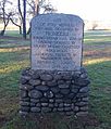
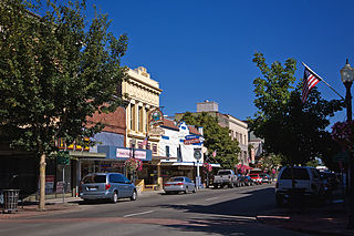
Rainier is a city in Thurston County, Washington, United States. Beginning as a train stop in the 1870s, Rainier was first settled in 1890 and would become known as a logging town. The city was officially incorporated in 1947.

<span class="mw-page-title-main">Rochester, Washington</span> Place in Washington State

Rochester is a census-designated place (CDP) in Thurston County, Washington, United States. It was founded in 1852, and the 2020 census recorded its population at 6,064. According to the United States Census Bureau, the CDP has a total area of 2.3 square miles, all of it land. Rochester Schools had 2,105 students registered in 2021-22 School Year.

<span class="mw-page-title-main">Tanglewilde, Washington</span> CDP in Washington, United States

Tanglewilde is a census-designated place (CDP) in Thurston County, Washington, United States, part of the Urban Growth Area of the city of Lacey.

<span class="mw-page-title-main">Yelm, Washington</span> City in Washington, United States

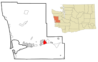
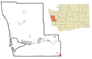
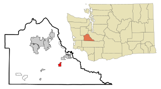
Yelm is a city in Thurston County, Washington, United States. Its population was 10,617 at the 2020 census.

<span class="mw-page-title-main">Brice Prairie, Wisconsin</span> Census-designated place in Wisconsin, United States

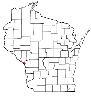
Brice Prairie is a census-designated place (CDP) in La Crosse County, Wisconsin, United States. The population was 1,887 at the 2010 census. Brice Prairie is located in the Town of Onalaska.

<span class="mw-page-title-main">Porter, Washington</span> Census-designated place in Washington, United States

Porter is an unincorporated community and census-designated place (CDP) in Grays Harbor County, Washington, United States. The population was 207 at the 2010 census. Prior to 2010 it was part of the Malone-Porter CDP; Malone and Porter are now separate CDPs. They are located just off U.S. Route 12, southeast of Elma and northwest of Oakville, and along a shortline that is part of the Puget Sound and Pacific Railroad.

References

  1. 1 2 3 "2020 Census Redistricting Data (Public Law 94-171) Summary File". American FactFinder. United States Census Bureau . Retrieved May 15, 2022.
  2. 1 2 "U.S. Census website". United States Census Bureau . Retrieved January 31, 2008.
  3. "US Board on Geographic Names". United States Geological Survey. October 25, 2007. Retrieved January 31, 2008.
  4. 1 2 "Grand Mound, Washington". Geographic Names Information System . United States Geological Survey, United States Department of the Interior . Retrieved May 19, 2014.
  5. Judson, Phoebe Goodell (1984) [1925]. A Pioneer's Search for an Ideal Home: A Book of Personal Memoirs . Lincoln, Nebraska: University of Nebraska Press. p. 86. ISBN   0-8032-2563-6.
  6. 1 2 Kirk, Ruth (1995). Exploring Washington's Past: A Road Guide to History. University of Washington Press. pp. 352–353.
  7. Ott, Jen (July 2, 2008). "Washington State Reform School opens in Chehalis on June 10, 1891". HistoryLink.org. Retrieved April 20, 2014.
  8. 1 2 Kaelber, Lutz. "Washington". Eugenics: Compulsory Sterilization in 50 American States. University of Vermont. Retrieved April 20, 2014.
  9. 1 2 3 Federal Writers' Project, ed. (1941). The New Washington: A Guide to the Evergreen State. Metropolitan Press. pp. 489–490.
  10. Shannon, Brad (April 7, 2011). "Shelton, Grand Mound finalists for new prison unit". The Olympian . Retrieved April 20, 2014.
  11. "History". About Us. West Thurston Regional Fire Authority. Archived from the original on January 12, 2010. Retrieved April 20, 2014.
  12. 1 2 "Stations". West Thurston Regional Fire Authority. Retrieved April 20, 2014.
  13. Adams, Barry (May 4, 2009). "Great Wolf Resorts selling its share in two properties". The Wisconsin State Journal. Madison, WI.
  14. Adams, Barry (August 6, 2008). "Great Wolf reports $4.1 million quarterly loss". The Wisconsin State Journal. Madison, WI.
  15. "CENSUS OF POPULATION AND HOUSING (1790-2000)". Census.gov. Retrieved July 31, 2010.
  16. http://www.co.thurston.wa.us/history/docs/markers/Fort-Henness-Monument.pdf [ bare URL PDF ]